Miranda: Verona Rupes |

  |
Miranda: Verona Rupes |
 Aug 31 2012, 11:51 PM Aug 31 2012, 11:51 PM
Post
#1
|
|
 Newbie  Group: Members Posts: 8 Joined: 9-August 12 From: Seattle, Washington (USA) Member No.: 6517 |
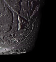
Hi...just wondering if anyone has a reliable source for the height of Miranda's spectacular Verona Rupes fault scarp? Estimates for the height range from 5 km to 20 km.
Thanks, --Phil -------------------- Twitter: @philna | seattle.wa.usa
|
 |
 
|
|
Sep 3 2012, 12:11 PM
Post
#2
|
|
 Senior Member Group: Members Posts: 1088 Joined: 19-February 05 From: Close to Meudon Observatory in France Member No.: 172 |
Well... Ask Phil Stooke, the "other Phil". He might know, having cartographed already most bodies of the solar system...
|
|
|
|
|
Sep 4 2012, 10:13 PM
Post
#3
|
|
|
Newbie Group: Members Posts: 8 Joined: 9-August 12 From: Seattle, Washington (USA) Member No.: 6517 |
I see...thanks for the suggestion.
--Phil -------------------- Twitter: @philna | seattle.wa.usa
|
|
|
|
|
Sep 4 2012, 10:45 PM
Post
#4
|
|
|
Solar System Cartographer Group: Members Posts: 10164 Joined: 5-April 05 From: Canada Member No.: 227 |
Hi - you'll have to wait until I get back from my current trip (I'm in the Irish Sea right now). When I have access to my stuff I'll see what I can find.
Verona Rupes is not vertical, it's a talus slope at angle of repose, so there may be differences between estimates of slope length versus actual depth. I had an LPSC abstract on that topic back in the Jurassic Period. Phil -------------------- ... because the Solar System ain't gonna map itself.
Also to be found posting similar content on https://mastodon.social/@PhilStooke Maps for download (free PD: https://upload.wikimedia.org/wikipedia/comm...Cartography.pdf NOTE: everything created by me which I post on UMSF is considered to be in the public domain (NOT CC, public domain) |
|
|
|
|
Sep 5 2012, 12:25 AM
Post
#5
|
|
|
Senior Member Group: Members Posts: 1583 Joined: 14-October 05 From: Vermont Member No.: 530 |
QUOTE (Phil Stooke @ Sep 4 2012, 05:45 PM)  Verona Rupes is not vertical, it's a talus slope at angle of repose I always wondered about that. I thought it looked suspiciously slope-like. Now I feel cheated-- what fun would be tumbling down low-G scree?? I always envisioned jumping off it and very slowly falling. I supposed I should adjust my vision to dropping a boulder off the top and creating a massive yet extremely slow avalanche/slough. |
|
|
|
|
Sep 6 2012, 01:47 AM
Post
#6
|
|
|
Newbie Group: Members Posts: 8 Joined: 9-August 12 From: Seattle, Washington (USA) Member No.: 6517 |
Very interesting Phil. I'd like to see your estimate of the slope angle and your abstract, if you're able to share it. Verona Rupes has a somewhat mythic reputation and much of the information about its depth is rather inconsistent. This is surprising given the exceptional quality of the 1986 Voyager 2 photos.
Thanks, --Phil -------------------- Twitter: @philna | seattle.wa.usa
|
|
|
|
|
Sep 7 2012, 09:00 PM
Post
#7
|
|
|
Solar System Cartographer Group: Members Posts: 10164 Joined: 5-April 05 From: Canada Member No.: 227 |
Exceptional quality, yes, but no stereo coverage of this area of Miranda, so no topography.
I'll be back home in a week... just south of Iceland at the moment... Phil -------------------- ... because the Solar System ain't gonna map itself.
Also to be found posting similar content on https://mastodon.social/@PhilStooke Maps for download (free PD: https://upload.wikimedia.org/wikipedia/comm...Cartography.pdf NOTE: everything created by me which I post on UMSF is considered to be in the public domain (NOT CC, public domain) |
|
|
|
|
Sep 7 2012, 10:16 PM
Post
#8
|
|
 Member Group: Members Posts: 444 Joined: 1-July 05 From: New York City Member No.: 424 |
off topic:
QUOTE (Phil Stooke @ Sep 4 2012, 06:45 PM) (I'm in the Irish Sea right now) QUOTE (Phil Stooke @ Sep 7 2012, 05:00 PM) just south of Iceland at the moment... I trust when you return you'll share an account of this wonderful sail, with pictures please. /off topic |
|
|
|
|
Sep 19 2012, 08:16 PM
Post
#9
|
|
|
Solar System Cartographer Group: Members Posts: 10164 Joined: 5-April 05 From: Canada Member No.: 227 |
Here is my 1991 LPSC abstract about Miranda.
http://www.lpi.usra.edu/meetings/lpsc1991/pdf/1667.pdf I can't believe I've been doing this for over 20 years... 26 actually as my first LPSC was in 1986. Phil -------------------- ... because the Solar System ain't gonna map itself.
Also to be found posting similar content on https://mastodon.social/@PhilStooke Maps for download (free PD: https://upload.wikimedia.org/wikipedia/comm...Cartography.pdf NOTE: everything created by me which I post on UMSF is considered to be in the public domain (NOT CC, public domain) |
|
|
|
|
Sep 19 2012, 09:31 PM
Post
#10
|
|
|
Member Group: Members Posts: 241 Joined: 16-May 06 From: Geneva, Switzerland Member No.: 773 |
I read this abstract many times Phil. This is the best study of the inter-coronae regions I have found so far. This geological map of Miranda is just great. I do not think that I will again see another mission to Uranus and it's amazing moons in my life (even if I'm "just" 42 !!). Maybe I'm too pessimistic !
Best Regards, Marc. |
|
|
|
|
Sep 27 2012, 07:17 PM
Post
#11
|
|
|
Newbie Group: Members Posts: 8 Joined: 9-August 12 From: Seattle, Washington (USA) Member No.: 6517 |
Thanks, Phil! ...I just returned fom vacation and found your abstract post. So the cliffs are likely more like 5 - 15 km. Would the base of the cliffs be filled a sloping mass of ice/rocky talus? I wonder how far this would spread out in low-g.
BTW, the abstract is now 404. Thanks, --Phil -------------------- Twitter: @philna | seattle.wa.usa
|
|
|
|
|
Oct 10 2012, 01:04 AM
Post
#12
|
|
 Member Group: Members Posts: 207 Joined: 6-March 07 From: houston, texas Member No.: 1828 |
check out this post for a year or so ago . . .
http://stereomoons.blogspot.com/2009/09/mi...as-warning.html Includes global map and topography of the south. I suppose i should write this up one of these days with some actual measurements and stuff . . . -------------------- Dr. Paul Schenk, Lunar and Planetary Institute, Houston TX
http://stereomoons.blogspot.com; http://www.youtube.com/galsat400; http://www.lpi.usra.edu/science/schenk/ |
|
|
|
|
Oct 13 2012, 11:31 PM
Post
#13
|
|
|
Newbie Group: Members Posts: 8 Joined: 9-August 12 From: Seattle, Washington (USA) Member No.: 6517 |
The video and still projections are fantastic! It looks like you're landing north of the Alonso crater near where Argiers and Verona Rupes meet. It would be interesting to to see this as a spherical projection, if you get around to it someday.
BTW, do you know if there's any evidence suggesting that Miranda is experiencing active cryovolcanism? It's such tortured terrain - reminds me of Enceladus. I realize Voyager 2 did not detect any plumes and that only half the satellite was imaged. Could ground-based telescopes have picked up the telltale traces of ammonia around Miranda? Oh, also, would you happen to know where I can find more info about how Miranda is interacting with the Uranian magnetosphere and radiation belts? (Disclaimer: I'm a software designer with a b/g in astronautics. When it comes to planetary science, I'm an enthusiatic noob and simply interested in learning.) Thanks again, --Phil -------------------- Twitter: @philna | seattle.wa.usa
|
|
|
|
|
Oct 13 2012, 11:52 PM
Post
#14
|
|
|
Merciless Robot Group: Admin Posts: 8784 Joined: 8-December 05 From: Los Angeles Member No.: 602 |
Shooting from the hip, here, I'd call active cryovulcanism unlikely in the modern era. Both the primary body & the other moons are significantly less massive than Jupiter & Saturn (and their own moons), so the tidal forces are correspondingly less as well.
Uranus clearly experienced something during its wild youth; a 98 deg polar inclination doesn't happen for nothing. The fact that its rings & moons are all equatorally coplanar implies that they formed after this event, whatever it was. But I suspect that this was the last & most significant energetic event that ever happened there cause, baby, it's COLD outside. -------------------- A few will take this knowledge and use this power of a dream realized as a force for change, an impetus for further discovery to make less ancient dreams real.
|
|
|
|
|
Oct 16 2012, 11:14 PM
Post
#15
|
|
|
Newbie Group: Members Posts: 8 Joined: 9-August 12 From: Seattle, Washington (USA) Member No.: 6517 |
QUOTE (nprev @ Oct 13 2012, 04:52 PM) Shooting from the hip, here, I'd call active cryovulcanism unlikely in the modern era. Both the primary body & the other moons are significantly less massive than Jupiter & Saturn (and their own moons), so the tidal forces are correspondingly less as well. Uranus clearly experienced something during its wild youth; a 98 deg polar inclination doesn't happen for nothing. The fact that its rings & moons are all equatorally coplanar implies that they formed after this event, whatever it was. But I suspect that this was the last & most significant energetic event that ever happened there cause, baby, it's COLD outside. True...and I think that's been the conventional thinking about the Uranian system. However, just today, this was posted on the Planetary Society blog regarding findings reported at the DSPS 2012 meeting: http://www.planetary.org/blogs/emily-lakda...4-dps-day1.html "...Uranus has a blue ring analogous to Saturn's E ring, which is of course supplied by Enceladus' geysers. Uranus' ring is associated positionally with the satellite Mab, which is way too tiny to have any hope of Enceladus-like activity. She suggested that there has been migration of the moons and/or ring material and that Ariel could originally have been the source and may relatively recently have been geologically active." Admittedly, Ariel is 20x more massive than Miranda (which is 1.5x less massive than Enceladus). Interesting... -------------------- Twitter: @philna | seattle.wa.usa
|
|
|
|
|
Oct 17 2012, 06:42 AM
Post
#16
|
||
 Member Group: Members Posts: 796 Joined: 27-February 08 From: Heart of Europe Member No.: 4057 |
Some parts of Ariel really looks like active regions on Enceladus. Especially region named Leprechaun Vallis.
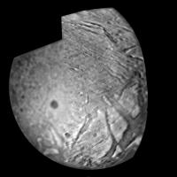
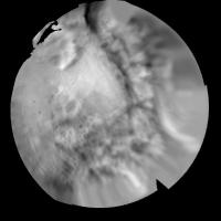
And of course, we don't know, how more than 50% of Ariel's surface looks even in moderate resolution (~1 km/pix). BTW, It's any possibility to derive "absolute" heights (measured from the center) for Miranda from available data? (This is in particular question for Paul, who is master in this field.)
Attached thumbnail(s)
-------------------- |
|
|
|
|
|
|
Oct 18 2012, 02:56 PM
Post
#17
|
|||
|
Member Group: Members Posts: 207 Joined: 6-March 07 From: houston, texas Member No.: 1828 |
QUOTE (machi @ Oct 17 2012, 01:42 AM) Some parts of Ariel really looks like active regions on Enceladus. Especially region named Leprechaun Vallis. And of course, we don't know, how more than 50% of Ariel's surface looks even in moderate resolution (~1 km/pix). BTW, It's any possibility to derive "absolute" heights (measured from the center) for Miranda from available data? (This is in particular question for Paul, who is master in this field.) here are JPGs of my elevation maps of Ariel and Miranda. getting absolute heights from center would require integrating with the limb profiles but the geometric distortions of the VGR cameras were only partially solved. a true solution wont come from VGR. best we can get is really good relative measures, and a close approx to absolute hts.
Attached thumbnail(s)
-------------------- Dr. Paul Schenk, Lunar and Planetary Institute, Houston TX
http://stereomoons.blogspot.com; http://www.youtube.com/galsat400; http://www.lpi.usra.edu/science/schenk/ |
||
|
|
|
||
|
Oct 18 2012, 05:24 PM
Post
#18
|
|
|
Member Group: Members Posts: 796 Joined: 27-February 08 From: Heart of Europe Member No.: 4057 |
Thanks for your answers, Paul!
-------------------- |
|
|
|
|
Oct 4 2014, 10:16 AM
Post
#19
|
|
|
Member Group: Members Posts: 241 Joined: 16-May 06 From: Geneva, Switzerland Member No.: 773 |
Global resurfacing of Uranus's moon Miranda by convection:
http://geology.gsapubs.org/content/early/2014/09/15/G36124.1 "Here we use numerical methods to show that sluggish-lid convection in Miranda's ice shell, powered by tidal heating, can simultaneously match the global distribution of coronae, the concentric deformation pattern, and the estimated heat flow during formation." http://www.space.com/27334-uranus-frankens...141004_32849726 "It'd be really interesting to think about what could be on the other side of Miranda," Hammond said. "Our study predicts there'd be one additional corona on Miranda's other side, and I would love to live long enough for a mission to go back to Uranus and test that hypothesis." We really need a Uranus mission !! Best regards, Marc. |
|
|
|
|
Feb 23 2015, 06:50 PM
Post
#20
|
|
|
Member Group: Members Posts: 401 Joined: 5-January 07 From: Manchester England Member No.: 1563 |
Sadly there still doesn't seem to be anything on the cards - as i understand it a trajectory that would allow for an orbital insertion would just be too slow, taking 15 yrs plus to get there. Don't quote me on that it's pulleds from the depths of my rather unreliable memory.
-------------------- |
|
|
|
|
Feb 25 2015, 07:33 AM
Post
#21
|
|
|
Member Group: Members Posts: 315 Joined: 1-October 06 Member No.: 1206 |
At this stage a carefully timed New Horizons style flyby would do me - is there a nice juicy Kuiper Belt object that could be lined up after a gravity assist? Not a rock either, one of the big ones!?
P |
|
|
|
|
Mar 4 2015, 10:38 PM
Post
#22
|
|
 Member Group: Members Posts: 146 Joined: 23-August 06 From: Vriezenveen, Netherlands Member No.: 1067 |
I guess a mission to Uranus with an orbiter can't be done in New Horizons style.
You can't shoot a bullet at Uranus and slow it down when it gets there. I guess you could use a gravity assist of Saturn and then let the spacecraft slowly meet up with Uranus by gently approaching its orbit just like with most Mars orbiters and landers. |
|
|
|
|
Mar 5 2015, 12:02 AM
Post
#23
|
|
 Interplanetary Dumpster Diver Group: Admin Posts: 4404 Joined: 17-February 04 From: Powell, TN Member No.: 33 |
QUOTE (CAP-Team @ Mar 4 2015, 10:38 PM) I guess a mission to Uranus with an orbiter can't be done in New Horizons style. You can't shoot a bullet at Uranus and slow it down when it gets there. I guess you could use a gravity assist of Saturn and then let the spacecraft slowly meet up with Uranus by gently approaching its orbit just like with most Mars orbiters and landers. There was a proposed New Horizons 2 that would have passed through at equinox, avoiding the bulls-eye problem. Oh well, maybe in 2049. -------------------- |
|
|
|
|
Mar 5 2015, 01:17 AM
Post
#24
|
|
|
Senior Member Group: Members Posts: 2086 Joined: 13-February 10 From: Ontario Member No.: 5221 |
An atmosphere probe would work in terms of fast transit time, right? It wouldn't be doing much in terms of moon imaging, but it would be cheap and fast.
Maybe by the next equinox there will be some reliable aerocapture method, removing the ability for an impractically sized heatshield. Or just nuclear engines while we're still dreaming... MOD: Guys, kinda veering off topic here. Pretty sure there's a dedicated Uranus orbiter thread for this. |
|
|
|
|
Aug 12 2015, 06:24 PM
Post
#25
|
|
|
Junior Member Group: Members Posts: 48 Joined: 10-September 06 Member No.: 1129 |
I had a related question, so I'll just ask it here -- do we know how deep Ariel's observed canyons get? I've seen estimates from 4 km to 10 km.
|
|
|
|
|
Jan 12 2016, 10:13 AM
Post
#26
|
|
|
Newbie Group: Members Posts: 3 Joined: 7-January 16 Member No.: 7872 |
There seems to be some inconsistency between Stooke's and Schenk's answers about the slope of Verona Rupes. Stooke says 25-30 deg, but t_oner's spherical projections of Schenk's heightmaps seems to suggest steeper slopes, let's say at least double that of Stooke's abstract. Schenk wrote some disclaimers above that the topology may not be 100% accurate.
I'm not really familiar with the methods you guys used to get these results but I would like to know how you reson around these two, seemingly conflicting, results. How certain can we be? Is a significance of +- 30 deg to be expected from the available data? Is it the spherical projection that's not accurate? Edit: Did I read the abstract wrong by the way? Is it perhaps just the talus that is 25-30 deg? |
|
|
|
|

|
Lo-Fi Version | Time is now: 20th May 2024 - 03:39 AM |
|
RULES AND GUIDELINES Please read the Forum Rules and Guidelines before posting. IMAGE COPYRIGHT |
OPINIONS AND MODERATION Opinions expressed on UnmannedSpaceflight.com are those of the individual posters and do not necessarily reflect the opinions of UnmannedSpaceflight.com or The Planetary Society. The all-volunteer UnmannedSpaceflight.com moderation team is wholly independent of The Planetary Society. The Planetary Society has no influence over decisions made by the UnmannedSpaceflight.com moderators. |
SUPPORT THE FORUM Unmannedspaceflight.com is funded by the Planetary Society. Please consider supporting our work and many other projects by donating to the Society or becoming a member. |
|