

Reprocessing Historical Images, Looking for REALLY big challenges? |

  |
Reprocessing Historical Images, Looking for REALLY big challenges? |
| Guest_DonPMitchell_* |
 Jun 9 2006, 02:47 AM Jun 9 2006, 02:47 AM
Post
#466
|
|
Guests |
QUOTE (BruceMoomaw @ Jun 8 2006, 06:15 PM)  I'm very suspicious about that supposed Mars-3 lander image, too -- because of what the Soviets said at the time, which was that it contained "no discernible differences in contrast" but that it did indicate an "ambient light level" of (if I remember correctly) 25%. Now, they may have been referring to just the part of the image that showed the Martian surface -- but, if it had even shown the horizon, wouldn't the Soviets, always frantic for any propaganda edge no matter how small, at least have mentioned that? It would be nice to see Mars-3 raw data, but I agree with Bruce, the Soviet experts say there was nothing, and I'm sure they looked hard. The Mars-6 lander returned the first in situ measurements of the atmosphere of Mars during its descent, but contact was lost at the moment of landing. They can make some small claim, but by the mid 1970s, America's planetary probe technology was far ahead of theirs in most respects. The Mars-3 lander was basically early 1960s technology, not vastly different from the original Luna-4 design, while Viking in 1975 was a contemporary engineering marvel. On Mars-6, a failure in its communication system meant that commands could no be sent from Earth during the last five months of its flight. It's computer sighted Mars, corrected its trajectory midcourse, and ejected the landing capsule successfully, all automatically. I always thought that was kind of impressive. |
 |
 
|
|
Jun 17 2006, 08:21 PM
Post
#467
|
|
 Interplanetary Dumpster Diver  Group: Admin Posts: 4404 Joined: 17-February 04 From: Powell, TN Member No.: 33 |
Here is a goodie I found in the Pathfinder archive. It is a very narrow section, and I used some of my mosaic I pasted earlier in this thread to widen it a bit. For reference, the lower image is the same area from the Planetary Photojournal super-resolution view. I just wish the pathfinder products were better organized - it can be really hard to find various sets.
 Here is the context on the right peak. 
-------------------- |
|
|
|
|
Sep 14 2006, 02:06 PM
Post
#468
|
|
|
Interplanetary Dumpster Diver Group: Admin Posts: 4404 Joined: 17-February 04 From: Powell, TN Member No.: 33 |
As many of you know, my website is gone, and I have not had time to rebuild. Until I can, I am loading some of my images here.
This is my favorite new image I posted. 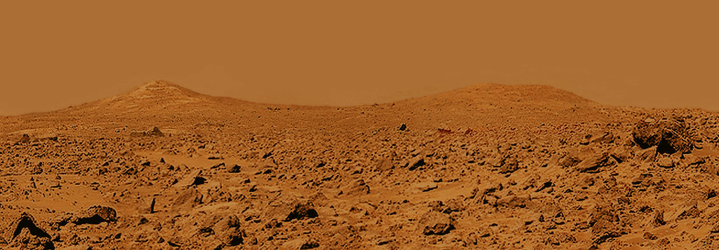
-------------------- |
|
|
|
|
Sep 16 2006, 05:08 PM
Post
#469
|
|
|
Member Group: Members Posts: 320 Joined: 19-June 04 Member No.: 85 |
Sorry to hear about your site, Ted. I'm glad you're uploading your images to Flicker, as your work is extremely good, unique and important. Thanks for the great images and keep 'em coming!

-------------------- |
|
|
|
|
Sep 16 2006, 05:27 PM
Post
#470
|
|
 Senior Member Group: Members Posts: 3419 Joined: 9-February 04 From: Minneapolis, MN, USA Member No.: 15 |
And I'll tell you, I *still* want to get over to those Twin Peaks and take a look at the big boulders that lie in the hollow between them.
That raises an interesting question. The rationale for the selection of both the Ares Valles and Chryse Planitia landing sites (MPF and Viking 1, respectively) was that each seems to lie in the midst of an ancient catastrophic outflow channel. The reasoning, as I understood it, was that these sites ought to 1) show signs of the water that once flowed there, and 2) have a lot of rocks on the surface that were transported there by the floods which created the outflow channels. As far as I know, no significant insights about the former presence of water has ever come from either site -- certainly nothing like what we've seen at both Meridiani and Gusev. Seems those forces left far more subtle clues in the outflow channels than in places where water once pooled and groundwater rose to the surface. So, reasoning path number one seems to have been a bust. And as for reasoning path number two -- yes, it's interesting to see a large variety of rocks. But they might have come from anywhere along the path of the ancient floods. Doesn't that really muddy the waters (so to speak) when it comes to geologic analysis? Without a context for where these rocks might have formed, don't we get a far-less-helpful set of results, in geological terms, than we would if we were exploring an area in which the surface rocks could mostly be traced back to processes that occurred in the local area? -the other Doug -------------------- The trouble ain't that there is too many fools, but that the lightning ain't distributed right. -Mark Twain
|
|
|
|
|
Sep 16 2006, 06:18 PM
Post
#471
|
|
|
Member Group: Members Posts: 688 Joined: 20-April 05 From: Sweden Member No.: 273 |
QUOTE (tedstryk @ Sep 14 2006, 04:06 PM) As many of you know, my website is gone, and I have not had time to rebuild. What was the URL? It may still be around at archive.org. tty |
|
|
|
| Guest_DonPMitchell_* |
Sep 16 2006, 06:50 PM
Post
#472
|
|
Guests |
QUOTE (tedstryk @ Sep 14 2006, 07:06 AM) As many of you know, my website is gone, and I have not had time to rebuild. Until I can, I am loading some of my images here. This is my favorite new image I posted. I'm sorry to hear about your website. I'm a huge fan of media3.net, if you are looking for a reliable host who have been in business for a long time. They offer Windows, BSD and Linux hosting starting at about $8/month. Beautiful image! |
|
|
|
|
Sep 16 2006, 07:06 PM
Post
#473
|
|
 Member Group: Members Posts: 656 Joined: 20-April 05 From: League City, Texas Member No.: 285 |
QUOTE (dvandorn @ Sep 16 2006, 12:27 PM) ... As far as I know, no significant insights about the former presence of water has ever come from either site -- certainly nothing like what we've seen at both Meridiani and Gusev. Seems those forces left far more subtle clues in the outflow channels than in places where water once pooled and groundwater rose to the surface. So, reasoning path number one seems to have been a bust. ... As I recall, Pathfinder did indeed see evidence of a massive flood event, evident in the alignments of the rocks and large scale ripple effects in the surrounding terrain, similar to some of the really big floods they've had in Iceland. The notion of the rocks being out of context is a valid perspective, however, and I agree that at this point it seems wisest to head for places where the rocks can be studied in the context where they formed. Personally I'd like to drop a rover into Hellas crater, which I gather is the lowest point on Mars and the only place where the atmospheric pressure is high enough to allow liquid water to exist. The orbittal pics do look pretty boring though, perhaps what you'd expect of a sea bottom, with the only flow features being near the rim. Perhaps a target for a future rover, I think that there are more interesting places to sent MSL. |
|
|
|
|
Sep 16 2006, 09:11 PM
Post
#474
|
|
|
Solar System Cartographer Group: Members Posts: 10146 Joined: 5-April 05 From: Canada Member No.: 227 |
dvandorn's question about Viking 1 and Pathfinder site selection raises interesting points. I'm paying a lot of attention to this now as I begin collectimg material for a future Mars atlas.
Viking 1... it was NOT sent to its landing site because it might show evidence of water flow. That was one point in favour of the Chryse site first chosen for Viking 1, but the very first orbit of certification images revealed erosional 'scablands' and similar terrain, nothing like the smooth surface expected from Mariner 9 images. The Viking site actually used was chosen because, after that scare, they wanted something very smooth, and imaging plus earth-based radar indicated that new site was fairly smooth. In addition, because it looked like a lunar mare, with small craters and wrinkle ridges, they THOUGHT they understood its origins well enough to predict what the rock population would be. Therefore the actual Viking 1 site was basically chosen because it looked like a lunar mare. There was a minor bonus, the Maja Valles floods might have wetted it a bit, though the site was beyond any geomorphological evidence for flow. Pathfinder was different. Here they went right back to the first Viking site... they key science instrument was APXS on the little rover. The best results would be had if, within the 10 - 20 m expected range of the rover, they could use APXS on rocks with different compositions. So they deliberately chose a "grab-bag" site which might put different rock types (deposited by the floods) within range of Sojouner. Land on bedrock, do one APXS, and you have nothing else to do. Here they might make multiple non-redundant measurements. Both sites delivered what was expected within reason, though they hoped for more variation in APXS results. The so-called evidence for flow at Pathfinder - imbricated boulders etc., is very weak. Almost every rock at the site is likely to be from local crater ejecta, not the original flow. It might be originall flow-deposited, but it's been reworked and redeposited by impact. Phil -------------------- ... because the Solar System ain't gonna map itself.
Also to be found posting similar content on https://mastodon.social/@PhilStooke NOTE: everything created by me which I post on UMSF is considered to be in the public domain (NOT CC, public domain) |
|
|
|
|
Sep 17 2006, 03:55 AM
Post
#475
|
|
|
Interplanetary Dumpster Diver Group: Admin Posts: 4404 Joined: 17-February 04 From: Powell, TN Member No.: 33 |
QUOTE (DonPMitchell @ Sep 16 2006, 06:50 PM) I'm sorry to hear about your website. I'm a huge fan of media3.net, if you are looking for a reliable host who have been in business for a long time. They offer Windows, BSD and Linux hosting starting at about $8/month. Beautiful image! I have a new host...the problem is that I haven't had time to set anything up. -------------------- |
|
|
|
|
Dec 30 2006, 10:37 PM
Post
#476
|
|
|
Interplanetary Dumpster Diver Group: Admin Posts: 4404 Joined: 17-February 04 From: Powell, TN Member No.: 33 |
I have been working with some of the Mariner-6/Mariner-7 images lately. The data is much poorer quality than I imagined - I always assumed that since Mariner 4 and Mariner 9 sent digital data, Mariner 6 and 7 did too. However, a shocking amount if the image data is analog.
Here is a mosaic I constructed using the south polar data. I do think that since the dataset does provide the earliest global mapping at resolution better than a few hundred km, as well as a closeup of the south polar region, the dataset will always have value in our baseline. 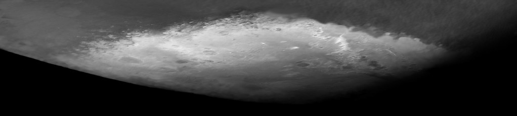 Here is the same view at full resolution, but this required much heavier jpeging. 
-------------------- |
|
|
|
|
Dec 31 2006, 02:08 AM
Post
#477
|
|
|
Solar System Cartographer Group: Members Posts: 10146 Joined: 5-April 05 From: Canada Member No.: 227 |
Very nice, Ted. Happy New Year!
Phil -------------------- ... because the Solar System ain't gonna map itself.
Also to be found posting similar content on https://mastodon.social/@PhilStooke NOTE: everything created by me which I post on UMSF is considered to be in the public domain (NOT CC, public domain) |
|
|
|
|
Dec 31 2006, 04:28 AM
Post
#478
|
|
|
Senior Member Group: Members Posts: 2511 Joined: 13-September 05 Member No.: 497 |
QUOTE (tedstryk @ Dec 30 2006, 02:37 PM) I have been working with some of the Mariner-6/Mariner-7 images lately. The data is much poorer quality than I imagined - I always assumed that since Mariner 4 and Mariner 9 sent digital data, Mariner 6 and 7 did too. However, a shocking amount if the image data is analog. You might be interested to read my summary of how the MM69 camera system worked: http://mars.jpl.nasa.gov/mgs/msss/camera/i...m7_imaging.html -------------------- Disclaimer: This post is based on public information only. Any opinions are my own.
|
|
|
|
|
Dec 31 2006, 01:53 PM
Post
#479
|
|
|
Interplanetary Dumpster Diver Group: Admin Posts: 4404 Joined: 17-February 04 From: Powell, TN Member No.: 33 |
QUOTE (mcaplinger @ Dec 31 2006, 04:28 AM) You might be interested to read my summary of how the MM69 camera system worked: http://mars.jpl.nasa.gov/mgs/msss/camera/i...m7_imaging.html Thanks. It really is amazing to see how far things have come! -------------------- |
|
|
|
|
Dec 31 2006, 07:56 PM
Post
#480
|
|
|
Senior Member Group: Members Posts: 2511 Joined: 13-September 05 Member No.: 497 |
QUOTE (tedstryk @ Dec 30 2006, 02:37 PM) I have been working with some of the Mariner-6/Mariner-7 images lately. Which reminds me: does anyone have access to this globe? http://libweb5.princeton.edu/visual_materi...s/hmc05.html#g7 It was drawn using Mariner 6/7 images and (I suspect) a good deal of imagination. I'd love to get a good set of photos of the entire surface. -------------------- Disclaimer: This post is based on public information only. Any opinions are my own.
|
|
|
|
|

|
Lo-Fi Version | Time is now: 19th April 2024 - 10:16 PM |
|
RULES AND GUIDELINES Please read the Forum Rules and Guidelines before posting. IMAGE COPYRIGHT |
OPINIONS AND MODERATION Opinions expressed on UnmannedSpaceflight.com are those of the individual posters and do not necessarily reflect the opinions of UnmannedSpaceflight.com or The Planetary Society. The all-volunteer UnmannedSpaceflight.com moderation team is wholly independent of The Planetary Society. The Planetary Society has no influence over decisions made by the UnmannedSpaceflight.com moderators. |
SUPPORT THE FORUM Unmannedspaceflight.com is funded by the Planetary Society. Please consider supporting our work and many other projects by donating to the Society or becoming a member. |
|


