Printable Version of Topic
Click here to view this topic in its original format
Unmanned Spaceflight.com _ MSL _ MSL EDL Hardware
Posted by: bigdipper Aug 7 2012, 06:17 PM
Looking at the HiRISE imagery of the descent stage, does the distribution of the debris field represent the disintegration of the stage from impact only, or is it possible that some or all of the 140+/- kilos of Hydrozine exploded and expanded the debris field? [I understand the darker albedo material is from below the surface]
Does the thin martian atmosphere contain enough oxygen to support combustion/explosion? [guessing No, but my chem is insufficient]
Were the hydrazine cells sufficiently designed to survive impact intact?
I couldn't find anything on the net or in the specs, any ideas?
Posted by: ugordan Aug 7 2012, 06:24 PM

No, but monopropellant hydrazine in the tanks is its own fuel and oxidizer.
Posted by: Drkskywxlt Aug 7 2012, 06:25 PM
Each ballast weighed 55lb, so those should make a decent dent in the surface.
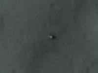
Suspicious smudges highlighted:
|
Posted by: Pando Aug 7 2012, 06:33 PM
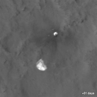
The dust cloud could have drifted somewhat since the crash. Looking at the crests of those black dunes, it appears that the prevailing winds are roughly north to south. If we're looking at west-northwest with the rear hazcam, I find it plausible that some drifting toward the left may have occurred due to wind.
Since we now have the direction roughly correct, it all depends on the exact timing of the images to really nail it down.
Posted by: dvandorn Aug 7 2012, 06:34 PM
The image of the descent stage impact site(s) is really, really interesting. First off, while everything sprays down in the direction of travel, there are very specific plumes angling off about 50 to 60 degrees on either side of the main motion vector. Looks a lot like the angle at which the opposite-side engine pods are mounted from one another.
Could the descent stage have hit the ground with engines running and flipped over, spraying a blast of exhaust ahead of it and along the angles consistent with their attachment to the frame of the stage? And then after hitting ground following the first flip, disintegrated and resulted in the long tongue of disturbance from the initial impact point to the final impact point?
Just random thoughts...
-the other Doug
Posted by: Greenish Aug 7 2012, 06:34 PM
From hirise I measure an azimuth of -71 deg for the DS impact. IF the rhaz is pointing exactly along the rover axis, then the centre of the rhaz frames should be at -66 (using rover azimuth 114 deg). But the cloud is left of centre frame. So using the above scale, I get the cloud to be between az -72 and -80 degrees. So a bit off. But the assumption of rhaz on axis could easily be out by a few degrees.
In fact, I'm way more willing to accept a few degree offset than a DD that magically appeared as we landed!
edit: that scale refers to the full res (1024 pix wide) image.
I was referring to the disturbed zone around the rover created by the descent stage hover as seen in HiRise image. Sorry if I was not clear; original post clarified.
Posted by: Doc Aug 7 2012, 06:38 PM
I don't know...

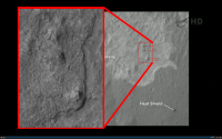
Here is a cropped up view.

|
Posted by: kwan3217 Aug 7 2012, 06:38 PM
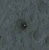
Suspicious smudges highlighted:
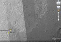
Google Mars had pre-landing hirise data yestetday, see if the spots are there then.
Posted by: Tesheiner Aug 7 2012, 06:40 PM
Suspicious smudges highlighted:
Too close to the landing site. Remember that the ballasts were ejected way before the heatshield and the latter is further away than the smudges. Those seem to be shadows of the terrain (see image from GE).
|
Posted by: ugordan Aug 7 2012, 06:41 PM
They are, that's terrain shadows.
Don't use screencaps off of NASA TV of HiRISE images reduced in resolution to hunt for ballast impacts. They are probably further downrange than the heatshield, anyway.
Posted by: Drkskywxlt Aug 7 2012, 06:42 PM
Hmmm...bottom/southern two look like shadows in that version. Top/northern ones I'm not sure.
Edit: Shadows it is!
Posted by: Skyrunner Aug 7 2012, 06:43 PM
Suspicious smudges highlighted:
Placed the larger tiff of the boxed section in the image...those smudges don't look like craters, more like small mounds. Shouldn't the 'ballast-crateters' be located more downrange?
|
Posted by: kwan3217 Aug 7 2012, 06:43 PM
Strictly speaking, monoprop doesn't even burn, it decomposes. In an engine, it is triggered by a metal catalyst. Is iron oxide an appropriate catalyst? If so, then I can see the tanks splitting on impact then the fuel igniting when it hits the dust.
Posted by: Explorer1 Aug 7 2012, 06:57 PM
When it comes to finding the ballast impacts, remember that Oppy found a bunch of meteorites, and purely by chance. In the coming months/years MSl will doubtless be traveling a long way, and in the direction of Mt. Sharp to boot. If they are found; I won't be surprised.
Posted by: Skyrunner Aug 7 2012, 07:05 PM
No, from my bare head you need a catalyst with iridium and/or ruthenium normally. Metals like cobalt, nickel or iron will speed up the decomposition but not nearly to the point of catalytic decomposition (only 10x to max 100 x compared to air). The catch here is that this gets highly uncertain when CO2, H20 or CH4 is present.... guess what's in the atmosphere of Mars;-) There is a similar issue with acidic stuff pressent.
Posted by: MahFL Aug 7 2012, 07:15 PM
I ask because if was to keep running until it ran out of fuel and it had 140kg left..
The DM was programmed to burn for 6 seconds, then cut off on the flyaway burn.
Posted by: Roby72 Aug 7 2012, 08:15 PM
As for searching the ballast impacts sites I suggest to subtract an HIRISE image of Gale which was taken before landing with the new one. Some geometrical correction (because of the incline of the new one) and hopefully equal lightning in both do the trick. Searching for changing parts must be much easier then...
just my 2 cents..
Rob
Posted by: DFinfrock Aug 7 2012, 10:17 PM
Since we now have the direction roughly correct, it all depends on the exact timing of the images to really nail it down.
Since the parachute landed generally south of the line of the other impactors, we can safely assume that the wind was from north to south, which might support that hypothesis of a drifting cloud of dust. But of course, the parachute was drifting with the winds above the ground. We don't know for certain that the wind at the surface was also from north to south.
David
Posted by: fredk Aug 7 2012, 10:43 PM
Right! I only meant that it was possible that we landed SE of an interesting area, like for example where the three terrain types meet. Then we might've had to worry about the DS debris if we wanted to check out that area.
Of course the odds of that were slim, and the primary goal is southwards.
Posted by: fredk Aug 7 2012, 10:48 PM
Posted by: elakdawalla Aug 7 2012, 10:59 PM
Note: dfinfrock is a http://www.nbcdfw.com/on-air/about-us/David_Finfrock.html in my hometown, Fort Worth, TX. He knows whereof he speaks when he talks about wind

Posted by: atomoid Aug 7 2012, 11:07 PM
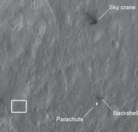
MRO really got http://www.uahirise.org/images/2012/details/cut/landing_site_annotated.jpg this time.
..looks like the http://www.uahirise.org/images/2012/details/cut/sky_crane.jpg
the heatshield http://www.uahirise.org/images/2012/details/cut/msl_parachute_heatshield.jpg!!
anyone know if there are plans to do any interplanetery rubbernecking? Oppy's heatshield I recall gave up some useful data.
click me: http://www.uahirise.org/releases/msl-descent.php
Posted by: bigdipper Aug 7 2012, 11:11 PM
Does the parachute act as a windsock and give us the surface wind direction at time of backshell/parachute impact?
The backshell comes to rest before the parachute which then settles on the ground downwind (S) indicating wind from the north at the surface at time of impact.
Posted by: MahFL Aug 7 2012, 11:12 PM
David
Don't forget the DS does a rather large avoidance maneuver to prevent the back shell/parachute from impacting the DS as it slows down.
Posted by: elakdawalla Aug 7 2012, 11:24 PM
Ah, good point. Still, one can deduce wind direction from the direction in which the parachute settled.
Posted by: erwan Aug 7 2012, 11:29 PM
Direction from backshell to parachute ; from NNE to SSW...
Posted by: Holder of the Two Leashes Aug 7 2012, 11:33 PM
Not knowing anything about the specific design, I'm wondering if the tanks needed to be breached in order for there to be a hydrazine release. Depending on the location of the valves, might it have been sufficient to rip off part of the plumbing to empty the tanks?
Posted by: fredk Aug 7 2012, 11:37 PM
Posted by: gallen_53 Aug 7 2012, 11:39 PM
There was some hallway gossip that the Skycrane would be carrying too much fuel when the tether was cut and could possibly be a threat to the rover due to exploding like a bomb after impact. Apparently it did blow up like a bomb but was far enough away to be a non-issue.
It would be cool to take a close look at the wreckage. However no one in their right mind would risk the rover by moving it close to the wreckage.
I'm hoping they will give the aeroshell a look. They gave the aeroshell wreckage a close look with MER-B.
Posted by: Explorer1 Aug 7 2012, 11:54 PM
By aeroshell do you mean the heat shield or the backshell? The latter was only given a distant glance across the horizon: see this thread:
http://www.unmannedspaceflight.com/index.php?showtopic=9
And yes, that's actually topic 9!
MSL's heat shield is huge, I sincerely hope it's given at least a quick once-over see to see its overall condition, and what was excavated (it is in Mt. Sharp's direction, so they might well pass it on the traverse.
Posted by: john_s Aug 7 2012, 11:54 PM
I seem to remember there was some concern that Opportunity's camera optics got contaminated during its visit to the heatshield, so they might be more careful with Curiosity.
John
Posted by: dmg Aug 7 2012, 11:55 PM
If I heard correctly today in the press conference they indicated that they would NOT approach any of the jettisoned items. Of course, everything is always open to change by the project. I'm absolutely certain though that they would not approach anywhere near the descent stage (skycrane) wreckage. DG
Posted by: NickF Aug 7 2012, 11:56 PM
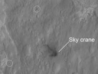
Are those three dark splodges in the crater NW of the SkyCrane impact site likely to be pieces thereof?
Posted by: gpurcell Aug 8 2012, 12:04 AM
That's my interpretation. There's actually a smaller object with four bounces south of there as well:
|
Posted by: James Sorenson Aug 8 2012, 12:08 AM
I'm not sure if this was discussed, I apologize if it has. There is a very obvious impact in the lower left if this image that I have highlighted with a box. I was thinking either from one of the masses or something that shot very far from the decent stage impact. Any idea's?
|
Posted by: nprev Aug 8 2012, 12:14 AM
Please post all comments regarding the ancillary hardware associated with the landing of Curiosity here; thanks!
Posted by: Explorer1 Aug 8 2012, 12:25 AM
James: if it is one of the ballast masses it's way out of place; those should all be downrange (east, towards Mt. Sharp). Looks too fresh and low-angle to be a tiny natural impact. Maybe worth examining with better Hirise imagery later?
Posted by: James Sorenson Aug 8 2012, 12:33 AM
Okay thanks Explorer1. The dark ejecta from that feature, seem's to line up with the skycrane impact, like it came from that general location. But you're right.
Posted by: fredk Aug 8 2012, 12:35 AM
Posted by: Mongo Aug 8 2012, 12:43 AM
If the DS exploded on impact with the Mars surface, could a stray fragment from the explosion be hurled this far? A hydrazine explosion might also explain the "dust cloud" we see in the rear hazcam images.
Posted by: fredk Aug 8 2012, 12:46 AM
Here are a couple more little dark splotches, that aren't on the old hirise imagery (GM):
|
Not as far afield as James's piece, though. I'm sure we'd see more with the full res hirise.
Posted by: Explorer1 Aug 8 2012, 12:48 AM
Yes, there's something to be said for a complicated EDL with lots of 'space junk'; it sure makes the slow early days of landing go by faster.
The question of visiting any of these things up-close, even the non-hazardous debris, is still really far off though, we should keep in mind.
Posted by: elakdawalla Aug 8 2012, 01:23 AM
I'm glad I didn't have time to write up that HiRISE image today. You guys are finding all kinds of goodies
Posted by: James Sorenson Aug 8 2012, 01:27 AM
WOW!! GM showes a rough distance of 2,300 feetOkay correction...2,700 Feet!!!!
Nevermind 
Posted by: dvandorn Aug 8 2012, 01:32 AM
Methinks if we ever use a skycrane type of landing again, we're going to have to program a little more smarts into the descent stage and have it either fly farther away or try to kill its velocity before it crashes. I shudder to think of what might have happened had one of those fragments of descent stage come back and whanged the rover real good...
-the other Doug
Posted by: MahFL Aug 8 2012, 01:39 AM
The question of visiting any of these things up-close, even the non-hazardous debris, is still really far off though, we should keep in mind.
A Mission manager said none will be visited, mainly as they were not decontaminated from earth organics as the rover was, so they don't want any chance of a erroneous organic result due to something transported from Earth.
Posted by: MahFL Aug 8 2012, 01:46 AM
John
Remember MSL's heat shield had a suit of senors built in to measure temperatures, g forces and how much material ablated away, so they will know how well it performed anyway.
Posted by: DFinfrock Aug 8 2012, 01:55 AM
The backshell comes to rest before the parachute which then settles on the ground downwind (S) indicating wind from the north at the surface at time of impact.
Good point bigdipper.
A line drawn through the locations of Curiosity and the heat shield should give a pretty good indication of the direction of entry. And the fact that the parachute and backshell landed south of that line confirms that the total of the wind vectors from the altitude at the time the Descent Stage separated from the parachute/backshell until it landed were generally from north to south. But that didn't prove that the surface winds were the same.
But your point about the backshell impacting first, followed by a slow settling of the parachure would certainly confirm that the surface wind was in the north to south )or northeast to southwest) direction.
David
Posted by: dvandorn Aug 8 2012, 02:36 AM
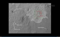
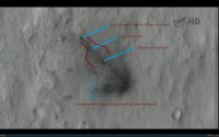
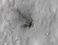
I've taken a closer look at the descent stage crash site, and I annotated it a bit to point out a few things I've noticed.
First off, I've drawn red arrows to point out what appear to be secondary impacts, mostly without any streaking of ejecta, just very dark spots where they don't appear to belong. I imagine a few of these are rock shadows, but most of them appear to be freshly disturbed soil. One area I really noticed was a small crater nearly under the stage's flyaway path that has four very dark spots in it. It's about the only sign of disturbance that is uprange of the crash site.
The green arrows point out four distinct plumes that fan out from what appears to be the main impact site. The northenmost of the four plumes are connected, almost just a small side-plume from a main plume. The other two plumes are very distinct and separate from the rest. Looks almost like the descent stage flipped over and hit the ground with the engines firing in the direction of flight, although I certainly don't insist on that interpretation.
Finally, there is this aureole-like feature just uprange of the impact point that I have rather imperfectly tried to outline in yellow. I see a very light disturbance in this area, much less darkened than the ejecta spray downrange of the impact. This uprange feature also appears to show radial spiking around its outside extent.
The combination of the four disturbed points in the crater uprange of the impact point and the plumes fanning forward from the impact point again makes me wonder exactly what happened as the stage came in for its crash-landing. I don't even know if it's possible for the engines to have been firing by the time it impacted; the fans I see may be separate ejecta events from each of the largest pieces of structure that hit at the main impact point. But it does look awfully suggestive.
-the other Doug
|
Posted by: fredk Aug 8 2012, 02:59 AM
And we can see glints off the descent stage debris!
http://mars.jpl.nasa.gov/msl-raw-images/proj/msl/redops/ods/surface/sol/00000/opgs/edr/rcam/RLA_397504876EDR_F0010000AUT_04096M_.JPG
edit: oops, should've posted in the hardware thread.
Posted by: jklier Aug 8 2012, 03:21 AM
Any chance HIRISE caught the skycrane phase of the landing? I'd love to see that as clear as the parachute image.
Posted by: B Bernatchez Aug 8 2012, 03:24 AM
-the other Doug
I think a better use would be to build in some hover capability and maneuverability prior to landing. With an estimated 140Kg of prop left, they should be able to add this in for the next attempt, whenever that might be.
Posted by: Explorer1 Aug 8 2012, 03:25 AM
If it had, we'd have seen it by now.
Posted by: elakdawalla Aug 8 2012, 03:25 AM
There was an interesting discussion about that on Twitter today between @burritojustice (I don't know who he is but I love his Twitter handle) and @HiCommander (Christian Schaller):
@HiCommander: Yes. Initial desire was to get both: chute sequence, sky crane sequence. However, HiRISE images are huge. (1/n)
@HiCommander: It takes several minutes to read out from instrument to s/c. 5-10 min typically. (2/n)
@HiCommander: So Not enough time to take chute image, read out, re-point MRO, start new slew, start taking crane image. (3/n)
@HiCommander: MSL team wanted chute image more than crane image, and that was that. (4/4)
@burritojustice: Tough decisions. Thanks for answering (and for taking the picture!) Until the next Sky Crane opportunity!
@HiCommander: You bet. WE actually wanted the crane. Spacecraft-on-parachute is so 2008 for HiRISE. Yawn.
@burritojustice: As I suspected.
Posted by: James Sorenson Aug 8 2012, 03:27 AM
Doug, according to the HiRISE images in GM, those dark spots in that crater in the lower right of your picture, were already there before landing.
Posted by: fredk Aug 8 2012, 03:33 AM
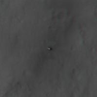
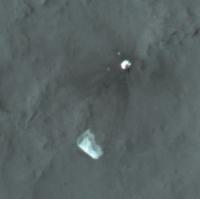
Here's a flicker gif between two R rhaz frames from sol 0, the first showing the dust cloud, the second showing glints off of what have to be DS debris:

|
So we can now see that the cloud is a bit to the left of the debris, which is consistent with a wind to the south.
But you can see something else, too. Compare the horizons in the two frames. The near horizons match up perfectly between the two frames on the left side. But, the right side of the near horizon is much less distinct, and lower, in the first frame than in the later frame. To me it looks like there is something obscuring the near horizon in the early frame - maybe dust kicked up during the descent!
Posted by: dvandorn Aug 8 2012, 03:34 AM
OK, kewl. Those spots just looked really fresh. Sorry I didn't run a comparison with the pre-landing image, there.
Makes you wonder what disturbed that crater, though... again, the disturbances look quite fresh, and the pattern looks quite similar to the one seen in the little crater just downrange of the main descent stage impact, where Occam's Razor would lead you to believe that the disturbances were indeed from the descent stage crash. Maybe a little ejecta from a nearby small impact knocked into the uprange crater sometime in the reasonably recent past?
-the other Doug
Posted by: James Sorenson Aug 8 2012, 03:43 AM
Fred that is interesting! Looks the same to me, I really hope we get the full-res picture of that plume to be able to tell for sure. The glint though in the higher res frame, looks to me though like a lens flare from the sun shining through the optics.
Posted by: elakdawalla Aug 8 2012, 04:04 AM
I thought "lens flare" too, when I saw it.
Posted by: dvandorn Aug 8 2012, 04:09 AM
Well, even if we steer wide and clear of the descent stage crash site, I imagine Curiosity will eventually gain enough altitude along the flank of Mt. Sharp to be able to look back and get a nice view of the crash site. That ought to clear up any mysteries as to what we might be seeing in that first clean hazcam.
So -- someone estimated that the hazcam images were taken 22 seconds after touchdown? I guess that means we couldn't have caught the descent stage in flight, so the RHA must be a post-crash cloud. Although I guess it depends on how long the thing would have stayed up in the air after its translation turn followed by six seconds of thrust.
-the other Doug
Posted by: Explorer1 Aug 8 2012, 04:18 AM
There's a tiny spot just to the right of the shield (in the full resolution linked above); is that just an artifact or real?
Posted by: fredk Aug 8 2012, 04:40 AM
I don't recall seeing glints like that on MER hazcams. Perhaps they're due to the lens covers.
Posted by: mcaplinger Aug 8 2012, 05:31 AM
I'm pretty sure that's a piece of crud on the sensor; I see one in the ground flats at about col 614 row 428.
Posted by: MarsInMyLifetime Aug 8 2012, 06:52 AM
I have a hard time getting my head around the interpretation of the fallen parachute as indicating wind direction. We know that this hardware hit at 200mph or so, and the inertia of the 100 lb chute would have had been barely influenced by sideways winds in the milliseconds it took to stream in after the lines went slack. We are used to seeing billowing material at 1 atmosphere on Earth, but on Mars parachute material would behave much more like the Apollo 15 feather drop. What seems more reasonable to me is that descent stage release induced random swinging of the backshell, and that the chute's direction is more due to its orientation at landfall than to winds. Every good party needs a loyal objector--I offer this thought to encourage not running too quickly with wind as a sole cause agent for all supposed observations.
--
Don
Posted by: Kaputnik Aug 8 2012, 07:07 AM
200mph was the speed of the whole spacecraft under parachute. The backshell alone being much lighter, it would have slowed considerably from this.
Your point may well stand, though.
Posted by: djellison Aug 8 2012, 07:13 AM
No - you're not accounting for the stack reducing in weight from 2200kg or so, down to 300 or so after the powered descent vehicle dropped out of the back shell.
It would have landed much much slower than 200mph.
Posted by: MarsInMyLifetime Aug 8 2012, 09:37 AM
I could not find a predicted impact velocity, but let's bring it down to 120-180fps--traveling roughly the length of the parachute per second. At backshell impact, the material is still going at that terminal velocity, so how fast can it decelerate in rarefied air, and can the windsock effect happen in that duration? I just suspect that the angle at touchdown matters more than wind in which direction a parachute lays out.
Posted by: Hungry4info Aug 8 2012, 02:22 PM
Marginally related, but now that we've firmly identified a spacecraft crash site on Mars, it's worth watching it for a while and seeing how long it takes to blend in with the terrain. It might inform searches for MPL.
Posted by: eoincampbell Aug 8 2012, 02:28 PM
We'll also see any shifting of the chute material in the upcoming HiRISE passes...
Posted by: fredk Aug 8 2012, 02:58 PM
Interesting thoughts, MarsInMyLifetime. If the backshell wasn't doing any significant swinging, then (assuming a constant wind direction all the way down) the 'chute should already be downwind of the backshell at backshell impact. So the 'chute should end up downwind. But if there was substantial swinging then I don't know...
Posted by: gpurcell Aug 8 2012, 03:24 PM
Given the extremely thin atmosphere on Mars I doubt that wind pressure could overcome (or even seriously diminish) whatever force vector the parachute centroid had following the impact of the backshell.
Posted by: ugordan Aug 8 2012, 03:25 PM
I think Phoenix already demonstrated after one Martian polar winter that trying to spot MPL is a lost cause.
Posted by: Explorer1 Aug 8 2012, 05:21 PM
They found the ballasts! See the press conf...
Posted by: JTN Aug 8 2012, 06:01 PM
Posted by: Oersted Aug 8 2012, 06:11 PM
...And well... The biggest visible opening in the dune field, going to the mountain, DOES take Curiosity exactly in the direction of the mass ballasts... Even though they are twelve kms away that might improve the chance of Curiosity paying them a visit.
Posted by: Explorer1 Aug 8 2012, 06:16 PM
Yeah, they're really not as out of reach as was implied; we all saw how saying 'never' went for the MERS.
Posted by: gallen_53 Aug 8 2012, 07:34 PM
The instrument package embedded in MSL's heat shield is called "MEDLI". Refer to the following if you want to learn more about it:
http://msl-scicorner.jpl.nasa.gov/Instruments/MEDLI/
For the Thermal Protection System (TPS) community, this is a Big Deal. Mars Pathfinder had an instrumented heat shield and the results were extremely useful in designing future heat shields. The folks behind MEDLI had to fight hard to get MSL's heat shield instrumented. MSL's Entry Descent and Landing (EDL) was the first in the history of Mars exploration where a heat shield's boundary layer went turbulent. This made designing the heat shield very tricky. The originally selected heat shield material SLA-561V was found to be inadequate due to the turbulent heating and had to be replaced with Phenolic Impregnated Carbon Ablator (PICA). PICA was first used for the Stardust reentry vehicle (fastest reentry in the history of Space Exploration). The Stardust aeroshell was NOT instrumented. This lack of instrumentation caused much weeping and gnashing of teeth in the TPS community and was a prime argument for instrumenting MSL.
Posted by: kwan3217 Aug 8 2012, 08:00 PM
Stardust was the fastest reentry at Earth, and I guess only entries at Earth can be called 're'entries, but the Galileo probe was far faster (~60km/s entry speed).
/pedantic
Posted by: charleski Aug 8 2012, 08:55 PM
I haven't seen anyone talk about this, and it wasn't mentioned in today's press conference, but forgive me if I've missed something.
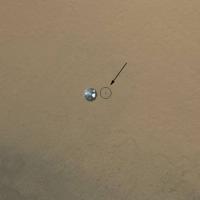
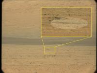
There's a dot off to the right side of the heat shield in the full res MARDI image that was released. It seems quite sharp and doesn't correspond to anything in the HiRiSE ground images, so must be related to the capsule. Anyone have a guess as to what it is?
|
Posted by: Kaputnik Aug 8 2012, 08:59 PM
There's a dot off to the right side of the heat shield in the full res MARDI image that was released. It seems quite sharp and doesn't correspond to anything in the HiRiSE ground images, so must be related to the capsule. Anyone have a guess as to what it is?
The shadow?
Posted by: MaG Aug 8 2012, 09:02 PM
There's a dot off to the right side of the heat shield in the full res MARDI image that was released. It seems quite sharp and doesn't correspond to anything in the HiRiSE ground images, so must be related to the capsule. Anyone have a guess as to what it is?
I was speculating today at Emily's blog about shadow, but in fact it is maybe nothing that a "bit of crud" on the detector.. We will see, when more fullres images are down.
Posted by: ugordan Aug 8 2012, 09:03 PM
I think it's a blemish in the camera.
Posted by: Ian R Aug 8 2012, 09:08 PM
Given the phase angle here, could it be a shadow cast by the heatshield?
Posted by: ugordan Aug 8 2012, 09:11 PM
A shadow would be placed pretty much in the middle of the opposition highlight on the ground.
Posted by: gallen_53 Aug 8 2012, 09:12 PM
There's a dot off to the right side of the heat shield in the full res MARDI image that was released. It seems quite sharp and doesn't correspond to anything in the HiRiSE ground images, so must be related to the capsule. Anyone have a guess as to what it is?
That would have been one of the nine separation (kick-off) springs that were around the explosive bolts holding the forebody heat shield to the afterbody that at the time was hanging from the parachute. Those springs can be seen in the wreckage of the MER-B heat shield. Those kick-off springs were a clever bit of engineering developed by Lockheed-Martin for Mars Pathfinder and used ever since. The Viking aeroshell used gas driven pistons to break the bolts holding on the forebody heat shield. The Viking approach was more costly and probably less reliable but had the advantage of not having lose junk flying about.
Posted by: elakdawalla Aug 8 2012, 09:12 PM
C'mon, guys, http://www.unmannedspaceflight.com/index.php?s=&showtopic=7401&view=findpost&p=187609. Please read all of the posts in a thread before you ask questions.
Posted by: gallen_53 Aug 8 2012, 09:27 PM
/pedantic
Yeah, Stardust was the fastest reentry at 12.45 km/sec [relative frame at 134.4 km], 12.78 km/sec [inertial frame]. The Galileo Probe was the fastest entry at 47.4 km/sec [relative frame at 450 km altitude], 59.83 km/sec [inertial frame]. The Galileo Probe's entry was ridiculously difficult (almost as crazy as MSL and the Space Shuttle) and only possible because carbon-phenolic was used as the thermal protection system (TPS) material and Jupiter has a hydrogen-helium atmosphere. If the Galileo Probe had hit the Earth's nitrogen-oxygen atmosphere going at 47 km/sec, it would have vaporized in a flash. Likewise if the Galileo Probe had hit the Earth's atmosphere going at Stardust's speed, very little of the heat shield would have ablated (kinetic energy scales as velocity squared). There's been some conversation about doing Saturn return reentries at 16 km/sec. When TPS guys hear that sort of talk, they smile and quickly change the conversation. We could probably do it if someone was willing to invest $300 million dollars on new TPS technology (yeah right, that's going to happen some time soon).
Posted by: charleski Aug 8 2012, 09:33 PM
Ah, sorry, I thought he was talking about something else. MARDI has an aperture of f/3 though, so dirt on the actual sensor wouldn't be so well-defined (and I assume the sensor is sealed), but he probably meant debris on the front element.
Posted by: MoreInput Aug 8 2012, 09:39 PM
The keys to start the Rover ...

Posted by: Bunker9603 Aug 8 2012, 09:55 PM
Right above your post gallen-53 gave this explanation:
So is it "crud" or one of the springs?
Posted by: elakdawalla Aug 8 2012, 10:16 PM
It will be very simple to answer that question as soon as another full-res raw frame is posted. If its position doesn't change, it's crud.
Posted by: EdTruthan Aug 8 2012, 10:29 PM
I recently found the forum here and have to say i've enjoyed the great amount of talent, knowledge, and enthusiasm. Kudos toall. Excellent stuff. Wife thinks Mars is quite a bit less exciting than me so it's good to have some company here...
Still fascinated by the skycrane impact. In an effort to get a grasp on it, I've carefully overlayed the HiRISE close-up into GM, and by my measurements from impact to farthest visible dispersal it's over 290 feet. Here's the impact overlayed on the field at Buccaneers Stadium for some perspective. That looks like it made quite a stir. GM also says the heading from Curiosity to skycrane impact is 289 degrees. So that's 5 degrees left of the centerline of the rear hazcam (294 degrees or so), making it just left of center, exactly where the "impact cloud" is seen in the hazcam shots. Now I'm onto some quick calculations of how high the cloud it was based on a triangulation of the distance and elevation of the crater rim in the background vs. the impact distance...

|
Posted by: DFinfrock Aug 8 2012, 10:44 PM
Welcome to umsf! That's a great way to illustrate the distance covered by the scattering of debris from the impact of the Descent Stage.
Posted by: fredk Aug 8 2012, 10:57 PM
Great illustration, EdTruthan!
I'll look forward to your calculations as a check on http://www.unmannedspaceflight.com/index.php?s=&showtopic=7397&view=findpost&p=187462
Posted by: Gladstoner Aug 8 2012, 11:18 PM
.
Posted by: gallen_53 Aug 8 2012, 11:30 PM
There would have been lose springs flying about the jettisoned heat shield. The only question is whether they could have been resolved by the camera.
For no good reason, I've attached a picture of the MSL aeroshell while it was still at JPL. One of the heatshield's engineers was Robin Beck. She's standing underneath the aeroshell. A good looking JPL technician is standing next to her. Note the six ballast ports in the after body above the heat shield. Also note the different color of the TPS material from previous heat shields. All previous American Mars aeroshell heat shields used SLA-561V which had a more reddish color. MSL used PICA.

|
Posted by: Ian R Aug 8 2012, 11:47 PM
It is, indeed, crud:

|
Posted by: gallen_53 Aug 8 2012, 11:58 PM
|
|
Case closed.
Now if we look inside the nine insets on the heat shield can we see if the springs are still there? I could not tell. Maybe if we look more carefully, we'll find the springs falling next to the heatshield. It's possible that the springs don't fly out until after the heatshield whacks into the Martian surface.
Posted by: Oersted Aug 9 2012, 12:36 AM
DPReview interview with Mike Ravine of Malin Space Science Systems about Curiosity's cameras:
http://www.dpreview.com/news/2012/08/08/Curiosity-interview-with-Malin-Space-Science-Systems-Mike-Ravine
Posted by: mcaplinger Aug 9 2012, 12:41 AM
If it's not crud on the sensor, then by an amazing coincidence it's at exactly the same pixel coordinates as a feature I can see in the pre-delivery flat fields taken back in 2008.
And yes, pieces of debris on the sensor are this well-defined.
Posted by: eoincampbell Aug 9 2012, 01:19 AM
I find the lack of dust on the http://photojournal.jpl.nasa.gov/tiff/PIA16018.tif quite surprising given what the HAZCAMS initially saw...
sorry, wrong thread
Posted by: StephenGFX Aug 9 2012, 02:13 AM
Indeed we can!

|
Posted by: charleski Aug 9 2012, 02:52 AM
And yes, pieces of debris on the sensor are this well-defined.
Fair enough. I was surprised that it's so sharp at f/3, but looking through the 2001 JGeophysRes paper I see that the MARDI used on the Polar Lander didn't have a bandpass filter. Is the sensor completely naked with no bandpass or birefringent filters?
Posted by: Burmese Aug 9 2012, 03:09 AM
I know they have built up in advance a list of what images to download and in what order but I would imagine at this point that the full res of that 1st rear hazcam would have been moved up in the queue so they could better tackle the question of whether it actually caught a view of the descent stages' crash or lingering dust cloud. Anyone know whether that image is due for transmit home anytime soon?
Posted by: djellison Aug 9 2012, 03:22 AM
I asked Justin Maki about that. Sadly we're not going to get that rear hazcam at higher res than 256x256. It had to be processed very quickly by the vehicle in a hope to make the end of that first UHF pass and thus (much like the DIMES images of MER) was downsampled at acquisition. A full size version never existed in rover flash memory.
Posted by: mcaplinger Aug 9 2012, 03:25 AM
About the only thing that the MSL MARDI has in common with the MPL/PHX MARDI is the name.
The MSL MARDI has a bandpass filter (minus blue/IR cut) as a coating on one of the optical elements. The sensor has microlenses and the bayer pattern color filter array, but since any contamination is sitting right on top of those (only a few microns above the photosites, I would guess) the f/cone really doesn't matter very much.
Posted by: elakdawalla Aug 9 2012, 06:04 AM
http://www.lpi.usra.edu/meetings/lpsc2009/pdf/1199.pdf
Posted by: djellison Aug 9 2012, 07:04 PM
Just thought I'd tell you - I showed this to Adam Steltzner - he LOVED it - absolutely loved it! Much kudos
Posted by: gallen_53 Aug 9 2012, 07:30 PM
|
|
I just saw a high resolution image at work of the jettisoned heat shield and could count all 9 springs still attached to the heat shield. Apparently the springs do not fly out until after the heat shield impacts the Martian surface.
Posted by: charleski Aug 9 2012, 07:54 PM
The MSL MARDI has a bandpass filter (minus blue/IR cut) as a coating on one of the optical elements. The sensor has microlenses and the bayer pattern color filter array, but since any contamination is sitting right on top of those (only a few microns above the photosites, I would guess) the f/cone really doesn't matter very much.
Thanks very much! That does indeed explain things. I guess I heard Mike Malin talk about it being a standard Bayer sensor so often that I assumed it also had the chunky package filters that go on earth-bound cameras.
If anyone's interested, the most detailed article I could find about the cameras is http://rd.springer.com/article/10.1007/s11214-012-9910-4 one about MAHLI from Space Science Reviews, which is open access so you don't have to jump through hoops to read it.
Posted by: propguy Aug 9 2012, 10:52 PM
Sorry to bring up along dead portion of this thread, but as a propulsion engineer I felt I had to comment on this above statement (took two days to get my email confirmed so I could post though, therefore this shows up much later in the thread). Hydrazine is a monopropellant and thus has no oxidizer (but is a great propellant to use with LOX too). It is a highly energetic molecule that can create quite an exothermic reaction when flowed through the right catalyst (Iridium is the main one used, but the specifics of that mix and structure is proprietary to each thruster manufacturer). That reaction is two phase to 1st dissociate the N2H4 into H2 and NH3 and then to continue to break the NH3 into H2, N2, and residual NH3 (thus getting lower molecular weight to get better exhaust velocities and thus ISP).
As for the descent stage it would be expected that the prop tanks would rupture. I do not remember the exact pressure values but they were pressurized in the range of 700-800 psi and that would create quite a event even without propellant (i.e. even if they were filled with water they would explode due to the high pressure gas expansion as they ruptured). A good example of this was the 2004 Armadillo rocket crash where they ran out of fuel. The empty but pressurized tank launched itself very high after hitting the ground. Since the weak link in a tank is the attach points or the inlet/outlet, it is possible that happened here too (i.e. that tanks flew one more time) and that is why there are multiple impact points in the HIRISE photo. Unless there was something that could rapidly catalyze the hydrazine or some oxidizer (both highly unlikely) the hydrazine did not add to the explosion at rupture. Hydrazine is a great solvent for Kapton though (wiring and thermal blankets plus others things use Kapton) therefore I doubt they will drive near the remains to prevent any contact and damage (I have seen hydrazine take out wires and blankets when a system failed on-orbit). On Phoenix the program and scientists were so scared of hydrazine leakage if the tanks every cycled between freeze and thaw that we had to add a vent pyro to depressurize the tanks on landing. It was great watching the EDL on-line last Monday, having been there for Phoenix. Outstanding job MSL prop!
P.S. I have lurked in this forum for years, but posting is not my thing unless I can add something useful (hope I did today). The work done on Phoenix EDL to recreate the dynamics was very good. I hope that can happen again here for MSL.
Posted by: elakdawalla Aug 9 2012, 10:57 PM
This forum is all about SNR, and your first and only post had exceedingly high SNR. Thanks and welcome! It hadn't occurred to me that the tanks might explode simply due to the pressure they were under, but now that you mention the Phoenix prop vent I remember that and it makes sense.
Posted by: Zeke4ther Aug 10 2012, 02:28 AM
Thank-you for a very informative post! Welcome to UMSF
Posted by: EdTruthan Aug 10 2012, 07:43 PM
I'll look forward to your calculations as a check on http://www.unmannedspaceflight.com/index.php?s=&showtopic=7397&view=findpost&p=187462
FredK, your estimate of 70-80 meters for the height of the DS impact plume estimate is surprisingly consistent with what I got using a line-of-sight estimate based on the known distance and height of the crater rim seen in the background. I came up with almost exactly 80 meters. The methodology I used is illustrated in the attached diagram. Granted, the host of potential variables in this technique are clearly obvious and many, but the biggest one, that of having relatively level ground to both target objects is fortunately not at all bad at all in this case. To the rear left of Curiosity there is a slight rise, but from what I can tell from the images thus far obtained, the line-of-sight to the crater rim directly behind Curiosity (at a 294 degree heading) is a relatively level and unobstucted shot to the foothills. And it helps too of course that the hazcam is relatively low to the ground. Accurate or not, it's certainly worth noting that we both came up with similar numbers.

|
Posted by: Pando Aug 10 2012, 09:26 PM
I don't know if this has been discussed before, but looking at the MARDI descent movie, I realized that the heat shield impact area is visible for the MARDI camera for a full 1 minute and 8 seconds after heat shield separation. It leaves the frame for 7-8 seconds and then comes back into view for a few more seconds.
I was thinking that the heat shield impact event might be visible in higher resolution MARDI images once they are downloaded.
Does anyone know what the estimated descent time was for the heat shield before impact?
Posted by: walfy Aug 10 2012, 09:54 PM
Never thought of that possibility! I would assume that there is a very good chance that at least the darkened impact site is visible on some frames since it is not so far from the landing area, and somewhat less of a chance that the impact itself was captured since it might have occurred while the lander was still pretty high. Either case, this will be exciting to explore when the full res's come down!
Posted by: imipak Aug 10 2012, 11:35 PM
Here's the video of that Armadillo accident; after the impact, the pressurised tank takes off like a Johnny Wilkinson penalty kick:
http://www.armadilloaerospace.com/n.x/Armadillo/Home/News?news_id=272
(Links are at the bottom of the page.) The images of recovered hardware and holes in the ground give a vivid impression of how the descent stage impact and debris spray features visible in the HiRISE image may have formed. This tank was only(!) at 180 psi.
Posted by: nprev Aug 11 2012, 12:37 AM
Very good http://www.aviationweek.com/Article.aspx?id=/article-xml/AW_08_13_2012_p24-484494.xml&p=1 article about EDL; lotsa numbers & other tidbits of interest!
EDIT: MOD HAT ON: Especially for our new members, please remember to read the Forum Rules section very carefully before commenting. In this case, I would strongly recommend avoiding any discussion of budgets & future missions. The actual landing data is fascinating.
Posted by: djellison Aug 12 2012, 07:35 AM
I thought this might be the case based on Navcam, but it looks like none of the hardware is visible in the first full frame MastCam images. Hopefully we'll at least find a local topographic high to get a shot of the descent stage before heading East and South to the science!
D
Posted by: Explorer1 Aug 12 2012, 07:56 AM
Yes, the horizon is surprisingly close in some directions, especially to the south (below the rim in the newest shots). We're not in a depression per se, but this isn't a hilltop either.
I'm hoping for the heat-shield myself. Largest ever sent to another planet? It would be a missed opportunity to see how it fared. Better than Genesis at least....
Posted by: djellison Aug 12 2012, 06:42 PM
We wont need to visit it to see how it performed - MEDLI did that for us. It would be a nice visit though - I agree
Posted by: dvandorn Aug 12 2012, 06:58 PM
Question -- is there anything about the composition of the ablative on this heat shield, which does differ from previous Mars lander heat shields, that would make the possibility of contamination to the rover greater than that for, say, Oppy visiting her heat shield? Or lesser?
-the other Doug
Posted by: djellison Aug 12 2012, 07:10 PM
This one is PICA. Phenolic impregnated carbon ablator.
Clue's in the title really. I wouldn't want to see a MER like approach.
Posted by: EdTruthan Aug 12 2012, 07:51 PM
The area of the heatshield impact appears to be clearly visible from the elevated postition that MSL resides but the details of whether the heatshield or its impact scars can actually be glimpsed is hard to discern at the current resolution level of the latest pics. There appears to be "something" there though. From the HiRise close ups it appears to have impacted on the east slope of a small crater so I've been looking to see if anything might be in evidence. Though the pixel resolution at this range is frustratingly poor, using a line of sight estimate based on a distinctive "crescent shaped rock formation" in the dune field narrowed down the azimuth range to look. The HiRISE close-up of the impact area provides additional detail of distinct rock features very close to the Heatshield that appear to be quite consistent with what can be seen from the perspective of Curiosity especially a "big rock" just to the SW and a group of boulders strewn around a small crater directly to the south. See the attached graphic for more. Might be a fantastic target for a Mastcam 100 full telephoto test ay? Mastcam 100 has a 2.9" per pixel resolution at 1Km and the heatshield is only 1.5km away...

|
Posted by: Explorer1 Aug 12 2012, 08:12 PM
I think the direction is spot-on, but I think there's plenty of topography in the way before we see the heatshield itself.
Posted by: Stellingwerff Aug 12 2012, 08:29 PM
|
|
Brilliant presentation! It makes a convincing story.
Posted by: EdTruthan Aug 12 2012, 10:52 PM
Yup, I tend to agree as it clearly landed in a small depression. Still, as it looks to be quite a bit to the far slope of that crater, the chance that some impact disturbance toward the upper rim might be discernable by MC 100 isn't completely out of the question I suppose. It's interesting to note (unless my math is wrong), how Mastcam 100 may render images of a "heatshield sized" object at that distance though:
Heatshield: 4.5 meter diameter
Mastcam 100 max resolution: 2.9" (7.366 cm) per pixel at 1km OR 7.366 x1.5 = 11.049cm per pixel at 1.5km
Then, 450cm / 11.049 = 40.72767 pixels
... i.e a heatshield diameter of 41 pixels or so at best (photo below). Not too shabby!

Without doubt this could image the backshell and parachute just over the rise to the south very well and they're much closer. Can't wait to see the MC 100 in action on distant obects!

Posted by: Tom Tamlyn Aug 14 2012, 03:52 AM
The Aviation Week EDL article http://www.unmannedspaceflight.com/index.php?s=&showtopic=7401&view=findpost&p=188148 is complemented by Craig Covault's excellent http://www.americaspace.org/?p=23509 for AmericaSpace.
Posted by: vikingmars Aug 14 2012, 11:04 AM
Yes ! Great article BUT its figures are in "lbs" and "feet"... a real shame for AWST which presents itself as a worldwide magazine (I'm a subscrber to it and I really mean it).
Also, I'm no sure that this would please NASA which tries always its best to show that it integrated well the Metric System for its Mars program since the loss of the the "Mars Climate Orbiter" ("MCO") mission in 1999. The best way, if AWST cannot switch easely to the Metric System for its readers for the rest of the world, would be to have the US Imperial figures translated into the Metric System between brackets.

Posted by: MahFL Aug 14 2012, 11:35 AM
""You can think of it as a rocket-powered helicopter that will hover and then lower MSL to the surface on a harness called a bridle," says Doug McCuistion.
"It lands on its wheels and as soon as it puts its mast up, it's ready to go."
Well not exactly true, lol. 
Posted by: Zeke4ther Aug 14 2012, 04:46 PM
I very much agree with you vikingmars, but I also think NASA needs to do a better job. Part of it's mandate is to educate the public and one way would be to expose the American public more to the Metric System. But they have not been doing a particularly good job with MSL, given how popular it has been. I find frustrating how, much of the material presented and many of the presenters still using the Imperial system, when data was being presented.
NASA is squandering a brilliant opportunity while interest is still high.
Posted by: Hungry4info Aug 14 2012, 05:12 PM
New MRO image of MSL.
http://www.nasa.gov/mission_pages/msl/multimedia/pia16057.html
Posted by: Stu Aug 14 2012, 05:18 PM
I think NASA has much more important things on its mind, such as checking out and driving a multi billion dollar rover on an alien planet. Not sure many people care about the whole Metric v Imperial thing, to be honest.
Posted by: dvandorn Aug 14 2012, 05:22 PM
Agreed, Stu. Besides, it is *not* part of NASA's mission to drag the American people, kicking and screaming, into using the metric system. That's not an education issue, it's a conversion-of-faith issue...
-the other Doug
Posted by: djellison Aug 14 2012, 05:54 PM
In the new MRO image, that has color over Curiosity itself - you can not only see the plume impingement dust removal - but also a bias to the ESE as a result of the descent stage turning to flyaway WNW
(added an anim gif showing the various parts of the impingement)

|

|
Posted by: mcaplinger Aug 14 2012, 06:04 PM
I grow tired of MCO being used as the poster child for the evils of imperial units. The unit conversion problem was merely the root cause in a long chain of mistakes and missteps, technical and organizational, which could and should have been caught and fixed.
Posted by: djellison Aug 14 2012, 06:05 PM
I think the point Stu was making in post 133 is that this isn't the time or place for such a discussion. Period.
And with that the Imperial\Metric discussion is closed here. Any further comments around Imperial vs Metric measures in this thread will be deleted. Admin.
Posted by: elakdawalla Aug 14 2012, 06:19 PM
Thanks for the gif!Posted by: RoverDriver Aug 14 2012, 07:14 PM
(added an anim gif showing the various parts of the impingement)
You can also see that the mast is up, just in case the NAVCAMs and MASTCAMs we received were not a good indication of that event ;-)
Paolo
Posted by: EdTruthan Aug 14 2012, 10:20 PM
Hmmm... wow... could MARDI have inadvertantly "filmed" the timing and behavior of the descent stage impact?!
I confess I probably watch too much "Forensic Files" and it's certainly a trivial matter at this point compared to to the vast scientific ocean about to be embarked upon but...
Has ayone else noticed this? In the post-landing MARDI footage of the ground under Curiosity there's some interesting phenomena to be observed in the 2 minutes after landing. After skycrane flys away, and the dust settles enough for the narrow sun beam to be clearly evidenced on the ground, the sun beam suddenly goes distincly dark again and then slowly increases back to normal. The event happens around 43 seconds after touchdown and extends from about frames 785 to 900, or just over 30 seconds of time. As it turns out the rear hazcam photo of the impact plume, taken at 15:18:38, corresponds with the MARDI time stamp of frame 771, just 3.5 seconds before the "darkening" event. Could this indicate that the plume imaged by the hazcam at frame 771 continued to grow high enough in the next few seconds to visibly darken the area around Curiosity? If this is indeed the case, perhaps the MARDI images offer some evidence of the plume's relative longevity and even perhaps it's height based on the sun position at the time.
That said, an EARLIER "darkening" event similar to this one ALSO occurs between frames 714 to 747 (8.25 second duration) and slowly lightens until the frame 785 darkening. In addition, this event is PRECEEDED by a noticible "spike" in brightness centered around frame 699 (which is 22 seconds after touchdown). Which brings up the question of when the Descent Stage actually impacted vs. whether the event captured by the rear hazcam could have been a SECOND event, i.e. one of the "bouncing debris imacts" evidenced in the HiRISE close-ups that occurred up to 88 meters away. The sky in the rear hazcam photo is quite hazed over at the time and the crater rim for some distance around the plume is barely discernable. Certainly some airborne dust is still lingering from the landing at Curiosity's location but to my eye the forground still looks relatively clear compared to the air around the more distant vicinity of the plume. Could that be the airborne residue of the FIRST impact (i.e. at 22 seconds)?
Also, does anyone know if telemetry data from the descent stage was actually recorded after separation from Curiosity? Because I remember the time of descent stage impact being estimated at a bit over 20 seconds in press releases before landing and then at one of the post-landing press conferences hearing they'd updated it to over 40 some seconds after touchdown and thinking "that's seems way to long to fly a mere 630 meters..." I assumed the 40+ second assumption was based on the hazcam plume photo timestamp, naturally an irrefutable piece of evidence right? But could the MARDI frames indicate evidence for two imact "events", and the hazcam imaged the second one? The two "darkening" events are separated by roughly 15 seconds or so. Might that be about right perhaps for one or several of the hydrazine fuel tanks to bounce high and down range, and ultimately rupture just before the hazcam photo corresponding to MARDI's frame 771?
Two alternate theories of the phenomena of course are that differingly dense clouds of dust were still settling at or blowing about the landing site, OR that MARDI was automatically seeking to adjust aperature settings, the likelyhood of which could be answered by the imaging team of course.
In any case, here's a (thumbnail sized) video that starts at frame 612 (touchdown) and extends till all the "events" are well done (at frame 1100). Best viewed in a dark room of course. It's rendered in real time at 4fps. White levels have been batch-bumped very slightly in ALL the frames to bring out some sun beam detail, otherwise there's been no alteration of the images. Individual frame numbers have been added at the lower left for reference.
It'll be interesting to look at this segment when a FULL RESOLUTION version is available.
http://www.edtruthan.com/mars/MARDI-Frames-612-1100.mp4
Posted by: climber Aug 14 2012, 10:50 PM
A following remark to your post Ed, I guess that we'll be able to see the shadow of Curiosity as well as the Skycrane on final approach a bit like what we used to see on Moon landings like Apollo 11 but much shorter. Would be nice though
Posted by: djellison Aug 15 2012, 12:07 AM
No - none.
Posted by: markril Aug 15 2012, 02:44 AM
Hi, I'm a first time poster here, but sometimes lurker. I had prepared a few slides of how the dust cloud recorded in the initial rear hazcam images might be interpreted as the sky crane crash - this was around the same time the MSL team announced they had come to the same conclusion. My posting priviledges weren't enabled until today and I debated posting these but thought they might still be of some use.
In the image taken right after touchdown you can see the sky crane dust cloud but either the kicked up dust or the low (downsampled) resolution makes it difficult to see the background peaks. Lining up one of the subsequent images where conditions were clearer and at full resolution you can make out a couple of recognizable peaks:

|
Correlating the peaks with the dust cloud in Google Mars, the center of the dust cloud has an azimuth of 283 degrees while the sky crane is located at about azimuth 289 as indicated by the "crime scene" images taken by HiRISE:

|
Given the way the parachute landed to one side of the back shell, it seemed plausible a slight breeze was responsible and this is consistent with the dust cloud appearing to the south of where the sky crane impacted:

|
On the above map, the center of the dust cloud measures 75 meters from the sky crane impact site and at the time this seemed quite plausible to me.
Anyway, great site and I hope to be able to contribute in a more timely manner in the future.
Mark
Posted by: meraero Aug 16 2012, 03:05 AM
A bunch more full-frame MARDI images are down. I was following the HS and you can see the "splat" in this image (small dark smudge bottom center):
http://mars.jpl.nasa.gov/msl-raw-images/msss/00000/mrdi/0000MD9999000358E1_DXXX.jpg
The nearby thumbnails all appear to show this area. Once all the fulls are down, we should be able to nail the impact time. We will have great data to measure the HS drag from these images.
Posted by: Explorer1 Aug 16 2012, 04:24 AM
Oh wow, that will just whet our appetite for the complete full-res that much more.
Posted by: ChrisC Aug 16 2012, 05:34 AM
Being discussed in the landing thread. http://www.unmannedspaceflight.com/index.php?showtopic=7397&view=findpost&p=188749.
Posted by: climber Aug 22 2012, 12:46 PM
I think I red all the discussions since landing, so, forgive me if this has been posted and didn't see it.
On the same HiRise picture of MSL under parachutte, the heatshield is also visible: http://a35.idata.over-blog.com/3/69/76/43/Satellites/MSL/MSL---MRO---Bouclier-thermique---Parachure---Hirise.jpg
Posted by: Paolo Aug 22 2012, 12:57 PM
it's the heatshield, not the backshell. the backshell is still attached to Curiosity
Posted by: climber Aug 22 2012, 12:59 PM
Thanks Paolo, now corrected.
Posted by: RoverDriver Aug 22 2012, 02:51 PM
I hope not!

(the other) Paolo
Posted by: Paolo Aug 23 2012, 09:02 AM
what I meant was: the backshell is still attached to Curiosity in the MRO picture
Posted by: KrisK Aug 25 2012, 12:42 AM
Not sure if same has already been posted.
Took: http://www.uahirise.org/hiview/
Loaded ESP_028335_1755_RED.JP2: http://hirise.lpl.arizona.edu/ESP_028335_1755
Looked at MSL hardware...
...and was amazed IMHO heat shield does not look that bad.
http://www.flickr.com/photos/55907406@N08/7854072320/sizes/c/in/photostream/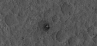
http://www.flickr.com/photos/55907406@N08/7854073020/sizes/l/in/photostream/
http://www.flickr.com/photos/55907406@N08/7854074646/sizes/l/in/photostream/
Posted by: elakdawalla Aug 25 2012, 12:56 AM
I had done that, but looked at the "merged RGB" product, and it was only after I'd identified all the hardware and made images and thumbnails that I found out that the merged products are posted at reduced resolution (50 cm/pixel) instead of the full 25 cm/pixel. And I haven't had time to get back to the full-resolution data. Thanks very much for posting these. You're right, the heat shield looks quite good.
There was another HiRISE taken 2 weeks post landing, right? Have they posted that one yet? It was supposed to be better than the EDL+6 one because shot more nadir.
Posted by: Hungry4info Aug 25 2012, 02:15 AM
Awesome images! But are you not forgetting the star of the show? Where is MSL? 
Posted by: KrisK Aug 25 2012, 10:29 AM
Well..I intentionally omited Her due to this:
http://www.nasa.gov/images/content/676478main_pia16057-full_full.jpg
published earlier.
Posted by: Hungry4info Aug 25 2012, 01:36 PM
Gotcha. It wasn't clear to me that you wouldn't be able to get a better image.
Posted by: Astro0 Aug 25 2012, 01:44 PM
Some obvious movement of MSL's parachute between the HiRise images.

|
Posted by: meraero Aug 27 2012, 03:02 PM
Took the file KrisK showed us (great pics of the hardware btw) and noticed something else. I don't think this has been pointed out by anyone yet. Looks like something got thrown really far from the DS impact site (farther than the DS traveled during "flyaway" from the Curiosity).
http://i1165.photobucket.com/albums/q593/meraero/HiRISE/DS-impact-site2.jpg
I looked within this range in other directions and didn't see anything. Looks like it WAS a pretty big boom in the rear hazcam image.
Posted by: fredk Aug 27 2012, 03:21 PM
Yep, that was http://www.unmannedspaceflight.com/index.php?s=&showtopic=7401&view=findpost&p=187555 More scattered debris in http://www.unmannedspaceflight.com/index.php?s=&showtopic=7401&view=findpost&p=187565
Posted by: belleraphon1 Aug 31 2012, 06:28 PM
Curiosity from MRO image taken August 17th released August 31 2012 interesting that Curiosity is a bit harder to see than MER rovers. MER have that triangular shape. To me they are easier to spot
http://mars.jpl.nasa.gov/multimedia/images/?ImageID=4602
http://www.uahirise.org/ESP_028401_1755
Posted by: atomoid Aug 31 2012, 07:20 PM
yows! "The new dark spots (left side) created streaks radial to the descent stage impact site, and may be from far-flung rocks or objects associated with the impact."
looks like MSL was 'within range' of a rather large piece of that debris..
Posted by: Doc Aug 31 2012, 09:23 PM
looks like MSL was 'within range' of a rather large piece of that debris..
I don't MSL was in any immediate danger (other than the gravel kicked up during landing) wrt the descent stage as any material kicked up by the impact would have taken the direction of momentum of the descent stage i.e. away from MSL.
Posted by: john_s Aug 31 2012, 09:47 PM
...except that the stray fragment that made the impact in the lower left of the image flew off at a rather large angle to the momentum direction, which is part of what makes it scary. While the danger to the rover was small, I suspect that if this landing technology is used again, there may some attention given to improving the safety of the skycrane disposal...
John
Posted by: markril Sep 2 2012, 04:14 PM
http://mars.jpl.nasa.gov/multimedia/images/?ImageID=4602
http://www.uahirise.org/ESP_028401_1755
Still, I find it remarkable what features of MSL can be made out in this latest HiRISE image when enlarged:

|
Mark
Posted by: atomoid Sep 5 2012, 06:34 PM
John
Not to beat a dead skycrane, but presumably the explosion was so violent due to excess hydrazine. somehow i'd thought it would be pointed away and cruise until it ran out of fuel then there would be less of an explosion farther away, or maybe they did just that and we still had quite a show. If a skycrane explodes on Mars and noone sees it, does it still leave scars on the terrain?
Posted by: stevesliva Sep 5 2012, 08:05 PM
They decided not to burn to depletion-- mentioned here before and after the event many times. I wonder if they figured they could learn something about skycrane performance by measuring the distance flown away and comparing it to the preprogammed burn time. Maybe they learned it didn't go quite as far as they expected, for instance.
Posted by: Kaputnik Sep 5 2012, 10:55 PM
Probably going over old ground here, but my understanding is that the descent stage, once cut free, had no 'brain' as such and would only follow the pre-programmed set of commands to the engines. The safest option was to give it commands that would tilt it to the north, fire at full throttle for six seconds, and then shut off.
The longer the stage is thrusting, the more likely it is to risk adopting an undesirable attitude, e.g. tumbling, thus posing a potential risk to the rover.
Posted by: mcaplinger Sep 5 2012, 11:39 PM
[This discussion is in the wrong thread.]
See page 19 of http://trs-new.jpl.nasa.gov/dspace/bitstream/2014/42090/1/11-1328.pdf
After touchdown is declared, transition to flyaway begins. Flyaway is performed using the flyaway
controller executing on the descent stage processor (SPARC) in the Descent Motor Control Assembly
(DMCA) on the descent stage. The following events occur after touchdown is declared:
1. Descent stage slows down to 0 m/s.
2. Controlled [sic] transferred from Rover Compute Element (RCE) to DMCA.
3. Bridle and electrical umbilical are cut.
Once the bridle and electrical umbilical are cut, the flyaway controller exhibits three phases:
1. Hover Used for the period of time required to cut the electrical umbilical between the rover and
the descent stage.
2. Ascent To maintain MLE plume ground pressure below landing pressure, the descent stage trav-
els straight up.
3. Turn and Burn Two of the MLE engines are brought to 100% while the other two engines are at
slightly less than 100%, causing the descent stage to pitch about the descent stage Y-axis to 45°.
Once the turn duration is complete, all four engines are brought to 100% with the controller mak-
ing adjustments for maintaining zero attitude rates. Constant thrust is applied for enough time to
ensure that the descent stage will impact the surface at least 150 m from the rovers position.
Posted by: djellison Sep 6 2012, 01:11 AM
No motion between +6 and +12 sols.
|
Posted by: djellison Sep 6 2012, 01:14 AM
That paper is slightly outdated. I believe the throttle level ended up being 60% ( about twice what it was during the hover phase...which is actually a continual .75m/sec downward motion of the descent stage toward the ground ) And it ran for approx 6 seconds.
D
Posted by: john_s Sep 6 2012, 01:14 AM
ensure that the descent stage will impact the surface at least 150 m from the rovers position.
Interesting number- "150 m" is about the size of the impact debris field, and that errant fragment to the south-west flew about a kilometer.
John
Posted by: eoincampbell Sep 6 2012, 01:37 AM
That's a weird straight edge the (disappearing disc part) of the chute left behind ... 
Posted by: marswiggle Sep 6 2012, 12:29 PM
No HiRise anaglyphs of (all of) the hardware has yet been posted as far as I know, so here my versions, in 2 x the original size, moderately sharpened and/or color adjusted. The rover, the backshell and parachute, plus a special version of the rover, blown up 3 times from the original. (My first post in MSL threads.)
|
|
|
Posted by: marswiggle Sep 6 2012, 12:31 PM
Continuing... the ds impact site and the heatshield.

|
|
Posted by: ddeerrff Sep 6 2012, 03:37 PM
What is that dark area moving across the backshell (5 o'clock - 4 o'clock positions)? Almost looks like a very slow moving cloud.
Posted by: mcaplinger Sep 6 2012, 03:49 PM
Right, but the debris is all in the forward scattering 180 degrees. The chance of something bouncing straight back would seem to be remote. Of course, I don't know how the descent stage engineers feel about the size of the debris field.
http://www.engr.utexas.edu/features/marsskycrane
Posted by: fredk Sep 6 2012, 06:19 PM
Posted by: djellison Sep 6 2012, 08:21 PM
Just changing lighting conditions. It would have to be one heck of a cloud to move like that over a 12 day period.
Posted by: markril Sep 7 2012, 03:15 AM
Here's another anaglyph of the sky crane impact site, this one animated before & after:

|
Mark
Posted by: elakdawalla Sep 7 2012, 05:26 AM
Oh that is really cool. You can see how secondary impact spots made long dark disturbances when they occurred on flatter areas, but were confined to smaller impact dots where they crashed into slopes facing the impact site.
Posted by: DeanM Sep 7 2012, 07:26 AM
This is a mildly off-topic post (although relevant to MSL hardware), but something that I haven't been able to resolve by searches here & elsewhere.
After backshell separation, the descent stage employs all 8 MLEs until closer to the surface when only 4 are needed.
Were the flight/control software + harware designed to handle failure or non-ignition of one (or more) MLE when all 8 were initially needed?
Or would that have resulted in too much assymmetric thrust?
Cheers!
Dean
Posted by: markril Sep 7 2012, 03:09 PM
Just one more, this is a close up of the sky crane impact site. You can make out quite a large chunk that ends up in the upper left corner:

|
Also, I posted a 3D stereo pair of this in a http://www.unmannedspaceflight.com/index.php?showtopic=7455 I started on tips for viewing them.
Mark
Posted by: nilstycho Sep 7 2012, 09:09 PM
A crude approximation of what the debris field would look like had the Descent Stage impacted at the minimum safe distance of 150 meters from the Rover. (http://www.engr.utexas.edu/features/marsskycrane, Cockrell School of Engineering, The University of Texas at Austin. http://ieeexplore.ieee.org/xpl/login.jsp?tp=&arnumber=4161334 give 200 meters.)

|
Posted by: djellison Sep 7 2012, 09:59 PM
Or would that have resulted in too much assymmetric thrust?
It would have resulted in failure. They needed that thrust.
Posted by: EdTruthan Sep 15 2012, 11:26 PM
In response to "MarsInMyLifetime's" post http://www.unmannedspaceflight.com/index.php?s=&showtopic=7454&view=findpost&p=191499, yes I took note of that when stitching together the Sol 36 mosaic. Combined with the better positioning and the resolution of MC100 this is the best view we've gotten thus far of the potential heat shield location (pic below), but as for whether it's visible or not, I'm hesitant on that. It looks from HiRISE as if it's well down inside a small crater. Still, the darkish material we're seeing up along the rim of the crater could very well be impact residue. And I'm pretty sure, as I previously illustrated in http://www.unmannedspaceflight.com/index.php?s=&showtopic=7401&view=findpost&p=188324 that that's the location of the heat shield. It's probably not on the itinerary, but if Curiosity were to amble over there and peer into the crater it'd sure be interesting to see the condition of the HS wouldn't it?
|
Posted by: MarsInMyLifetime Sep 16 2012, 01:42 AM
I'm so used to the relative smoothness of Meridiani Planum, this surface looks pretty rough to get through, so I'll pass! If I were an engineer, though, I'd be more interested in the backshell and parachute site since these kinds of EDL artifacts have not been visited before.
Edited to add to your analysis. This excellent 3D enlargement by marswiggle makes clear that the article is indeed in a depression, and that the smudge is from residue that we are seeing on the far side of that crater. I'm pretty certain now that this is the best we'll see of that hardware.
http://www.unmannedspaceflight.com/index.php?showtopic=7401&view=findpost&p=190716
Posted by: Ken90000 Dec 6 2012, 12:23 AM
I had no idea finding the cruise stage was an option... http://www.nasa.gov/mission_pages/MRO/multimedia/pia16456.html
Posted by: Explorer1 Dec 6 2012, 01:45 AM
Kudos to the Hirise team for a successful search!
And before anyone asks, the cruise stage and the weights are all way off to the west, even more out of Curiosity's way than the later dropped weights, which hit the slopes Mt. Sharp downrange. Even they would require going around that dune field to reach for a closer look.
Posted by: mcaplinger Dec 6 2012, 01:49 AM
Read it again, CTX found the targets; HiRISE just got higher-res views of them.
Posted by: Explorer1 Dec 6 2012, 02:17 AM
Yes, I misread it; credit to the whole MRO team is what I meant. Considering the browser-breaking size of images from either camera, the manual search must have taken up many hours nevertheless.
Posted by: Phil Stooke Dec 6 2012, 03:01 PM
Here is the location of the cruise stage impacts, NW of Gale crater.
Phil
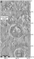
|
Posted by: Eyesonmars Dec 6 2012, 03:59 PM
Since another more or less identical EDL sequence might fly in 2018-2020 would a visit to some of the closer artifacts be justified? I don't remember either MER visiting a backshell or parachute for instance. We might learn something.
Posted by: RoverDriver Dec 6 2012, 04:42 PM
Maybe I was asleep at the wheel, but I thought Oppy did. http://marsrovers.jpl.nasa.gov/gallery/press/opportunity/20050203a/Sol330B_HeatShield_L257-B367R1.jpg Some of teh crud on her FHAZ was collected there? Uh, maybe we used the MI as well? http://marsrovers.jpl.nasa.gov/gallery/all/opportunity_m358.html But I don't know, I could be mistaken.
Paolo
Posted by: Explorer1 Dec 6 2012, 05:04 PM
Eyesonmars said backshell and parachute; there has been no close visits by either of the MERs. A combination of being too out of the way and the danger of entanglement were the reasons, I recall... Probably the same for MSL.
Posted by: djellison Dec 6 2012, 05:37 PM
The heatshield? No. Phenolic Impregnated CARBON Ablator. Moreover, it was very well instrumented using the MEDLI suite so it's performance can be measured and understood already.
Backshell? It did it's job - that's enough. parachute? We saw how well it did thanks to HiRISE, and, moreover, the deceleration performance that will have been recorded via IMU's
Skycrane? Well - there's not much point as it's just a football field sized debris zone - and lots of Hyrdazine lying around.
Posted by: Astro0 Apr 4 2013, 09:29 AM
What's been happening with Curiosity's parachute?
The answer my friends, is blowing in the wind 
http://www.jpl.nasa.gov/news/news.php?release=2013-121.
Posted by: fredk Apr 4 2013, 02:24 PM
They missed the earliest hirise image, which showed the 'chute in a different position - see http://www.unmannedspaceflight.com/index.php?s=&showtopic=7401&view=findpost&p=190688
Posted by: djellison Apr 4 2013, 03:51 PM
If only someone had already animated it
http://twitpic.com/c5eytt
Spirit's parachute has also moved in the past. Sadly, not enough observations at Meridiani to see if that's moved as well 
Posted by: PaulH51 Jan 10 2014, 11:45 AM
The answer my friends, is blowing in the wind
http://www.jpl.nasa.gov/news/news.php?release=2013-121.
Rough and Ready snip out of ESP_034572_1755_RED.QLOOK.JP2
Looks like the dark material ejected on impact has been dusted over in this rough extraction from the JP2 file, but I think it needs someone with more skills to sharpen the image and then expand the animation, so we can fully appreciate the changes over time
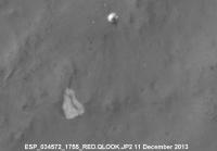
|
Paul
Posted by: climber Apr 1 2015, 08:21 PM
Found this on "SpaceRef". this shows how landing marks have changed over time.
http://www.jpl.nasa.gov/spaceimages/details.php?id=PIA19159
Powered by Invision Power Board (http://www.invisionboard.com)
© Invision Power Services (http://www.invisionpower.com)