Eagle and Endurance DEM's available! |

  |
Eagle and Endurance DEM's available! |
 May 17 2006, 09:30 AM May 17 2006, 09:30 AM
Post
#1
|
|||
|
Founder  Group: Chairman Posts: 14434 Joined: 8-February 04 Member No.: 1 |
http://anserver1.eprsl.wustl.edu/anteam/mera/mer_osu.htm
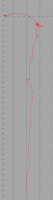
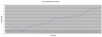
Two things.. 1. Phil - YAY - bundle adjusted references for all the sites in the top two txt files!!! And 2. Um....what does one do with those Bin's. Damn I wish I could code...if anyone knows a means to get that lot into any sort of appropriate 3D format they win the UMSF 'special cookie' award  Just for fun - I bunged the XY data of MERB into Excel. It's not 'square' i.e. it's not accurate - but I think I'll go for something accurate in Photoshop Also - Z axis against Sol for Spirit...I've seen that graph somewhere else...but making it ones self from data is always much more fun - you can clearly see Bonneville, Missoula, West Spur and the return to Larrys Lookout. Doug
Attached thumbnail(s)
|
||
 |
 
|
||
|
May 17 2006, 04:35 PM
Post
#2
|
|
 Dublin Correspondent Group: Admin Posts: 1799 Joined: 28-March 05 From: Celbridge, Ireland Member No.: 220 |
QUOTE (djellison @ May 17 2006, 10:30 AM)  And 2. Um....what does one do with those Bin's. Damn I wish I could code...if anyone knows a means to get that lot into any sort of appropriate 3D format they win the UMSF 'special cookie' award Well the .bin's are dead handy for converting directly to a graphical bump map, creating shaded relief maps and so on, I'm certainly going to have a bash at the latter later. Converting to a mesh requires some processing though and that's outside of my area of expertise at the moment. |
|
|
|
|
May 17 2006, 05:16 PM
Post
#3
|
|
|
Founder Group: Chairman Posts: 14434 Joined: 8-February 04 Member No.: 1 |
I've begun to make some progress - it's getting quite interesting
Some piccies of Endurance later perhaps  Doug |
|
|
|
|
May 17 2006, 07:52 PM
Post
#4
|
||
|
Dublin Correspondent Group: Admin Posts: 1799 Joined: 28-March 05 From: Celbridge, Ireland Member No.: 220 |
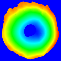
QUOTE (djellison @ May 17 2006, 06:16 PM) I've begun to make some progress - it's getting quite interesting Some piccies of Endurance later perhaps There's some oddness in the labelling of the files - the Eagle bin file is labelled as 68Mb but is 29,160,000 bytes (2700x2700x4bytes per data point), the endurance bin is labelled as 28Mb but is actually 1312416 bytes (588x558x4). Quick and dirty first pass at the Eagle bin file - converting to png. Apologies for the garish colour scheme but its a quick and dirty linear colour ramp just to see if the data all works.
I'm having some problems with the endurance bin - I'm not getting anything sensible out of it yet. |
|
|
|
|
|
|
May 17 2006, 08:03 PM
Post
#5
|
|
|
Dublin Correspondent Group: Admin Posts: 1799 Joined: 28-March 05 From: Celbridge, Ireland Member No.: 220 |
QUOTE (helvick @ May 17 2006, 08:52 PM) I'm having some problems with the endurance bin - I'm not getting anything sensible out of it yet. Just noticed that the eagle bin is big-endian (Motorola FP32) and the endurance one is little-endian (Intel FP32). Odd thing is that the eagle one works on my Intel machine and not the endurance one. Hmmh. |
|
|
|
|
May 17 2006, 09:00 PM
Post
#6
|
|||
|
Dublin Correspondent Group: Admin Posts: 1799 Joined: 28-March 05 From: Celbridge, Ireland Member No.: 220 |
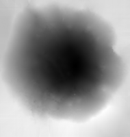
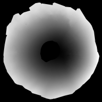
Something definitely odd - the file labelled Motorola FP32 (Eagle) is actually littlendian and the Intel FP32 (Enfurance) is bigendian. Maybe it was just a test. Anyway as "grayscale" images - got to work out how to output the data with better depth resolution (these are true color pngs just using gray values so there's really only 8 bits of depth) which is about 1cm for Eagle and 10cm for Endurance. The data for Endurance isn't quite square but the error is only about 0.07% so it amounts to less than half a pixel over the full image so it's not noticable.
Endurance:
Eagle:
|
||
|
|
|
||
|
May 17 2006, 10:46 PM
Post
#7
|
||
|
Founder Group: Chairman Posts: 14434 Joined: 8-February 04 Member No.: 1 |
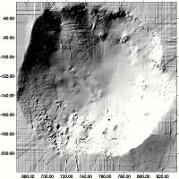
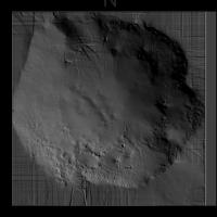
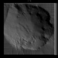
Obviously there are artifacts in the Endurance DEM - so I've used a mesh density half that of the actual DEM to help cull some of that - after all there is a disclaimer on the page saying that once they get a chance to sit down and catch their breath they'll get these tidied up etc. Who knows...we might end up with one of the Southern Basin, or Victoria Crater
I think probably the most appropriate 'res' for something like this lies between the two densities...something like 1 million points is essentially 'plenty' Doug
Attached thumbnail(s)
|
|
|
|
|
|
|
May 17 2006, 11:01 PM
Post
#8
|
|
|
Dublin Correspondent Group: Admin Posts: 1799 Joined: 28-March 05 From: Celbridge, Ireland Member No.: 220 |
QUOTE (djellison @ May 17 2006, 11:46 PM) I think probably the most appropriate 'res' for something like this lies between the two densities...something like 1 million points is essentially 'plenty' I've run into a wall with trying to push the data out in a decent 16bit grayscale format using the quick and dirty approach. I'll try again tomorrow with something a bit more capable than Perl::GD. I'm still a bit confused about the big endian \ little endian thing though doesn't make much sense. |
|
|
|
|
May 18 2006, 04:19 AM
Post
#9
|
|||
 Senior Member Group: Members Posts: 2228 Joined: 1-December 04 From: Marble Falls, Texas, USA Member No.: 116 |
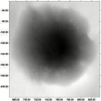
Nice work with that last one, Doug. I need to refresh my skills with this grid plotting software, as I didn't create anything as pretty as your view. I'm working with the ASCII files, since they are easily accepted by my software. I can see that there is quite a bit of detail in the data; now to learn to bring it out as you have. I tried a shaded relief map of Endurance, but it was difficult to make it look well, and it appears to have a strange network of artifacts. I wonder if that is some of what they hope to eventually clean up.
I found it curious that the ASCII file for Eagle was huge...60+ MB, while that for Endurance was relatively small.
Attached thumbnail(s)
-------------------- ...Tom
I'm not a Space Fan, I'm a Space Exploration Enthusiast. |
||
|
|
|
||
|
May 18 2006, 07:00 AM
Post
#10
|
|||
|
Founder Group: Chairman Posts: 14434 Joined: 8-February 04 Member No.: 1 |
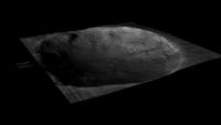
I used the Ascii files with Surfer, but then 3dem with the bin files to generate a Terragen mesh from which I made a Tif which I used as a displacement map
There's what, 250k points on the End one, 7.29 million in the Eag one - so it's 30 times more data than the End one...not suprising it's a bit big. I wondering if perhaps, just perhaps this little easter egg of data is in response to the email I sent to Prof Li a few months ago asking if he could do elev maps for us nutters Attached - the dem at the best res I've got it into 3ds, and the res I actually use it at Doug
Attached thumbnail(s)
|
||
|
|
|
||
|
May 18 2006, 10:21 AM
Post
#11
|
|
|
Founder Group: Chairman Posts: 14434 Joined: 8-February 04 Member No.: 1 |
6.6 Megish...
http://www.unmannedspaceflight.com/doug_im...nd_dem_phil.wmv Not happy with the compression though - I'll try a H264 Mov at 720p and half 720p later Doug |
|
|
|
|
May 18 2006, 01:11 PM
Post
#12
|
|
 Member Group: Members Posts: 198 Joined: 2-March 05 From: Richmond, VA USA Member No.: 181 |
Beautifull work -- particularly nice with the overlay.
-- Pertinax |
|
|
|
|
May 18 2006, 01:22 PM
Post
#13
|
|
|
Solar System Cartographer Group: Members Posts: 10229 Joined: 5-April 05 From: Canada Member No.: 227 |
Very nice maps. The artifacts in the Endurance map must be caused by the interpolation routine they use to grid the data.
Phil -------------------- ... because the Solar System ain't gonna map itself.
Also to be found posting similar content on https://mastodon.social/@PhilStooke Maps for download (free PDF: https://upload.wikimedia.org/wikipedia/comm...Cartography.pdf NOTE: everything created by me which I post on UMSF is considered to be in the public domain (NOT CC, public domain) |
|
|
|
|
May 18 2006, 04:03 PM
Post
#14
|
|
|
Member Group: Members Posts: 320 Joined: 19-June 04 Member No.: 85 |
Great piece of work, Doug. In the video, it really becomes clear that the rocks from Escher to Wopmay are part of a slump feature. And it's possible to follow the contact between the Upper and Middle Units of the Burns Formation. Really cool!
-------------------- |
|
|
|
|
Jun 24 2006, 01:14 AM
Post
#15
|
|
 Member Group: Members Posts: 656 Joined: 20-April 05 From: League City, Texas Member No.: 285 |
QUOTE (djellison @ May 18 2006, 05:21 AM) 6.6 Megish... http://www.unmannedspaceflight.com/doug_im...nd_dem_phil.wmv Not happy with the compression though - I'll try a H264 Mov at 720p and half 720p later Doug Very nice. Funny, the bowl of the crater has much shallower slopes than I'd anticipated... my perception had been that the rim was pretty steep. Good job of eliminating the artifacts. |
|
|
|
|

|
Lo-Fi Version | Time is now: 26th September 2024 - 05:04 PM |
|
RULES AND GUIDELINES Please read the Forum Rules and Guidelines before posting. IMAGE COPYRIGHT |
OPINIONS AND MODERATION Opinions expressed on UnmannedSpaceflight.com are those of the individual posters and do not necessarily reflect the opinions of UnmannedSpaceflight.com or The Planetary Society. The all-volunteer UnmannedSpaceflight.com moderation team is wholly independent of The Planetary Society. The Planetary Society has no influence over decisions made by the UnmannedSpaceflight.com moderators. |
SUPPORT THE FORUM Unmannedspaceflight.com is funded by the Planetary Society. Please consider supporting our work and many other projects by donating to the Society or becoming a member. |
|