Dawn data in the PDS |

  |
Dawn data in the PDS |
 Aug 11 2013, 08:19 AM Aug 11 2013, 08:19 AM
Post
#76
|
|
|
Member  Group: Members Posts: 890 Joined: 18-November 08 Member No.: 4489 |
LSB vs. MSB
aren't 16 bit images fun |
 |
 
|
|
Aug 12 2013, 10:27 AM
Post
#77
|
|
|
Junior Member Group: Members Posts: 22 Joined: 23-August 11 From: France Member No.: 6134 |
QUOTE (Bjorn Jonsson @ Aug 11 2013, 01:03 AM)  Everything works now. This is a test image where a HAMO image has been draped over the shape model: [attachment=30706:vesta_dem_img.jpg] Even though everything works I'm still interested in how accurate the relased camera pointing information should be. Some discrepancies remain but they are much smaller than earlier. For the RC3 images I've tested it's almost perfect though, the error is typically 2-4 pixels. In contrast, there are some differences between HAMO images and rendered shape model images, typically 20-30 pixels. That's probably normal. In the image above I made a relatively crude correction to the pointing - I'll do it more accurately once I start mosaicking images. I'm also interested in the accuracy of the spacecraft position; I'm assuming it to be very accurate. Firstly I'm glad that your projections work now and I'm waiting for new pictures of Vesta  I suppose that the Dawn Team quickly realized that the pole orientation measure with Hubble data is wrong. And i suppose that the decision of choosing Claudia as Prime merdien came latter when the Gaskell shape was already done. I think that i forgot something important: the rotation rate has been reevaluated too. I just get it when i read your comments. So in order to work with Gaskell shape i think that the parameters in pck file should be: BODY2000004_POLE_RA = ( 309.031 0.0 0.0 ) BODY2000004_POLE_DEC = ( 42.235 0.0 0.0 ) BODY2000004_PM = ( 292.0 1617.3329428 0.0 ) The difference concerned only rotation rate and is very small but maybe important i didn't test it. Concerning the accuracy of position and pointing, I'm not sure but i suppose that the pointing should be very precise since Dawn is able to orientate herself and every telemetry data are stored on board before sent to Earth. The position seems to me more problematic because the DNS sessions are limited. Someone has more info about it ? |
|
|
|
|
Aug 12 2013, 09:20 PM
Post
#78
|
|
|
Junior Member Group: Members Posts: 22 Joined: 23-August 11 From: France Member No.: 6134 |
I tested with the new rate rotation and it doesn't work: i have a difference of more than 5 pixels in a survey pictures.
I will try to investigate latter why. But i think that it is related to the Prime Meridian parameters should be adjusted if the rate rotation is adjusted. Very sorry for any confusion. |
|
|
|
|
Aug 13 2013, 09:34 PM
Post
#79
|
|
 Member Group: Members Posts: 568 Joined: 20-April 05 From: Silesia Member No.: 299 |
-------------------- Free software for planetary science (including Cassini Image Viewer).
http://members.tripod.com/petermasek/marinerall.html |
|
|
|
|
Aug 23 2013, 11:33 PM
Post
#80
|
||||
 IMG to PNG GOD Group: Moderator Posts: 2250 Joined: 19-February 04 From: Near fire and ice Member No.: 38 |
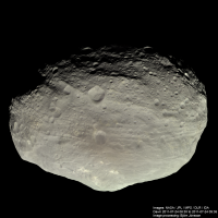
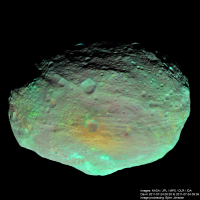
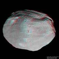
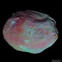
I now have some results of my processing. They recently appeared in the the Planetary Society blog but for completeness I'm posting the images here as well. And there's more to come in (probably) a few days.
First an approximately true color global image (R/G/B filters used) from the RC3 approach data obtained at a distance of about 5200 km:
And a false color image from the same observation. Here images taken at 918 nm, 749 nm and 438 bm are used as red, green and blue, respectively:
Each image is created from four sets of source images that have been draped over the shape model and the terminator then corrected as described in the blog entry I mentioned above. An here is an anaglyph made from the survey data using 18 blue filtered images. The processing is comparable to the processing used for the RC3 approach data above.
This is a wonderful dataset but it requires complicated processing if big, high quality mosaics are what you want. QUOTE (Sarunia @ Aug 12 2013, 09:20 PM) I tested with the new rate rotation and it doesn't work: i have a difference of more than 5 pixels in a survey pictures. I will try to investigate latter why. But i think that it is related to the Prime Meridian parameters should be adjusted if the rate rotation is adjusted. This is consistent with what I found. Previously the error (survey data) was ~8 pixels in the data I used, mainly in the horizontal direction. But when using the new rotation rate the error was bigger in the vertical direction (and also bigger in magnitude, about 10 pixels). And big thanks for your help (coordinate systems and converting the shape model) which greatly speeded up what I was doing - a great example of 'cooperative image processing'. I should mention that I'm still interested in the accuracy of the pointing data (SPICE CK kernels) if anyone knows anything about it, just to confirm that the source of the errors I'm getting is there (I think it is but I'm not 100% sure). |
|||
|
|
|
|||
|
Sep 18 2013, 11:19 PM
Post
#81
|
|||
|
IMG to PNG GOD Group: Moderator Posts: 2250 Joined: 19-February 04 From: Near fire and ice Member No.: 38 |
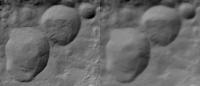
Here are two global mosaics from the survey phase of the mission:
Both of these images are mosaics of 17 individual color frames. The images were created by first creating a big simple cylindrical map and then draping it over the Gaskell shape model. The processing associated with this is similar to the processing of the images I posted earlier (see this Planetery Society blog entry for further details). This has been one of the most complex image processing projects I have ever finished. The left image is an approximately true color composite using data from the red, green and blue filters with the color corrected using Vesta's spectrum. This correction made the color a bit more saturated and reddish. Some color variations can be seen but they are rather subtle. The right image is from the same sequence but using data from the 918 nm, 749 nm and 438 nm (blue filter) as red, green and blue respectively. It has been processed to bring out color differences by first making Vesta's average global color approximately gray and then greatly increasing the color saturation. Note that this processing differs a bit from the processing of a similar image from the RC3 sequence. There I didn't make the average color gray before increasing the color saturation; this is the main reason for the different overall color here. This processing has brought out lots of interesting features. For example I find some of the long and narrow, red features interesting and now I also want to find higher resolution color data for some of the colorful craters in this composite (in other words: There's more to come). One caveat: There are probably some inaccuracies in the large scale color variations since it was difficult to get a competely seamless mosaic without manually messing a bit with the color where the images overlap to get rid of the seams. This was especially important here since the processing tends to bring out the seams and I don't want that. The source images were obtained on August 20, 2011 when Dawn was about 3000 km from Vesta's center. |
||
|
|
|
||
|
Sep 19 2013, 12:25 AM
Post
#82
|
|
|
Solar System Cartographer Group: Members Posts: 10146 Joined: 5-April 05 From: Canada Member No.: 227 |
Beautiful, Bjorn - well done!
Phil -------------------- ... because the Solar System ain't gonna map itself.
Also to be found posting similar content on https://mastodon.social/@PhilStooke NOTE: everything created by me which I post on UMSF is considered to be in the public domain (NOT CC, public domain) |
|
|
|
|
Sep 19 2013, 02:55 PM
Post
#83
|
|
 Interplanetary Dumpster Diver Group: Admin Posts: 4404 Joined: 17-February 04 From: Powell, TN Member No.: 33 |
Simply stunning! These are the first large, color mosaics without gaps with consistent illumination that I have seen of Vesta.
-------------------- |
|
|
|
|
Oct 20 2013, 09:18 PM
Post
#84
|
|
|
Junior Member Group: Members Posts: 48 Joined: 10-September 06 Member No.: 1129 |
Does anyone know when we can expect the first better-than-Hubble images of Ceres?
|
|
|
|
|
Oct 20 2013, 09:28 PM
Post
#85
|
|
 Administrator Group: Admin Posts: 5172 Joined: 4-August 05 From: Pasadena, CA, USA, Earth Member No.: 454 |
It will be not long after they get the first pictures, and that will be in February 2015.
-------------------- My website - My Patreon - @elakdawalla on Twitter - Please support unmannedspaceflight.com by donating here.
|
|
|
|
|
Jan 8 2014, 02:55 PM
Post
#86
|
|
|
Member Group: Members Posts: 102 Joined: 29-January 10 From: Poland Member No.: 5205 |
Here is Dawn approach to Vesta from 305 images at 2 FPS.
See at 720p to better view. http://www.youtube.com/watch?v=IAjsqqsuDqE -------------------- Adam Hurcewicz from Poland
|
|
|
|
|
Jun 22 2014, 01:34 AM
Post
#87
|
|||
|
IMG to PNG GOD Group: Moderator Posts: 2250 Joined: 19-February 04 From: Near fire and ice Member No.: 38 |
Strictly speaking not PDS but it's comparable: I recently found this goldmine of data from Dawn:
http://dawndata.igpp.ucla.edu/tw.jsp?section=data I'm not sure why I didn't find this earlier. A possible reason is that it's apparently relatively new (most of the files there have dates from November 2013). Among other things this site includes a very hi-res DEM/shapemodel of Vesta: http://dawndata.igpp.ucla.edu/tw.jsp?secti...Ms/DLR_HAMO_DTM This DEM has a much higher resolution than the DEM discussed earlier in this thread, i.e. here and in more detail here. The north polar region is also better in the new model. Here is a quick comparison render:
The new shape model is in the Claudia coordinate system and not in a 'hybrid' coordinate system like the older one. In fact everything at the site mentioned above is in the Claudia coordinate system. Interestingly I'm getting significantly better pointing and/or position accuracy using the new shape model. There are also several maps there, including a true color map processed to appear as if the sun was illuminating all of the surface from directly above. Here is a quick and dirty test render that combines the true color map with the shape model. It has a 40 degree field of view:
The true color map has some artifacts and blank spots that are visible here. There is also a vertical 'seam' at x=0 in the shape model, a surprisingly common problem in various DEMs and maps. But this is easy to fix in Photoshop. |
||
|
|
|
||
|
Jul 22 2014, 04:30 PM
Post
#88
|
|||||
|
IMG to PNG GOD Group: Moderator Posts: 2250 Joined: 19-February 04 From: Near fire and ice Member No.: 38 |
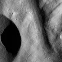
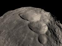
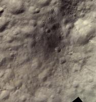
Here are two images showing Aricia Tholus:
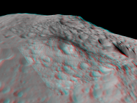
North is up. The first one is an approximately true color mosaic from HAMO data. The second one shows more details and includes LAMO images colorized from the HAMO images. The HAMO images were obtained by Dawn on October 26, 2011 and the LAMO images on April 30, 2012. Dawn imaged Vesta globally using all of its color filters during the HAMO mission phase. A lot of clear filter coverage was also acquired during LAMO but color coverage is limited. Only the 918, 749 and 548 nm filters were used for color during LAMO, the images are 2x2 binned and only cover selected parts of Vesta's surface. So if you want RGB LAMO images you must use HAMO images to colorize the LAMO clear filter images. As in the images I have posted earlier in this thread, the above mosaics were made by using the shape model to reproject the images to simple cylindrical projection. All of the mosaicking and color work was then done in simple cylindrical projection and the final image products then made by rendering the shape model with the map draped over it. The shape model is big and accurate enough that this works very well for HAMO and LAMO data. I sometimes needed to translate the reprojected data by 1-2 pixels in the x and/or y direction though when doing color composites and/or mosaics. Aricia Tholus is really a mountain but this is not obvious in the images above where we are looking directly down. But an anaglyph made by draping the above HAMO image on the hi-res shape model shows this beautifully; here we are looking to the west:
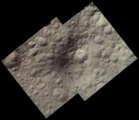
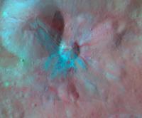
This also makes it obvious that even though some of Aricia Tholus is dark, parts of it are made darker by being tilted away from the sun. I should mention that I converted the shape model to a png file using the following img2png command: img2png global.pds -fstretch211946,293010 This results in a png file where black represents points that are 211.946 km from Vesta's center and white is 263.010 km from Vesta's center. This is the full elevation range of the shape model. The most recent version of img2png must be used for this to work properly. Of course it is also possible to use false color HAMO data to colorize the higher resolution LAMO data. Here is an example showing Aelia, a small crater with interesting streamer-like crater rays:
Here 918, 749 and 548 nm HAMO images are used for red, green and blue respectively. Color saturation has been greatly exaggerated, I set the saturation to 85 in Photoshop after first making the average color of the image gray. The HAMO images were obtained by Dawn on October 4, 2011 and the two LAMO images on January 10, 2012 and April 30, 2012. |
||||
|
|
|
||||
|
Jul 22 2014, 06:56 PM
Post
#89
|
|
 Member Group: Members Posts: 796 Joined: 27-February 08 From: Heart of Europe Member No.: 4057 |
Beautiful images!
BTW, I missed completely your last post so thank you for that link with DEM, I didn't know it. I hope they will release DEM with topography relative to some gravitational equipotential surface. -------------------- |
|
|
|
|
Jul 22 2014, 07:51 PM
Post
#90
|
|
|
Solar System Cartographer Group: Members Posts: 10146 Joined: 5-April 05 From: Canada Member No.: 227 |
I missed that initial post too. Very interesting. I would really like to see a set of smaller browse images to let you get a quick feel for the data before downloading a bunch of > Gb files. But there's lots here to work with.
Phil -------------------- ... because the Solar System ain't gonna map itself.
Also to be found posting similar content on https://mastodon.social/@PhilStooke NOTE: everything created by me which I post on UMSF is considered to be in the public domain (NOT CC, public domain) |
|
|
|
|

|
Lo-Fi Version | Time is now: 18th April 2024 - 07:12 PM |
|
RULES AND GUIDELINES Please read the Forum Rules and Guidelines before posting. IMAGE COPYRIGHT |
OPINIONS AND MODERATION Opinions expressed on UnmannedSpaceflight.com are those of the individual posters and do not necessarily reflect the opinions of UnmannedSpaceflight.com or The Planetary Society. The all-volunteer UnmannedSpaceflight.com moderation team is wholly independent of The Planetary Society. The Planetary Society has no influence over decisions made by the UnmannedSpaceflight.com moderators. |
SUPPORT THE FORUM Unmannedspaceflight.com is funded by the Planetary Society. Please consider supporting our work and many other projects by donating to the Society or becoming a member. |
|