Chang'e 5 sample return mission |

  |
Chang'e 5 sample return mission |
 Jan 14 2015, 01:42 PM Jan 14 2015, 01:42 PM
Post
#76
|
|
|
Solar System Cartographer  Group: Members Posts: 10229 Joined: 5-April 05 From: Canada Member No.: 227 |
Anatoly Zak has an article here with images of Earth and the Moon taken from L2:
http://sen.com/news/china-puts-spacecraft-into-moon-orbit Phil -------------------- ... because the Solar System ain't gonna map itself.
Also to be found posting similar content on https://mastodon.social/@PhilStooke Maps for download (free PDF: https://upload.wikimedia.org/wikipedia/comm...Cartography.pdf NOTE: everything created by me which I post on UMSF is considered to be in the public domain (NOT CC, public domain) |
 |
 
|
|
Jan 22 2015, 04:34 AM
Post
#77
|
|
|
Senior Member Group: Members Posts: 2106 Joined: 13-February 10 From: Ontario Member No.: 5221 |
A lower orbit now: http://spaceflightnow.com/2015/01/21/chine...in-lunar-orbit/
Images of the potential sample return landing sight coming in April, apparently (but nothing yet on where). |
|
|
|
|
Jan 22 2015, 01:39 PM
Post
#78
|
|
|
Solar System Cartographer Group: Members Posts: 10229 Joined: 5-April 05 From: Canada Member No.: 227 |
Suggestions have been circulated that the region will be Oceanus Procellarum. I have suggested that the most likely area would be the area of the youngest known mare basalts (determined from crater counting), south of Aristarchus. This is (one of the top scientific targets on many lists as it shows how long mare volcanism continued. A secondary goal would be Aristarchus ejecta, and a tertiary goal would be ejecta thrown off the nearby Aristarchus Plateau.
Phil -------------------- ... because the Solar System ain't gonna map itself.
Also to be found posting similar content on https://mastodon.social/@PhilStooke Maps for download (free PDF: https://upload.wikimedia.org/wikipedia/comm...Cartography.pdf NOTE: everything created by me which I post on UMSF is considered to be in the public domain (NOT CC, public domain) |
|
|
|
|
Feb 8 2015, 10:32 PM
Post
#79
|
||
 Member Group: Members Posts: 559 Joined: 1-May 06 From: Scotland (Ecosse, Escocia) Member No.: 759 |
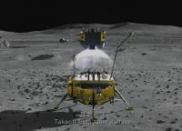
Leonard David has posted this visualisation of the Chinese sample return mission taking off from the moon.
It fits very well with the design drawing shown in Post #9 in this thread. It also lays to rest the older design portrayed in Post #8. Leonard David - China Lunar Orbiter
|
|
|
|
|
|
|
Jul 17 2015, 01:03 AM
Post
#80
|
|
|
Solar System Cartographer Group: Members Posts: 10229 Joined: 5-April 05 From: Canada Member No.: 227 |
http://www.cast.cn/CastCn/Show.asp?ArticleID=48907
News that the Chang'E 5 T-1 test vehicle, still orbiting the moon, began imaging potential landing sits in May. No images released yet. Phil Google translation: ---------------------------- May 28 15:10 pm camera power is first applied a test shot, successfully shot two minutes of the Earth video, get a clear image of the earth. After the implementation of the third lunar imaging, to obtain images of more than 3,000 frames, good image quality. The imaging camera to obtain a 2.5m resolution images of the lunar surface, indicating that the camera is operating normally in orbit long for the subsequent expansion of tasks carried out to provide a strong guarantee. [China Academy of Space Technology copyright owners, please indicate the source] -------------------- ... because the Solar System ain't gonna map itself.
Also to be found posting similar content on https://mastodon.social/@PhilStooke Maps for download (free PDF: https://upload.wikimedia.org/wikipedia/comm...Cartography.pdf NOTE: everything created by me which I post on UMSF is considered to be in the public domain (NOT CC, public domain) |
|
|
|
|
Jul 17 2015, 01:50 AM
Post
#81
|
|
|
Senior Member Group: Members Posts: 2106 Joined: 13-February 10 From: Ontario Member No.: 5221 |
Was the full mosaic in this article released already? I seem to recall only seeing the single frame with Earth and the lunar far side visible.
http://gbtimes.com/china/china-unveils-pla...ture-lunar-base |
|
|
|
|
Jul 17 2015, 06:50 AM
Post
#82
|
|
|
Solar System Cartographer Group: Members Posts: 10229 Joined: 5-April 05 From: Canada Member No.: 227 |
Yes, that has been out for a while.
Phil -------------------- ... because the Solar System ain't gonna map itself.
Also to be found posting similar content on https://mastodon.social/@PhilStooke Maps for download (free PDF: https://upload.wikimedia.org/wikipedia/comm...Cartography.pdf NOTE: everything created by me which I post on UMSF is considered to be in the public domain (NOT CC, public domain) |
|
|
|
|
Sep 2 2015, 09:46 PM
Post
#83
|
|
|
Newbie Group: Members Posts: 16 Joined: 25-January 14 Member No.: 7109 |
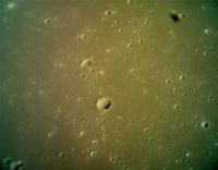
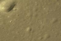
CE5T1 completes imaging CE5's landing zone: http://news.sina.com.cn/c/2015-09-02/203732269747.shtml (Chinese)
The resolution is said to be 1m/pix. CE5T1 also verify the techniques needed to control the ascending module and service module. |
|
|
|
|
Sep 2 2015, 09:55 PM
Post
#84
|
|||
|
Newbie Group: Members Posts: 5 Joined: 4-October 14 Member No.: 7274 |
QUOTE (Yeh @ Sep 3 2015, 12:46 AM)  CE5T1 completes imaging CE5's landing zone: http://news.sina.com.cn/c/2015-09-02/203732269747.shtml (Chinese) The resolution is said to be 1m/pix. CE5T1 also verify the techniques needed to control the ascending module and service module. Pics attached
Attached thumbnail(s)
|
||
|
|
|
||
|
Sep 2 2015, 11:06 PM
Post
#85
|
|
|
Solar System Cartographer Group: Members Posts: 10229 Joined: 5-April 05 From: Canada Member No.: 227 |
One way to interpret the Chinese text is that this imaging from 30 Aug. to 2 Sept completed the imaging of the fifth potential landing site. I don't know where any of them are yet - if anyone knows please let me know. But nice to know there are five candidates.
EDIT - the more I think about it, the more I suspect that the 'fifth' referred to is the fifth spacecraft, Chang'E 5. Google Translate is a blunt instrument for probing difficult questions. There might only be one site after all. I hope we will learn more soon. EDIT AGAIN - a bit of detective work. The terminator was crossing the Mare Crisium area over the few days the images were taken. I had been expecting a landing in Oceanus Procellarum, but the sun would have been overhead there, and these images have shadows suggesting a lower sun elevation. Possibly a site in the eastern maria, but west of Crisium. Not much to go on yet. Phil -------------------- ... because the Solar System ain't gonna map itself.
Also to be found posting similar content on https://mastodon.social/@PhilStooke Maps for download (free PDF: https://upload.wikimedia.org/wikipedia/comm...Cartography.pdf NOTE: everything created by me which I post on UMSF is considered to be in the public domain (NOT CC, public domain) |
|
|
|
|
Sep 3 2015, 07:01 AM
Post
#86
|
|
 Senior Member Group: Members Posts: 1729 Joined: 3-August 06 From: 43° 35' 53" N 1° 26' 35" E Member No.: 1004 |
QUOTE (Phil Stooke @ Sep 3 2015, 01:06 AM) One way to interpret the Chinese text is that this imaging from 30 Aug. to 2 Sept completed the imaging of the fifth potential landing site. there is also a release in English here: China's lunar orbiter gets close-up pictures of the Moon it is clearly stated that the orbiter imaged the landing site of CE-5 |
|
|
|
|
Sep 3 2015, 03:13 PM
Post
#87
|
|
 Administrator Group: Admin Posts: 5172 Joined: 4-August 05 From: Pasadena, CA, USA, Earth Member No.: 454 |
Is there anything that indicates whether Chang'e 5 T1 is being used to image the potential farside landing site of Chang'e 4?
-------------------- My website - My Patreon - @elakdawalla on Twitter - Please support unmannedspaceflight.com by donating here.
|
|
|
|
|
Sep 3 2015, 04:29 PM
Post
#88
|
|
|
Administrator Group: Admin Posts: 5172 Joined: 4-August 05 From: Pasadena, CA, USA, Earth Member No.: 454 |
Came across this July 29 item on the CAST website having something to do with a "3D mode" for a Chang'e 5 camera, but I can't make heads or tails of the Google translation.
-------------------- My website - My Patreon - @elakdawalla on Twitter - Please support unmannedspaceflight.com by donating here.
|
|
|
|
|
Sep 3 2015, 05:14 PM
Post
#89
|
|
|
Newbie Group: Members Posts: 16 Joined: 25-January 14 Member No.: 7109 |
QUOTE (Phil Stooke @ Sep 2 2015, 06:06 PM) One way to interpret the Chinese text is that this imaging from 30 Aug. to 2 Sept completed the imaging of the fifth potential landing site. I don't know where any of them are yet - if anyone knows please let me know. But nice to know there are five candidates. EDIT - the more I think about it, the more I suspect that the 'fifth' referred to is the fifth spacecraft, Chang'E 5. Google Translate is a blunt instrument for probing difficult questions. There might only be one site after all. I hope we will learn more soon. EDIT AGAIN - a bit of detective work. The terminator was crossing the Mare Crisium area over the few days the images were taken. I had been expecting a landing in Oceanus Procellarum, but the sun would have been overhead there, and these images have shadows suggesting a lower sun elevation. Possibly a site in the eastern maria, but west of Crisium. Not much to go on yet. Phil Phil -- I believe the "fifth" indeed refers to the fifth probe in the Chang'E series. And it is from a verified source that CE5 will land in Oceanus Procellarum: http://news.xinhuanet.com/tech/2014-09/04/c_1112367913.htm (Chinese). QUOTE (elakdawalla @ Sep 3 2015, 11:29 AM) Came across this July 29 item on the CAST website having something to do with a "3D mode" for a Chang'e 5 camera, but I can't make heads or tails of the Google translation. It is about a documentary film or something -- they take the film in 3D. Nothing to do with CE5 or CE5T1 the probes. |
|
|
|
|
Oct 12 2015, 05:17 PM
Post
#90
|
|
|
Solar System Cartographer Group: Members Posts: 10229 Joined: 5-April 05 From: Canada Member No.: 227 |
https://agu.confex.com/agu/fm15/meetingapp.cgi/Paper/68812
AGU abstract - it says the landing site is in the northeastern part of Oceanus Procellarum. Phil -------------------- ... because the Solar System ain't gonna map itself.
Also to be found posting similar content on https://mastodon.social/@PhilStooke Maps for download (free PDF: https://upload.wikimedia.org/wikipedia/comm...Cartography.pdf NOTE: everything created by me which I post on UMSF is considered to be in the public domain (NOT CC, public domain) |
|
|
|
|

|
Lo-Fi Version | Time is now: 27th September 2024 - 10:08 AM |
|
RULES AND GUIDELINES Please read the Forum Rules and Guidelines before posting. IMAGE COPYRIGHT |
OPINIONS AND MODERATION Opinions expressed on UnmannedSpaceflight.com are those of the individual posters and do not necessarily reflect the opinions of UnmannedSpaceflight.com or The Planetary Society. The all-volunteer UnmannedSpaceflight.com moderation team is wholly independent of The Planetary Society. The Planetary Society has no influence over decisions made by the UnmannedSpaceflight.com moderators. |
SUPPORT THE FORUM Unmannedspaceflight.com is funded by the Planetary Society. Please consider supporting our work and many other projects by donating to the Society or becoming a member. |
|