Opportunity Route Map |

  |
Opportunity Route Map |
 Nov 10 2005, 04:10 AM Nov 10 2005, 04:10 AM
Post
#871
|
||
 Senior Member  Group: Members Posts: 2492 Joined: 15-January 05 From: center Italy Member No.: 150 |
Thanks to you Tman!
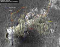
Here below I extended to previous way-point (Sol626) based also on direction of distant features, in particular the small crater on the left (visible in the inset)... this was another suggestion from Forum members in this thread.  Edit: further improvement / added Sol630 projection This post has been edited by dilo: Nov 10 2005, 04:54 AM
Attached thumbnail(s)
-------------------- I always think before posting! - Marco -
|
|
 |
 
|
|
| Guest_Myran_* |
Nov 10 2005, 05:05 AM
Post
#872
|
|
Guests |
Thank you Dilo and welcome back.
Your map tells me that we're close, lets hope we dont get any limited sols so that we can have a look at that crop of rock now around the weekend please! Ive been waiting for that a long time. 
|
|
|
|
|
Nov 10 2005, 11:25 AM
Post
#873
|
|
|
Senior Member Group: Moderator Posts: 4279 Joined: 19-April 05 From: .br at .es Member No.: 253 |
QUOTE (dilo @ Nov 10 2005, 06:10 AM) Thanks to you Tman! Here below I extended to previous way-point (Sol626) based also on direction of distant features, in particular the small crater on the left (visible in the inset)... this was another suggestion from Forum members in this thread. Edit: further improvement / added Sol630 projection  Hats off for this work, Dilo! My first impression, few weeks ago, was that it would be too difficult, if ever possible, to match ripples, ripples and more ripples together. Well, here is the answer. BTW, are you planning to reconstruct the whole route back to sol 621? Just a small correction. The pics from sol 630 actually represent the driving made on sol 627. Oppy drove on 627, and the nav/pancams were planned for 628 but not executed. They were re-planned for sol 630 and finally shooted. Wrt the placement for 627/630 I would expect it to be a bit northwards. Per your map, a->b is 66m while b->c is just 6m. MER mission updates report 51m on sol 627 (a->b) and 39m on sol 631 (b->c). I know we should take those numbers with a grain of salt, but imho the discrepancy is too big. |
|
|
|
|
Nov 10 2005, 09:34 PM
Post
#874
|
|
|
Senior Member Group: Members Posts: 2492 Joined: 15-January 05 From: center Italy Member No.: 150 |
Thanks for the correction on Sol numbers, Tesheiner!
About travelled distance, I'm pretty confident on Sol626 position, because I established it by triangulating 3 far elements. About Sol630 (627) position, there is some degree of uncertain... but, are we sure that this last panorama was taken at the end of the daily traverse? I agree about the total distances traveled that do not match (90m vs 72m)... but attention, I didn't consider maneuvers nor slippage, while I suspect NASA reports refers to odometry data. In fact, I consider simply distance between initial and final waypoints, without considering the path; this can produce a sensible underestimation of the traveled distance! Finally, about plan to reconstruct the whole route back to sol 621 (and eventually correct also orientation errors before it), I already produced all vertical projections to assemble. All depends on my ability to find distant referring points to precisely establish rover positions, so is a delicate and long work and cannot guarantee success. Anyway, I definitely will try! -------------------- I always think before posting! - Marco -
|
|
|
|
|
Nov 11 2005, 10:12 AM
Post
#875
|
|
|
Senior Member Group: Moderator Posts: 4279 Joined: 19-April 05 From: .br at .es Member No.: 253 |
Hi Dilo,
Wrt sol 626, my last attempt was made using 9 control points, but I don't remember if it was posted here or not. I should check it (Edited: it's here). With that estimation I've got around 93m from 626 to 631 positions. Anyway, this is really not a big issue. Wrt sol 627, there is only one 360º navcam pano taken on sol 630, plus two sets of "drive-direction" pancam mosaics. I also took 3 control points to estimate the position AND double-checked it with some parallax calculation to the first outcrop, now named "Olympia". I did again some parallax calculations to the piece of outcrop which can be seen on the middle of this pancam image (http://marsrovers.jpl.nasa.gov/gallery/all..._P2412L2M1.HTML) taken on sol 630 (i.e. after 627 drive) and the result is: --- Camera: PANCAM nl: 510 nr: 601 dim: 1 object distance: 27.4 m, one-pixel error: 0.352 m object dimension: 0.8 cm --- That outcrop is a bit north of Olympia and can be recognized (I think) on your last map, just below the "b". Btw, the access to the pics with drive id "##" seems to be solved at the MER webpage. I'm looking forward your whole route back. Let me tell you I've generally used the following reference points: - North/south features seen on an unnamed crater to the east. - Dark outcrop at Mogollon rim - Outcrop east of Olympia. Now I'm trying to refine those estimations by including Viking & Voyager craters, but they are barely visible on navcams and sometimes may be confused with jpeg artifacts. This post has been edited by Tesheiner: Nov 11 2005, 10:17 AM |
|
|
|
|
Nov 11 2005, 11:13 AM
Post
#876
|
|
|
Senior Member Group: Members Posts: 2998 Joined: 30-October 04 Member No.: 105 |
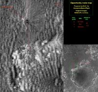
I have a little confusion about the exact route north and around that dunefield getting from the Four Lane to Olympia. Based on my observations at the time, with reference to Tesheiner's bearings-to-features, I think that it is the lower track on the attached map. But Dilo seems to indicate a differnt route, shown as the upper track on my map.
The reference points used by Tesheiner are the best there are in this area. FWIW... --Bill -------------------- |
|
|
|
|
Nov 11 2005, 01:31 PM
Post
#877
|
||
|
Senior Member Group: Moderator Posts: 4279 Joined: 19-April 05 From: .br at .es Member No.: 253 |
Let me add something to the confusion, sorry.
I overlayed Bill's picture on my map; the result is a bit fuzzy but its enough to show the difference about all the proposed/calculated paths. I hope we will be able to solve this puzzle.
Attached thumbnail(s)
|
|
|
|
|
|
|
Nov 11 2005, 01:50 PM
Post
#878
|
|
|
Senior Member Group: Members Posts: 2998 Joined: 30-October 04 Member No.: 105 |
Ah, I see that I missed the Sol 626 waypoint, and that is the major difference between your and my paths. We are playing "blind man's bluff" here since there are no landmarks to verify location. Let's face it, one ripple or trough looks much like the other. At best, we are guesstimating (guess + estimate) positions when going through that ripple field. Except for being right for the sake of correctness, it doesn't matter in that area we just passed through-- the paths show the general route Oppy took. Now that Oppy is at Olympia and moving towards Mogollon itis possible-- and there is the need-- for accurate positions that can be based on visible outcrops and distinctive ripples.
It's been fun, though. Better than any video game. --Bill -------------------- |
|
|
|
| Guest_Sunspot_* |
Nov 11 2005, 11:35 PM
Post
#879
|
|
Guests |
 I wonder whats happening here?............ dont they only take images of the wheels like that if theres a problem? I noticed they only moved a few metres forward, perhaps there was a problem wth the wheel during the drive? |
|
|
|
|
Nov 11 2005, 11:40 PM
Post
#880
|
|
 Member Group: Members Posts: 578 Joined: 5-November 04 From: Denmark Member No.: 107 |
Maybe it's time to see if the sticky wheel motor has been cured
-------------------- "I want to make as many people as possible feel like they are part of this adventure. We are going to give everybody a sense of what exploring the surface of another world is really like"
- Steven Squyres |
|
|
|
|
Nov 12 2005, 12:06 AM
Post
#881
|
|
|
Senior Member Group: Members Posts: 2998 Joined: 30-October 04 Member No.: 105 |
The MER Tracking Data Interface for Sol 639 gives
639 p1149.03 0 0 0 0 0 0 frhaz_RAT_bit_check_subframe_loco_pri_56 for that sequence (p1149) of partial-frame FHazCam images. I'd guess that "RAT Bit Check" is checking teh RAT bit, so I dunno what the sequence of right wheel images was for. I'm new at reading the tracking data, so I dunno... I'd agree with dot.dk that it _looks_ like a mobility test for the right steering motor. --Bill -------------------- |
|
|
|
|
Nov 12 2005, 12:09 AM
Post
#882
|
|
|
Founder Group: Chairman Posts: 14432 Joined: 8-February 04 Member No.: 1 |
Or if you run the whole sequence, you can see the rat rotating just on the right of frame
Doug |
|
|
|
|
Nov 12 2005, 02:12 AM
Post
#883
|
||
|
Senior Member Group: Members Posts: 2492 Joined: 15-January 05 From: center Italy Member No.: 150 |
QUOTE (Bill Harris @ Nov 11 2005, 01:50 PM) ... Let's face it, one ripple or trough looks much like the other. At best, we are guesstimating (guess + estimate) positions when going through that ripple field. Except for being right for the sake of correctness, it doesn't matter in that area we just passed through-- the paths show the general route Oppy took. I totally agree with you, Bill. Even if I do not achieve a perfect positioning for previous Sols, we know with good approximation the path through the "boring" ripples... You and Tesheiner made a very good work on this item and I hardly could reach/overcome your precision. Now that Oppy is again on interesting outcrops and is starting to explore the Erebus rim, is better to focalize on incoming Sols with best precision. Anyway, I reconsidered Sol627 position (Sol630 panorama) and, after adding the missing panorama portion and the orientation respect to the "West crater" (highlighted by the red arrow) I obtained a larger travelled distance between Sol 630->631, in perfect agreement with your/Nasa estimation!
Tesheiner: Are you really still seeing Viking & Voyager craters? 
-------------------- I always think before posting! - Marco -
|
|
|
|
|
|
|
Nov 12 2005, 03:27 AM
Post
#884
|
|
 Senior Member Group: Admin Posts: 4763 Joined: 15-March 05 From: Glendale, AZ Member No.: 197 |
QUOTE (dot.dk @ Nov 11 2005, 11:40 PM) Maybe it's time to see if the sticky wheel motor has been cured Spirit seemed to clear itself of its sticky wheel. Anyone know what the duration and/or distance driven while Spirit had the problem? How does that compare the duration/distance of Oppy's stuck wheel? -------------------- If Occam had heard my theory, things would be very different now.
|
|
|
|
|
Nov 12 2005, 08:08 AM
Post
#885
|
|
|
Senior Member Group: Members Posts: 2998 Joined: 30-October 04 Member No.: 105 |
>Or if you run the whole sequence, you can see the rat rotating just on the right of frame
Well, Duh, it _does_, doesn't it.  This route-tracing we've done around the North Erebus region has been enjoyable. There is is no reason-- or means-- to have close precision for the "up and around" route, one trough could have been used as well as another. Now that Oppy is on the evaporite outcrops, there is the need-- and the means-- to have precise locations. I was more worried about why my path didn't agree with the concensus; I see that I went from "a to c" without considering "b". I'm amused. In another discussion group, they were complaining that all Oppy was doing was looking at b o r i n g rocks and sand, whereas we've been plotting her path from 35 million miles distance, plus several thousand to our individial homes. --Bill -------------------- |
|
|
|
|

|
Lo-Fi Version | Time is now: 25th April 2024 - 05:56 AM |
|
RULES AND GUIDELINES Please read the Forum Rules and Guidelines before posting. IMAGE COPYRIGHT |
OPINIONS AND MODERATION Opinions expressed on UnmannedSpaceflight.com are those of the individual posters and do not necessarily reflect the opinions of UnmannedSpaceflight.com or The Planetary Society. The all-volunteer UnmannedSpaceflight.com moderation team is wholly independent of The Planetary Society. The Planetary Society has no influence over decisions made by the UnmannedSpaceflight.com moderators. |
SUPPORT THE FORUM Unmannedspaceflight.com is funded by the Planetary Society. Please consider supporting our work and many other projects by donating to the Society or becoming a member. |
|