Chang'e-4 farside landing mission |

  |
Chang'e-4 farside landing mission |
 Jun 6 2017, 04:15 PM Jun 6 2017, 04:15 PM
Post
#16
|
|
|
Solar System Cartographer  Group: Members Posts: 10229 Joined: 5-April 05 From: Canada Member No.: 227 |
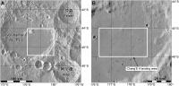
Chang'E 4 landing site:
https://www.chinaspaceflight.com/satellite/.../CE-4/CE-4.html Landing area - 45.5 degrees south latitude, 178 degrees east longitude This is on the flat floor of the large crater Von Karman, with a bit of ejecta from the relatively young crater Finsen. Until now most indications had been for a landing near the Apollo basin at about 42 south, 157 west (203 east). Phil -------------------- ... because the Solar System ain't gonna map itself.
Also to be found posting similar content on https://mastodon.social/@PhilStooke Maps for download (free PDF: https://upload.wikimedia.org/wikipedia/comm...Cartography.pdf NOTE: everything created by me which I post on UMSF is considered to be in the public domain (NOT CC, public domain) |
 |
 
|
|
Jun 11 2017, 08:24 PM
Post
#17
|
||
|
Solar System Cartographer Group: Members Posts: 10229 Joined: 5-April 05 From: Canada Member No.: 227 |
Here's a couple of maps showing the CE4 area.
Phil
-------------------- ... because the Solar System ain't gonna map itself.
Also to be found posting similar content on https://mastodon.social/@PhilStooke Maps for download (free PDF: https://upload.wikimedia.org/wikipedia/comm...Cartography.pdf NOTE: everything created by me which I post on UMSF is considered to be in the public domain (NOT CC, public domain) |
|
|
|
|
|
|
Jun 12 2017, 04:37 AM
Post
#18
|
|
|
Member Group: Members Posts: 316 Joined: 1-October 06 Member No.: 1206 |
Phil
I take it Von Karman's walls are sufficiently lofty to be visible in any surface imagery taken from inside that box? p |
|
|
|
|
Jun 12 2017, 05:35 AM
Post
#19
|
|
|
Senior Member Group: Members Posts: 2106 Joined: 13-February 10 From: Ontario Member No.: 5221 |
I wouldn't be so sure; the horizon is really close in the Chang'E 3 surface images. We shouldn't expect huge vistas anymore than we get them on Mars; cool terrain is by definition hazardous!
I would welcome being pleasant surprised to see anything more than a few km away, of course. |
|
|
|
|
Jun 12 2017, 05:16 PM
Post
#20
|
|
|
Solar System Cartographer Group: Members Posts: 10229 Joined: 5-April 05 From: Canada Member No.: 227 |
Short answer - I think some relief will be visible. Von Karman is about 3500 m deep and some distant topography should show up.
I will post something on the Chang'E 3 thread about distant topography. There are distant hills to the north and west at distances of 10 to 15 km, protruding above closer topography. To the east the horizon is about 4 km from the lander. Phil EDIT: OK, I posted in the other thread. That was a very flat site, but local high spots can be seen about 10 km away. I would expect that either the central peak of Von Karman or the SE wall of the crater should be visible from the lander, and possibly both will be, as well as small crater rims closer to the landing site. Not high mountains like Taurus-Littrow, but distant features should be visible, appearing as low hills. -------------------- ... because the Solar System ain't gonna map itself.
Also to be found posting similar content on https://mastodon.social/@PhilStooke Maps for download (free PDF: https://upload.wikimedia.org/wikipedia/comm...Cartography.pdf NOTE: everything created by me which I post on UMSF is considered to be in the public domain (NOT CC, public domain) |
|
|
|
|
Jul 6 2017, 06:01 PM
Post
#21
|
|
|
Solar System Cartographer Group: Members Posts: 10229 Joined: 5-April 05 From: Canada Member No.: 227 |
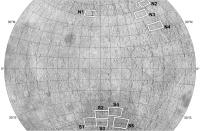
More information on site selection for CE4. This image:
https://www.chinaspaceflight.com/usr/upload...53834140857.jpg from this site: https://www.chinaspaceflight.com/satellite/.../CE-4/CE-4.html shows a number of sites at about 45 degrees north or south. I am preparing something on this topic, so I will post a map later. Some sites are in mare-type areas of the SPA basin or the large craters in that area, but the northern sites are all in or between large craters in the highlands (Mare Moscoviense is not one of these areas). This is from a presentation at the German Aerospace Centre DLR, where China and Germany have just agreed to cooperate on the mission, Germany joining several other countries. Phil -------------------- ... because the Solar System ain't gonna map itself.
Also to be found posting similar content on https://mastodon.social/@PhilStooke Maps for download (free PDF: https://upload.wikimedia.org/wikipedia/comm...Cartography.pdf NOTE: everything created by me which I post on UMSF is considered to be in the public domain (NOT CC, public domain) |
|
|
|
|
Jul 7 2017, 12:22 AM
Post
#22
|
||
|
Solar System Cartographer Group: Members Posts: 10229 Joined: 5-April 05 From: Canada Member No.: 227 |
Here is a map of those sites from the slide linked to above.
Phil
-------------------- ... because the Solar System ain't gonna map itself.
Also to be found posting similar content on https://mastodon.social/@PhilStooke Maps for download (free PDF: https://upload.wikimedia.org/wikipedia/comm...Cartography.pdf NOTE: everything created by me which I post on UMSF is considered to be in the public domain (NOT CC, public domain) |
|
|
|
|
|
|
Jul 7 2017, 01:32 AM
Post
#23
|
|
 Senior Member Group: Members Posts: 2530 Joined: 20-April 05 Member No.: 321 |
Probably everyone knows this, but on the Moon, the horizon is inherently closer than from a similar vantage point on Earth or Mars. Though the bowl of a crater may make the global curvature locally moot.
|
|
|
|
|
Jul 7 2017, 06:00 PM
Post
#24
|
|
|
Solar System Cartographer Group: Members Posts: 10229 Joined: 5-April 05 From: Canada Member No.: 227 |
That's true, of course, but the distance to the ideal horizon is not as important as the height and distance of significant relief features. Von Karman is about 160 km across and up to 4 km deep (wall height varies quite a bit). A good comparison might be with Flamsteed P, the flooded crater which Surveyor 1 landed in. It is 80 km across, but mostly filled with lava and with hills 1500 m high protruding above the plains. Hills 20 km away were visible in the Surveyor 1 panorama. Scaling up, I am confident there will be some relief on the CE4 horizon. Maybe if the landing is in exactly the worst place for viewing relief there would not be much, but from many areas some features will be visible.
Phil -------------------- ... because the Solar System ain't gonna map itself.
Also to be found posting similar content on https://mastodon.social/@PhilStooke Maps for download (free PDF: https://upload.wikimedia.org/wikipedia/comm...Cartography.pdf NOTE: everything created by me which I post on UMSF is considered to be in the public domain (NOT CC, public domain) |
|
|
|
|
Feb 27 2018, 07:49 PM
Post
#25
|
|
|
Solar System Cartographer Group: Members Posts: 10229 Joined: 5-April 05 From: Canada Member No.: 227 |
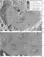
The Von Karman site may not be the final word on site selection... it was identified in a paper in 2017, but two papers by Jia et al. in 2018 (one in the Chinese Journal for Deep Space Exploration, the other in Planetary and Space Science, essentially the same content) prefer the site numbered S5 in the map a few posts above. It is south of the Apollo basin and closer to the centre of the SPA basin than any other of those mapped sites. I think all we have right now is competing suggestions, and the final target may still be uncertain.
Phil -------------------- ... because the Solar System ain't gonna map itself.
Also to be found posting similar content on https://mastodon.social/@PhilStooke Maps for download (free PDF: https://upload.wikimedia.org/wikipedia/comm...Cartography.pdf NOTE: everything created by me which I post on UMSF is considered to be in the public domain (NOT CC, public domain) |
|
|
|
|
Mar 18 2018, 06:09 PM
Post
#26
|
|
|
Solar System Cartographer Group: Members Posts: 10229 Joined: 5-April 05 From: Canada Member No.: 227 |
I'm at the Microsymposium just prior to LPSC. It just concluded, with presentations on the Chang'E program and others. Specifically for this thread, Von Karman seemed to be the likely site again - Apollo was promoted as a good site but probably for a future mission.
Phil -------------------- ... because the Solar System ain't gonna map itself.
Also to be found posting similar content on https://mastodon.social/@PhilStooke Maps for download (free PDF: https://upload.wikimedia.org/wikipedia/comm...Cartography.pdf NOTE: everything created by me which I post on UMSF is considered to be in the public domain (NOT CC, public domain) |
|
|
|
|
Apr 11 2018, 05:10 PM
Post
#27
|
|
|
Solar System Cartographer Group: Members Posts: 10229 Joined: 5-April 05 From: Canada Member No.: 227 |
Suggest a name for the CE4 relay satellite:
http://www.nssc.cas.cn/tzgg2015/tzgg_tzgg/...29_4987980.html (Google translation) Concerning the notification of the recruitment of the No. 4 relay star name Article Source: Release Time:2018-03-29 All relevant units: The fourth relay satellite will be launched in May 2018. Considering that the No. 4 mission will be the biggest bright spot in China's aerospace field in 2018, to further establish a good image of the lunar exploration project and expand the influence of the project, the Lunar Exploration and Space Engineering Center plans to use the project implementation unit as the main target for solicitation of No. 4 Relay star name. The No. 4 relay star name collection activity will take place from March 27 to April 15, 2018. The names so collected should reflect the theme of lunar exploration, have innovative and significant technological and cultural characteristics, be positive, and conform to the socialist core values. Specially invited your organization to participate in this solicitation. Please refer to the attachment for specific requirements. Attachment: Program for Selection of Relay No. 4 Relay Stars Moon Exploration and Aerospace Engineering Center March 27, 2018 -------------------- ... because the Solar System ain't gonna map itself.
Also to be found posting similar content on https://mastodon.social/@PhilStooke Maps for download (free PDF: https://upload.wikimedia.org/wikipedia/comm...Cartography.pdf NOTE: everything created by me which I post on UMSF is considered to be in the public domain (NOT CC, public domain) |
|
|
|
|
Apr 22 2018, 06:20 PM
Post
#28
|
|
|
Solar System Cartographer Group: Members Posts: 10229 Joined: 5-April 05 From: Canada Member No.: 227 |
This link is to the current issue of China's Journal of Deep Space Exploration:
http://jdse.bit.edu.cn/sktcxben/ch/reader/issue_list.aspx A very interesting set of papers about the CE4 landing site including several suggestions for landing sites and even rover traverse routes. Chinese language with English abstract, but Google document translation will help, and the illustrations carry a lot of information even without translation. Many of these papers will probably appear in English elsewhere at a later date. I can feel a map coming on... Phil -------------------- ... because the Solar System ain't gonna map itself.
Also to be found posting similar content on https://mastodon.social/@PhilStooke Maps for download (free PDF: https://upload.wikimedia.org/wikipedia/comm...Cartography.pdf NOTE: everything created by me which I post on UMSF is considered to be in the public domain (NOT CC, public domain) |
|
|
|
|
Apr 23 2018, 11:48 PM
Post
#29
|
||
|
Solar System Cartographer Group: Members Posts: 10229 Joined: 5-April 05 From: Canada Member No.: 227 |
After a suitable gestation period, here is a map of the sites suggested for Chang'E 4 in Von Karman crater. The references are from the previous post except the mention of Snape et al. (2010) which is an LPSC abstract, easy to search for if you need it. THe bottom map includes possible traverses suggested by Mou et al. (2018)
Phil
-------------------- ... because the Solar System ain't gonna map itself.
Also to be found posting similar content on https://mastodon.social/@PhilStooke Maps for download (free PDF: https://upload.wikimedia.org/wikipedia/comm...Cartography.pdf NOTE: everything created by me which I post on UMSF is considered to be in the public domain (NOT CC, public domain) |
|
|
|
|
|
|
Apr 24 2018, 02:38 AM
Post
#30
|
|
|
Solar System Cartographer Group: Members Posts: 10229 Joined: 5-April 05 From: Canada Member No.: 227 |
http://news.cnstock.com/news,bwkx-201804-4214240.htm
Google translate: China Securities News reported on April 24 from the National Bureau of Science, Technology, and Technology that during the opening ceremony of the "China Aerospace Day" home event in 2018, Wu Yanhua said that the Chang'e 4 is one of the major tasks for China's space industry this year... Wu Yanhua announced at the opening ceremony that the No. 4 relay star was named "Bianqiao" and the two small satellites were named "Longjiang No. 1" and "Longjiang No. 2". Phil -------------------- ... because the Solar System ain't gonna map itself.
Also to be found posting similar content on https://mastodon.social/@PhilStooke Maps for download (free PDF: https://upload.wikimedia.org/wikipedia/comm...Cartography.pdf NOTE: everything created by me which I post on UMSF is considered to be in the public domain (NOT CC, public domain) |
|
|
|
|

|
Lo-Fi Version | Time is now: 26th September 2024 - 01:54 PM |
|
RULES AND GUIDELINES Please read the Forum Rules and Guidelines before posting. IMAGE COPYRIGHT |
OPINIONS AND MODERATION Opinions expressed on UnmannedSpaceflight.com are those of the individual posters and do not necessarily reflect the opinions of UnmannedSpaceflight.com or The Planetary Society. The all-volunteer UnmannedSpaceflight.com moderation team is wholly independent of The Planetary Society. The Planetary Society has no influence over decisions made by the UnmannedSpaceflight.com moderators. |
SUPPORT THE FORUM Unmannedspaceflight.com is funded by the Planetary Society. Please consider supporting our work and many other projects by donating to the Society or becoming a member. |
|