Titan's Equatorial Sand Seas |

  |
Titan's Equatorial Sand Seas |
 May 22 2007, 06:02 PM May 22 2007, 06:02 PM
Post
#46
|
|
 Senior Member  Group: Moderator Posts: 2785 Joined: 10-November 06 From: Pasadena, CA Member No.: 1345 |
QUOTE (ngunn @ May 22 2007, 12:33 PM)  If we are saying that the equatorial basins once contained liquid then presumably tides could have caused much larger scale erosion features than just that small winding channel in Western Belet. Yup. That's what I'm thinking: 1. Basic morphology of the archipeligoes set up from impacts and crustal extensions (maybe even plate subductions?) 2. Grabens and basins partially filled up with eroded sands. 3. Bright stuff deposited from cryovolcanic venting. 4. Inundation with methane (removes lower parts of bright stuff, and sets up tidal channels which accentuates topography of grabens ("dancing monkey" of T28?). 5. Dune sands blowing around with the prevailing W wind. There may have been several cycles of inundation/tidal erosion and bright stuff deposition. If we see an obvious tidal channel (from RADAR) that is VIMS bright, we could argue that the particular tide channel was set in place in an earlier inundation/ocean event that occured BEFORE the last bright stuff deposition. (i.e. massive big huge inundation/tidal erosion-->bright stuff deposition-->big inundation leaves the lower bathtub ring). I have not seen any obvious signs of earlier pre-latest-bright-stuff shorelines or benches (except maybe the "Ghost Coast" area in NW Xanadu in the T13 RADAR swath). -Mike -------------------- Some higher resolution images available at my photostream: http://www.flickr.com/photos/31678681@N07/
|
 |
 
|
|
May 22 2007, 07:10 PM
Post
#47
|
|
 Member Group: Members Posts: 809 Joined: 11-March 04 Member No.: 56 |
Are the sand basins really very far below the surrounding light-colored regions? If they were liquid-filled, how deep would they be?
|
|
|
|
|
May 23 2007, 02:28 PM
Post
#48
|
|
|
Senior Member Group: Moderator Posts: 2785 Joined: 10-November 06 From: Pasadena, CA Member No.: 1345 |
QUOTE (David @ May 22 2007, 03:10 PM) Are the sand basins really very far below the surrounding light-colored regions? If they were liquid-filled, how deep would they be? Those are really, really good questions! How deep from "highest sea level since bright stuff deposition" to lowest sediment level in the basin? (How much liquid did the basins hold at the last flood event?) And also how deep is the dune/ice sand layer to the basin substrate? (How much sediment has washed in?) The only papers I have found with altimetry data tracks over Equatorial Sand Sea basins are: Soderblom et al Planetary and Space Science, 2007, article in press. (Topography of Huygens landing site areas) Sotin et al. Nature, 2005, 435, 786-789. (Topography of line offshore S of "Snail" feature in Shangri-La) Elachi et al. Science, 2005, 308, 970-974. (Topography of line in NE Fensal? (or did it just miss the basin?)) Rodriguez et al LPS (2007) Abstract (and figure) freely available here. (I think this is the same track as in Elachi paper - NE Fensal?) Does anyone know if there have been any other altimeter or topograhic data released of an Equatorial Sand Sea basin? -Mike -------------------- Some higher resolution images available at my photostream: http://www.flickr.com/photos/31678681@N07/
|
|
|
|
|
May 23 2007, 02:53 PM
Post
#49
|
|
|
Senior Member Group: Members Posts: 3516 Joined: 4-November 05 From: North Wales Member No.: 542 |
Another question, Mike. I'm looking at the 'sliced carrot'/'Mcnaught tail' feature to the north of Adiri. To me that looks like a wide ridge (possibly a very large ancient crater rim) eroded through in several places by tidal currents. The northeastern margin of Belet shows a lot of lineation trending roughly the same way which could also have arisen from somewhat more random original topography modified by tidal action. Does that fit with your picture?
|
|
|
|
|
May 23 2007, 03:16 PM
Post
#50
|
|
|
Member Group: Members Posts: 153 Joined: 14-August 06 Member No.: 1041 |
Excellant theory, Mike. If the sand dunes are still active - not frozen, we should see patterns change; and if the dunes are moving, the channels are likely being replowed, at least seasonally, by active tides. This is the best explanation I have seen for both the oddball flow patterns suggested by the 'channel', the connected 'lakes'; and the competing dune and gorge terrain.
|
|
|
|
|
May 23 2007, 03:23 PM
Post
#51
|
|
|
Senior Member Group: Moderator Posts: 2785 Joined: 10-November 06 From: Pasadena, CA Member No.: 1345 |
Ngunn, it fits pretty close.
I suspect that there may be some type of fracture/fault? lines that trend more or less E-W in many areas of equatorial Titan (the parallel "ski tracks" in the T8 swath are really curious). This might hasten erosion along the fracture/fault? lines (erosion first by rain, wind, then eventually tidal action during inundation). So the "sliced carrot" feature N of Adiri does look like the eastern wall of a crater that got eroded to the point of breakthrough. It'd be neat to see if there are any EW trending RADAR-dark tidal channels between the remaining ramparts. Here's a pretty cool abstract regarding streamlined features on Titan: Burr et al. LPS 36 (2005) "Theoretical calculations of sediment transport on Titan, and the possible production of streamlined forms." Abstract available freely here. The kicker quote: "Additionally or alternatively, streamlining could occur in hydrocarbon oceans due to coastal currents or basin scale circulation, in a manner analogous to streamlining in marine environments on Earth." If the ramparts do show tidal channels, I wonder if the E side of any islands in the channel are now streamlined? (So instead of a comet shape pointing W, maybe in these areas the currents shaped a symmetrical streamlined island so that the E side is also bullet shaped like the W.) -Mike -------------------- Some higher resolution images available at my photostream: http://www.flickr.com/photos/31678681@N07/
|
|
|
|
|
May 23 2007, 03:50 PM
Post
#52
|
|
|
Senior Member Group: Members Posts: 3516 Joined: 4-November 05 From: North Wales Member No.: 542 |
I certainly find these ideas plausible - and now you have some specific testable predictions at a specific location. Does the sliced carrot coincide with any planned RADAR swath as far as we know?
Thanks for that link. |
|
|
|
|
May 24 2007, 01:00 AM
Post
#53
|
|
 Senior Member Group: Members Posts: 1887 Joined: 20-November 04 From: Iowa Member No.: 110 |
Would the strength of these tides tides vary with latitude? If so I can see this as an additional reason for the lakes being concentrted at the poles. Stronger tides at low latitudes could result in liquid filled basins being enlarged by tidal motion. Eventually they could reach the point where increased evaporation or seepage caused them to dry up.
|
|
|
|
|
May 26 2007, 01:29 PM
Post
#54
|
|
 Member Group: Members Posts: 610 Joined: 23-February 07 From: Occasionally in Columbia, MD Member No.: 1764 |
QUOTE (alan @ May 23 2007, 09:00 PM) Would the strength of these tides tides vary with latitude? If so I can see this as an additional reason for the lakes being concentrted at the poles. Stronger tides at low latitudes could result in liquid filled basins being enlarged by tidal motion. Eventually they could reach the point where increased evaporation or seepage caused them to dry up. Yes - the strength varies with latitude (and longitude) - specifically with distance from the subsaturn point. A brief intro to tides on Titan and their effect on lakes (from 1993 - it includes some predicted landforms that, er, well, havent been borne out by observations so far, let's say - but it lays out some useful fundamentals) is at http://www.lpl.arizona.edu/~rlorenz/craterlakes.pdf Tides are generally weaker at high latitudes. I dont think tides explains why we find liquids where we do (but they may be responsible for the lack of wave-type features on shorelines like sandbars - tidal displacement of the waterline is larger than typical waveheight..) |
|
|
|
|
May 29 2007, 04:33 PM
Post
#55
|
|||||||||
|
Senior Member Group: Moderator Posts: 2785 Joined: 10-November 06 From: Pasadena, CA Member No.: 1345 |
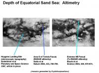
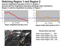
I used the published altimetry data to try and estimate the average depth of the Equatorial Sand Seas. The slides below show estimated traces adapted from released data.
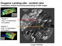
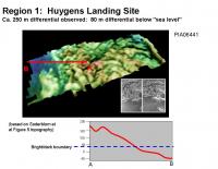
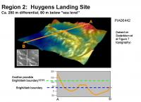
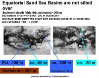
DISR image interpretation gave relative topographical maps of two regions near the Huygens Landing Site. Region 1 is the island, and Region 2 is one of the potholes of the sandbar in the offshore channel (the spooky dude formation. It is assumed that the absolute topographic elevation of the two determined regions (Region 1 and Region 2) is the same. In both regions, the bright/dark boundary was estimated to be at ca. 30 m in the referenced figures. [The highest points of the channel sandbar (region 2) are at 140 m above the bright/dark boundary. It is difficult to understand how a streambed deposit could have an elevation above the maximum sea level. (Unless maybe the sandbar was emplaced by an earlier and even higher inundation??) ]
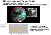
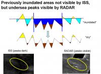
Altimetry data from the Shangri-La basin immediately S of Tortola Facula showed a series of parallel E-W ridges that varied by several hundred meters. Since these are not ISS-bright, they must lie below sea level, (below the bright/dark boundary). Thus, the elevations below sea level are estimated to be at least 0-200 m deep. [200 is minimal interpretation of several hundred meters]
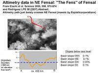
The Ta altimetry trace just crosses extreme NE Fesal. Altimetry shows a shallow dip, indicating that Fensal is very shallow in this area.
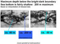
Maximum depths observed: Shangri-La basin (Huygens Landing site): at least 80 m deep Shangri-La basin (S of Tortola Facula): at least 200 m deep Extreme NE Fensal basin: 50 m deep With this limited data, it appears that the basins (or at least its edges) are fairly shallow. Thus during the last inundation, the basins would have resembled shallow seas, not deep oceans. -Mike -------------------- Some higher resolution images available at my photostream: http://www.flickr.com/photos/31678681@N07/
|
||||||||
|
|
|
||||||||
|
May 29 2007, 05:10 PM
Post
#56
|
|
 Senior Member Group: Members Posts: 2530 Joined: 20-April 05 Member No.: 321 |
QUOTE (Juramike @ May 29 2007, 09:33 AM) I used the published altimetry data to try and estimate the average depth of the Equatorial Sand Seas. The slides below show estimated traces adapted from released data. [...] With this limited data, it appears that the basins (or at least its edges) are fairly shallow. Thus during the last inundation, the basins would have resembled shallow seas, not deep oceans. -Mike Nice work. A companion analysis would be to say what kind of relief can be supported by H2O ice at these temperatures / acceleration due to gravity. Ganymede makes a very handy reference. DEMs from G1/G2 and from Voyager/G8 show delta-elevations of about 1500 m. Take that empirical result with a grain of salt or two -- the uplift could be different in the two cases, and Titan may not be in steady state. And moreover, the stereo coverage of Ganymede is extremely limited. Also, the sand seas should be able to make steep icy slopes more "buoyant" than when they are exposed to the vacuum of space. That could preserve some deeper gorges that are under "sea level". We shouldn't be surprised, though, if we find out that most of Titan's surface (including the icy surface submerged under sand seas) is within a range of 1500 meters or so of elevation. Since the sand seas occupy only a small fraction of the distribution [at the bottom, obviously], one would naively expect a depth that is a comparable fraction of the range. Eg, 1/10th of the range is about the bottom 150 meters. That happens to nail Juramike's estimates working from another direction. Given the sharp linear features around Aztlan in particular, perhaps there are some isolated "Marianas Trench" locales where the sand seas are particularly deep, but that wouldn't operate across their full breadth, for sure. |
|
|
|
|
May 29 2007, 06:18 PM
Post
#57
|
||||||||
|
Senior Member Group: Moderator Posts: 2785 Joined: 10-November 06 From: Pasadena, CA Member No.: 1345 |
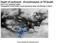
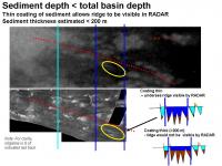
I used the "ski tracks" feature in the T8 swath to attempt to speculate on the depth of the sediments in W Shangri-La.
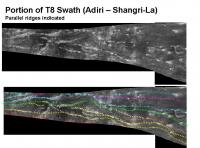
The bright terrain Adiri appears to be an upwarped terrain that was left above sea level during the last major inundation. There is an interesting series of parallel ridges in the T8 swath that run predominantly E-W along the southern margin of the Shangri-La basin and continue across Adiri. These ridges have been upwarped across Adiri (or downwarped to form the Shangri-La basin). In Adiri, the ridges are coated in bright material, but as one tracks eastward, the ridges slope gently down below sea level and the bright material is no longer present. Entering the Shangri-La basin, the ridges can not be discerned by ISS, but still remain visible in RADAR images. As the ridges begin reemerge above "sea level" further E, the ridges reappear in ISS imagery in the area to the N of Perkunas Virgae. (The ridges (and valleys) themselves are parallel to Bacab Virgae). Several of these ridges can be traced in the T8 swath. (I highlighted about 8 trending EW). Interestingly, the fault highlighted by Soderblom et al. on the island next to the Huygens Landing Site runs parallel to these ridgelines. It seems likely the island closest to the Huygens Landing Site is an exposed section of one of these ridges. Across the entire southern section of Shangri-La there are features that are oriented parallel to these ridges: these include Bacab Virgae, and the undersea parallel ridges S of Tortola Facula that were examined by altimetry.
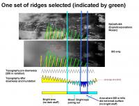
It seem reasonable to estimate that the that the ridges and valleys in the parallel system have elevation differences of 200-300 m. (Based on Huygens Island topography analysis 250 m and the similar set of EW undersea parallel ridges S of Tortola Facula that varied by several hundred meters). If we select one ridge in RADAR (green dashed line), we can follow it in ISS from the bright Adiri terrain into where it breaks up into exposed bright islands at the margin of Adiri (light blue line), until it disappears into Shangri-La (dark blue line), only to reemerge again into exposed bright islands (dark blue line). The light blue line shows where the valley was inundated (no more bright material on valley floor), and the dark blue line shows where the ridge tops were inundated (bright material removed even from ridgetops). Assuming the ridgeline to valley floor has an elevation difference of 200 m, the distance between the light blue line and the dark blue line can be used to derive the slope of the warp. This is approximately 200 m in 200 km, or 0.1%.
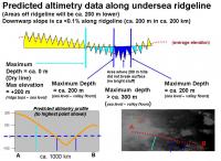
Extrapolating this slope into the "sea", we can estimate the depth of this section of Shangri-La basin. (In the slide, the red line is drawn in the valley just N and parallel to the ridgeline track in order to not obscure the ridge.) This would be estimated to be 100 m from sea level to ridgeline top. (Or 300 m from sea level to valley floor). An estimated (predicted) altimetry track is shown. [This track is close to the future T41 RADAR track]. These values are in the same ballpark as previously determined depths (above posts). The area bounded by the dark blue lines and along the ridgeline is highlighted in yellow. By ISS, no bright ridges are observed. This makes sense: from the above analysis, the ridgetops would have been inundated (by 100 m of solvent) , and no bright coating would be expected. But in this same area, ridges can be observed by RADAR. This implies that the ridge tops are RADAR-visible above the lower level of sediment or loose dune sands. Since the ridge tops are 200 m above the valley floor, that implies that the sediment layer lying on the valley floor is less than 200 m thick. (If the sediments were thicker than 200 m, the undersea ridges would not be visible by RADAR).
So the bottom line ( yup! I intened that!  ) is that the Equatorial Sand Seas are relatively shallow (compared to Earth) but are not silted over. ) is that the Equatorial Sand Seas are relatively shallow (compared to Earth) but are not silted over.-Mike -------------------- Some higher resolution images available at my photostream: http://www.flickr.com/photos/31678681@N07/
|
|||||||
|
|
|
|||||||
|
May 29 2007, 06:45 PM
Post
#58
|
||
 The Poet Dude Group: Moderator Posts: 5551 Joined: 15-March 04 From: Kendal, Cumbria, UK Member No.: 60 |
Fascinating reading as always Juramike, thanks. You put a lot of effort into those posts, and it's appreciated.
I'm interested to hear what you think this feature - I think it's been called "the Spaghetti" somewhere here - actually is?
Silted-up drainage channels? Faults? Cryo-volcano run-offs? 
-------------------- |
|
|
|
|
|
|
May 29 2007, 07:17 PM
Post
#59
|
|
|
Senior Member Group: Moderator Posts: 2785 Joined: 10-November 06 From: Pasadena, CA Member No.: 1345 |
My WAG about the "dancing monkey" or "spaghetti" feature is that faulting, erosion, inundation, and cryo-volcanism were all players.
1. Faulting makes a bunch of grabens. (generally trending EW) 2. Erosion during methane rainstorms and inundations occur. (Tidal flushing a factor interconnecting the lines?) 3. A cryovolcano somewhere (Xanadu?) coughs up bright material that gets distributed all over. Bright stuff deposited. (My wild suspicion is that Xanadu is a major cryovolcanic complex and coughs bright material that distributes mostly in the equatorial/mid latitude region. I suspect Xanadu on Titan is the equivalent of Tharsis on Mars). 4. The last major indundation occurs and strips bright stuff below "sea level". Dark blue ice sand sediments washed in to basins. (Are any blown in? VIMS could provide evidence by seeing if any of the dark brown dune sands are present in the bottom) I'm not sure what made initial graben as a series of curvy cross cut patterns in this area compared to the straight lines in other areas. Maybe a comparison can be drawn with Callisto, Ganymede, and Europa with regards to the formation of ridges and grooves seen on those icy moons? -Mike -------------------- Some higher resolution images available at my photostream: http://www.flickr.com/photos/31678681@N07/
|
|
|
|
|
Jun 4 2007, 04:31 PM
Post
#60
|
||||||||
|
Senior Member Group: Moderator Posts: 2785 Joined: 10-November 06 From: Pasadena, CA Member No.: 1345 |
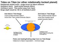
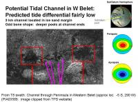
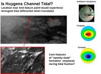
QUOTE (rlorenz @ May 26 2007, 09:29 AM) A brief intro to tides on Titan and their effect on lakes (...) is at http://www.lpl.arizona.edu/~rlorenz/craterlakes.pdf I attempted to relate the tide effects mentioned above and in other (papers you gotta pay for) to the Channel in W Belet. Here are the non-free references: Sagan and Dermott Nature 1982, 300, 731-733. "The tide in the seas of Titan". Dermott and Sagan Nature 1995, 374, 238-240. "Tidal effects of disconnected hydrocarbon seas on Titan". Tokano and Neubauer Icarus 2002, 158-499-515. "Tidal Winds on Titan Caused by Saturn." The figures attached describe the tidal effects of tidally locked planet with significant orbital eccentricity and a global ocean. (e.g. Titan, but with a global ocean):
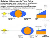
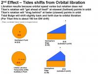
The tidal bulge is set by the gravitational attraction by the influencing body (e.g. Saturn on Titan). At the sub-Saturn point, Saturn pulls on the hydrocarbon ocean since the ocean is closer to Saturn than the core of Titan. (Think of it as Saturn trying to accelerate the ocean away from Titan). At the anti-Saturn point, Saturn pulls on the core of Titan more than the hydrocarbon carbon ocean which is further from Saturn. (Think of it as Saturn trying to accelerate Titan away from the ocean.) At the poles and hemisphere edges, the ocean is at the same relative distance from Saturn and the core of Titan, so there is no bulge at these locations. (For more info, check out: http://en.wikipedia.org/wiki/Tidal_bulge http://home.hiwaay.net/~krcool/Astro/moon/moontides/ ) Since Titan is tidally locked, and the same point (more or less) faces Saturn, the tidal bulge is pretty much frozen in place. From Sagan et al. the tidal bulge of a theoretical global hydrocarbon ocean on Titan would be 120 m higher at the sub-Saturn point and at the anti-Saturn point. The tide is set by the relative height differential of the tidal bulge. If Titans orbit were perfectly circular, there would be no difference and the sub-Saturn point tidal bulge would always be at 120 m. So no differential, thus no tide. But Titan has an eccentric orbit. (e = 0.0289). When Saturn is closer to Titan, the tidal bulges are more accentuated than when it is farther away. This is by 9% (3e = 3 x 0.0289), or 9 m higher at the sub-Saturn point. When Saturn is farther away, the bulge is lower by 9 m. But since the liquid volume is fixed, the excess mass gets distributed to the remainder of the ocean. So the ocean height at the hemisphere edge increases (slightly all that 9 m of bulge differential is distributing over a much, much larger area). This increase would be the local high tide at the periphery of the hemisphere and poles. There will also be a point of inflection that would not experience any tidal differential. In addition, there is a slight effect due to orbital libration. This causes a drift along the equator of 150 km of the tidal bulge of the sub-Saturn (and thus anti-Saturn) points. This would result from the rotation of Titan being fixed but the orbital speed is variable. At it reaches periapsis, Titan is zipping along and the rotation will be dragging behind. As it whips around the periapsis point, the rotation is still slower so the Tidal bulge will appear to move forward. The net effect will be to ratchet the Tidal Bulge forward (eastward) a small amount. There would be a similar drift westward at the far end of the orbit for the same reason, but the effect will be much smaller (since the bulge will be smaller at apoapsis). This will also smear the Tidal Bulge along the EW direction.
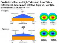
Combining these effects we get a theoretical picture of the global ocean height at periapsis (closest to Saturn) and apoapsis (farthest from Saturn). The sub-Saturn and anti-Saturn point will have the largest effect (9 m!). The poles and hemisphere edges will have a much smaller effect (<9 m) and there will be zone of inflection with no differential is shown in green. This model is assuming a global ocean. On Titan, it appears that there were multiple shallow sea basins that were flooded during the last major inundation. That means that any relaxation of tidal volume from a bulge at one end of a sea would need to be taken up at the other end of the sea. For example, the Anti-Saturn point is at the W end of Shangri-La basin; as Titans orbit swings farther from Saturn, the liquid under the tidal bulge would be somewhat redistributed to the farther parts of the Shangri-La basin (and would also try to redistribute to other connected basins, such as Ching-Tu and Belet). From the logic above, the best places to look for tidal channels would be nearest the sub-Saturn and anti-Saturn points in the narrow constrictions between basins or archipeligos.
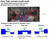
In the Anti-Saturn hemisphere, the dark areas between Dilmun and Adiri (the channel between Shangri-La and Belet) should be a really good place to look for tidal channels (sliced carrot feature?). Another place would be the passages connecting Shangri-La and Ching Tu, as well as Ching-Tu and Belet. (Is the Huygens channel a former tidal channel? Its location fits nicely with predicted tidal differentials!) . In the Sub-Saturn hemisphere, narrow channels between Aztlan and Aaru, narrow channels between Aztlan and Fensal (extreme E Quivra) and Senkyo/Fensal and Aaru/Senkyo would be interesting to check out. The areas between Senkyo and Belet may be also of some interest. The possible Tidal channel in W Belet is located in an area that may not have the largest possible tidal differential. (But heck, the potential Earth analog, Deception Pass, gets an impressive flush from only a 1.5 m tide height differential.) The poles should have almost zero tides, especially if they are/were disconnected from any bodies of liquid involved in the SubSaturn or AntiSaturn Tidal Bulges. Other effects that may influence tidal flushes include both sea bottom topography and tidal resonances. -Mike -------------------- Some higher resolution images available at my photostream: http://www.flickr.com/photos/31678681@N07/
|
|||||||
|
|
|
|||||||
|

|
Lo-Fi Version | Time is now: 11th May 2024 - 01:50 PM |
|
RULES AND GUIDELINES Please read the Forum Rules and Guidelines before posting. IMAGE COPYRIGHT |
OPINIONS AND MODERATION Opinions expressed on UnmannedSpaceflight.com are those of the individual posters and do not necessarily reflect the opinions of UnmannedSpaceflight.com or The Planetary Society. The all-volunteer UnmannedSpaceflight.com moderation team is wholly independent of The Planetary Society. The Planetary Society has no influence over decisions made by the UnmannedSpaceflight.com moderators. |
SUPPORT THE FORUM Unmannedspaceflight.com is funded by the Planetary Society. Please consider supporting our work and many other projects by donating to the Society or becoming a member. |
|