Along the base of Vera Rubin Ridge, (Sites 64-65, Sols 1726-1812, Jun 14-Sep 11 2017) |

  |
Along the base of Vera Rubin Ridge, (Sites 64-65, Sols 1726-1812, Jun 14-Sep 11 2017) |
 Jul 1 2017, 04:33 AM Jul 1 2017, 04:33 AM
Post
#61
|
||
 Senior Member  Group: Members Posts: 2428 Joined: 30-January 13 From: Penang, Malaysia. Member No.: 6853 |
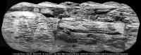
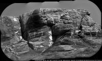
Sol 1741 RMI mosaic featuring the stratigraphy of another section of the Vera Rubin Ridge, not sure about scale, but I estimate the distance to be around 80-85 meters South of the rover (distance depends on its position on the slope). There was another RMI frame, sadly that had data drop-out, not sure if it belonged to the same set or a different section. Assembled in MS ICE and rotated, not sharpened or processed other than stitching in MS ICE.
|
|
 |
 
|
|
|
Jul 1 2017, 05:40 AM
Post
#62
|
|
 Senior Member Group: Members Posts: 1421 Joined: 26-July 08 Member No.: 4270 |
Has there been any consideration of looking at Phobos through ChemCam? It's certainly something I would do if I were on Mars with a telescope.
-------------------- -- Hungry4info (Sirius_Alpha)
|
|
|
|
|
Jul 1 2017, 09:30 AM
Post
#63
|
|
|
Senior Member Group: Members Posts: 2428 Joined: 30-January 13 From: Penang, Malaysia. Member No.: 6853 |
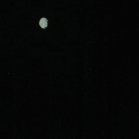
A simple animation (GIF) of Phobos imaged during the early hours of sol 1730 (13 frames) the timing of each frame varies towards the end of the animation, maybe more frames are in the pipeline? The mission update tells us this was done to help measure the dust in the upper atmosphere...
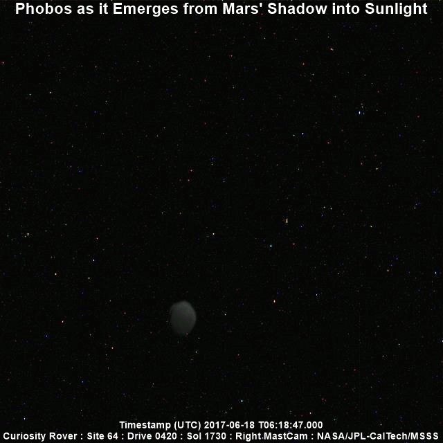 To run the animation full size Link |
|
|
|
|
Jul 1 2017, 04:22 PM
Post
#64
|
|
|
Member Group: Members Posts: 122 Joined: 19-June 07 Member No.: 2455 |
|
|
|
|
|
Jul 2 2017, 01:37 PM
Post
#65
|
||
|
Senior Member Group: Members Posts: 2820 Joined: 22-April 05 From: Ridderkerk, Netherlands Member No.: 353 |
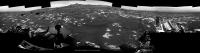
The Navcam L view on Sol 1741.
Jan van Driel
|
|
|
|
|
|
|
Jul 2 2017, 06:20 PM
Post
#66
|
|
|
Solar System Cartographer Group: Members Posts: 10153 Joined: 5-April 05 From: Canada Member No.: 227 |
"Has there been any consideration of looking at Phobos through ChemCam? It's certainly something I would do if I were on Mars with a telescope."
Yes - but it's tricky. See this discussion: http://www.unmannedspaceflight.com/index.p...7730&st=285 Phil -------------------- ... because the Solar System ain't gonna map itself.
Also to be found posting similar content on https://mastodon.social/@PhilStooke Maps for download (free PD: https://upload.wikimedia.org/wikipedia/comm...Cartography.pdf NOTE: everything created by me which I post on UMSF is considered to be in the public domain (NOT CC, public domain) |
|
|
|
|
Jul 3 2017, 01:34 PM
Post
#67
|
|
|
Senior Member Group: Members Posts: 2428 Joined: 30-January 13 From: Penang, Malaysia. Member No.: 6853 |
QUOTE (Phil Stooke @ Jul 3 2017, 02:20 AM)  Yes - but it's tricky. See this discussion... Note: Those RMIs are from sol 741 (in case anyone is chasing down the PDS images) Also note: That discussion took place ~1000 sols ago. Time flies for sure... Seems like a couple of months ago 
|
|
|
|
|
Jul 3 2017, 10:38 PM
Post
#68
|
||
|
Senior Member Group: Members Posts: 2428 Joined: 30-January 13 From: Penang, Malaysia. Member No.: 6853 |
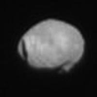
1736 R-MastCam animated GIF (unprocessed raw files) with a sharper view of Stickney
Link to full size version on Imgur: Link |
|
|
|
|
|
|
Jul 3 2017, 11:39 PM
Post
#69
|
||
|
Solar System Cartographer Group: Members Posts: 10153 Joined: 5-April 05 From: Canada Member No.: 227 |
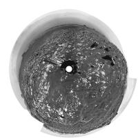
Nice! Here is an enlarged view, north at the top, a merge of five frames.
Phil
-------------------- ... because the Solar System ain't gonna map itself.
Also to be found posting similar content on https://mastodon.social/@PhilStooke Maps for download (free PD: https://upload.wikimedia.org/wikipedia/comm...Cartography.pdf NOTE: everything created by me which I post on UMSF is considered to be in the public domain (NOT CC, public domain) |
|
|
|
|
|
|
Jul 4 2017, 03:07 AM
Post
#70
|
||
|
Solar System Cartographer Group: Members Posts: 10153 Joined: 5-April 05 From: Canada Member No.: 227 |
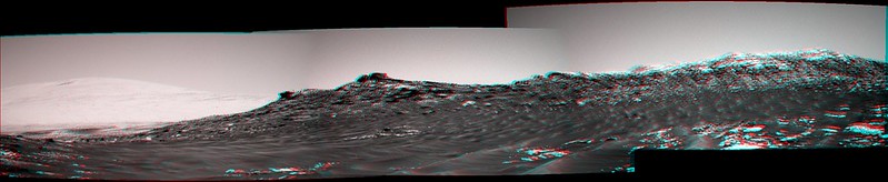
Jan's sol 1741 panorama in circular form. Compared with the last one (previous page) we are much closer to the prominent blocks.
Phil
-------------------- ... because the Solar System ain't gonna map itself.
Also to be found posting similar content on https://mastodon.social/@PhilStooke Maps for download (free PD: https://upload.wikimedia.org/wikipedia/comm...Cartography.pdf NOTE: everything created by me which I post on UMSF is considered to be in the public domain (NOT CC, public domain) |
|
|
|
|
|
|
Jul 4 2017, 08:15 AM
Post
#71
|
|
|
Member Group: Members Posts: 923 Joined: 10-November 15 Member No.: 7837 |
I refreshed my workflow for these simulated clips of Curiosity driving around HiRISE models mapped to mosaics...click thru for a video of Curi climbing Vera on Sol 1732.
 I'll take a look at the speed & suspension on the next one. -------------------- |
|
|
|
|
Jul 4 2017, 01:10 PM
Post
#72
|
||
|
Senior Member Group: Members Posts: 2428 Joined: 30-January 13 From: Penang, Malaysia. Member No.: 6853 |
A 4th of July Special from Curiosity, in the form of a long range 10 frame RMI mosaic featuring another section of the Vera Rubin Ridge. Rather nice for MS ICE, I'm hoping that rash statement will inspire others to have a go at this one
There is another 10 frame mosaic, but that will have to await my morrow. Happy 4th to all that are celebrating the original Brexit V1 (1776 version)
|
|
|
|
|
|
|
Jul 4 2017, 03:21 PM
Post
#73
|
|
 Senior Member Group: Members Posts: 1629 Joined: 5-March 05 From: Boulder, CO Member No.: 184 |
QUOTE (Sean @ Jul 4 2017, 08:15 AM) I refreshed my workflow for these simulated clips of Curiosity driving around HiRISE models mapped to mosaics...click thru for a video of Curi climbing Vera on Sol 1732. Interesting to see this Sean. Is Curiosity in your video climbing at a point SW of Northern Neck? I wonder what the slope is there (and traversing later beyond the field of view). My guess would be that a gentler climb is possible in the relative trough just to the east of Northern Neck, though still west of the notional route mentioned recently by Fernando. This would be after circling around the east side of the drifts. I suppose one could look at a slope map and figure out what path across the ridge has the lowest value of maximum up/down slope. This is what I had roughly done earlier by eye with your 3D interactive view. -------------------- Steve [ my home page and planetary maps page ]
|
|
|
|
|
Jul 4 2017, 04:05 PM
Post
#74
|
|
|
Member Group: Members Posts: 923 Joined: 10-November 15 Member No.: 7837 |
Yes Steve, you can see this on the model also...
Vera Rubin Ridge @Sketchfab  The planned route does offer what appears to be the best entry point to the Ridge, with the possible exit not far away to the south east. 
-------------------- |
|
|
|
|
Jul 5 2017, 08:45 AM
Post
#75
|
||
|
Senior Member Group: Members Posts: 2428 Joined: 30-January 13 From: Penang, Malaysia. Member No.: 6853 |
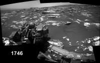
Drive to site 64/1890 on sol 1746, duration >50 minutes (MS-ICE with L-NavCam)
Not many frames yet, but this may help to identify the location
Edit: Several additional frames are down now (including a few of the top tier), but MS ICE can't cope with the sandy ripples (great pity). Midnight Planets reports the drive as ~22 meters East (100º) on Sol 1746. The direct path looks like an obstacle course, so they may head a little further East before going south? Whichever way they go, looks like there are no shortage of ground targets between the drives to the entry ramp
|
|
|
|
|
|
|

|
Lo-Fi Version | Time is now: 27th April 2024 - 07:10 PM |
|
RULES AND GUIDELINES Please read the Forum Rules and Guidelines before posting. IMAGE COPYRIGHT |
OPINIONS AND MODERATION Opinions expressed on UnmannedSpaceflight.com are those of the individual posters and do not necessarily reflect the opinions of UnmannedSpaceflight.com or The Planetary Society. The all-volunteer UnmannedSpaceflight.com moderation team is wholly independent of The Planetary Society. The Planetary Society has no influence over decisions made by the UnmannedSpaceflight.com moderators. |
SUPPORT THE FORUM Unmannedspaceflight.com is funded by the Planetary Society. Please consider supporting our work and many other projects by donating to the Society or becoming a member. |
|