MSL Route Map |

  |
MSL Route Map |
 Jul 6 2019, 12:42 AM Jul 6 2019, 12:42 AM
Post
#1306
|
|
 Member  Group: Members Posts: 684 Joined: 24-July 15 Member No.: 7619 |
QUOTE (Gerald @ Jul 5 2019, 10:22 PM)  The fractal dimension is scale-dependent and varying with the location. Moreover, Curiosity's wheels are smoothing topographic features smaller than the radius of the wheels, such that we'll get a pretty well-defined two-dimensional manifold on the scale of Curiosity's wheels. Think of the envelope or hull defined by a sphere of the same radius as the wheels placed at any point of the (fractal) surface. Call smaller topographic features roughness or texture, and separate it from the just-defined smooth 2D hull. The only remaining uncertainty is soft surface material like dust or pebbles potentially displaced by the rover. Formally, this could be described by error bounds like any empirical measurement. We don't run into 2D infinities for the smoothed surface. Yep, The distance measured? Depends on the size of the wheel that is doing the measuring. From that data, you determine the fractal dimension of the material that you are crossing. Fair-to-middling-chance that such information might reveal something about the sediment you are traversing. Basically, the human foot informs you about the fractional dimensions of what you are walking on: concrete, asphalt, packed stone, soil, wet sand or dry sand. Each one feels "different' even if you are wearing shoes. (Perhaps the next rover should have "toes" to better sample the soil it crosses) Curiosity has six feet, with a bit of data mining, it should be able to determine the "fractal feel" of the material it "walks over". |
 |
 
|
|
Jul 6 2019, 09:12 PM
Post
#1307
|
|
|
Member Group: Members Posts: 684 Joined: 24-July 15 Member No.: 7619 |
Fractal dimension as a way to understand the shallow structural geology in heavily eroded landscapes.
QUOTE FRACTAL INTERRELATIONSHIPS BETWEEN TOPOGRAPHY AND STRUCTURE
Earth Surf. Process. Landforms 23, 509–525 (1998) Fractal interrelationships between topography and structure are investigated in two areas of the North American central Appalachian Mountains: one in the intensely deformed Valley and Ridge province and the other in the relatively undeformed foreland area of the Appalachian Plateau province. In the Valley and Ridge province, the fractal dimensions of topographic and structural relief vary systematically along the strike of major folds following a second-order polynomial trend. Cross-correlation of the fractal dimensions of topography to structure indicates that there is a significant positive correlation between the two. Fractal analysis of topography in the relatively undeformed foreland area of the Appalachian Plateau revealed no significant variation in the fractal characteristics of topography across the study area, consistent with the lack of near-surface structure. However, fractal analysis of deeper structures beneath the Plateau area undertaken using reflection seismic data revealed stepwise increases in fractal dimension from the deeply buried Precambrian basement to the near-surface. These vertical changes in the fractal dimension can be related to the tectonic history of the area. Taken together, these studies indicate that fractal analysis provides a means to quantify and compare the influence of near-surface structure on topographic development and lateral and vertical structural variability. The fractal analysis provides a means to characterize the systematic changes in the complex patterns formed by topography and structure and the interrelationships between them. The similarity in their fractal characteristics implies similarity in the relative amplitude and abundance of different wavelength features in the topographic or structural profile ... CONCLUSIONS Topographic and structural relief examined in this study exhibit fractal behavior as defined by roughness–length and compass estimates of fractal dimension. Studies conducted in intensely and mildly deformed tectonic environments of the North American Appalachian Mountains suggest that the presence or absence of variation in the fractal characteristics of surface topography are, in part, related to presence or absence of variations in the fractal characteristics of the near-surface structure. The result is not surprising since subsurface structure distributes rocks of contrasting mechanical properties across the Earth’s surface. The various processes of weathering and erosion then differentially etch topography into the Earth’s surface according to the mechanical and chemical properties of the near-surface rock intervals. The use of fractals to compare topography and structure is preferred over regression line analysis since the fractal characteristics of a profile provide specific information about the abundance and relative amplitude of features in the profiles, whereas direct correlation of topographic and structural relief does not provide specific insight into properties that give rise to similarity. http://pages.geo.wvu.edu/~wilson/pubs/Frac...ntsESPL1998.pdf |
|
|
|
|
Jul 8 2019, 05:37 PM
Post
#1308
|
||
|
Solar System Cartographer Group: Members Posts: 10146 Joined: 5-April 05 From: Canada Member No.: 227 |
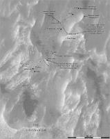
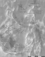
A small move on sol 2459 is recorded in this new version of the map.
Phil
-------------------- ... because the Solar System ain't gonna map itself.
Also to be found posting similar content on https://mastodon.social/@PhilStooke NOTE: everything created by me which I post on UMSF is considered to be in the public domain (NOT CC, public domain) |
|
|
|
|
|
|
Jul 8 2019, 06:28 PM
Post
#1309
|
|
 Member Group: Members Posts: 883 Joined: 15-June 09 From: Lisbon, Portugal Member No.: 4824 |
Following Phil's suggestion I measured 1 degree arcs along the 0 meridian at latitudes of 0, 15, 30, 45, 60, and 75 degrees. I also measured 1 degree arcs along several parallels, between 0ºE and 1ºE at the same latitudes. Measurements were made with the GE ruler and having the arc's end-points fully zoomed in (eye altitude of 7m). The results are... interesting.
From the measured arc's length the radius can be derived. Oddly, I obtained an equatorial radius approximately equal to the known polar radius (3,376,200 m). As expected, the arc segment's length along the parallels steadily diminished from the equator to 75ºN, by a factor of nearly 4, but did not follow too closely the scale of cos(lat) Phil mentions. As for the meridian arcs, their measured lengths increased with the latitude. Having the derived radius increase with the latitude seems to imply an ellipsoid like a rugby ball with the big axis vertical. Strange. Here is the arc-generating kml file:  TestGrid.kml ( 6.85K )
Number of downloads: 216
TestGrid.kml ( 6.85K )
Number of downloads: 216and the measurement data:  TestGrid.txt ( 1.16K )
Number of downloads: 199
TestGrid.txt ( 1.16K )
Number of downloads: 199All of those measurements depend on how good GE's ruler is. I found the following on the measurement accuracy of the Google Earth ruler: https://gis.stackexchange.com/questions/951...oogle-earth-pro https://gis.stackexchange.com/questions/103...in-google-earth Now what? For the time being I'm sticking with that 1% deficient grid, unless you vote it completely unacceptable. Cheers. Fernando |
|
|
|
|
Jul 8 2019, 11:38 PM
Post
#1310
|
|
|
Senior Member Group: Members Posts: 2346 Joined: 7-December 12 Member No.: 6780 |
QUOTE (nogal @ Jul 8 2019, 07:28 PM) As expected, the arc segment's length along the parallels steadily diminished from the equator to 75ºN, by a factor of nearly 4, but did not follow too closely the scale of cos(lat) Phil mentions. You may need a correction factor of (r_p / r_e)^2, with r_p the polar radius, and r_e the equatorial radius of the approximate Mars spheroid for the tan of your lat value, if coordinates are given in terms of planetographic latitudes. For some more detail, see e.g. the code in this Q&A. |
|
|
|
|
Jul 9 2019, 01:05 AM
Post
#1311
|
|
|
Member Group: Members Posts: 883 Joined: 15-June 09 From: Lisbon, Portugal Member No.: 4824 |
Thanks Gerald. This apprentice skater has ventured out on the surface of this lake, ignorant of its depth, and now feels the ice cracking under his skates....
Fernando |
|
|
|
|
Jul 16 2019, 02:36 AM
Post
#1312
|
||
|
Solar System Cartographer Group: Members Posts: 10146 Joined: 5-April 05 From: Canada Member No.: 227 |
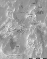
I should add that my cosine rule was an approximation for a sphere.
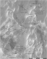
Map update to sol 2466 showing a nice drive to the south. I'm not sure my name 'Aitken Pit' is in the right place. Phil
-------------------- ... because the Solar System ain't gonna map itself.
Also to be found posting similar content on https://mastodon.social/@PhilStooke NOTE: everything created by me which I post on UMSF is considered to be in the public domain (NOT CC, public domain) |
|
|
|
|
|
|
Jul 18 2019, 10:03 PM
Post
#1313
|
||
|
Solar System Cartographer Group: Members Posts: 10146 Joined: 5-April 05 From: Canada Member No.: 227 |
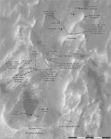
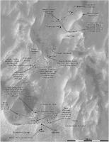
Here is a map update for sol 2468. We are on the rocks beside Aitken Pit (if the name belongs there).
Phil
Attached thumbnail(s)
-------------------- ... because the Solar System ain't gonna map itself.
Also to be found posting similar content on https://mastodon.social/@PhilStooke NOTE: everything created by me which I post on UMSF is considered to be in the public domain (NOT CC, public domain) |
|
|
|
|
|
|
Jul 23 2019, 10:33 PM
Post
#1314
|
||
|
Solar System Cartographer Group: Members Posts: 10146 Joined: 5-April 05 From: Canada Member No.: 227 |
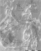
This update includes the drive to the sol 2473-2474 position.
Phil
-------------------- ... because the Solar System ain't gonna map itself.
Also to be found posting similar content on https://mastodon.social/@PhilStooke NOTE: everything created by me which I post on UMSF is considered to be in the public domain (NOT CC, public domain) |
|
|
|
|
|
|
Jul 25 2019, 06:58 PM
Post
#1315
|
||
|
Solar System Cartographer Group: Members Posts: 10146 Joined: 5-April 05 From: Canada Member No.: 227 |
Update to sol 2476, where we are at the Southern Outcrop.
Phil
-------------------- ... because the Solar System ain't gonna map itself.
Also to be found posting similar content on https://mastodon.social/@PhilStooke NOTE: everything created by me which I post on UMSF is considered to be in the public domain (NOT CC, public domain) |
|
|
|
|
|
|
Jul 28 2019, 07:24 PM
Post
#1316
|
||
|
Solar System Cartographer Group: Members Posts: 10146 Joined: 5-April 05 From: Canada Member No.: 227 |
Sol 2477, climbing onto the outcrop.
Phil
-------------------- ... because the Solar System ain't gonna map itself.
Also to be found posting similar content on https://mastodon.social/@PhilStooke NOTE: everything created by me which I post on UMSF is considered to be in the public domain (NOT CC, public domain) |
|
|
|
|
|
|
Jul 31 2019, 10:33 PM
Post
#1317
|
||
|
Solar System Cartographer Group: Members Posts: 10146 Joined: 5-April 05 From: Canada Member No.: 227 |
Sol 2481, on the edge of the outcrop looking for a drill site.
Phil
-------------------- ... because the Solar System ain't gonna map itself.
Also to be found posting similar content on https://mastodon.social/@PhilStooke NOTE: everything created by me which I post on UMSF is considered to be in the public domain (NOT CC, public domain) |
|
|
|
|
|
|
Aug 6 2019, 10:20 PM
Post
#1318
|
|
|
Member Group: Members Posts: 883 Joined: 15-June 09 From: Lisbon, Portugal Member No.: 4824 |
Happy Anniversary Curiosity! 7 Earth years on Mars!
Update to sol 2481. Both the 16 miles and the 21 km marks are already in the "rear mirror". The problem with the distance grid is solved. Thanks again to Phil and Gerald for the information shared here. Fernando
The_Martian_Way_MSL_Curiosity_Sol_2481_2019AUG06.kmz ( 748.08K )
Number of downloads: 252 |
|
|
|
|
Aug 7 2019, 01:53 AM
Post
#1319
|
|
 Senior Member Group: Members Posts: 2425 Joined: 30-January 13 From: Penang, Malaysia. Member No.: 6853 |
QUOTE (nogal @ Aug 7 2019, 06:20 AM) Update to sol 2481. Both the 16 miles and the 21 km marks are already in the "rear mirror". Works like a charm  Thanks Fernando Thanks Fernando
|
|
|
|
|
Aug 7 2019, 05:51 PM
Post
#1320
|
|
|
Member Group: Members Posts: 883 Joined: 15-June 09 From: Lisbon, Portugal Member No.: 4824 |
Many thanks for the feedback Paul
Fernando |
|
|
|
|

|
Lo-Fi Version | Time is now: 19th April 2024 - 03:41 PM |
|
RULES AND GUIDELINES Please read the Forum Rules and Guidelines before posting. IMAGE COPYRIGHT |
OPINIONS AND MODERATION Opinions expressed on UnmannedSpaceflight.com are those of the individual posters and do not necessarily reflect the opinions of UnmannedSpaceflight.com or The Planetary Society. The all-volunteer UnmannedSpaceflight.com moderation team is wholly independent of The Planetary Society. The Planetary Society has no influence over decisions made by the UnmannedSpaceflight.com moderators. |
SUPPORT THE FORUM Unmannedspaceflight.com is funded by the Planetary Society. Please consider supporting our work and many other projects by donating to the Society or becoming a member. |
|