McCool Hill |

  |
McCool Hill |
 Mar 12 2006, 09:24 PM Mar 12 2006, 09:24 PM
Post
#1
|
||
|
Senior Member  Group: Members Posts: 2819 Joined: 22-April 05 From: Ridderkerk, Netherlands Member No.: 353 |
It is time for a new thread now Spirit is on it's way to McCool Hill to survive the Marsian winter.
Here is a panorama from McCool Hill taken on Sol 777 with the R2 pancam. Almost from the same place as the panorama taken on Sol 776. jvandriel
Attached thumbnail(s)
|
|
 |
 
|
|
|
Mar 12 2006, 11:17 PM
Post
#2
|
|
|
Junior Member Group: Members Posts: 67 Joined: 18-April 05 From: Austin, Texas Member No.: 249 |
Anyone want to hazard a guess as to her path up McCool Hill?
Phillip |
|
|
|
|
Mar 13 2006, 03:05 AM
Post
#3
|
|
|
Senior Member Group: Members Posts: 2998 Joined: 30-October 04 Member No.: 105 |
The route is under discussion at :
http://www.unmannedspaceflight.com/index.php?showtopic=2326 My speculation is at: http://www.unmannedspaceflight.com/index.p...indpost&p=44205 --Bill -------------------- |
|
|
|
|
Mar 13 2006, 12:29 PM
Post
#4
|
|
 Member Group: Members Posts: 362 Joined: 12-June 05 From: Kiama, Australia Member No.: 409 |
QUOTE (Phillip @ Mar 13 2006, 10:17 AM)  Anyone want to hazard a guess as to her path up McCool Hill? Phillip I think the boundary of the lighter colored deposits on the hill will feature prominently in the path chosen |
|
|
|
|
Mar 13 2006, 07:02 PM
Post
#5
|
|
 Senior Member Group: Members Posts: 1229 Joined: 24-December 05 From: The blue one in between the yellow and red ones. Member No.: 618 |
QUOTE (abalone @ Mar 13 2006, 02:29 AM) I think the boundary of the lighter colored deposits on the hill will feature prominently in the path chosen If you're talking about the broad swath on the upper right hillside, I doubt we can go there till spring. It faces more west than north. I don't expect we will continue moving toward Oberth for the same reason. Once we cross the valley, we need to head toward Korolev. Actually, I think we need to approach Korolev on the flat, and only start to ascend when we get close. Tilting the solar panels westward will not help us. -------------------- My Grandpa goes to Mars every day and all I get are these lousy T-shirts!
|
|
|
|
|
Mar 14 2006, 09:11 AM
Post
#6
|
|
 Member Group: Members Posts: 356 Joined: 12-March 05 Member No.: 190 |
do we know the elevation of this hill?
|
|
|
|
|
Mar 14 2006, 09:25 AM
Post
#7
|
|
 Senior Member Group: Members Posts: 1619 Joined: 12-February 06 From: Bergerac - FR Member No.: 678 |
This hill is higher than Husband Hill, who is at 90~100 m. So, this hill may be 120 - 130 m high, I think...
-------------------- |
|
|
|
|
Mar 14 2006, 11:39 AM
Post
#8
|
|
 Member Group: Members Posts: 562 Joined: 29-March 05 Member No.: 221 |
QUOTE (deglr6328 @ Mar 14 2006, 09:11 AM) do we know the elevation of this hill? JPL article about McCool being taller. Li's team estimates McCool Hill to be 436 feet, 133 m above Spirit's landing site (compared with Husband Hill's 351 feet, 107 m elevation above the landing site). That is to say that McCool is 85 feet or 26 m higer than Husband Hill. Note the above values are elevation above the landing site, not the elevation of the hills from their base on the plains. |
|
|
|
|
Mar 15 2006, 10:43 PM
Post
#9
|
||
|
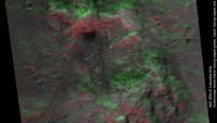
Founder Group: Chairman Posts: 14432 Joined: 8-February 04 Member No.: 1 |
Green slope good, red slope bad - very rough and ready, but it gives some sort of idea
 Doug
Attached thumbnail(s)
|
|
|
|
|
|
|
Mar 15 2006, 11:03 PM
Post
#10
|
|
 Dublin Correspondent Group: Admin Posts: 1799 Joined: 28-March 05 From: Celbridge, Ireland Member No.: 220 |
QUOTE (djellison @ Mar 15 2006, 10:43 PM) Green slope good, red slope bad - very rough and ready, but it gives some sort of idea Do you have that DEM? |
|
|
|
|
Mar 15 2006, 11:24 PM
Post
#11
|
|
|
Senior Member Group: Members Posts: 1229 Joined: 24-December 05 From: The blue one in between the yellow and red ones. Member No.: 618 |
QUOTE (djellison @ Mar 15 2006, 12:43 PM) Green slope good, red slope bad - very rough and ready, but it gives some sort of idea Doug Amazing. How was this produced? But it makes it look like we should be running southeast from HP, not northeast. Why am I confused?  Is the dark green to the SE way up near the summit? Is the dark green to the SE way up near the summit?
-------------------- My Grandpa goes to Mars every day and all I get are these lousy T-shirts!
|
|
|
|
|
Mar 16 2006, 09:43 AM
Post
#12
|
|
|
Founder Group: Chairman Posts: 14432 Joined: 8-February 04 Member No.: 1 |
We are going SE generally. Any one day's drive may not be in the exact direction of the over all goal - but it may be the best route that offers progress in the route required.
That was made using an elevation map derived from a DEM (which Helvick should have shortly ) and then in a 3D animation package - I simply put a green light source to the north, and a red one to the south - so the related slopes were illuminated appropriately. Doug |
|
|
|
|
Mar 16 2006, 01:50 PM
Post
#13
|
|
 Member Group: Members Posts: 267 Joined: 5-February 06 Member No.: 675 |
QUOTE (djellison @ Mar 16 2006, 04:43 AM) That was made using an elevation map derived from a DEM (which Helvick should have shortly ) and then in a 3D animation package - I simply put a green light source to the north, and a red one to the south - so the related slopes were illuminated appropriately. Thanks for a wonderfully helpful quick and dirty solution Doug My only concern is that it might miss some of the forenoon and afternoon illumination. Could you consider another try adding other greenish lights at northeast and southeast; perhaps blue-green at one corner and yellowish green at the other. If you need precision, and your spherical astronomy is fresher than mine  , you could compute the illuminaton angles for winter solstice around 0900 and 1500 Local Apparent Time. , you could compute the illuminaton angles for winter solstice around 0900 and 1500 Local Apparent Time.OOPS -- I meant northeast and northwest This post has been edited by Steve: Mar 16 2006, 04:10 PM |
|
|
|
|
Mar 16 2006, 07:56 PM
Post
#14
|
|
|
Dublin Correspondent Group: Admin Posts: 1799 Joined: 28-March 05 From: Celbridge, Ireland Member No.: 220 |
QUOTE (Steve @ Mar 16 2006, 01:50 PM) If you need precision, and your spherical astronomy is fresher than mine , you could compute the illuminaton angles for winter solstice around 0900 and 1500 Local Apparent Time.I intend to do something like that but it's going to be later in the weekend - real life work has cought up with me big time and I have some deadlines to meet. My plan is to integrate the daily insolation in hourly slices. The current model that I have takes about 100 seconds to do a full martian year on a Sol by sol basis _for_ a single position using a 20 minute time slice so I should be able to generate a 1024x1024 grid in about 30 minutes for a single sol. I think. I can cache a bunch of intermediate calculations for this though so I might be able to get an order of magnitude maybe even 2 of a speed boost once I look at it properly. |
|
|
|
|
Mar 16 2006, 08:41 PM
Post
#15
|
||
|
Senior Member Group: Members Posts: 2819 Joined: 22-April 05 From: Ridderkerk, Netherlands Member No.: 353 |
A panoramic view on Sol 781.
Taken with the L0 navcam. jvandriel
Attached thumbnail(s)
|
|
|
|
|
|
|

|
Lo-Fi Version | Time is now: 24th April 2024 - 08:49 PM |
|
RULES AND GUIDELINES Please read the Forum Rules and Guidelines before posting. IMAGE COPYRIGHT |
OPINIONS AND MODERATION Opinions expressed on UnmannedSpaceflight.com are those of the individual posters and do not necessarily reflect the opinions of UnmannedSpaceflight.com or The Planetary Society. The all-volunteer UnmannedSpaceflight.com moderation team is wholly independent of The Planetary Society. The Planetary Society has no influence over decisions made by the UnmannedSpaceflight.com moderators. |
SUPPORT THE FORUM Unmannedspaceflight.com is funded by the Planetary Society. Please consider supporting our work and many other projects by donating to the Society or becoming a member. |
|