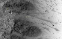
Mars Orbiter snaps boulder, Last month - boulder tumbles five hundred meters from location |

  |
Mars Orbiter snaps boulder, Last month - boulder tumbles five hundred meters from location |
 Aug 13 2014, 07:48 PM Aug 13 2014, 07:48 PM
Post
#1
|
|
 Junior Member  Group: Members Posts: 28 Joined: 1-July 13 From: United Kingdom, England Member No.: 6965 |
Hi there,
I read this on the NASA.gov site. Last month a tall boulder rolled five hundred meters, and tilted upright. There is no actual explanation as to why, seismic movement? Possibly the breeze of the wind.  I found the whole event interesting as the location is void and empty. Reminds me a little of the Rover and the peble. Boulder rolls down hill |
 |
 
|
|
Aug 14 2014, 01:32 PM
Post
#2
|
||
 Senior Member Group: Members Posts: 1089 Joined: 19-February 05 From: Close to Meudon Observatory in France Member No.: 172 |
QUOTE (RichforMars @ Aug 13 2014, 09:48 PM)  Hi there, I read this on the NASA.gov site. Last month a tall boulder rolled five hundred meters, and tilted upright. There is no actual explanation as to why, seismic movement? Possibly the breeze of the wind. I found the whole event interesting as the location is void and empty. Reminds me a little of the Rover and the peble.Thanks a lot RichforMars for your info. Apparently this big bouder made some vibrations that dislodged some smaller rocks too ! But with tracks less visible...
|
|
|
|
|
|
|
Aug 14 2014, 02:43 PM
Post
#3
|
|
|
Junior Member Group: Members Posts: 28 Joined: 1-July 13 From: United Kingdom, England Member No.: 6965 |
Interesting find, who realised that?
There is no actual Mars quake mission. So it remains a mystery for now. |
|
|
|
|
Aug 14 2014, 05:46 PM
Post
#4
|
|
|
Senior Member Group: Members Posts: 2106 Joined: 13-February 10 From: Ontario Member No.: 5221 |
There will be soon, Rich: http://insight.jpl.nasa.gov/home.cfm
It's the next one to launch! |
|
|
|
|
Aug 17 2014, 07:29 AM
Post
#5
|
|
 Member Group: Members Posts: 238 Joined: 15-January 13 Member No.: 6842 |
Are there images of this area prior to the rolling event?
-------------------- Curiosity rover panoramas: http://www.facebook.com/CuriosityRoverPanoramas
My Photosynth panoramas: http://photosynth.net/userprofilepage.aspx...;content=Synths |
|
|
|
|
Aug 17 2014, 07:54 AM
Post
#6
|
|
|
Merciless Robot Group: Admin Posts: 8785 Joined: 8-December 05 From: Los Angeles Member No.: 602 |
Might also be interesting to search for a nearby recent impact; that might've been what jarred it loose.
In fact, such a find would be incredibly informative since it could tell us a lot about subsurface properties that relate to conduction of motion. The energy from an impact could be calculated reasonably well as a function of crater diameter, so that would be a terrific 'calibrated' stimulus. -------------------- A few will take this knowledge and use this power of a dream realized as a force for change, an impetus for further discovery to make less ancient dreams real.
|
|
|
|
|
Aug 26 2014, 12:46 PM
Post
#7
|
|
|
Junior Member Group: Members Posts: 31 Joined: 3-August 14 From: Germany Member No.: 7229 |
QUOTE (RichforMars @ Aug 13 2014, 09:48 PM) I found the whole event interesting... Sorry for this note, but boulders that moved downhill with tracks have been seen since the first very high resolution images of the moon. So I personally don't get why this image (surely a great HiRISE image, don't get me wrong) should get more attention than others. -------------------- space scout
|
|
|
|
|
Aug 26 2014, 01:43 PM
Post
#8
|
|
|
Solar System Cartographer Group: Members Posts: 10229 Joined: 5-April 05 From: Canada Member No.: 227 |
It's not getting more attention, it's just getting its turn in the limelight. Otherwise, I guess there is the 'monolith' appearance of the boulder with its shadow to draw a bit of extra attention. The thing is, if you want the privilege of frequent news releases (as we generally do) you have to accept quite a lot of repetition - another fresh crater, another skylight, etc. Keep 'em coming, I say.
Phil -------------------- ... because the Solar System ain't gonna map itself.
Also to be found posting similar content on https://mastodon.social/@PhilStooke Maps for download (free PDF: https://upload.wikimedia.org/wikipedia/comm...Cartography.pdf NOTE: everything created by me which I post on UMSF is considered to be in the public domain (NOT CC, public domain) |
|
|
|
|
Aug 26 2014, 02:44 PM
Post
#9
|
|
|
Junior Member Group: Members Posts: 31 Joined: 3-August 14 From: Germany Member No.: 7229 |
Okay, I got the point. Perhaps I would have liked a more science-driven release. For example, I would have liked to learn about the science target of this image (I know many HiRISE images have one)
Cheers -------------------- space scout
|
|
|
|
|
Aug 26 2014, 02:56 PM
Post
#10
|
|
|
Founder Group: Chairman Posts: 14434 Joined: 8-February 04 Member No.: 1 |
If you follow the links you'll get to the HiRISE team page for the observation
http://hirise.lpl.arizona.edu/ESP_037190_1765 Where it says This image was targeted to cover part of a small chaos terrain, where there are lots of steep slopes. |
|
|
|
|
Aug 27 2014, 11:00 AM
Post
#11
|
|
|
Junior Member Group: Members Posts: 31 Joined: 3-August 14 From: Germany Member No.: 7229 |
Thank you for the link!
-------------------- space scout
|
|
|
|
|

|
Lo-Fi Version | Time is now: 27th September 2024 - 08:10 AM |
|
RULES AND GUIDELINES Please read the Forum Rules and Guidelines before posting. IMAGE COPYRIGHT |
OPINIONS AND MODERATION Opinions expressed on UnmannedSpaceflight.com are those of the individual posters and do not necessarily reflect the opinions of UnmannedSpaceflight.com or The Planetary Society. The all-volunteer UnmannedSpaceflight.com moderation team is wholly independent of The Planetary Society. The Planetary Society has no influence over decisions made by the UnmannedSpaceflight.com moderators. |
SUPPORT THE FORUM Unmannedspaceflight.com is funded by the Planetary Society. Please consider supporting our work and many other projects by donating to the Society or becoming a member. |
|