Dawn approaches Ceres, From opnav images to first orbit |

  |
Dawn approaches Ceres, From opnav images to first orbit |
 Mar 18 2015, 08:25 AM Mar 18 2015, 08:25 AM
Post
#691
|
|
|
Member  Group: Members Posts: 107 Joined: 1-August 14 Member No.: 7227 |
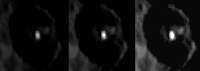
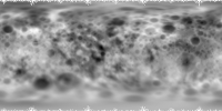
Some images grouped and annotated:
 My processing of the bright-spot area of the DEM: http://lc84.altervista.org/vba4.stl It's just a quick-and-dirt 3d model, a bit more (just a bit) than a point-cloud; I'm working to get a surface instead, but what's very interesting is the altitude of the center of the crater: although I can't know the actual values of altitudes corresponding to grey levels, the relative altitudes are correct:  |
 |
 
|
|
Mar 18 2015, 08:52 AM
Post
#692
|
|
 Senior Member Group: Members Posts: 1084 Joined: 19-February 05 From: Close to Meudon Observatory in France Member No.: 172 |
QUOTE (mcgyver @ Mar 18 2015, 09:25 AM)  Some images grouped and annotated: My processing of the bright-spot area of the DEM: It's just a quick-and-dirt 3d model, a bit more (just a bit) than a point-cloud; I'm working to get a surface instead, but what's very interesting is the altitude of the center of the crater: although I can't know the actual values of altitudes corresponding to grey levels, the relative altitudes are correct What an IMPRESSIVE work mcgyver : thanks a lot for sharing this with us ! 
|
|
|
|
|
Mar 18 2015, 07:41 PM
Post
#693
|
|||
|
Junior Member Group: Members Posts: 48 Joined: 20-December 14 Member No.: 7370 |
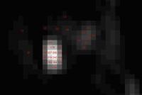
QUOTE (mcgyver @ Mar 18 2015, 12:25 AM) My processing of the bright-spot area of the DEM: http://lc84.altervista.org/vba4.stl It's just a quick-and-dirt 3d model, a bit more (just a bit) than a point-cloud; I'm working to get a surface instead, but what's very interesting is the altitude of the center of the crater: although I can't know the actual values of altitudes corresponding to grey levels, the relative altitudes are correct: Great processing, but as others have mentioned, I think the saturated pixels in the crater obfuscate any real depth cues for the DEM algorithms. I think the the picture with the most value is the one in the rotation movie right before it goes out of view, that has the central spot unsaturated.
From that picture it could be consistent with a floor with reflective ejecta spread around (the at 5-8% of the brightest pixel value). The little white spot peak is only 25% of the brightest pixel value so it's either likely a less albedo, or more likely - much smaller (3 adjacent 1/4 pixels). For the heck of it I tested the pixels in this image to try and get a better idea of what might be going on.
% conversions relative to the brightest 242 pixel are here: 12 5% 20 8% 28 12% 44 18% 53 22% 60 25% 92 38% 100 41% 124 51% 132 55% 144 60% 163 67% 179 74% 194 80% 219 90% 227 94% 235 97% 242 100% |
||
|
|
|
||
|
Mar 18 2015, 11:18 PM
Post
#694
|
|||
|
Junior Member Group: Members Posts: 64 Joined: 17-December 12 From: Portugal Member No.: 6792 |
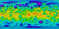
Based on the maps posted previously, here's color coded topography + hill shading:
And here's topography + visual surface features:
Very interesting surface! -------------------- www.astrosurf.com/nunes
|
||
|
|
|
||
|
Mar 19 2015, 10:28 AM
Post
#695
|
|
|
Member Group: Members Posts: 107 Joined: 1-August 14 Member No.: 7227 |
Just found this interesting Ceres images resources:
http://dawndata.igpp.ucla.edu/tw.jsp?secti...a/CeresApproach |
|
|
|
|
Mar 19 2015, 12:31 PM
Post
#696
|
|
 Member Group: Members Posts: 495 Joined: 12-February 12 Member No.: 6336 |
QUOTE (Ken2 @ Mar 18 2015, 08:41 PM) From that picture it could be consistent with a floor with reflective ejecta spread around (the at 5-8% of the brightest pixel value). The little white spot peak is only 25% of the brightest pixel value so it's either likely a less albedo, or more likely - much smaller (3 adjacent 1/4 pixels). Oh yes it was a good attempt by mcgyver there. But as have been pointed out, the wiremap is based on data we can not place much confidence in. The image you provided Ken2 is perhaps the best good example we have where the bright spot is seen at the smallest size. Yet even there it show signs of being saturated with light bleeding into adjacent pixels. One of the scientists involved with the Dawn mission mentioned a possible albedo of 0,4 for this feature. At the time I accepted the number as realistic - since we then thought of ice that had been exposed by the impact and since then dusted over somewhat. But if this feature instead is fresh, and is associated with the outgassing perhaps even a geyser like feature, it would be smaller still and the albedo might be as high as 0,8 or even 0,9! So in short, the smaller this bright area turn out to be, the more interesting it will be. =) |
|
|
|
|
Mar 19 2015, 01:33 PM
Post
#697
|
|
 Member Group: Members Posts: 656 Joined: 20-April 05 From: League City, Texas Member No.: 285 |
QUOTE (4throck @ Mar 18 2015, 06:18 PM) Based on the maps posted previously, here's color coded topography + hill shading: ... It would be informative to see something like this referenced to the geoid, if one were available. |
|
|
|
|
Mar 19 2015, 05:57 PM
Post
#698
|
|
 Member Group: Members Posts: 714 Joined: 3-January 08 Member No.: 3995 |
Has anyone estimated the minimum albedo of the most prominent bright spot?
|
|
|
|
|
Mar 19 2015, 07:00 PM
Post
#699
|
|||
|
Member Group: Members Posts: 656 Joined: 20-April 05 From: League City, Texas Member No.: 285 |
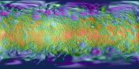
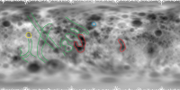
QUOTE (mcgyver @ Mar 18 2015, 03:25 AM) Some images grouped and annotated: Here's my own take on a height map. I estimated an ellipsoid per the DEM, then took height as the difference between the DEM and the fitted ellipsoid (the overlaid ellipsoid fits rather well overall), and the gray levels linearly span 15.4 kilometers from lowest (black) to highest (white) elevation; the scattered white pixels near the poles are missing data. Originally this was 1 pixel per degree, but resampled to 4 pixels per degree. I have the 0-longitude at the center, mainly for my own convenience.
There are some interesting structures apparent in the height map, aside from the craters. This perspective lets us focus on the region near 180 degrees longitude (centered). Note the two prominent equatorial lows outlined in red, particularly the one near 160 degrees (left of center) -- this is the opposite of evidence for viscous relaxation. In that same region, outline in green, are a region of valleys and ridges which appear more tectonically derived rather than due to impacts. Everyone's favorite white spot is circled in yellow, and an anomalous high spot is circled in blue.
I would guess that the ejecta from the sand dollar feature drapes a tectonically similar region to that on the opposite side of Ceres, only hinted at on the existing surface. |
||
|
|
|
||
|
Mar 19 2015, 09:24 PM
Post
#700
|
||
|
Member Group: Members Posts: 656 Joined: 20-April 05 From: League City, Texas Member No.: 285 |
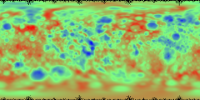
And here's the same height map, with the height mapped to colors from lowest in blue, middle in green, to highest in red. I'm not sure this adds anything dramatically more informative, but it is certainly pretty

|
|
|
|
|
|
|
Mar 19 2015, 09:31 PM
Post
#701
|
|
|
Member Group: Members Posts: 714 Joined: 3-January 08 Member No.: 3995 |
"At dawn on Ceres, feature number 5 appears bright. By dusk, it seems to fade"
From Nature article: QUOTE (belleraphon1 @ Mar 17 2015, 04:41 PM) Bright spots on Ceres could be active ice http://www.nature.com/news/bright-spots-on...=TWT_NatureNews When would the feature have been visible at dawn? In the released images so far, only the evening terminator has been visible. Did they take more images after March 1 (OpNav 5)? |
|
|
|
|
Mar 19 2015, 10:00 PM
Post
#702
|
|
|
Senior Member Group: Members Posts: 3516 Joined: 4-November 05 From: North Wales Member No.: 542 |
QUOTE (Gladstoner @ Mar 19 2015, 09:31 PM) "At dawn on Ceres, feature number 5 appears bright. By dusk, it seems to fade" It's an odd statement in any case. You would expect any place to be colder at dawn than at dusk, so why would it be more active at dawn? The only explanation I can think of is that there is overnight frost there that burns off in the morning. Curiouser and curiouser. |
|
|
|
|
Mar 19 2015, 10:29 PM
Post
#703
|
||
|
Senior Member Group: Members Posts: 2346 Joined: 7-December 12 Member No.: 6780 |
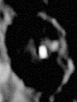
After magnifying and a nonlinear stretch, I'm using this crop of image 5 of pia18920 more as an inspiration than as a remotely reliable interpretation to get an idea for a possible explanation of the dimming of the bright spot near dusk:
If I take the dark frame background as shadowed, there may be a peak immediately left of the bright spot, which either casts a shadow onto the bright spot near dusk, or hides some of the bright feature. Such an approach may be able to avoid the assumption of diurnal changes of the surface. That's just an idea for an alternative approach, but far from any evidence with this one image. |
|
|
|
|
|
|
Mar 20 2015, 12:48 AM
Post
#704
|
|
 Senior Member Group: Members Posts: 3419 Joined: 9-February 04 From: Minneapolis, MN, USA Member No.: 15 |
I'll also point out that variable reflection may indicate an asymmetry in the albedo of an ice-enriched central peak.
As a gedankenexperiment, let's imagine that the crater within which the Ceres White Spot ("feature number five") resides has a pronounced central peak. Even without any cryovolcanism, the central peak rebound will pull up the deepest levels of the impact target -- so let's say that, in the case of this crater, what was pushed up as a central peak shows where the impact punched through to a water ice layer, and as such is highly enriched in water ice as compared to the crater's rim and floor. Now, as time goes along, the crater rim and floor will darken with ejecta from nearby impacts, and perhaps weren't as enriched in ice as the central peak. The central peak, however, as we have seen in lunar central peaks, has a tendency to cleave down as impacts happen onto it, leaving huge blocks of itself at the base of the peak. Over time, the central peak will darken such that it's still brighter than the floor or walls of the crater, but not tremendously so. Then a decent-sized small impactor hits the central peak right near its top. All sides of the peak shed off accumulated dark covering debris, and if it's got a really high ice enrichment, it might leave nice, flat cleaved faces. In other words, a mountain of ice with steep sides can get its darkening cover blasted off repeatedly over time, and each time it happens, the sides of the peak become highly reflective. But they don't necessarily reflect in all directions the same, with some slopes pointing more directly at a given observer than at another observer looking from a different direction. And, at least for a while after such an impact, the resulting sudden mass wasting that occurs (think avalanche or landslide) also piles layers of bright water ice at the foot of the peak. So, at dawn, the sunlight strikes a (relatively) reflective ice surface and reflects the solar image brightly. As the day progresses, and the feature moves from left to right (as we've been looking at it), the reflection shifts from one bright facet of the peak to the next. But as we approach the right terminator, the light dims because the side of the peak we're looking at is rougher and darker, or just not "aimed" as directly back to the observation point. This thought experiment derives a possible configuration of a crater that fits with what we know about crater formation, what (little) we know about the composition of Ceres, and what kinds of effects could cause variable brightness in reflections from potentially icy surfaces. I surely don't insist this is the correct theory, but I think it fits all the facts we have at present. Personally, I'd prefer to see a variably-deposited snowfield surrounding a geysering central peak, but since that's what others are looking at, I figured I'd see if there are other ways to explain what we're seeing, and I think I found one. It's just not the one I want to see... -the other Doug -------------------- The trouble ain't that there is too many fools, but that the lightning ain't distributed right. -Mark Twain
|
|
|
|
|
Mar 20 2015, 04:32 AM
Post
#705
|
|
|
Merciless Robot Group: Admin Posts: 8783 Joined: 8-December 05 From: Los Angeles Member No.: 602 |
Certainly some fascinating speculation on the thread so far. Rather unusual to have a mystery like this persist for this long after a first encounter, I think, but that's undoubtedly a consequence of Dawn's approach & orbital capture trajectory requirements.
The only conclusion I feel safe to make is very generic: Whatever it is, it's young, and I mean like thousands of years old maybe; I'd guess younger than that. My rationale is that there seems to be only one of these regions on Ceres, and it's tiny. (Okay, two close together but REAL close, so almost certainly associated.) There are other geological provinces of sorts, but all of far greater extent. In turn, to me this argues for an exogenic origin since an endogenic process would likely not be confined to such a small area of this body. In fact, and please correct me if I'm wrong, on every object we've examined with current active surface processes (volcanic or not) said processes are distributed across broad regions of the body. Iapetus' albedo process is global, Enceladus' geysers are regional but across a proportionally large area of the moon's surface, Titan's seas are polar. Therefore, I'm putting my money on a VERY fresh pair of impact craters that have exposed underlying ice. That may well be sublimating when exposed to direct sunlight just like a comet's ices do, but that's the extent of activity. Pure luck that this happened before Dawn arrived is all. If this model is correct, Ceres must periodically sport relatively dazzling bright spots until they are covered by either Sun-induced darkening of organics or dust from other impacts. -------------------- A few will take this knowledge and use this power of a dream realized as a force for change, an impetus for further discovery to make less ancient dreams real.
|
|
|
|
|

|
Lo-Fi Version | Time is now: 27th April 2024 - 03:27 AM |
|
RULES AND GUIDELINES Please read the Forum Rules and Guidelines before posting. IMAGE COPYRIGHT |
OPINIONS AND MODERATION Opinions expressed on UnmannedSpaceflight.com are those of the individual posters and do not necessarily reflect the opinions of UnmannedSpaceflight.com or The Planetary Society. The all-volunteer UnmannedSpaceflight.com moderation team is wholly independent of The Planetary Society. The Planetary Society has no influence over decisions made by the UnmannedSpaceflight.com moderators. |
SUPPORT THE FORUM Unmannedspaceflight.com is funded by the Planetary Society. Please consider supporting our work and many other projects by donating to the Society or becoming a member. |
|