From Cambridge Bay to the "parking lot" |

  |
From Cambridge Bay to the "parking lot" |
 Sep 2 2010, 07:49 PM Sep 2 2010, 07:49 PM
Post
#16
|
|
|
Newbie  Group: Members Posts: 10 Joined: 23-November 08 Member No.: 4493 |
From the last Planetary Society Update:
"...Were six miles away [9.65 kilometers] and we can see the thing, and its made everybody that much more excited and eager to make it there, said Maxwell. http://www.planetary.org/news/2010/0831_Ma...ate_Spirit.html |
 |
 
|
|
Sep 2 2010, 07:50 PM
Post
#17
|
|
|
Senior Member Group: Members Posts: 2920 Joined: 14-February 06 From: Very close to the Pyrénées Mountains (France) Member No.: 682 |
QUOTE (Tesheiner @ Sep 2 2010, 07:18 PM)  If we take a straight line to Santa Maria and another one to Cape York, yes. Obviously, the odometry will be much more but that's another story. ...and we've crossed the 10 km ODOMETRY from Victoria on last drive... -------------------- |
|
|
|
|
Sep 2 2010, 09:13 PM
Post
#18
|
|
 Senior Member Group: Members Posts: 1887 Joined: 20-November 04 From: Iowa Member No.: 110 |
Half way there, that means we should arrive in (ducks)
 July 2012, a month before MSL reaches Mars. Go Oppy Go |
|
|
|
|
Sep 2 2010, 10:19 PM
Post
#19
|
|
|
Junior Member Group: Members Posts: 71 Joined: 19-January 10 From: Grimsby, N.E. Lincs, UK Member No.: 5179 |
QUOTE (charborob @ Sep 2 2010, 08:23 PM) Seriously, the official Opportunity traverse map for sol 2286 (http://marsrovers.jpl.nasa.gov/mission/tm-...ty-sol2286.html) has a progress bar showing that 8km has been covered out of 19km, meaning there was 11km to go. On sol 2341, 1,24 km more had been added to the total, so, yes, I guess we're under 10 km away (depending on the twists and turns to come). Loving the stat fest that is going on on this thread at the minute so I thought I would add my stat of the day! On the assumption that Charborob's figures are correct (and why shouldn't they be) then we are only 260m from the halfway point on the projected travel path between Victoria and Endurance. Go Oppy! Neil |
|
|
|
|
Sep 3 2010, 05:38 AM
Post
#20
|
|
 Senior Member Group: Members Posts: 2228 Joined: 1-December 04 From: Marble Falls, Texas, USA Member No.: 116 |
In keeping with the "teach a man to fish" theme we saw last month, we should point out that Google Earth/Mars has a very useful ruler tool that, in conjunction with Eduardo's excellent KML route map, can be used to easily and accurately measure all sorts of distances along Opportunity's route, and elsewhere. Using it, I measured 9.65 km from the sol 2348 location to near Cape York following the proposed route line; the same distance quoted in the Planetary Society Update.

-------------------- ...Tom
I'm not a Space Fan, I'm a Space Exploration Enthusiast. |
|
|
|
|
Sep 3 2010, 05:56 AM
Post
#21
|
|
 The Poet Dude Group: Moderator Posts: 5551 Joined: 15-March 04 From: Kendal, Cumbria, UK Member No.: 60 |
Yep, and that's exactly the tool I used to reach my "slightly less than 10km" figure, CR, as my blog says...
Hadn't actually read the latest MER Update all the way through until earlier today. That would have saved me some time, I guess!  -------------------- |
|
|
|
|
Sep 3 2010, 06:32 AM
Post
#22
|
|
 Senior Member Group: Members Posts: 2173 Joined: 28-December 04 From: Florida, USA Member No.: 132 |
Working on a new record here for number of posts between Opportunity Route Maps.
|
|
|
|
|
Sep 3 2010, 06:38 AM
Post
#23
|
|
|
The Poet Dude Group: Moderator Posts: 5551 Joined: 15-March 04 From: Kendal, Cumbria, UK Member No.: 60 |
...and thanks for contributing to the record attempt

-------------------- |
|
|
|
|
Sep 3 2010, 07:27 AM
Post
#24
|
||
|
Senior Member Group: Moderator Posts: 4279 Joined: 19-April 05 From: .br at .es Member No.: 253 |
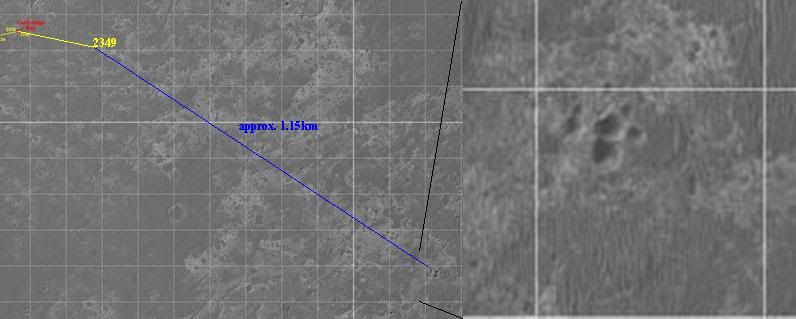
Here's the latest navcam mosaic, taken during sol 2349 after a 80+ meters drive.
We can see right ahead (10 meters?) traces of the rocky pavement which will be the rover's path for the next 1.5km. It's time to say "good bye" to the sea of dunes. |
|
|
|
|
|
|
Sep 3 2010, 10:27 AM
Post
#25
|
||
|
The Poet Dude Group: Moderator Posts: 5551 Joined: 15-March 04 From: Kendal, Cumbria, UK Member No.: 60 |
I thought it might be interesting to see what the ground ahead is actually like for our gal, so here's a pic showing HiRISE views - all to the same scale - of (on the left) the terrain we've been driving across recently and, on the right, 1) the terrain we'll be driving across once we get off "the Pavement", and 2) the terrain we'll be crossing once in "The Parking Lot". Note: Of course, these are just quick look samples, there'll be smoother and rougher areas, and this is just for fun, but I still thought it was quite interesting to see them side by side...
-------------------- |
|
|
|
|
|
|
Sep 3 2010, 03:50 PM
Post
#26
|
|
 Junior Member Group: Members Posts: 39 Joined: 19-August 09 From: Dallas Member No.: 4905 |
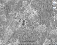
Possible multiple (6-7?) crater approx. 1 km ESE from Opportunity current position.
|
|
|
|
|
Sep 3 2010, 04:20 PM
Post
#27
|
||
|
Senior Member Group: Moderator Posts: 4279 Joined: 19-April 05 From: .br at .es Member No.: 253 |
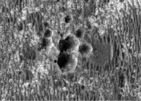
Or eight! Here's a better image taken from GE.
And what a coincidence. I saw the group some time ago and I'm actually using it as a "control point" (named "Triplet") for my tool which automatically generates the KML version of the route map. These "control points" are used to interpolate/extrapolate the lat/long coordinates of the actual route points. |
|
|
|
|
|
|
Sep 3 2010, 04:34 PM
Post
#28
|
|
|
The Poet Dude Group: Moderator Posts: 5551 Joined: 15-March 04 From: Kendal, Cumbria, UK Member No.: 60 |
(leans over from the back seat)
Oh wow! Can we go there? Can we? can we? Can we? 
-------------------- |
|
|
|
|
Sep 3 2010, 04:40 PM
Post
#29
|
|
|
Junior Member Group: Members Posts: 39 Joined: 19-August 09 From: Dallas Member No.: 4905 |
QUOTE (Tesheiner @ Sep 3 2010, 10:20 AM) Or eight! Reminds me of Morasko (Poland) set of 7 craters: wikipedia article 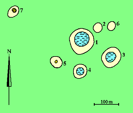 |
|
|
|
|
Sep 3 2010, 05:41 PM
Post
#30
|
||
|
The Poet Dude Group: Moderator Posts: 5551 Joined: 15-March 04 From: Kendal, Cumbria, UK Member No.: 60 |
... and just to give a sense of scale, here's "Oppy" (scale correct, it's cloned from the same HiRISE image) next to the craters...
-------------------- |
|
|
|
|
|
|

|
Lo-Fi Version | Time is now: 12th May 2024 - 11:53 AM |
|
RULES AND GUIDELINES Please read the Forum Rules and Guidelines before posting. IMAGE COPYRIGHT |
OPINIONS AND MODERATION Opinions expressed on UnmannedSpaceflight.com are those of the individual posters and do not necessarily reflect the opinions of UnmannedSpaceflight.com or The Planetary Society. The all-volunteer UnmannedSpaceflight.com moderation team is wholly independent of The Planetary Society. The Planetary Society has no influence over decisions made by the UnmannedSpaceflight.com moderators. |
SUPPORT THE FORUM Unmannedspaceflight.com is funded by the Planetary Society. Please consider supporting our work and many other projects by donating to the Society or becoming a member. |
|