Dawn approaches Vesta, Approach phase, 3 May to 16 July 2011 |

  |
Dawn approaches Vesta, Approach phase, 3 May to 16 July 2011 |
 Jul 8 2011, 03:23 AM Jul 8 2011, 03:23 AM
Post
#346
|
|
 Senior Member  Group: Moderator Posts: 2785 Joined: 10-November 06 From: Pasadena, CA Member No.: 1345 |
QUOTE Also, I am quite intrigued by the apparent ridge extending from the mountain. Any ideas (guesses) how such a feature could form, assuming it isn't an artifact due to the low resolution? I was wondering if that was a debris flow and apron. The next higher resolution image should be interesting. -------------------- Some higher resolution images available at my photostream: http://www.flickr.com/photos/31678681@N07/
|
 |
 
|
|
Jul 8 2011, 05:25 AM
Post
#347
|
|
 Senior Member Group: Members Posts: 1729 Joined: 3-August 06 From: 43° 35' 53" N 1° 26' 35" E Member No.: 1004 |
the spacecraft, meanwhile, had some thruster problem: Dawn Team Members Check out Spacecraft
|
|
|
|
|
Jul 8 2011, 05:38 AM
Post
#348
|
|
 Senior Member Group: Moderator Posts: 3233 Joined: 11-February 04 From: Tucson, AZ Member No.: 23 |
QUOTE (Juramike @ Jul 7 2011, 08:23 PM)  I was wondering if that was a debris flow and apron. That certainly what it looks like to me. -------------------- &@^^!% Jim! I'm a geologist, not a physicist!
The Gish Bar Times - A Blog all about Jupiter's Moon Io |
|
|
|
|
Jul 8 2011, 05:56 AM
Post
#349
|
||
 Senior Member Group: Members Posts: 2492 Joined: 15-January 05 From: center Italy Member No.: 150 |
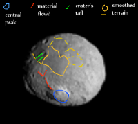
QUOTE (Paolo @ Jul 8 2011, 05:25 AM) the spacecraft, meanwhile, had some thruster problem: Dawn Team Members Check out Spacecraft In the report, they say "One set of images for navigation purposes was not obtained on June 28 because the spacecraft was in safe-communications mode...". Perhaps, this explain the longer-than-expected waiting for new images, as complained in previous days...Speaking of surface features, in addition to smoothed terrain and ridge/debris, did someone noticed the apparent tails in one crater, highlighted in green in the following image? If isn't an artifact, how to explain it?
Attached thumbnail(s)
-------------------- I always think before posting! - Marco -
|
|
|
|
|
|
|
Jul 8 2011, 12:42 PM
Post
#350
|
|
|
Junior Member Group: Members Posts: 61 Joined: 20-March 10 From: Western Australia Member No.: 5275 |
Got it, thanks. Err yeah, one helluva mountain (and crater!)
|
|
|
|
|
Jul 8 2011, 12:54 PM
Post
#351
|
|
|
Solar System Cartographer Group: Members Posts: 10153 Joined: 5-April 05 From: Canada Member No.: 227 |
I would vote for the linear feature on the mountain being a fault rather than a mass wasting feature.
Phil -------------------- ... because the Solar System ain't gonna map itself.
Also to be found posting similar content on https://mastodon.social/@PhilStooke Maps for download (free PD: https://upload.wikimedia.org/wikipedia/comm...Cartography.pdf NOTE: everything created by me which I post on UMSF is considered to be in the public domain (NOT CC, public domain) |
|
|
|
|
Jul 8 2011, 11:42 PM
Post
#352
|
|
|
Member Group: Members Posts: 813 Joined: 29-December 05 From: NE Oh, USA Member No.: 627 |
Latest image is my desktop background. Keep staring at it. This is going to be awesome. What a peak! |
|
|
|
|
Jul 9 2011, 12:29 AM
Post
#353
|
|
 Member Group: Members Posts: 714 Joined: 3-January 08 Member No.: 3995 |
Is there any chance that the mountain could be the remains of a former satellite that "soft landed" in the distant past? At what point (re: tidal forces, impact velocity, size difference) does such a "meet-up" go from being a contact binary to an impact?
|
|
|
|
|
Jul 9 2011, 12:46 AM
Post
#354
|
|
|
Senior Member Group: Members Posts: 2082 Joined: 13-February 10 From: Ontario Member No.: 5221 |
It would have to be a very long time ago indeed; these days the high relative velocities just smash them into smaller pieces, making accretion almost impossible. (see 596 Scheila for a recent example).
|
|
|
|
|
Jul 9 2011, 01:47 AM
Post
#355
|
|
 Senior Member Group: Admin Posts: 4763 Joined: 15-March 05 From: Glendale, AZ Member No.: 197 |
QUOTE (Gladstoner @ Jul 8 2011, 05:29 PM) Is there any chance that the mountain could be the remains of a former satellite that "soft landed" in the distant past? Based on the shape of Vesta and the sheer volume of Vesta-related debris throughout the solar it's quite clear that this is the result of a massive, high-energy impact. -------------------- If Occam had heard my theory, things would be very different now.
|
|
|
|
|
Jul 9 2011, 03:16 AM
Post
#356
|
|
|
Senior Member Group: Members Posts: 1582 Joined: 14-October 05 From: Vermont Member No.: 530 |
QUOTE (ElkGroveDan @ Jul 8 2011, 09:47 PM) sheer volume pun? |
|
|
|
|
Jul 9 2011, 04:20 AM
Post
#357
|
|
|
Senior Member Group: Moderator Posts: 2785 Joined: 10-November 06 From: Pasadena, CA Member No.: 1345 |
Genius.
-------------------- Some higher resolution images available at my photostream: http://www.flickr.com/photos/31678681@N07/
|
|
|
|
|
Jul 9 2011, 06:17 AM
Post
#358
|
|
|
Merciless Robot Group: Admin Posts: 8783 Joined: 8-December 05 From: Los Angeles Member No.: 602 |
Yes, it had impact, and did not crater.
-------------------- A few will take this knowledge and use this power of a dream realized as a force for change, an impetus for further discovery to make less ancient dreams real.
|
|
|
|
|
Jul 10 2011, 11:53 AM
Post
#359
|
|
 Member Group: Members Posts: 568 Joined: 20-April 05 From: Silesia Member No.: 299 |
No change in relative speed (last 24 hour), no spacecraft orientation on diagram.
http://neo.jpl.nasa.gov/orbits/fullview4.jpg Like two weeks ago. Should I be worried ? 
-------------------- Free software for planetary science (including Cassini Image Viewer).
http://members.tripod.com/petermasek/marinerall.html |
|
|
|
|
Jul 10 2011, 01:04 PM
Post
#360
|
|
|
Junior Member Group: Members Posts: 55 Joined: 6-March 10 From: Cincinnati, OH Member No.: 5246 |
QUOTE (Phil Stooke @ Jul 8 2011, 07:54 AM) I would vote for the linear feature on the mountain being a fault rather than a mass wasting feature. Phil I'm wondering if it could be an exhumed dike, given the assumed igneous nature of the crust. I also prefer a volcano-tectonic explaination over mass wasting. Time will tell. Tom |
|
|
|
|

|
Lo-Fi Version | Time is now: 27th April 2024 - 03:58 PM |
|
RULES AND GUIDELINES Please read the Forum Rules and Guidelines before posting. IMAGE COPYRIGHT |
OPINIONS AND MODERATION Opinions expressed on UnmannedSpaceflight.com are those of the individual posters and do not necessarily reflect the opinions of UnmannedSpaceflight.com or The Planetary Society. The all-volunteer UnmannedSpaceflight.com moderation team is wholly independent of The Planetary Society. The Planetary Society has no influence over decisions made by the UnmannedSpaceflight.com moderators. |
SUPPORT THE FORUM Unmannedspaceflight.com is funded by the Planetary Society. Please consider supporting our work and many other projects by donating to the Society or becoming a member. |
|