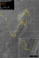
Opportunity Route Map |

  |
Opportunity Route Map |
 Oct 23 2012, 08:16 PM Oct 23 2012, 08:16 PM
Post
#3136
|
|
 Senior Member  Group: Members Posts: 4246 Joined: 17-January 05 Member No.: 152 |
I've been eager to see how the route develops since this update where they said
QUOTE The plan ahead is a drive around "the loop" that encompasses the terrain mapped by the orbital clay observations and survey the area with rover imagery. So it looks like this "drunken sailor" path is giving us clues about what the latest CRISM imagery shows.
|
 |
 
|
|
Oct 23 2012, 08:29 PM
Post
#3137
|
||
|
Senior Member Group: Moderator Posts: 4279 Joined: 19-April 05 From: .br at .es Member No.: 253 |
And now the "standard map products" for sol 3110.
 Route_Map_Sol3110.kmz ( 22.09K )
Number of downloads: 298
Route_Map_Sol3110.kmz ( 22.09K )
Number of downloads: 298 |
|
|
|
|
|
|
Oct 23 2012, 09:46 PM
Post
#3138
|
|
|
Senior Member Group: Members Posts: 2919 Joined: 14-February 06 From: Very close to the Pyrénées Mountains (France) Member No.: 682 |
QUOTE (fredk @ Oct 23 2012, 10:16 PM)  I've been eager to see how the route develops since this update where they saidSo it looks like this "drunken sailor" path is giving us clues about what the latest CRISM imagery shows. Pretty nice deduction! Anyway the shape of the tajectory is looking like a "?" -------------------- |
|
|
|
|
Oct 27 2012, 06:18 PM
Post
#3139
|
|
|
Senior Member Group: Moderator Posts: 4279 Joined: 19-April 05 From: .br at .es Member No.: 253 |
|
|
|
|
|
Oct 28 2012, 08:37 PM
Post
#3140
|
||
|
Senior Member Group: Moderator Posts: 4279 Joined: 19-April 05 From: .br at .es Member No.: 253 |
Sol 3114. The map at 1m/pix is becoming too cluttered around this area.

Route_Map_Sol3114.kmz ( 22.18K )
Number of downloads: 259 |
|
|
|
|
|
|
Oct 31 2012, 10:04 PM
Post
#3141
|
|
|
Senior Member Group: Moderator Posts: 4279 Joined: 19-April 05 From: .br at .es Member No.: 253 |
|
|
|
|
|
Nov 2 2012, 08:49 PM
Post
#3142
|
|
|
Senior Member Group: Moderator Posts: 4279 Joined: 19-April 05 From: .br at .es Member No.: 253 |
|
|
|
|
|
Nov 3 2012, 02:11 PM
Post
#3143
|
||
 The Poet Dude Group: Moderator Posts: 5551 Joined: 15-March 04 From: Kendal, Cumbria, UK Member No.: 60 |
Thanks Tesh! Only 7 downloads?!?!? Come on people! Don't forget Oppy!! She might not be able to take sexy self portraits but she's still roving...!
 Time for a reminder of where Oppy is in relation to those phyllosilicates she drove all the way to Cape York to hunt for in the first place...
-------------------- |
|
|
|
|
|
|
Nov 3 2012, 03:14 PM
Post
#3144
|
|
|
Senior Member Group: Members Posts: 4246 Joined: 17-January 05 Member No.: 152 |
That's for the kmz file. The jpeg map has 235 downloads and counting! We haven't forgotten the gal yet!
BTW, that CRISM map is old data - they have higher resolution data (which we haven't seen) that they're basing the current survey on. |
|
|
|
|
Nov 3 2012, 03:23 PM
Post
#3145
|
|
 Member Group: Members Posts: 221 Joined: 25-March 05 Member No.: 217 |
Hi Stu
I'm one of the (magnificent) seven and I'm surprised the figure is so low. Tesh has done a really great job over the years we won't forget any of the mars rovers partly thanks to all his work. Roy F |
|
|
|
|
Nov 3 2012, 03:42 PM
Post
#3146
|
|
|
Senior Member Group: Members Posts: 3516 Joined: 4-November 05 From: North Wales Member No.: 542 |
QUOTE (fredk @ Nov 3 2012, 03:14 PM) The jpeg map has 235 downloads and counting! BTW, that CRISM map is old data - they have higher resolution data (which we haven't seen) That's me in the happy crowd of 235 then. Regarding that improved CRISM map: Every time this comes up I have the same nagging thought that actually we have seen it and it's buried in a post somewhere in who-knows-which thread. Does anyone else think they remember this? If it's just me I'll assume I imagined it. |
|
|
|
|
Nov 3 2012, 05:27 PM
Post
#3147
|
|
|
Solar System Cartographer Group: Members Posts: 10149 Joined: 5-April 05 From: Canada Member No.: 227 |
This may be of interest though it doesn't directly map the clays:
http://www.kiss.caltech.edu/workshops/xter...arvidson_sc.pdf Phil -------------------- ... because the Solar System ain't gonna map itself.
Also to be found posting similar content on https://mastodon.social/@PhilStooke NOTE: everything created by me which I post on UMSF is considered to be in the public domain (NOT CC, public domain) |
|
|
|
|
Nov 3 2012, 05:49 PM
Post
#3148
|
|
 Senior Member Group: Members Posts: 2173 Joined: 28-December 04 From: Florida, USA Member No.: 132 |
QUOTE (fredk @ Nov 3 2012, 10:14 AM) That's for the kmz file. The jpeg map has 235 downloads... I follow the maps faithfully but never download the kmz file. What am I missing?
|
|
|
|
|
Nov 3 2012, 05:59 PM
Post
#3149
|
|
|
Senior Member Group: Members Posts: 2080 Joined: 13-February 10 From: Ontario Member No.: 5221 |
It's for Google Earth, which we don't all use.
|
|
|
|
|
Nov 3 2012, 06:06 PM
Post
#3150
|
|
|
The Poet Dude Group: Moderator Posts: 5551 Joined: 15-March 04 From: Kendal, Cumbria, UK Member No.: 60 |
QUOTE (fredk @ Nov 3 2012, 03:14 PM) BTW, that CRISM map is old data - they have higher resolution data (which we haven't seen) that they're basing the current survey on. Yep, I know it's old data, but as you say we haven't seen the new data yet; can only use what we've got And you did all see the I put at the end of my comment, right? It wasn't a criticism.  -------------------- |
|
|
|
|

|
Lo-Fi Version | Time is now: 23rd April 2024 - 08:30 AM |
|
RULES AND GUIDELINES Please read the Forum Rules and Guidelines before posting. IMAGE COPYRIGHT |
OPINIONS AND MODERATION Opinions expressed on UnmannedSpaceflight.com are those of the individual posters and do not necessarily reflect the opinions of UnmannedSpaceflight.com or The Planetary Society. The all-volunteer UnmannedSpaceflight.com moderation team is wholly independent of The Planetary Society. The Planetary Society has no influence over decisions made by the UnmannedSpaceflight.com moderators. |
SUPPORT THE FORUM Unmannedspaceflight.com is funded by the Planetary Society. Please consider supporting our work and many other projects by donating to the Society or becoming a member. |
|