Endeavour Drive - Drivability analysis |

  |
Endeavour Drive - Drivability analysis |
 Sep 22 2008, 05:48 PM Sep 22 2008, 05:48 PM
Post
#136
|
|
 Senior Member  Group: Moderator Posts: 2262 Joined: 9-February 04 From: Melbourne - Oz Member No.: 16 |
QUOTE (PaulM @ Sep 22 2008, 06:36 PM)  The fact that Oppy can see the rim of Endeavour crater from its present location shows that Endeavour is not really that far away. I can't remember this very well so I could be wrong, but I seem to remember doing some analysis that suggested that that was a feature on the far rim. So where we are going is even closer.  James -- Just trying to work out how to load jpeg-2000 images using a decent programming language with the aim of finding ways of classifying ripples automatically.
-------------------- |
 |
 
|
|
Sep 22 2008, 06:00 PM
Post
#137
|
|
 Member Group: Members Posts: 813 Joined: 8-February 04 From: Arabia Terra Member No.: 12 |
QUOTE (jamescanvin @ Sep 22 2008, 06:48 PM) -- Just trying to work out how to load jpeg-2000 images using a decent programming language with the aim of finding ways of classifying ripples automatically. Cool. Found some useful information on exporting them to other formats: http://orrery.us/node/61 |
|
|
|
|
Sep 22 2008, 06:35 PM
Post
#138
|
|
|
Senior Member Group: Members Posts: 1583 Joined: 14-October 05 From: Vermont Member No.: 530 |
Would HiRise photos taken when the sun is low in the sky help? Ideally you'd have shadows everywhere you want to avoid.
|
|
|
|
|
Sep 22 2008, 07:35 PM
Post
#139
|
||
|
Member Group: Members Posts: 111 Joined: 14-March 05 From: Vastitas Borealis Member No.: 193 |
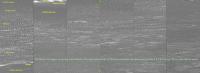
Remembering how the MER-B images had to be stretched vertically to highlight the subtleties in them, I was wondering if it would work to do the opposite, i.e. visually compress satellite images, to get a better grasp of the navigability of the terrain and those long parallel dunes. Fortunately the ripples are almost due N-S oriented, so it was easy to test my idea with the available HiRise jp2 images. I cut long N-S 'bands' from the general south-eastern side of Victoria (in PSP_001414_1780_RED), all the same size, the same distance from each other, 150 m wide, 3300 m long, 600 m apart. Then I shortened the bands to 10 % of their original lenght and made a side-by-side collage of them for navigability comparison. The leftmost image shows a similar-sized compressed band of Oppy's earlier path.
I have labeled some familiar places along the earlier route. The composition is radically diminished from its original size to fit here, but I hope you still can make some sense of it and that it's enjoyable to rover driver(s) and all us backseaters as well. Concurring with many previous posts, I think we can relatively safely assume that Oppy has already seen the worst of it concerning the dunes.
Attached thumbnail(s)
|
|
|
|
|
|
|
Sep 22 2008, 07:46 PM
Post
#140
|
|
|
Senior Member Group: Members Posts: 2922 Joined: 14-February 06 From: Very close to the Pyrénées Mountains (France) Member No.: 682 |
When you open UMSF after a 3 days break and see a new topic with over 130 replies, you know there's a big news around.
So, we're (again) looking for a 2 years exploration journey...NeverEndeavouring Story... You're right Paolo, there are fantastic minds in UMSF and we also have the best job in the world... -------------------- |
|
|
|
|
Sep 22 2008, 07:51 PM
Post
#141
|
|
|
Founder Group: Chairman Posts: 14432 Joined: 8-February 04 Member No.: 1 |
QUOTE (PaulM @ Sep 22 2008, 06:36 PM) Endeavour is not really that far away. Err - we know exactly how far away Endeavour is. It's twice as far as Endurance is from our current location.  As for HiRISE with Low Sun. Not going to happen - HiRISE is in a sun-synch orbit (at about 3pm local I think ) whereby anywhere other than the poles has basically the same lighting whenever you image it. Doug |
|
|
|
|
Sep 22 2008, 08:10 PM
Post
#142
|
|
|
Member Group: Members Posts: 293 Joined: 22-September 08 From: Spain Member No.: 4350 |
QUOTE (SFJCody @ Sep 22 2008, 06:38 PM) do this as a distributed computing project? *long time lurker, first post* That's done already. It's HiRISE Clickworkers. http://clickworkers.arc.nasa.gov/landforms?camera=hirise If a version was released to mark different dune landforms at highest resolution on a small set of HiRISE images, I think after making an 'Internet call' the data could be gathered in a few days. |
|
|
|
|
Sep 22 2008, 08:23 PM
Post
#143
|
|
|
Junior Member Group: Members Posts: 27 Joined: 22-September 08 Member No.: 4349 |
Here's two cents worth from another newbie who has been a longtime lurker:
Keep number of dune crossings and number of wheel rotations low - after all there are only a finite number left! - while staying on pavement as much as possible. Navigate the hard part now while the rover is "young and healthy." A list of nominal distances/headings is found below for five legs. generally to the south until the terrain gets better. Legs 2 and 3 are dicey, but look drivable. 1. From present location proceed 1900 m at 153 degrees to small crater that is directly south of east rim of Victoria. 2. Proceed 570 m at 184 degrees to tiny crater/cobble? 3. Proceed 470 m at 162 degrees to small crater. 4. Proceed 1300 m at 166 degrees to old crater. 5. Proceed 1550 m at 132 degrees to inspect giraffe. 6. Ask giraffe for directions. Closer examination shows that there are a number of reasonable paths along the nominal drive directions for each leg, a particularly attractive feature if an escape route is needed in the event of unforeseen difficulties. |
|
|
|
|
Sep 22 2008, 09:04 PM
Post
#144
|
|
 Senior Member Group: Members Posts: 1229 Joined: 24-December 05 From: The blue one in between the yellow and red ones. Member No.: 618 |
Holy mackrel dere, Beauford! You're way ahead of us all! Can you show us this track drawn on a maximum HiRISE resolution image of the area? At least the first few km from Victoria. Small craters make fine waypoints since they can often be spotted from a distance in pancam images. They also offer places where the edges of the surface bedrock may be exposed for closeup examination. But we are also supposed to be looking for interesting cobble/ejecta along the way, and clusters of these can also be seen in HiRISE views and pancams. So let's mark out a few kilometers of track that connect such waypoints at roughly 100 meter intervals, so Oppy can make a good sols autonomous hike, avoiding large dune crests wherever possible, and then take good pancam views of the nearby cobble or crater waypoint to decide whether it's worth a sol's delay for closeup study. As long as we keep more-or-less to the southeast, and stay out of sandtraps, we'll get to Endeavour one of these sols!

-------------------- My Grandpa goes to Mars every day and all I get are these lousy T-shirts!
|
|
|
|
|
Sep 22 2008, 09:09 PM
Post
#145
|
|
 Senior Member Group: Moderator Posts: 3431 Joined: 11-August 04 From: USA Member No.: 98 |
Not much new here, but: http://www.nasa.gov/mission_pages/mer/news/mer-20080922.html
SS confirms something that was sort of hinted at on Science Friday: they expect to find more cobbles by going south. |
|
|
|
|
Sep 22 2008, 09:18 PM
Post
#146
|
|
 Member Group: Members Posts: 646 Joined: 23-December 05 From: Forest of Dean Member No.: 617 |
QUOTE (SFJCody @ Sep 22 2008, 05:38 PM) wouldn't it be much better, simpler and more objective to do this as a distributed computing project? Here's my idea- (...snip! excellent web-app based distributed computing idea...) This was pretty much what I was thinking of as I read the last four pages of ideas, but... QUOTE (BrianL @ Sep 22 2008, 06:22 PM) Neat idea, but how long to set something like this up, and get a significant amount of classification done? I was thinking of the way UMSFers produced a full transcript of a long Steve Squyres interview in a couple of days, by splitting it into two or three minute chunks; here's my variant of SFJCody's suggestion. It might(??) be able to produce results a little faster? No programming required at the start, though a little Perl would help to automate production of the finished product.
Good/bad idea? This would allow people to contribute according to the time they can put into it; allows people like me who'd love to contribute, but haven't the imaging chops (or knowledge / experience of the non-imaging domain experts here) to do so in a small way. -------------------- --
Viva software libre! |
|
|
|
| Guest_Oersted_* |
Sep 22 2008, 09:25 PM
Post
#147
|
|
Guests |
QUOTE (Fran Ontanaya @ Sep 22 2008, 10:10 PM) *long time lurker, first post* That's done already. It's HiRISE Clickworkers. http://clickworkers.arc.nasa.gov/landforms?camera=hirise If a version was released to mark different dune landforms at highest resolution on a small set of HiRISE images, I think after making an 'Internet call' the data could be gathered in a few days. Just sent this mail to the Mars Clickworkers organizers: "Dear Mars Clickworkers organizer, I would like to direct your attention to this thread http://www.unmannedspaceflight.com/index.p...=5476&st=75 Here MER rover driver "Paolo" from the JPL is asking the unmannedspaceflight community members what their thoughts are behind their suggestions as to which route Opportunity should take on its coming trek towards Endeavour crater (posting no. 77): "Once we extricate the rover from the current position (we tried to reach a pretty compelling science target knowing full well the likelihood of success was low) we will head for Endevour. I have seen some suggestions from you guys about paths to follow. While it is premature to analyze the terrain until we have HiRISE, I'd like to understand what was your line of reasoning behind the path, what data you used and how you made the assessment." Further along in the thread, the idea of analysing the dune fields separating Opportunity from Endeavour crater as a distributed computing project is raised. Forum member "Fran Ontanaya" then mentions your Mars clickworkers project. So, the issue I want to put before you is this: could Mars Clickworkers help analysing the dune fields between Victoria crater and Endeavour crater, with the aim of helping the rover drivers get a good traversability map? It would involve categorising different types of dune fields, maybe along the lines of what forum member Phil Stooke shows in posting no. 101 of the above-mentioned thread (see image in the posting). If a map can be produced within the next couple of weeks it will be highly useful to the rover drivers. I am a lowly unmannedspaceflight member, not involved with the rovers directly, so any reply would be more than welcome in the thread itself, rather than to me (joining the forums is free of charge). Thank you so much for your attention, Yours, SD (forum member "Oersted")" |
|
|
|
|
Sep 22 2008, 09:30 PM
Post
#148
|
|
|
Member Group: Members Posts: 813 Joined: 8-February 04 From: Arabia Terra Member No.: 12 |
This thread moves pretty quickly! I should have guessed something like this already existed for HiRISE
QUOTE (Oersted @ Sep 22 2008, 04:49 PM) We could have a "geological" map with differently striped areas, where the striped areas are enlarged images of the prevalent ripple structure in a given area. We'd then have a clear overview map with striped areas, where stripe width and orientation indicate the structure of the given area. QUOTE (imipak @ Sep 22 2008, 10:18 PM) [*](the difficult bit) someone, perhaps with a little script-fu, uses these raw numbers to generate a colour-coded overlay for the original mega-image. [/list] Good/bad idea? This would allow people to contribute according to the time they can put into it; allows people like me who'd love to contribute, but haven't the imaging chops (or knowledge / experience of the non-imaging domain experts here) to do so in a small way. Yep more great ideas! Re: conversion of the raw data into an image product: as long as the finished data has an x, a y, and a 'ripple value' it should be straightforward to load the data into Surfer as a grid and contour it to make a colour coded overlay. |
|
|
|
| Guest_Oersted_* |
Sep 22 2008, 09:31 PM
Post
#149
|
|
Guests |
On another note, I am wondering whether the Amazon.com "Mechanical Turk" couldn't also be of help. Lots of people helped looking for Steve Fossetts' crash site, why not maybe categorising dune fields?
I still think a manual line map - similar to good old b/w geographical maps - would be better, but let's not close any possibly productive avenues! |
|
|
|
|
Sep 22 2008, 09:53 PM
Post
#150
|
|
|
Senior Member Group: Members Posts: 1229 Joined: 24-December 05 From: The blue one in between the yellow and red ones. Member No.: 618 |
Hot diggity dam', you guys are proposing the Manhatten Project of MER exploration! Given our vast manpower resources - We have the tools; we have the talent! - it could probably be done on time and under budget, but is it really necessary? Don't the best HiRise images show clearly the places we want to avoid and the sites we ought to visit? Given aerials of that quality, can't somebody just take a pencil (with an eraser) and sketch out a viable track that gets us down the road a decent interval each sol, and passes a point of interest at least every few sols?
After all, it's the journey to Ithaca, not the arrival time that matters, right Rui?
-------------------- My Grandpa goes to Mars every day and all I get are these lousy T-shirts!
|
|
|
|
|

|
Lo-Fi Version | Time is now: 29th May 2024 - 04:35 PM |
|
RULES AND GUIDELINES Please read the Forum Rules and Guidelines before posting. IMAGE COPYRIGHT |
OPINIONS AND MODERATION Opinions expressed on UnmannedSpaceflight.com are those of the individual posters and do not necessarily reflect the opinions of UnmannedSpaceflight.com or The Planetary Society. The all-volunteer UnmannedSpaceflight.com moderation team is wholly independent of The Planetary Society. The Planetary Society has no influence over decisions made by the UnmannedSpaceflight.com moderators. |
SUPPORT THE FORUM Unmannedspaceflight.com is funded by the Planetary Society. Please consider supporting our work and many other projects by donating to the Society or becoming a member. |
|