Chandrayaan-II, All Chandrayaan-II related articles |

  |
Chandrayaan-II, All Chandrayaan-II related articles |
 Sep 12 2019, 08:03 PM Sep 12 2019, 08:03 PM
Post
#61
|
|
 Member  Group: Members Posts: 555 Joined: 1-May 06 From: Scotland (Ecosse, Escocia) Member No.: 759 |
Gulf News - India
A senior Isro official associated with the mission said: The images from the orbiter camera showed that Vikram is in single piece lying on the lunar surface; not broken into pieces. It is in a tilted position. Its not in its four legs, as usual. This official added on condition of anonymity: Its not upside down. Its lying on its side. Isro officially did not comment on the condition of the lander. Chandrayaan-2 comprises an orbiter, lander (Vikram) and rover (Pragyan). The mission life of the lander and rover is one lunar day, which is equal to 14 earth days. |
 |
 
|
|
Sep 12 2019, 08:06 PM
Post
#62
|
|
|
Member Group: Members Posts: 555 Joined: 1-May 06 From: Scotland (Ecosse, Escocia) Member No.: 759 |
Additional location information from the above ref. ...
"An Isro official said Vikram hit the lunar surface at a place about 500 metres away from where it was originally planned to touchdown. " |
|
|
|
|
Sep 12 2019, 09:18 PM
Post
#63
|
|
|
Member Group: Members Posts: 121 Joined: 26-June 04 From: Austria Member No.: 89 |
QUOTE (mcaplinger @ Sep 12 2019, 04:18 PM)  I haven't been able to find very much technical information about this camera beyond this phone image of an old viewgraph about it which I've enhanced a little. I'll be very curious to see how well this performs; the high resolution coupled with a large number of TDI stages (oddly high, actually, I've no idea why they need so many) presents a lot of challenges. LROC NAC was a much more conservative design in most respects. [attachment=45092:ohrc.png] As I see on Dsn Now page the data rate of Chandrayaan II orbiter is now quite low in a range of only 1 kbit/sec. LRO has more than 100 times more typically. We will see if they have higher data rates to send big images - anyone knows about this more ? |
|
|
|
|
Sep 12 2019, 11:08 PM
Post
#64
|
|
|
Senior Member Group: Members Posts: 2517 Joined: 13-September 05 Member No.: 497 |
QUOTE (Roby72 @ Sep 12 2019, 01:18 PM) We will see if they have higher data rates to send big images - anyone knows about this more ? ISRO has their own network, I don't even know if DSN will be used operationally. https://directory.eoportal.org/web/eoportal...s/chandrayaan-2 I couldn't find anything about specific data rates. On Ka-band, LRO can send data at 100-300 Mbps. -------------------- Disclaimer: This post is based on public information only. Any opinions are my own.
|
|
|
|
|
Sep 18 2019, 05:57 AM
Post
#65
|
|||
|
Member Group: Members Posts: 103 Joined: 12-September 19 Member No.: 8664 |
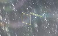
QUOTE (Phil Stooke @ Sep 7 2019, 11:47 AM) Well said, Steve. The live coverage included glimpses of this image: [attachment=45089:vikram_l...ing_area.jpg] It shows a specific landing area within the target ellipse. It should be easy to find in LRO images but so far I'm not able to identify it. The early morning illumination suggests to me it may be from the orbiter. It doesn't obviously resemble any LRO image I have seen yet. Scale is not clear, but another report in the Times of India said two specific sites 500 m by 500 m and 1.6 km apart had been picked in the landing ellipse. Phil I was able to match the perspective corrected OHRC image shown on screens of Mission Operations Complex with LROC images of the intended primary landing site, sun angle was making the scene look slightly different. https://www.youtube.com/watch?v=KJJov3tXfOU OHRC image labelled as taken on 6 September 2019 on 2030 IST (Indian Std. Time) can be seen in broadcast at 14 min. mark onwards https://www.youtube.com/watch?v=7iqNTeZAq-c&t=831 Marked "Landing Site Area" in yellow box appears to be roughly 50×65 meters in dimension. Placed a 2×2 m 'lander sized' red dot for comparison within it in attached image. Mapped the 15×8 km landing ellipse along intended landing box and primary and alternate landing sites given in LPSC 2018 paper and during broadcast on LRO QuickMap for ease of viewing In broadcast the launch commentator mentioned that the command for descent was sent 84 minutes prior to it and chosen coords were (-70.899920, 22.78110) and alternate site coords at (-68.749153, -18.46947) QUOTE (mcaplinger @ Sep 12 2019, 08:48 PM) I haven't been able to find very much technical information about this camera beyond this phone image of an old viewgraph about it which I've enhanced a little. I'll be very curious to see how well this performs; the high resolution coupled with a large number of TDI stages (oddly high, actually, I've no idea why they need so many) presents a lot of challenges. LROC NAC was a much more conservative design in most respects. [attachment=45092:ohrc.png] That slide on OHRC is snapshot I took during a livestreamed presentation of User Interaction Meet of 2016 held by ISRO's National Remote Sensing Centre. That webcast is no longer available and was mainly about Cartosat series of Earth Observation satellites. Meanwhile we might have to wait for LROC imagery a bit longer. https://aviationweek.com/awinspace/nasa-s-l...rayaan-2-lander
Attached thumbnail(s)
|
||
|
|
|
||
|
Sep 18 2019, 09:01 PM
Post
#66
|
|
|
Member Group: Members Posts: 157 Joined: 22-May 09 From: Ireland Member No.: 4792 |
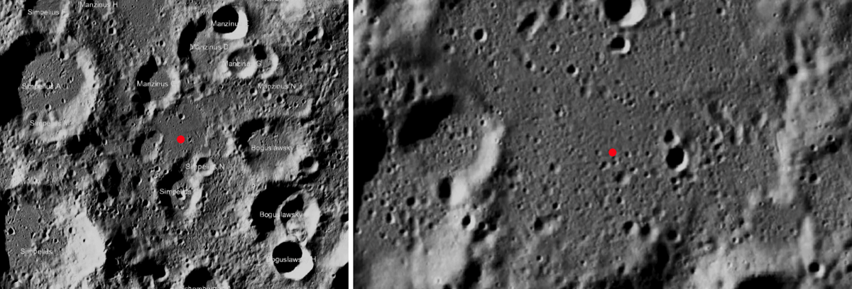
So, the site is roughly between Manzinus C and Simpelius N.
 John |
|
|
|
|
Sep 20 2019, 07:34 PM
Post
#67
|
||
|
Solar System Cartographer Group: Members Posts: 10184 Joined: 5-April 05 From: Canada Member No.: 227 |
Here's a locator map for the target area.
Phil
-------------------- ... because the Solar System ain't gonna map itself.
Also to be found posting similar content on https://mastodon.social/@PhilStooke Maps for download (free PD: https://upload.wikimedia.org/wikipedia/comm...Cartography.pdf NOTE: everything created by me which I post on UMSF is considered to be in the public domain (NOT CC, public domain) |
|
|
|
|
|
|
Sep 27 2019, 02:32 AM
Post
#68
|
|
|
Member Group: Members Posts: 103 Joined: 12-September 19 Member No.: 8664 |
|
|
|
|
|
Sep 28 2019, 02:35 PM
Post
#69
|
|
|
Senior Member Group: Members Posts: 2517 Joined: 13-September 05 Member No.: 497 |
This thread is getting out of control with Chandrayaan-1 MIP discussion. IMHO most of the recent posts should be moved to http://www.unmannedspaceflight.com/index.php?showtopic=2686
-------------------- Disclaimer: This post is based on public information only. Any opinions are my own.
|
|
|
|
|
Sep 29 2019, 04:41 PM
Post
#70
|
|
|
Solar System Cartographer Group: Members Posts: 10184 Joined: 5-April 05 From: Canada Member No.: 227 |
Mike is right. It's my fault, as I looked at the other thread and it had not been updated for 7 years, but I only expected 2 or 3 posts on the subject. Now I think there is a lot more to say on the subject and this is the wrong place for it.
A new thread might be good, but moving to the old thread would be fine too. Phil -------------------- ... because the Solar System ain't gonna map itself.
Also to be found posting similar content on https://mastodon.social/@PhilStooke Maps for download (free PD: https://upload.wikimedia.org/wikipedia/comm...Cartography.pdf NOTE: everything created by me which I post on UMSF is considered to be in the public domain (NOT CC, public domain) |
|
|
|
|
Sep 29 2019, 09:47 PM
Post
#71
|
|
|
Merciless Robot Group: Admin Posts: 8784 Joined: 8-December 05 From: Los Angeles Member No.: 602 |
C-1 MIP impact site posts moved here per request. Good call.

-------------------- A few will take this knowledge and use this power of a dream realized as a force for change, an impetus for further discovery to make less ancient dreams real.
|
|
|
|
|
Sep 30 2019, 01:33 PM
Post
#72
|
|
|
Member Group: Members Posts: 157 Joined: 22-May 09 From: Ireland Member No.: 4792 |
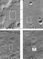
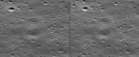
As this 'U-type' feature showed up (during a blink-comparison technique) not far from the possible/proposed Vikram site (rectangle), I'll throw it out there (some small craters visible in the hig-rez below, may be responsible for the effect).
But, these are shadowed times, and as everyone knows, such can change the look of a smooth, slightly-undulated terrain in to one unrecognisable, so take it with a pinch of salt. The second image is an extreme close-up of the feature mentioned. John 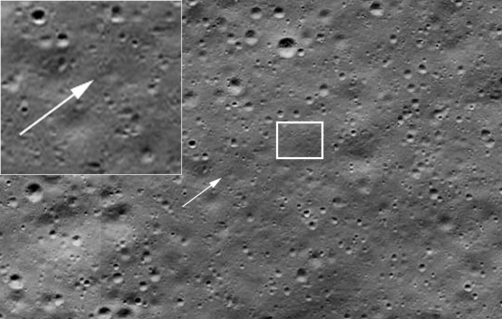 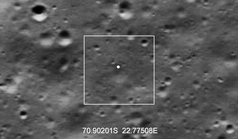
|
|
|
|
|
Oct 1 2019, 02:24 AM
Post
#73
|
||
 Member Group: Members Posts: 291 Joined: 29-December 05 From: Ottawa, ON Member No.: 624 |
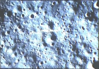
In the LROC pictures I browsed through, found some interesting braided terrain in the Chandrayaan 2 lander search area.
Attached thumbnail(s)
|
|
|
|
|
|
|
Oct 1 2019, 03:33 PM
Post
#74
|
|
|
Solar System Cartographer Group: Members Posts: 10184 Joined: 5-April 05 From: Canada Member No.: 227 |
That is formed by a spray of ejecta falling on the surface, lots of small bits together rather than one big chunk forming a secondary crater. It is a common feature, but the low relief hardly shows up in higher sun angle images.
Phil -------------------- ... because the Solar System ain't gonna map itself.
Also to be found posting similar content on https://mastodon.social/@PhilStooke Maps for download (free PD: https://upload.wikimedia.org/wikipedia/comm...Cartography.pdf NOTE: everything created by me which I post on UMSF is considered to be in the public domain (NOT CC, public domain) |
|
|
|
|
Oct 1 2019, 08:07 PM
Post
#75
|
||
|
Member Group: Members Posts: 103 Joined: 12-September 19 Member No.: 8664 |
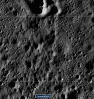
http://www.unmannedspaceflight.com/index.p...st&p=245700
Made a cross-view of planned primary landing site based on above.
Attached thumbnail(s)
|
|
|
|
|
|
|

|
Lo-Fi Version | Time is now: 5th June 2024 - 04:13 AM |
|
RULES AND GUIDELINES Please read the Forum Rules and Guidelines before posting. IMAGE COPYRIGHT |
OPINIONS AND MODERATION Opinions expressed on UnmannedSpaceflight.com are those of the individual posters and do not necessarily reflect the opinions of UnmannedSpaceflight.com or The Planetary Society. The all-volunteer UnmannedSpaceflight.com moderation team is wholly independent of The Planetary Society. The Planetary Society has no influence over decisions made by the UnmannedSpaceflight.com moderators. |
SUPPORT THE FORUM Unmannedspaceflight.com is funded by the Planetary Society. Please consider supporting our work and many other projects by donating to the Society or becoming a member. |
|