Unmanned landing sites from LRO, Surveyors, Lunas, Lunakhods and impact craters from hardware impacts |

  |
Unmanned landing sites from LRO, Surveyors, Lunas, Lunakhods and impact craters from hardware impacts |
 Nov 4 2020, 04:03 AM Nov 4 2020, 04:03 AM
Post
#181
|
|
|
Solar System Cartographer  Group: Members Posts: 10150 Joined: 5-April 05 From: Canada Member No.: 227 |
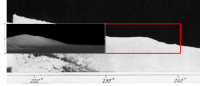
The lander is tilted so that its top is pointing towards the east. The image strip is looking down at the foreground on the east and up into the sky on the west - just catching he horizon at the bottom of the panorama. The trouble is, we don't know if that means it is sitting on a small rock or a crater wall. If it's a crater wall it is on the western inner wall of the crater so it faces towards the east - but there is no evidence in the image to say that is what it has to be. It could be on a small rock on otherwise level ground.
Your location is not very far from the hills to the south, and I think they should be visible in the southern part of the panorama. I would feel more comfortable being another 10 km north to get those hills below the horizon. The Soviet coordinates came with a big uncertainty, plus or minus about 15 km. An exact distance from a hill of any given height is difficult to state because the horizon could be formed by a local rise, not an ideal horizon on a smooth sphere. The crash stage - the discarded landing rocket - should be visible nearby as well, substantially larger than the lander and probably mostly intact as it was also travelling at low speed. -------------------- ... because the Solar System ain't gonna map itself.
Also to be found posting similar content on https://mastodon.social/@PhilStooke NOTE: everything created by me which I post on UMSF is considered to be in the public domain (NOT CC, public domain) |
 |
 
|
|
Nov 26 2020, 11:06 AM
Post
#182
|
|
|
Junior Member Group: Members Posts: 38 Joined: 7-October 20 Member No.: 8895 |
QUOTE (Phil Stooke @ Nov 4 2020, 09:33 AM)  The lander is tilted so that its top is pointing towards the east. The image strip is looking down at the foreground on the east and up into the sky on the west - just catching he horizon at the bottom of the panorama. The trouble is, we don't know if that means it is sitting on a small rock or a crater wall. If it's a crater wall it is on the western inner wall of the crater so it faces towards the east - but there is no evidence in the image to say that is what it has to be. It could be on a small rock on otherwise level ground. Your location is not very far from the hills to the south, and I think they should be visible in the southern part of the panorama. I would feel more comfortable being another 10 km north to get those hills below the horizon. The Soviet coordinates came with a big uncertainty, plus or minus about 15 km. An exact distance from a hill of any given height is difficult to state because the horizon could be formed by a local rise, not an ideal horizon on a smooth sphere. The crash stage - the discarded landing rocket - should be visible nearby as well, substantially larger than the lander and probably mostly intact as it was also travelling at low speed. I believe the previous picture might not be the luna9 landing site as the craters surrounding it are too large (They are nearly 10m in Size whereas from your pictures its supposed to be less than 1m or 2m in diameter) And the most important thing I found out is the landing location of Luna13 is 440km from Luna9 (from Soviet sources & papers). If you calculate the distance between Luna9 (7.13, 295.63) and Luna13 (18.87, 297.95)..it comes to around only 390 kms.. so Luna9 might be have landed South of the intended landing site (If we find Luna 13 then we must be able to find Luna 9 sooner) |
|
|
|
|
Nov 26 2020, 07:33 PM
Post
#183
|
|
 Senior Member Group: Members Posts: 2530 Joined: 20-April 05 Member No.: 321 |
The process here reminds me to a fair extent of what I go through when I take pictures of a star field trying to locate a point object, such as a comet, quasar, dim star, or Pluto. Pluto is invariably surrounded by many brighter stars and so I must compare the stars in my image to the finder image. This is in principle not a challenge because a match always exists and can always be found, but in practice an imperfect mount alignment combined with the time pressure of making sure my telescope is aligned in time to take longer-exposure images it can turn into 30 minutes of high stress and I find myself doing almost exactly what you are doing in this thread here.
So I wonder about an algorithmic approach to solving this problem. Of course, one big difference is that sky field images consist, essentially, of points of varying brightness, with pure black between them. The lunar map analog would be craters, and that's a strong but imperfect analog, with other variations in topography being part of the reality and hard to abstract into something that an algorithm would represent and handle well. If there are enough outstanding mysteries to solve, it might be worth pursuing an algorithm to facilitate the process. Our eyes are wonderful at identifying patterns of many kinds, but aligning maps of star fields or of craters is not one of them. |
|
|
|
|
Nov 26 2020, 08:13 PM
Post
#184
|
|
 Senior Member Group: Members Posts: 4246 Joined: 17-January 05 Member No.: 152 |
I guess you're talking about plate solving - the process of automatically matching a star field image to a map. I could imagine applying plate solving software to matching a projected local lunar panorama to maps. Someone would need to identify craters and create an effective "star map", with the position of each "star" representing the crater location and the brightness of each "star" representing its size. Plate solvers incorporate tolerances that could take into account errors in the panorama due to topography etc. But that would be a huge amount of work unless it could be automated somehow.
Otherwise some more generic image matching might work, if maps and panoramas had similar lighting? |
|
|
|
|
Nov 26 2020, 09:40 PM
Post
#185
|
|
|
Solar System Cartographer Group: Members Posts: 10150 Joined: 5-April 05 From: Canada Member No.: 227 |
This problem is not really suitable for the kind of algorithm being suggested here. A problem that would be suitable would be trying to match a descent image taken by Chang'e 5 with an LRO image to locate the landing area. That's two overhead views. With Luna 9 we are looking at a very low angle oblique image (the camera was about 50 cm above the surface) and a restricted area of good coverage (looking down-sun there are no visible details, looking up-sun we are only seeing an area about 2 or 3 m wide as the camera was tilted down in that direction) and everywhere the image contains bad relief distortions. My reprojected Curiosity panoramas are much more amenable to comparison with a HiRISE image because of the higher viewpoint and 360 degree coverage, but even there we are helped by knowing pretty closely where to look (and I have made bad mistakes sometimes). For Luna 9 we could be looking anywhere within a circle 30 km in diameter (maybe a bit more).
Eventually it will be found. The LRO image will show the lander, the landing stage, maybe the air bag pieces, a brightened blast zone around the landing stage site, and several craters and rocks recognizable in the panorama. When it's found it will be immediately obvious, but until then we will just have rocks and craters in some vague semblance of the expected pattern. I think Luna 13 will be easier to find because of a better view of middle distance features. Phil -------------------- ... because the Solar System ain't gonna map itself.
Also to be found posting similar content on https://mastodon.social/@PhilStooke NOTE: everything created by me which I post on UMSF is considered to be in the public domain (NOT CC, public domain) |
|
|
|
|
Feb 9 2021, 01:32 AM
Post
#186
|
|||
|
Junior Member Group: Members Posts: 38 Joined: 7-October 20 Member No.: 8895 |
I believe Luna9 will be easier to find as the hill that is visible on the image might be the one that is to the east of Planitia Descensus and searching in and around the area found something like these.. but need to see what exactly they are those.. They might be the debris as they nearly match the distance the hills can be seen from the pics..
Attached thumbnail(s)
|
||
|
|
|
||
|
Jul 28 2021, 06:28 PM
Post
#187
|
|||
|
Junior Member Group: Members Posts: 38 Joined: 7-October 20 Member No.: 8895 |
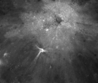
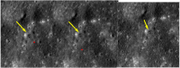
QUOTE (Phil Stooke @ Nov 27 2020, 03:10 AM) This problem is not really suitable for the kind of algorithm being suggested here. A problem that would be suitable would be trying to match a descent image taken by Chang'e 5 with an LRO image to locate the landing area. That's two overhead views. With Luna 9 we are looking at a very low angle oblique image (the camera was about 50 cm above the surface) and a restricted area of good coverage (looking down-sun there are no visible details, looking up-sun we are only seeing an area about 2 or 3 m wide as the camera was tilted down in that direction) and everywhere the image contains bad relief distortions. My reprojected Curiosity panoramas are much more amenable to comparison with a HiRISE image because of the higher viewpoint and 360 degree coverage, but even there we are helped by knowing pretty closely where to look (and I have made bad mistakes sometimes). For Luna 9 we could be looking anywhere within a circle 30 km in diameter (maybe a bit more). Eventually it will be found. The LRO image will show the lander, the landing stage, maybe the air bag pieces, a brightened blast zone around the landing stage site, and several craters and rocks recognizable in the panorama. When it's found it will be immediately obvious, but until then we will just have rocks and craters in some vague semblance of the expected pattern. I think Luna 13 will be easier to find because of a better view of middle distance features. Phil Phil whether the rocket stage impact of Luna9 would look similar to this? Not sure but this one has a diameter of 5~8m & irregular in shape (Whether a mass of 1400kg hitting at 22 km/hr would make such a impact?)..
Attached thumbnail(s)
|
||
|
|
|
||
|
Jul 29 2021, 04:18 AM
Post
#188
|
|
|
Solar System Cartographer Group: Members Posts: 10150 Joined: 5-April 05 From: Canada Member No.: 227 |
I think if an object hits the surface at 22 km/h it would be damaged but it would still remain largely intact and would show up in the images as a single object. It would be similar to a large rock in appearance. it would probably not look like this, a crater with rays. To me this looks like a natural crater formed by a high speed impact. If it was the Luna 9 braking rocket stage the lander would be close to it and the pattern of craters visible around the lander in the panorama should be visible as well.
Phil -------------------- ... because the Solar System ain't gonna map itself.
Also to be found posting similar content on https://mastodon.social/@PhilStooke NOTE: everything created by me which I post on UMSF is considered to be in the public domain (NOT CC, public domain) |
|
|
|
|
Jul 29 2021, 08:29 AM
Post
#189
|
||
|
Junior Member Group: Members Posts: 38 Joined: 7-October 20 Member No.: 8895 |
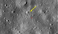
QUOTE (Phil Stooke @ Jul 29 2021, 09:48 AM) I think if an object hits the surface at 22 km/h it would be damaged but it would still remain largely intact and would show up in the images as a single object. It would be similar to a large rock in appearance. it would probably not look like this, a crater with rays. To me this looks like a natural crater formed by a high speed impact. If it was the Luna 9 braking rocket stage the lander would be close to it and the pattern of craters visible around the lander in the panorama should be visible as well. Phil Not sure my 22 km/hr estimate was right because from here - https://nssdc.gsfc.nasa.gov/nmc/spacecraft/...d=1966-006A.The article says that capsule impacted at 22 km/hr and didn't mention anything about the rocket stage. https://nssdc.gsfc.nasa.gov/nmc/spacecraft/...on?id=1965-044A - Luna8 one..
Whether it would be possible to have the velocity reduced from 9300 km/hr to 22km/hr under 50 seconds by 45000N Engine from 75km altitude to 250m? I am not sure about the exact details but there might be more to it as the details when the probe was ejected are still a mystery..Luna8 page on NASA says a boom was released from the bottom of the spacecraft to check the altitude but the pnot sure whether Luna9 capsule was ejected when the spacecraft was hovering? and after ejection it seems the 4 Vernier engines were cut off which might have resulted in spacecraft crashing on to the surface. The only way to verify this is to look for an impact similar to this near Luna13.. (Wish we had more details) Location : https://quickmap.lroc.asu.edu/query?extent=...AyAbwF8BdC0yioA (Lat: 7.37233 Lon: 295.26334) - The small crater is about 4~5m in size..This might be even Luna8 if this is Luna9 rocket stage impact then Luna9 might be lying to North west of the impact point and the area also has depression from West to East..
Attached thumbnail(s)
|
|
|
|
|
|
|
Oct 16 2021, 03:09 AM
Post
#190
|
||
|
Junior Member Group: Members Posts: 38 Joined: 7-October 20 Member No.: 8895 |
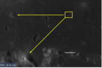
@Phil - Luna9 might have landed to further east of
From 3D model of the area, I believe the hill we are seeing SW at 240 degrees is the one to the left of Planitia Descensus. Luna9 might have landed between 7.20-7.50N and 296-297E (It might have been possibly inside the crater or an area that obscured Planitia Descensus with the hill to the right of Planitia Descensus being visible) http://target.lroc.asu.edu/qm3d/o2w_3d_815...10_0_100_101_0/
Attached thumbnail(s)
|
|
|
|
|
|
|
Jan 24 2022, 08:57 AM
Post
#191
|
|||
|
Junior Member Group: Members Posts: 38 Joined: 7-October 20 Member No.: 8895 |
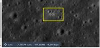
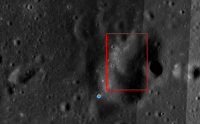
@Phil
Whether this could be one of the Luna9's Debris? Are we looking for something similar to this? The 2nd picture is comparison of 3 different LRO images side by side
Attached thumbnail(s)
|
||
|
|
|
||
|
Jan 24 2022, 09:50 PM
Post
#192
|
|
|
Solar System Cartographer Group: Members Posts: 10150 Joined: 5-April 05 From: Canada Member No.: 227 |
It is a nice candidate. The landing stage should be visible somewhere nearby, and could possibly be the object in a small crater WNW of the 'lander' object, and larger than the lander. I would be happier if the crater SE of the lander in the panorama was more visible here, and if the area around the putative landing stage was brighter. So far, though, I would say this is the best candidate I have seen.
Can you show us where this is? Phil -------------------- ... because the Solar System ain't gonna map itself.
Also to be found posting similar content on https://mastodon.social/@PhilStooke NOTE: everything created by me which I post on UMSF is considered to be in the public domain (NOT CC, public domain) |
|
|
|
|
Jan 25 2022, 12:59 AM
Post
#193
|
|
|
Junior Member Group: Members Posts: 38 Joined: 7-October 20 Member No.: 8895 |
QUOTE (Phil Stooke @ Jan 25 2022, 03:20 AM) It is a nice candidate. The landing stage should be visible somewhere nearby, and could possibly be the object in a small crater WNW of the 'lander' object, and larger than the lander. I would be happier if the crater SE of the lander in the panorama was more visible here, and if the area around the putative landing stage was brighter. So far, though, I would say this is the best candidate I have seen. Can you show us where this is? Phil Here is the location - https://quickmap.lroc.asu.edu/layers?extent...bREONLRfImq7ioA Lat:7.42075 Long:296.93447 I am not sure exactly whether this is the landing stage or we are looking at Luna9 itself. There are objects to NorthWest and SouthWest of this region looking liking debris but it's hard to tell..Will search more on the surrounding area.. |
|
|
|
|
Jan 25 2022, 02:48 AM
Post
#194
|
|
|
Senior Member Group: Members Posts: 2082 Joined: 13-February 10 From: Ontario Member No.: 5221 |
Probably the best thread to post this (mods, please move if the LROC thread is better) It appears that DSCOVR'S second stage will be impacting the moon in a little over a month (far side):
https://www.projectpluto.com/temp/dscovr.htm The chances of witnessing the impact by orbiters is tough, but a very fresh crater should have some scientific value (and the first ever unintentional impact, at least that has been precisely calculated). |
|
|
|
|
Jan 25 2022, 08:15 AM
Post
#195
|
|
|
Solar System Cartographer Group: Members Posts: 10150 Joined: 5-April 05 From: Canada Member No.: 227 |
Thanks for pointing that out! Another point on the map.
Phil -------------------- ... because the Solar System ain't gonna map itself.
Also to be found posting similar content on https://mastodon.social/@PhilStooke NOTE: everything created by me which I post on UMSF is considered to be in the public domain (NOT CC, public domain) |
|
|
|
|

|
Lo-Fi Version | Time is now: 24th April 2024 - 11:42 AM |
|
RULES AND GUIDELINES Please read the Forum Rules and Guidelines before posting. IMAGE COPYRIGHT |
OPINIONS AND MODERATION Opinions expressed on UnmannedSpaceflight.com are those of the individual posters and do not necessarily reflect the opinions of UnmannedSpaceflight.com or The Planetary Society. The all-volunteer UnmannedSpaceflight.com moderation team is wholly independent of The Planetary Society. The Planetary Society has no influence over decisions made by the UnmannedSpaceflight.com moderators. |
SUPPORT THE FORUM Unmannedspaceflight.com is funded by the Planetary Society. Please consider supporting our work and many other projects by donating to the Society or becoming a member. |
|