T43 Flyby (May 12, 2008), Tui Regio, Tortola Facula (the Snail), and NE Shangri-La |

  |
T43 Flyby (May 12, 2008), Tui Regio, Tortola Facula (the Snail), and NE Shangri-La |
 May 7 2008, 12:51 AM May 7 2008, 12:51 AM
Post
#1
|
|
 Senior Member  Group: Moderator Posts: 2785 Joined: 10-November 06 From: Pasadena, CA Member No.: 1345 |
T43 Mission description is now up!
http://saturn.jpl.nasa.gov/multimedia/prod...description.pdf Some highlights:
-Mike -------------------- Some higher resolution images available at my photostream: http://www.flickr.com/photos/31678681@N07/
|
 |
 
|
|
May 7 2008, 12:56 AM
Post
#2
|
|
|
Senior Member Group: Moderator Posts: 2785 Joined: 10-November 06 From: Pasadena, CA Member No.: 1345 |
Rev 67 Mission description is up!
http://ciclops.org/view.php?id=4887 Quote from the T43 description: "The RADAR swath will also cross a hypothesized large impact basin that may cover much of Xanadu."  Just when you thought Menrva was pretty big....Titan mighta done got smacked. -Mike -------------------- Some higher resolution images available at my photostream: http://www.flickr.com/photos/31678681@N07/
|
|
|
|
|
May 7 2008, 02:03 AM
Post
#3
|
|
|
Member Group: Members Posts: 813 Joined: 29-December 05 From: NE Oh, USA Member No.: 627 |
Xanadu and the regions south fascinate me. This huge mass of karst like dissected terrain covered in bright smurst (?), and then the possible cryovolcanics of Hotei, Tortula, and Tui...
Combine this SAR coverage with T41 and what a treat it will be to see all the data released. HINT HINT to Radar team.  what a treat is in store.... Craig |
|
|
|
|
May 7 2008, 09:41 AM
Post
#4
|
|
|
Merciless Robot Group: Admin Posts: 8783 Joined: 8-December 05 From: Los Angeles Member No.: 602 |
QUOTE (Juramike @ May 6 2008, 04:56 PM)  Just when you thought Menrva was pretty big....Titan mighta done got smacked. -Mike Wouldn't be a bit surprised...seems like most of the larger ice moons have been whacked pretty badly (Odysseus on Tethys springs to mind). I wonder sometimes if all these big hits were more or less contemporaneous? If so, what might be very interesting is to see how erosional, subsurface, and of course chemical processes may have altered the scar. -------------------- A few will take this knowledge and use this power of a dream realized as a force for change, an impetus for further discovery to make less ancient dreams real.
|
|
|
|
|
May 8 2008, 05:42 AM
Post
#5
|
||
|
Member Group: Members Posts: 699 Joined: 1-April 08 From: Minnesota ! Member No.: 4081 |
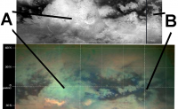
Hmmm ...... I can't honestly say I see a huge impact basin in Xanadu A (unless Hotei Arcus is the surviving rim of it). The big circular tectonic feature B at 0 degree longitude however sure looks like an old impact basin.
|
|
|
|
|
|
|
May 8 2008, 11:52 AM
Post
#6
|
|
 Member Group: Members Posts: 610 Joined: 23-February 07 From: Occasionally in Columbia, MD Member No.: 1764 |
QUOTE (titanicrivers @ May 8 2008, 01:42 AM) Hmmm ...... I can't honestly say I see a huge impact basin in Xanadu A (unless Hotei Arcus is the surviving rim of it). The big circular tetonic feature B at 0 degree longitude however sure looks like an old impact basin. I agree. I have not been shown the VIMS team's purported evidence for Xanadu being an impact so I am unpersuaded. Seems pretty unlikely overall, and there is certainly nothing in the T13 SAR to support that interpretation. |
|
|
|
|
May 8 2008, 03:35 PM
Post
#7
|
|
|
Senior Member Group: Moderator Posts: 2785 Joined: 10-November 06 From: Pasadena, CA Member No.: 1345 |
The T13 RADAR swath of Xanadu showed a large number or tectonic ridges (?) in cool-o swirly patterns. The T13 RADAR swath of Xanadu also shows a slightly larger than normal percentage (for an equatorial region) number of putative smaller craters. This would imply that the cratering record is better preserved on this terrain.
My interpretation is that all the swirliness must have happened a long time ago, and then the craters formed with decreasing amounts of crater degradation drama. (Compared to other non-Xanadu equatorial regions.) I suspect Xanadu might be the Titan equivalent of the Piedmont region of the Carolinas. Lots of excitement a long time ago, but then several hundred million years of Not Much Happening. (On Titan multiply the timescale by 10). So if it was an impact that happened post-swirly time, it should be very obvious, like most of the smaller craters. It it was big impact that happened pre-swirly time, it could be really, really mangled up, twisted up, eroded out, and totally ch*nked up. It might not be evident by RADAR (or even altimetry). Even on Earth many of the big impact craters are not immediately obvious. Chicxulub is a great example. Check out the National Geographic article here. And Chicxulub is only 65 million years old. Imagine how difficult it would be to tease out Sudbury or Vredefort crater's structure after a few more billion years of Earth's crustal spasms and surface erosion. -Mike -------------------- Some higher resolution images available at my photostream: http://www.flickr.com/photos/31678681@N07/
|
|
|
|
|
May 8 2008, 06:33 PM
Post
#8
|
|
 Senior Member Group: Members Posts: 2530 Joined: 20-April 05 Member No.: 321 |
QUOTE (nprev @ May 7 2008, 01:41 AM) I wonder sometimes if all these big hits were more or less contemporaneous? I remember seeing the graph once of bombardment intensity as a function of the age of the solar system. (Surely somewhat speculative, and there may be differences from inner to outer solar system, or even the Saturn system vs. the Uranus system, but let's put that aside.) Basically, it's a tale of exponential decay. Every impactor in its planet-crossing orbit had a half-life until it met its doom, and while Jupiter and Saturn clobbered almost everything, the satellites and terrestrial planets got a proportionate, lesser fraction. So in a nutshell, almost all of the impacts (especially the big ones) ever to occur happened early, and therefore more or less contemporaneously. There must have been, in all such cases, a period of saturation impacting where Copernicus-sized craters happened almost daily and erased one another, not to mention when an Imbrium-sized impact would pave over hundreds of them. The big basins we see are the ones that postdate the saturation period (and crustal solidification, which would have happened almost immediately with Dione and Tethys; slower with Mercury and Titan). In relative terms, we should suspect, yes, that they're all roughly contemporaneous and about 4 GYA. The oddity would be those cases where big impacts happened later. It must have happened, but it would be the minority. The other thing is that the Saturn system has an unparalleled density of medium-sized bodies. Catastrophic impacting might have lasted longer there than elsewhere. On the other hand, the tidal forces pulling everything to the equatorial plane should have sharply increased the number of impacts in comparison with solar orbit in the Earth-Mars vicinity. So I guess that not much in Saturn orbit could have lasted past 4 GYA. Real modeling should give a better answer than any qualitative discussion, but I guess, in a nutshell, that not much was left by 3 GYA to create big impacts. And most of what there was would have been destined to hit Saturn, not the smaller bodies. |
|
|
|
|
May 11 2008, 01:46 AM
Post
#9
|
|||
|
Member Group: Members Posts: 699 Joined: 1-April 08 From: Minnesota ! Member No.: 4081 |
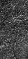
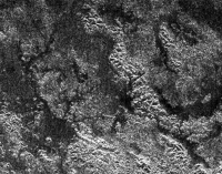
I can see Xanadu as older higher ground rather than a basin. Even though it may have more craterform structures none of them look very recent and a few are altered by what is still likely altering Xanadus topography namely fluvial erosional activity. This is evidenced (especially the western portion which has possible daily am drizzle) by the many channels with dendritic branches (better known as rivers, see A below) that appear unaltered by craters or dunes and in the central hilly region where short, stubby radar dark channels and elongated possible lakes are found (see B below). These may be sapping-spring-like fluvial alterations. I wouldn't be surprised if Xanadu was riddled with the same channels that Huygens saw in the brighter highlands at the tip of Adiri.
That Xanadu is not covered with dunes suggest its higher ground and must be swept clear of the sintered schizzle falling everywhere from above. Maybe it only seems to have more craters because the sand seas are covering craters on the lower terrain lowering the count there. Hopefully in a few weeks well have some more interesting images to ponder and speculate about. A
|
||
|
|
|
||
|
May 11 2008, 04:53 AM
Post
#10
|
|
|
Member Group: Members Posts: 699 Joined: 1-April 08 From: Minnesota ! Member No.: 4081 |
Being a Titan-o-maniac I like to follow the Titan flyby's by logging on to the official Cassini-Huygens web page and clicking on 'Where is Cassini Now' on the right side panel. This pulls up David Seal's Solar System Simulator and one can usually get a nice appreciation of what an astronaut piloting Cassini might see during the flyby. There appears to be a problem with the Simulator however in that the moon panel appears 'stuck' on Enceladus at 600,000 km or so. I may be wrong but this may have happened weeks ago during a close Enceladus flyby. ??? Does any one else have this problem or know of a fix for it?
|
|
|
|
|
May 11 2008, 02:49 PM
Post
#11
|
|
|
Member Group: Members Posts: 699 Joined: 1-April 08 From: Minnesota ! Member No.: 4081 |
QUOTE (titanicrivers @ May 10 2008, 11:53 PM) Being a Titan-o-maniac I like to follow the Titan flyby's by logging on to the official Cassini-Huygens web page and clicking on 'Where is Cassini Now' on the right side panel. This pulls up David Seal's Solar System Simulator and one can usually get a nice appreciation of what an astronaut piloting Cassini might see during the flyby. There appears to be a problem with the Simulator however in that the moon panel appears 'stuck' on Enceladus at 600,000 km or so. I may be wrong but this may have happened weeks ago during a close Enceladus flyby. ??? Does any one else have this problem or know of a fix for it? Looks like I'm only half correct: the distance from Enceladus changed appropriately overnite; however it's still Enceladus in the encounter window, and with the T-43 encounter just 19 hrs away! We'll see if it changes to Titan today! |
|
|
|
|
May 11 2008, 03:18 PM
Post
#12
|
|
 Senior Member Group: Members Posts: 3648 Joined: 1-October 05 From: Croatia Member No.: 523 |
QUOTE (titanicrivers @ May 11 2008, 04:49 PM) with the T-43 encounter just 19 hrs away! We'll see if it changes to Titan today! There's alredy been a few Titan flybys after the March Enceladus flyby and the view still shows Enceladus. I don't think it's going to change soon. If you want to see Titan instead, use the Solar System Simulator instead. -------------------- |
|
|
|
|
May 11 2008, 03:42 PM
Post
#13
|
|||||
|
Senior Member Group: Moderator Posts: 2785 Joined: 10-November 06 From: Pasadena, CA Member No.: 1345 |
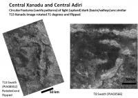
My impression is that central Xanadu and central Adiri are similar in many ways.
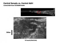
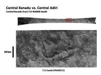
Craters numbers similar, erosion state similar, but degraded crater aspect different. The visible impact craters (my personal speculation) have a different aspect in Xanadu. The Fresh crater pretty much similar (entry 4 in Post 2, Erosion on Titan thread, link here). However, the outer rims of Degraded craters seem more distinct and sharp-edged by SAR Radar on Xanadu (entries 34, 35, 36, 37, and 40, Post 5, Erosion on Titan thread, link here) than compared to Adiri. My speculation is that the erosion environment or material composition/structure is different on Xanadu compared to Adiri. The overall crater counts and erosive state (again, my speculation) on both Adiri and Xanadu support that both surfaces are pretty old (since you do see about the same crater population), and both have been subjected to intense weathering. It is just that the erosion style on Xanadu appears different. Tectonic ridge patterns swirly shapes very similar Like in central Adiri, in central Xanadu there is an overall trend of steep ridges and valleys/basin to be trending EW - much of it looking like the ski tracks of Adiri. There also appears to be repeating ridges and valleys trending NW-SE and in the western part of Central Xanadu some ridges/valleys run NE-SW. Overall, the pattern is pretty complex. [Adiri is more simple: EW trending tectonic ridges, with a N-S undulation pattern]. Xanadu also has a very similar pattern to the concentric ridge/basin structure surrounding the shark fin feature of central Adiri. The graphic below shows the shark fin of central Adiri (seen in PIA03566):
And the graphic below shows a similar feature in central Xanadu (seen in PIA08532). It is about the same scale.
For grins and giggles, I rotated the Xanadu feature (and flipped it about the horizontal axis) to try and line it up to the Adiri pattern:
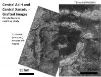
And for even more fun, I rotated, rescaled and grafted it onto the Adiri feature in a split screen (on the left is Xanadu an on the right is Adiri). They match pretty well:
Whatever was responsible for the tectonic ridges and swirly patterns on Adiri, seems to also have operated on Xanadu. Valleys different Adiri clearly has dune sands that have invaded and filled the basins between the ridges. Xanadu still has more RADAR-bright valleys with no evidence of dunes filling the valleys. This could be due to topography , if overall Xanadu is higher than Adiri. Or it could be due to isolation - the W Xanadu terrain (clearly different from central Xanadu) isolates the region (topographically? large pits acting as sand traps?) from saltating dune sand particles. Altimetry will at least show if Xanadu valleys are at the same height as Adiri basins (or at least relative to Shangri-La basin). Xanadu vs. Adiri - Different stuff? A big difference is in scatterometry and VIMS. VIMS shows Xanadu to be very bright, with Hotei Arcus and Tui Regio seeming to be very different from other portions of Titan. However, 5-cm bright terrain has recently been found partly covered in dunes in NW Fensal Radiometry and scatterometry shows Xanadu to be very different from Adiri. It has a very low brightness temperature (low emissivity, radiometry dark) and has a large radar cross-section (high scatterer, scatterometry bright). Together, this implies a higher amount of volume scatter for Xanadu compared to Adiri. These result imply that the two terrains are materially (or structurally) very different. One of the really exciting things happening during the T43 flyby will be the radiometry of the E portion of Xanadu and W Fensal/Aztlan/Quivira/Tseghi). This will fill in the radiometry map and help show differences and similarities between Xanadu, Quivira and the VIMS 5cm-bright material in NW Fensal. Unfortunately, radiometry data is usually only released in publications so it may be a while before we see the results. Overall, while Xanadu may be made of different materials and might have a different coating compared to Adiri, the forces that acted upon the two terrains seem similar. Even though Xanadu is weird, its not too weird. I think these latest few flybys (T41 and T43) will help fit Xanadu in to the rest of the Titan terrain. -Mike -------------------- Some higher resolution images available at my photostream: http://www.flickr.com/photos/31678681@N07/
|
||||
|
|
|
||||
|
May 11 2008, 05:24 PM
Post
#14
|
|
|
Member Group: Members Posts: 699 Joined: 1-April 08 From: Minnesota ! Member No.: 4081 |
QUOTE (ugordan @ May 11 2008, 10:18 AM) There's alredy been a few Titan flybys after the March Enceladus flyby and the view still shows Enceladus. I don't think it's going to change soon. If you want to see Titan instead, use the Solar System Simulator instead. Thanks! I'll follow things with the SSS link until the Cassini web page is back to Titan. |
|
|
|
|
May 13 2008, 02:13 PM
Post
#15
|
||
|
Senior Member Group: Moderator Posts: 2785 Joined: 10-November 06 From: Pasadena, CA Member No.: 1345 |
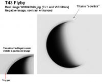
T43 Raw images are up!
Most of the images posted so far are not using the best filter set for surface imaging (CB3 and CL1 or CL2): [NAC CL1 (on Filter Wheel 1 of the Narrow Angle Camera) and CB3 (on Filter Wheel 2 of the Narrow Angle Camera) WAC CB3 (on Filter Wheel 1 of the Wide Angle Camera and CL2 (on Filter Wheel 2 of the Wide Angle Camera]). There is a really nice raw image showing the detached haze layers. W00045323.jpg Here is a negative image contrast-enhanced and annotated. It looks like there are at least two detached haze layers nicely visible in the image. The gap seems a little bigger and more obvious in the upper (= N?) portion of the image:
-Mike [EDIT: added filter wheel information of NAC and WAC] -------------------- Some higher resolution images available at my photostream: http://www.flickr.com/photos/31678681@N07/
|
|
|
|
|
|
|

|
Lo-Fi Version | Time is now: 26th April 2024 - 04:33 AM |
|
RULES AND GUIDELINES Please read the Forum Rules and Guidelines before posting. IMAGE COPYRIGHT |
OPINIONS AND MODERATION Opinions expressed on UnmannedSpaceflight.com are those of the individual posters and do not necessarily reflect the opinions of UnmannedSpaceflight.com or The Planetary Society. The all-volunteer UnmannedSpaceflight.com moderation team is wholly independent of The Planetary Society. The Planetary Society has no influence over decisions made by the UnmannedSpaceflight.com moderators. |
SUPPORT THE FORUM Unmannedspaceflight.com is funded by the Planetary Society. Please consider supporting our work and many other projects by donating to the Society or becoming a member. |
|