Heading south from Cape York, Opportunity's post-conjunction adventures / Sol 3291 - 3387 |

  |
Heading south from Cape York, Opportunity's post-conjunction adventures / Sol 3291 - 3387 |
 Jul 20 2013, 02:38 AM Jul 20 2013, 02:38 AM
Post
#361
|
|
 Senior Member  Group: Moderator Posts: 3431 Joined: 11-August 04 From: USA Member No.: 98 |
That small crater we were talking about to the east on sol 3369? That's crater "Charlie Brown" apparently. They did a drive-by of it on sol 3371.
|
 |
 
|
|
Jul 22 2013, 11:19 AM
Post
#362
|
|
 Senior Member Group: Members Posts: 1619 Joined: 12-February 06 From: Bergerac - FR Member No.: 678 |
Sol 3374 complete panoramic :
 We can see a lot of features like Cape York, far away, to the left, Cape Tribulation which became visible due to the drive estward, and of course Solander Point. 
-------------------- |
|
|
|
|
Jul 22 2013, 12:01 PM
Post
#363
|
||
|
Solar System Cartographer Group: Members Posts: 10159 Joined: 5-April 05 From: Canada Member No.: 227 |
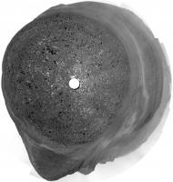
Finally! A full panorama. Here's a circular version of it.
Phil
-------------------- ... because the Solar System ain't gonna map itself.
Also to be found posting similar content on https://mastodon.social/@PhilStooke Maps for download (free PD: https://upload.wikimedia.org/wikipedia/comm...Cartography.pdf NOTE: everything created by me which I post on UMSF is considered to be in the public domain (NOT CC, public domain) |
|
|
|
|
|
|
Jul 22 2013, 05:11 PM
Post
#364
|
|
|
Senior Member Group: Moderator Posts: 4279 Joined: 19-April 05 From: .br at .es Member No.: 253 |
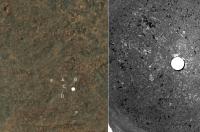
Nice! FWIW, this drive was about 50m SSE.
Map update soon... Edit: Even with this 360º mosaic I'm finding really difficult to correlate it with the HiRISE background. No clue. 
|
|
|
|
|
Jul 22 2013, 06:04 PM
Post
#365
|
|
|
Solar System Cartographer Group: Members Posts: 10159 Joined: 5-April 05 From: Canada Member No.: 227 |
Right - we've never had such a difficult place to work with.
Phil -------------------- ... because the Solar System ain't gonna map itself.
Also to be found posting similar content on https://mastodon.social/@PhilStooke Maps for download (free PD: https://upload.wikimedia.org/wikipedia/comm...Cartography.pdf NOTE: everything created by me which I post on UMSF is considered to be in the public domain (NOT CC, public domain) |
|
|
|
|
Jul 22 2013, 06:19 PM
Post
#366
|
|
|
Senior Member Group: Moderator Posts: 4279 Joined: 19-April 05 From: .br at .es Member No.: 253 |
True. I still remember how easy it was while travelling by the dune seas.
|
|
|
|
|
Jul 22 2013, 06:46 PM
Post
#367
|
|
|
Senior Member Group: Moderator Posts: 3431 Joined: 11-August 04 From: USA Member No.: 98 |
Yes, see what you've been missing on vacation?
That is, mostly eyestrain.Here's my guess on the color map. |
|
|
|
|
Jul 22 2013, 07:53 PM
Post
#368
|
||
|
Solar System Cartographer Group: Members Posts: 10159 Joined: 5-April 05 From: Canada Member No.: 227 |
Aaargh!
Phil
(C and D refer to white spots, left of C and above D) -------------------- ... because the Solar System ain't gonna map itself.
Also to be found posting similar content on https://mastodon.social/@PhilStooke Maps for download (free PD: https://upload.wikimedia.org/wikipedia/comm...Cartography.pdf NOTE: everything created by me which I post on UMSF is considered to be in the public domain (NOT CC, public domain) |
|
|
|
|
|
|
Jul 22 2013, 07:54 PM
Post
#369
|
|
 Senior Member Group: Members Posts: 4247 Joined: 17-January 05 Member No.: 152 |
Yeah, this may be the toughest site to localize yet.
In extreme situations like this, I wonder how hard it would be to turn the 360 navcam mosaic into some kind of equal-area-ish projection to be able to compare more directly with the hirise view. Of course it would only be approximate, due to the surface being not exactly flat. Also, you'd have to estimate the scale based on the height of navcam and angle of view below horizon. Even with the inevitable distortions, shadowing effects, and scale error, it might still allow you to pinpoint the location by blinking between the navcam and orbital views and shifting one until you find good agreement. The distortions would be worse farther away, but maybe you'd only need to go out 30 metres or so to get a good match. |
|
|
|
|
Jul 22 2013, 08:22 PM
Post
#370
|
|
|
Solar System Cartographer Group: Members Posts: 10159 Joined: 5-April 05 From: Canada Member No.: 227 |
That is what the professionals do. Best results, of course, if the reprojection is controlled by a stereo model from the Navcam stereo pan.
Phil -------------------- ... because the Solar System ain't gonna map itself.
Also to be found posting similar content on https://mastodon.social/@PhilStooke Maps for download (free PD: https://upload.wikimedia.org/wikipedia/comm...Cartography.pdf NOTE: everything created by me which I post on UMSF is considered to be in the public domain (NOT CC, public domain) |
|
|
|
|
Jul 22 2013, 09:11 PM
Post
#371
|
|
|
Senior Member Group: Moderator Posts: 3431 Joined: 11-August 04 From: USA Member No.: 98 |
Ah, yes, that's much more convincing. I've updated my position to match Phil's.
|
|
|
|
|
Jul 22 2013, 09:55 PM
Post
#372
|
|
|
Senior Member Group: Moderator Posts: 4279 Joined: 19-April 05 From: .br at .es Member No.: 253 |
Yes, I think that's it. And in this case this position fits quite well with the one calculated by the rover itself.
|
|
|
|
|
Jul 23 2013, 08:30 AM
Post
#373
|
|
 Senior Member Group: Members Posts: 1085 Joined: 19-February 05 From: Close to Meudon Observatory in France Member No.: 172 |
QUOTE (Ant103 @ Jul 22 2013, 01:19 PM)  Sol 3374 complete panoramic : Damia, c'est vraiment SUPERBE !!! Un grand merci ! 
|
|
|
|
|
Jul 23 2013, 11:08 AM
Post
#374
|
|
|
Senior Member Group: Members Posts: 1619 Joined: 12-February 06 From: Bergerac - FR Member No.: 678 |
Merci beaucoup Olivier
-------------------- |
|
|
|
|
Jul 23 2013, 01:37 PM
Post
#375
|
|
|
Solar System Cartographer Group: Members Posts: 10159 Joined: 5-April 05 From: Canada Member No.: 227 |
http://www.midnightplanets.com/web/MERB/im...EP2412L7M1.html
The rocks are layered like so many we've seen before, but they look like very coarse-grained, gritty layers here. Phil -------------------- ... because the Solar System ain't gonna map itself.
Also to be found posting similar content on https://mastodon.social/@PhilStooke Maps for download (free PD: https://upload.wikimedia.org/wikipedia/comm...Cartography.pdf NOTE: everything created by me which I post on UMSF is considered to be in the public domain (NOT CC, public domain) |
|
|
|
|

|
Lo-Fi Version | Time is now: 6th May 2024 - 08:41 AM |
|
RULES AND GUIDELINES Please read the Forum Rules and Guidelines before posting. IMAGE COPYRIGHT |
OPINIONS AND MODERATION Opinions expressed on UnmannedSpaceflight.com are those of the individual posters and do not necessarily reflect the opinions of UnmannedSpaceflight.com or The Planetary Society. The all-volunteer UnmannedSpaceflight.com moderation team is wholly independent of The Planetary Society. The Planetary Society has no influence over decisions made by the UnmannedSpaceflight.com moderators. |
SUPPORT THE FORUM Unmannedspaceflight.com is funded by the Planetary Society. Please consider supporting our work and many other projects by donating to the Society or becoming a member. |
|