Distant vistas, Endeavour, Iazu, and beyond |

  |
Distant vistas, Endeavour, Iazu, and beyond |
 May 21 2010, 12:55 PM May 21 2010, 12:55 PM
Post
#406
|
|
 Senior Member  Group: Moderator Posts: 2262 Joined: 9-February 04 From: Melbourne - Oz Member No.: 16 |
QUOTE (ngunn @ May 20 2010, 10:15 PM)  BTW have you had a go at those peaks beyond (to the right of) Iazu yet? That seems to be the only part of the horizon for which you haven't provided a definitive key. No, had even less free time than usual lately! I think I may have a rare few hours at home without a toddler running around tomorrow afternoon so maybe then. 
-------------------- |
 |
 
|
|
May 21 2010, 01:41 PM
Post
#407
|
|||
|
Senior Member Group: Members Posts: 3516 Joined: 4-November 05 From: North Wales Member No.: 542 |
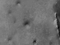
OK the CTX feature I was referring to in my last post is near the centre of the attached low-res crop, with the big depression (also dark) to the SW of it. Unfortunately I can't seem to manage to post a high-res crop, but when zoomed in it looks like a confused jumble of rocks maybe from a muliple impact.
EDIT; I look forward to that James - didn't mean to nag.
Attached thumbnail(s)
|
||
|
|
|
||
|
May 22 2010, 05:55 AM
Post
#408
|
||
 Senior Member Group: Members Posts: 2228 Joined: 1-December 04 From: Marble Falls, Texas, USA Member No.: 116 |
I wasn't sure which thread would be best to post this in. Feel free to move it.
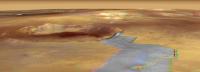
Some things I have been experimenting with recently are simulated, oblique, long-baseline anaglyphs. This first one is looking SSE from near Victoria. Opportunity's route path is yellow, with the projected, future path in blue, as per Eduardo's maps. Endeavour, Iazu, and the two large unnamed craters beyond are visible in this view. Vertical relief is exaggerated 3X to bring out some of the subtle topography along the path. It is a very wide image and will appear best on wide screens or dual monitor setups.
-------------------- ...Tom
I'm not a Space Fan, I'm a Space Exploration Enthusiast. |
|
|
|
|
|
|
May 22 2010, 06:09 AM
Post
#409
|
||
|
Senior Member Group: Members Posts: 2228 Joined: 1-December 04 From: Marble Falls, Texas, USA Member No.: 116 |
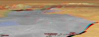
Here is one more with a better view of the future path toward Endeavour. As in the last one, the vertical exaggeration is 3X. The view is toward the SE.
-------------------- ...Tom
I'm not a Space Fan, I'm a Space Exploration Enthusiast. |
|
|
|
|
|
|
May 22 2010, 06:12 AM
Post
#410
|
|
|
Merciless Robot Group: Admin Posts: 8783 Joined: 8-December 05 From: Los Angeles Member No.: 602 |
WOW, CR!!!
 Those are incredible views, thanks! Those are incredible views, thanks!Great idea; this perspective makes a lot of difference in visualizing the route, at least for me. -------------------- A few will take this knowledge and use this power of a dream realized as a force for change, an impetus for further discovery to make less ancient dreams real.
|
|
|
|
|
May 22 2010, 07:19 AM
Post
#411
|
|
|
Forum Contributor Group: Members Posts: 1372 Joined: 8-February 04 From: North East Florida, USA. Member No.: 11 |
Very nice !
|
|
|
|
|
May 22 2010, 03:08 PM
Post
#412
|
|
|
Member Group: Members Posts: 808 Joined: 10-October 06 From: Maynard Mass USA Member No.: 1241 |
Cosmic - you rock
-------------------- CLA CLL
|
|
|
|
|
May 22 2010, 06:21 PM
Post
#413
|
|
|
Senior Member Group: Members Posts: 2998 Joined: 30-October 04 Member No.: 105 |
Neat. I think what you've done is to take a pair of GoogleMars images with Tesheiner's route overlay, in a perspective view and with vertical exaggeration, to make an anaglyph image. Good work.
I'm getting over an eye problem nowadays and can't do stereo images at all well. But from eyeballing the image here, it looks like after the Eastward Turn, the route goes over a slight rise on the way to Santa Maria (mini-Endurance). This seems to be a mismatch with Tim Parker's DEM/Topo map from 2638.pdf , which suggests a steadily decreasing slope. I may be wrong, but this has been bugging me... --Bill -------------------- |
|
|
|
|
May 22 2010, 08:04 PM
Post
#414
|
|
|
Senior Member Group: Members Posts: 3516 Joined: 4-November 05 From: North Wales Member No.: 542 |
Same thing's been bugging me. If the rise was there we wouldn't be seeing what we're seeing towards Endeavour now. We're already looking slightly down at the base of those rim hills, so there can't be anything higher in the way. I do think the perspective anaglyphs are great though.
|
|
|
|
|
May 22 2010, 08:49 PM
Post
#415
|
|
|
Senior Member Group: Members Posts: 2228 Joined: 1-December 04 From: Marble Falls, Texas, USA Member No.: 116 |
Thanks, everyone, for your kind encouragement. Bill, you're right. I did it with Google Earth/Mars.
I'm glad you guys mentioned the topography discrepancy. I had meant to explain that, but totally forgot. The method depends on the topographic model in Google Mars, which is, for the most part, MOLA. MOLA data point spacing is fairly coarse. I forget the details, but near the equator I think the sample density is on the order of 1 point per kilometer or less. Some areas, like Victoria Crater, incorporate HiRise or other DEMs which have have data points much more closely spaced. I don't recall the source of data used in Tim's map, but it was made from a more densely sampled DEM than the MOLA maps. So, until someone convinces Google to add some higher resolution elevation data to the model, we a mostly stuck with MOLA for this sort of thing. At least, this is what I think is the reason for the discrepancies. This is the same reason why parts of the rims of crater like Endeavour appear smoother than they probably are. -------------------- ...Tom
I'm not a Space Fan, I'm a Space Exploration Enthusiast. |
|
|
|
|
May 23 2010, 12:11 AM
Post
#416
|
|
|
Senior Member Group: Members Posts: 2998 Joined: 30-October 04 Member No.: 105 |
I just wanted tomake sure that I wasn't imagining a topographic discrepancy using cyclopean stereo.
But reflecting back, a couple of weeks ago Ant posted wide L1 Pancam Philo-vision panorama that suggested either a rise to the East, or level ground with a dropoff to the North and South. There may be a basis for what we're seeing. http://www.unmannedspaceflight.com/index.p...st&p=159441 That would make an interesting polar pan. I'll fiddle with it, but it may take a while since I've not done one in a long time-- if someone beats me to it, fine... --Bill -------------------- |
|
|
|
|
May 23 2010, 01:23 AM
Post
#417
|
|
|
Senior Member Group: Members Posts: 2228 Joined: 1-December 04 From: Marble Falls, Texas, USA Member No.: 116 |
I did a quick check and discovered that the Google map and Tim's map are both based on MOLA data, so I am at a loss to explain the difference. I can imagine some differences if the two maps were gridded and contoured with different conditions, but the difference we're seeing here seems beyond that. Looking at the Google data more carefully, it appears that it is not so much that there is a rise to the east, but rather that the area near where the route turns east is anomalously low. The low area is roughly the size of the area of influence of a MOLA data point, so perhaps at some time a point was deemed in error and removed from the dataset or corrected.
Tim is probably the one who can best shed light on this. -------------------- ...Tom
I'm not a Space Fan, I'm a Space Exploration Enthusiast. |
|
|
|
|
May 23 2010, 02:03 AM
Post
#418
|
|
|
Senior Member Group: Members Posts: 2998 Joined: 30-October 04 Member No.: 105 |
Gridding software is, by necessity, voodoo. Which explains it all. On Tim's contour map, there is the suggestion of a several-meter depression around Victoria, due to the elevation aperture used. Take it as the most reasonable approximation...
I think Tim uses/used ARC/INFO or an ESRI product, which is generally good but has quirks. Still better than a plane table and stadia rod... --Bill -------------------- |
|
|
|
|
May 23 2010, 07:02 AM
Post
#419
|
|
|
Senior Member Group: Members Posts: 3516 Joined: 4-November 05 From: North Wales Member No.: 542 |
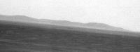
The 'horizon' in front of Endeavour is close enough that we can see individual bumps there. As we've been moving southward it should be possible to triangulate the distance to that 'horizon' quite accurately. I think this would help a lot with undersanding the lie of the land. If nobody does that I may have a go later, but others could do a much better job I'm sure.
|
|
|
|
|
May 23 2010, 08:03 AM
Post
#420
|
||
|
Senior Member Group: Members Posts: 2998 Joined: 30-October 04 Member No.: 105 |
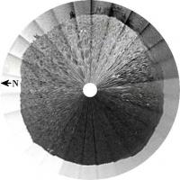
This is a quick-and dirty Polar Pan derived from Ant's rectangular pan in Post#363. I dodn't see a strong topographic high to the East as I thought I did with the rectangular pan, as much as a definite low of the near horizon to the South.
--Bill
Attached thumbnail(s)
-------------------- |
|
|
|
|
|
|

|
Lo-Fi Version | Time is now: 19th April 2024 - 11:30 AM |
|
RULES AND GUIDELINES Please read the Forum Rules and Guidelines before posting. IMAGE COPYRIGHT |
OPINIONS AND MODERATION Opinions expressed on UnmannedSpaceflight.com are those of the individual posters and do not necessarily reflect the opinions of UnmannedSpaceflight.com or The Planetary Society. The all-volunteer UnmannedSpaceflight.com moderation team is wholly independent of The Planetary Society. The Planetary Society has no influence over decisions made by the UnmannedSpaceflight.com moderators. |
SUPPORT THE FORUM Unmannedspaceflight.com is funded by the Planetary Society. Please consider supporting our work and many other projects by donating to the Society or becoming a member. |
|