Ceres Low-Altitude Mapping Orbit (LAMO) |

  |
Ceres Low-Altitude Mapping Orbit (LAMO) |
 Mar 10 2016, 09:50 PM Mar 10 2016, 09:50 PM
Post
#106
|
|
 Member  Group: Members Posts: 684 Joined: 24-July 15 Member No.: 7619 |
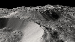
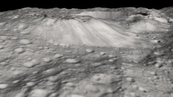
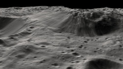
QUOTE (Gladstoner @ Mar 7 2016, 09:04 PM)  That terrain on top of Ahuna.... It just seems to have no rhyme or reason. If anything, it appears like a souffle that has risen and collapsed back down a bit (with some subsequent mass wasting around the edges). Looks like a surface that is splitting as something intrudes, raises the overlying strata, then intrudes a bit further, creating lens of material, an ice laccolith, er laccoglacius? Think Shiprock in New Mexico or Lava Butte in Nevada. Looking at the low "trail" behind the mountain, perhaps something like Hadley Rille on the moon. As to the fractured terrain on top of Ahuna Mons, it's a fictional agriculture/terraforming name, but somehow, Shai-Hulud terrain seems to fit... If you like Dune... clipped from above 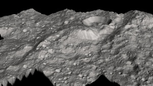
|
 |
 
|
|
Mar 10 2016, 10:21 PM
Post
#107
|
|
|
Member Group: Members Posts: 866 Joined: 15-March 05 From: Santa Cruz, CA Member No.: 196 |
|
|
|
|
|
Mar 11 2016, 04:39 AM
Post
#108
|
|
|
Senior Member Group: Members Posts: 2998 Joined: 30-October 04 Member No.: 105 |
QUOTE (HSchirmer @ Mar 10 2016, 04:50 PM) Looks like a surface that is splitting as something intrudes, raises the overlying strata, then... For sure. The closer the view, the more the mystery. In the region from Ahuna Mons up to the unnamed caldera at Liberalia Mons (LAMO-43) I see structural trends but oddly this does not carry over to the topo we have at "our" level. I'm looking forward to the papers forthcoming on these areas. https://univ.smugmug.com/Dawn-Mission/Ceres...O43%2BAhuna.png --Bill -------------------- |
|
|
|
|
Mar 11 2016, 05:39 AM
Post
#109
|
|
|
Member Group: Members Posts: 890 Joined: 18-November 08 Member No.: 4489 |
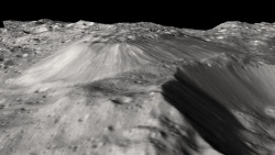
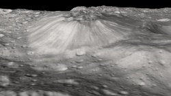
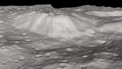
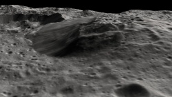
A few close-ups of the mount -- rotating around it
|
|
|
|
|
Mar 11 2016, 10:20 PM
Post
#110
|
||
 Member Group: Members Posts: 714 Joined: 3-January 08 Member No.: 3995 |
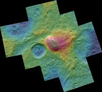
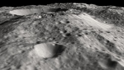
Color-coded elevation map of Ahuna Mons:
http://photojournal.jpl.nasa.gov/catalog/PIA20399
Ahuna appears to be part of a broader plateau. Is it merely the most recently formed structure in an uplift and/or eruptive complex? The adjacent upland ('Ancestral Ahuna') shows no signs of recent uplift, i.e. it may have been pummeled beyond recognition by impacts. This reminds me of one of the Hawaiian islands, with an actively erupting shield and a surrounding complex of heavily eroded extinct volcanoes (not to say these Cerean structures have similar volcanics or tectonics.... and certainly not similar erosion). Edit: Perhaps some of the other 'mons' around Ceres could be similar structures but are older and now unrecognizable. |
|
|
|
|
|
|
Mar 13 2016, 04:04 PM
Post
#111
|
|
 Member Group: Members Posts: 495 Joined: 12-February 12 Member No.: 6336 |
QUOTE (Gladstoner @ Mar 11 2016, 11:20 PM) Ahuna appears to be part of a broader plateau. Is it merely the most recently formed structure in an uplift and/or eruptive complex? Edit: Perhaps some of the other 'mons' around Ceres could be similar structures but are older and now unrecognizable. I agree, and noted the similarity to an Terrestrial uplift in the Blender-render images from JohnVV's post on March 8 - thank you JohnVV for your contribution. On Earth such "uplifts" sometime happen in areas that have had an ice age, and mountains pop up again after having been pressed down by the ice. I don't say that is the case here, and rather think it had to do with a change in mass distribution in one ridge already there but enhanced/caused by the nearby crater. This would also be the cause of the chaotic terrain on top. Even if my line of thought turn out to be wrong, I do think that Ahuna now is less of a mystery than in the early images. |
|
|
|
|
Mar 14 2016, 06:09 PM
Post
#112
|
|
|
Senior Member Group: Members Posts: 2998 Joined: 30-October 04 Member No.: 105 |
I've looked at the topography and general structure for 200km around Ahuna Mons and although I've found some anomalous highs and lows, and lineations related to the Urvara impact, I've not seen a "smoking gun" related to Ahuna Mons. I'm still going to cubbyhole Ahuna in the "Peculiar" slot.
https://univ.smugmug.com/Dawn-Mission/Ceres...cator-annot.png --Bill -------------------- |
|
|
|
|
Mar 15 2016, 01:56 PM
Post
#113
|
|
 Member Group: Members Posts: 555 Joined: 27-September 10 Member No.: 5458 |
-------------------- |
|
|
|
|
Mar 15 2016, 03:20 PM
Post
#114
|
|
|
Member Group: Members Posts: 555 Joined: 27-September 10 Member No.: 5458 |
-------------------- |
|
|
|
|
Mar 15 2016, 05:09 PM
Post
#115
|
|
 Senior Member Group: Members Posts: 3419 Joined: 9-February 04 From: Minneapolis, MN, USA Member No.: 15 |
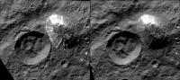
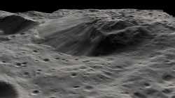
QUOTE (ZLD @ Mar 15 2016, 10:20 AM) Um, wow... that has to be one of the freshest craters we've seen in the LAMO campaign. Look at all those boulders! Um, again -- I should know this, but, what size are those boulders? A lot of them are three or more pixels wide, what's our pixel resolution from LAMO right now, on average? edit -- I asked above because I doubted this, but is it true that the "dot = 35m" at the bottom of the image really means we have 35 meter resolution? If that's the case, some of those boulders are 300 meters across, or more. -the other Doug -------------------- The trouble ain't that there is too many fools, but that the lightning ain't distributed right. -Mark Twain
|
|
|
|
|
Mar 15 2016, 06:15 PM
Post
#116
|
|
|
Member Group: Members Posts: 555 Joined: 27-September 10 Member No.: 5458 |
Yeah, that dot is the correct scale - 2 pixels is approximately 35 meters with the 200% increase in my context image.
-------------------- |
|
|
|
|
Mar 15 2016, 06:36 PM
Post
#117
|
|
|
Senior Member Group: Members Posts: 2082 Joined: 13-February 10 From: Ontario Member No.: 5221 |
It's a hallmark of that low surface gravity of 0.27 m/s; even something that massive can travel a long way...
|
|
|
|
|
Mar 15 2016, 06:49 PM
Post
#118
|
|
|
Member Group: Members Posts: 555 Joined: 27-September 10 Member No.: 5458 |
-------------------- |
|
|
|
|
Mar 15 2016, 08:32 PM
Post
#119
|
|
|
Senior Member Group: Members Posts: 3419 Joined: 9-February 04 From: Minneapolis, MN, USA Member No.: 15 |
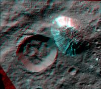
In re LAMO 45 again, not only do we see boulders up to at least 200 meters in their longest dimension, with an awful lot in the 50-meter range, the immediate ejecta blanket is extremely distinct, particularly the extraordinarily distinct edge of the ejecta blanket itself. Boulder streams are also well aligned with the patterning in the ejecta blanket. This is a wonderful example of impact cratering, actually...
 There are literally hundreds of 50- to 500-meter craters in the imaged terrain outside of the ejecta blanket, while there are less than 10 of that size (and less than half of that are 500m or more) on the imaged portion of the blanket. In fact, much of the ejecta blanket is entirely crater-free; what patches of craters that do appear in a couple of spots look like they may be patterns of secondaries from only one or two close-by impacts. We don't have an empirically derived impact flux for Ceres, but I would think a surface this crater-free would have to be awfully young, geologically speaking. Hence my enthusiasm for a very young-looking crater, here... -the other Doug -------------------- The trouble ain't that there is too many fools, but that the lightning ain't distributed right. -Mark Twain
|
|
|
|
|
Mar 15 2016, 09:32 PM
Post
#120
|
|
 Senior Member Group: Moderator Posts: 3233 Joined: 11-February 04 From: Tucson, AZ Member No.: 23 |
I wonder if that might be due to a difference in the impact flux of micrometeorites/small meteoroids compared to similar, airless surfaces we've seen at this scale, which in this size range, have all been moons. Moons would receive the typical background flux of those size objects, just as Ceres would, but there are also secondaries and sesequinaries to consider. The sesequinaries, chunks of material blasted out from other moons in the system or from the same moon but which take a longer path to come back than just a simple ballistic one, might be making relatively fresh craters in the outer solar system and the Moon look older than they otherwise would.
-------------------- &@^^!% Jim! I'm a geologist, not a physicist!
The Gish Bar Times - A Blog all about Jupiter's Moon Io |
|
|
|
|

|
Lo-Fi Version | Time is now: 25th April 2024 - 08:09 AM |
|
RULES AND GUIDELINES Please read the Forum Rules and Guidelines before posting. IMAGE COPYRIGHT |
OPINIONS AND MODERATION Opinions expressed on UnmannedSpaceflight.com are those of the individual posters and do not necessarily reflect the opinions of UnmannedSpaceflight.com or The Planetary Society. The all-volunteer UnmannedSpaceflight.com moderation team is wholly independent of The Planetary Society. The Planetary Society has no influence over decisions made by the UnmannedSpaceflight.com moderators. |
SUPPORT THE FORUM Unmannedspaceflight.com is funded by the Planetary Society. Please consider supporting our work and many other projects by donating to the Society or becoming a member. |
|