Printable Version of Topic
Click here to view this topic in its original format
Unmanned Spaceflight.com _ Tianwen 1- 2020 Orbiter/Lander _ Tianwen-1 At Mars
Posted by: Greenish Feb 8 2021, 03:04 PM
For those who haven't already seen, there is excellent work independently tracking and predicting the trajectory of Tianwen-1 by radio amateurs (using that word only technically, since they are very much pros).
The latest is predicting orbital insertion at 8 seconds before 1200 UTC on Wednesday 10 February, with a 386 km periapsis - burn starts a few minutes before that if you, like me, are planning your peanut consumption carefully this week.
Plenty of details to be found at these links (even a GMAT script and Jupyter notebook, and some doppler data, for the astrodynamically inclined).
https://destevez.net/tag/tianwen/
https://twitter.com/ea4gpz/status/1358727059569324033
https://twitter.com/coastal8049/status/1358173866678444032
Posted by: Huguet Feb 10 2021, 01:26 PM
Daniel Estévez (Twitter)
@ea4gpz
"Acqusition of signal confirmed in @SternwarteBO shortly after 12:48 UTC. The spacecraft is still using the low gain antenna."
https://twitter.com/ea4gpz/status/1359484672456196097
https://spacenews.com/chinas-tianwen-1-enters-orbit-around-mars/
Tianwen-1 in orbit of Mars,... we should receive some photo,.. some time... i think...
...anxious to see some of the best then 50cm resolution images it will take in the near future...

|
Posted by: Greenish Feb 10 2021, 01:38 PM
Orbital insertion confirmed. CASC says landing attempt May-June timeframe now, per https://twitter.com/aj_fi/status/1359491977931292674?s=21.
Posted by: MERovingian Feb 10 2021, 02:05 PM
And another one! Mars is a spoiled planet!  What a great couple of days it has been!
Congrats to the Chinese space agency, 6th to the red planet!
Posted by: Huguet Feb 10 2021, 04:27 PM
Interesting is the enormous numbers of firsts for the chinese in this mission,.. and the number of technologies they are using that are well tested on the chang's missions.
1 - Arriving Mars
2 - Orbiting Mars
3 - Mars close approach and High Resolution Image Mapping
4 - Mars Landing
5 - Mars Rover
The only achievment that will not be reached is Mars Return and Taikonauts to Mars.... and the first one they already proved at 1.6m/s2 moon gravity... big step to prove on mars 3.7m/s2 gravity... the second task,.. well, lets wait till they make it on Moon...
Posted by: nprev Feb 10 2021, 04:45 PM
This will be the general thread for orbital operations. A new thread will be established for landing and surface activities once those occur.
Posted by: Huguet Feb 11 2021, 09:52 AM
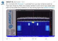
"At ~13:14:20 UTC #Tianwen-1 switched from Low Gain Antenna (LGA) to High Gain Antenna (HGA) and already started to send some high speed data back to the CSNA Groundstations."
Anyone to decode that?...
@AMSATDL AMSAT-DL ON TIANWEN-1
https://twitter.com/amsatdl/status/1359643118782578690
21 May predicted date to land on Mars:
@PRCMarsRover
https://twitter.com/PRCMarsRover/status/1359834987277684740
|

|
Posted by: Steve G Feb 11 2021, 12:58 PM
Hopefully, they might be able to get a peek at neglected Deimos.
Posted by: neo56 Feb 12 2021, 11:10 AM
https://twitter.com/AJ_FI/status/1360147974282743809?s=20
https://twitter.com/AJ_FI/status/1360149027342458881?s=20
Posted by: Huguet Feb 12 2021, 12:21 PM
Congrats CASC,... continue sending every raw footage or data yu receive from Tianwen-1, never too much... I have worked with the Yutu-2 Data and must say that if we got the same from Tianwen-1 it will be stupendous...
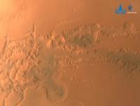
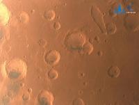
Posted by: neo56 Feb 12 2021, 09:27 PM
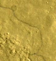
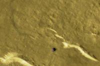
I did some quick image processing on screenshots of Tianwen-1 video of Mars orbit insertion to enhance surface features.
https://flic.kr/p/2kB7SAY
https://flic.kr/p/2kB8FF5
https://flic.kr/p/2kB4B5f
https://flic.kr/p/2kB882X
Posted by: Antdoghalo Feb 12 2021, 10:30 PM
Congrats to the Chinese for being number 6 to enter orbit!!!
Looks like it photographed Albor Tholus and Elysium Chasma.
Posted by: Huguet Feb 12 2021, 11:07 PM
Wonderfull views of Mars overlapped by tianwen-1, one idea, CASC should release another drop cam to get a far image of Tianwen-1 with Mars at the background...
Posted by: rlorenz Feb 12 2021, 11:53 PM

https://twitter.com/AJ_FI/status/1360149027342458881?s=20
Very cool !
I'm surprised at the amount of foreground movement in the solar array movie (circa 45s). Not quite sure what is going on - array flexing? And if it is a structural oscillation or some controlled movement (gimballing of something, it almost looks like something is stepping or limit-cycling)
Posted by: fredk Feb 13 2021, 12:22 AM
I couldn't see anywhere by what factor those clips are sped up...
Posted by: Ron Hobbs Feb 14 2021, 04:54 PM
Planetary Society's Tianwen-1 page has it on Vimeo. Here is the info:
TIANWEN-1 ENTERS MARS ORBIT This video shows China's Tianwen-1 orbiter and rover entering Mars orbit on 10 February 2021. The spacecraft captured the images 3 seconds apart, and the entire video covers a period of 27 minutes. Video: CNSA/PEC via Andrew Jones
Posted by: Quetzalcoatl Feb 15 2021, 06:58 PM
Hello everybody,
Tianwen-1 was now to perform a manoeuvre to move from its equatorial insertion orbit to a polar orbit with the objective of establishing a map of the Martian surface that will be used for the selection of the landing site.
https://twitter.com/guo_linli/status/1361114922277425153
TianWen-1 successfully carried out this maneuver :
https://twitter.com/guo_linli/status/1361277655069327364
Posted by: Steve5304 Feb 18 2021, 09:26 PM
Tianwen-1 was now to perform a manoeuvre to move from its equatorial insertion orbit to a polar orbit with the objective of establishing a map of the Martian surface that will be used for the selection of the landing site.
https://twitter.com/guo_linli/status/1361114922277425153
TianWen-1 successfully carried out this maneuver
:https://twitter.com/guo_linli/status/1361277655069327364
This is really cool.
Im so excited to see where China decides to put the lander down
Posted by: kenny Mar 2 2021, 09:45 AM
Tianwen-1's orbit has been adjusted further. The South China Morning Post reports that on Wednesday February 24, two weeks after initial orbit insertion, Tianwen-1 entered what they described as "its parking orbit", quoting the space agency CNSA.
"Each complete orbit will take Tianwen, or Heavenly Questions, two Martian days or slightly longer than two days on Earth with the lowest and highest points being 280km (174 miles) and 59,000km above the planets surface.
During its time in orbit, Tianwen-1 will use its cameras and spectrometer to carry out a detailed investigation of the Martian landscape and weather at its intended landing site before a planned touchdown in May.
Currently the status of equipment is normal and all flight control systems are working as planned, CNSA said.
It also acknowledged Perseverance's successful landing at Jezero Crater.
https://www.scmp.com/news/china/science/article/3122966/china-space-programme-tianwen-1-enters-mars-parking-orbit-ahead
Posted by: SulliedGoon Mar 2 2021, 11:09 AM
Will we see orbital pictures from NASA of
the eventual landing or does the
ban on cooperation extend to even passive
activities such as imaging from orbit?
Posted by: Hungry4info Mar 2 2021, 12:46 PM
LRO has imaged each of the landed Chang'e missions, so presumably MRO can image the Tianwen-1 lander.
Posted by: mcaplinger Mar 2 2021, 04:08 PM
I don't know if it applied to LROC imaging, but there needed to be congressional approval for at least some LRO support. See https://www.scientificamerican.com/article/farside-politics-the-west-eyes-moon-cooperation-with-china/
Posted by: Hungry4info Mar 4 2021, 02:16 AM
From https://weibo.com/5386897742/K4AVS2zt8?ssl_rnd=1614823973.9627&type=comment#_rnd1614824040705

|
|
|
Posted by: Explorer1 Mar 4 2021, 02:43 AM
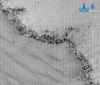
Is the low sun angle why the polar cap isn't bright white like we see in other images (both Hubble and other orbiters?) Or are others "enhanced" and this one is not?
Posted by: mcaplinger Mar 4 2021, 05:59 AM
Pretty typical for this season. See https://apod.nasa.gov/apod/ap980924.html for example.
Posted by: Phil Stooke Mar 4 2021, 07:44 AM
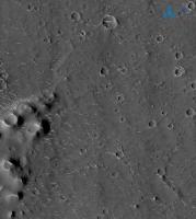
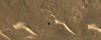
The high resolution image with the small cones on the left edge is at 24.74 N, 110.17 E. I have not found the other location yet. This is right on a candidate site.
CTX image: CTX-J05_046929_2048_XN_24N250W
|
Phil
Posted by: Quetzalcoatl Mar 4 2021, 08:47 AM
the eventual landing or does the
ban on cooperation extend to even passive
activities such as imaging from orbit?
Hello,
I don't think the ban on cooperation extends also to innocent espionage activities.
Posted by: mcaplinger Mar 4 2021, 04:16 PM
Not sure what point you're trying to make. To image during the landing, the MRO team would have to know the time and place weeks or months in advance, adjust the spacecraft's orbit, and plan the images. If CNSA doesn't make that information public on that timescale, it's not happening. Post-landing imaging might be easier if there was some information about where to look.
Posted by: JRehling Mar 4 2021, 05:04 PM
To add a bit more detail, during a long winter night, a martian polar cap accumulates CO2 ice. Meanwhile, the other hemisphere is in summer, and warm and kicking up dust clouds. As atmospheric dust settles, it creates a thin layer of dust over the otherwise white polar ice of the winter cap. Southern summer is now over and we're seeing the northern cap for the first time in months. Next, the "spider" phenomenon will begin wherein sublimating CO2 ice will pop small holes in the dusty cover. Eventually, the CO2 will be gone and there'll be a dirty H2O ice cap at minimum size. And when that goes through martian autumn, new CO2 ice (and H2O frost) will make the cap grow big and white.
Posted by: Quetzalcoatl Mar 15 2021, 06:04 PM
Of course.

I have never said that we could see such images but simply that a cooperation ban is completely foreign to that.
Posted by: Huguet Mar 26 2021, 11:23 AM
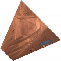
New Photos from medium-res camera. Detail of mars tiny limb.
https://mobile.twitter.com/AJ_FI/status/1375401463682306051

|

|

|
Posted by: kymani76 Apr 4 2021, 10:59 AM
|
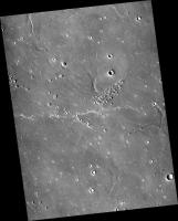
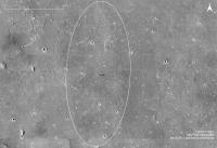
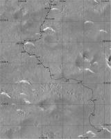
Map of Tianwen-1 landing site in Utopia Planitia based on coordinates published in an article by Andrew Jones.
Landing ellipse is 100x40 km, ellipse azimuth orientation estimated from orbiter's orbital inclination of 87.7 degrees.
Posted by: kymani76 Apr 4 2021, 11:01 AM
|
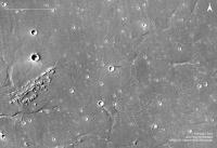
A close-up of the central area.
Once the mapping thread for the mission is established the maps can be moved there.
Posted by: Phil Stooke Apr 4 2021, 09:37 PM
Very nice maps! Once we are safely down I will start a map thread and these can be the first posts.
Phil
Posted by: Art Martin Apr 5 2021, 03:40 AM
|
|
A close-up of the central area.
Once the mapping thread for the mission is established the maps can be moved there.
Wow, that's a gutsy first landing given how tough it is just to set down safely on a Martian surface with almost no obstacles and they are aiming for a spot adjacent to a rather scary looking crater. Wouldn't take much during that 7 minutes or so of "terror" timing to be off by a significant amount. I wonder how much hover and maneuver time they have built into the lander to be able to spot and avoid large obstacles at the last minute.
Posted by: Antdoghalo Apr 5 2021, 10:27 AM
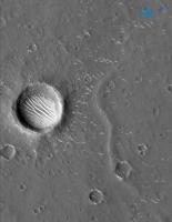
There are also a lot of pseudocones and lava wrinkles/channels in the landing ellipse too.
Posted by: john_s Apr 5 2021, 02:56 PM
Given the size of the landing ellipse, there's very little chance of landing next to that crater right in the center of the ellipse. I suspect it's just coincidence that the ellipse center is on the rim of that crater.
John
Posted by: djellison Apr 5 2021, 03:18 PM
Yeah - the landing ellipse is almost certainly larger than that entire image.
Posted by: kymani76 Apr 5 2021, 08:46 PM
I guess there are many uncertainties, but this map is a start, based on limited data available.
Landing ellipse could certainly be bigger, I got 100x40 km from Twitter source, so far from 100% reliable. Couldn't find this information
in any Chinese source to confirm it's really true. The landing coordinates precision (24,748N, 110,318E) by itself carries about 100 meters imprecision in any direction.
CTX camera images are also not absolutely referenced, although I did check different images to confirm that the coordinates really work out to be at crater's rim.
On the other hand the two high resolution images published so far do show area at the center of the map, so they could be working towards landing near the center of the ellipse.
And thank you Phil. It is always nice to get encouraged by the best.
Posted by: kenny Apr 19 2021, 04:45 PM
Apollo 12 in 1969 was trying to land close to the dead Surveyor 3 craft, which was located inside a sizeable lunar crater with internal slopes which could not be landed on safely. So the Commander asked the navigation team to target him directly at Surveyor, on the basis that, due to landing errors, this was the best way to AVOID hitting Surveyor or descending inside its crater! The same rationale might apply here -- aim for the place that you least want to arrive at, in the sure knowledge that actually getting there is extremely unlikely!
Posted by: kenny Apr 19 2021, 07:07 PM
Apollo 12 in 1969 was trying to land close to the dead Surveyor 3 craft, which was located inside a sizeable crater with internal slopes which could not be landed on safely. So the commander asked the navigation team to targeted him directly at Surveyor, on the basis that, due to landing errors, this was the best way to AVOID hitting Surveyor or decending inside its crater! The same rationale might apply here -- aim for the place that you least want to arrive at, in the sure knowledge that actually getting there is extremely ulikely!
Posted by: tdemko Apr 20 2021, 07:32 PM
This phenomena played a role in the plot of the novel Gravitys Rainbow by Thomas Pynchon, wherein the German V-2 engineers would observe the impacts of ballistic rocket tests from the center of the targeted bullseye.
Posted by: Huguet May 10 2021, 02:31 PM
We are entering the week distance window of the estimated landing date (17/may), from 10/may till 24/may.
As expected no info, but if they continue with the estimated dates, soon they will try the landing.
https://www.uol.com.br/splash/noticias/afp/2021/05/10/agenda-internacional-afp-7-dias.htm
AFP international news for 7 days, land probably before May 15.
"China's Tianwen-1 mission getting set to try and land Zhurong rover on Mars"
https://www.abc.net.au/news/science/2021-05-12/mars-china-tianwen-1-mission-zhurong-rover-landing/100101552
Posted by: tolis May 12 2021, 10:11 AM
I don't think the entry module will be "detaching from an orbiter 70 kilometres above the surface", that's already in the atmosphere!
Instead it would be detaching from the orbiter somewhere along the orbit, the question is then how to change the entry module orbit to
intersect the atmosphere. For Viking, the entry module carried its own propulsion system for this purpose.
Posted by: Huguet May 12 2021, 10:33 AM
Indeed not less than 200km at periapsis. Timing for Zhurong to start its landing maneuver, in UTC, by Edgar Kaiser, based on the orbiter periapsis and time over the landing guessed coordinates on Utopia Planitia:
Mars in sight over China
2021.05.10 20:33:02 SKIPPED
2021.05.12 21:47:53 SKIPPED
Mars off sight over China
2021.05.14 23:02:44 DATE OF LANDING, BY SOURCE QUOTING CAST (by Cosmic_Penguin)
2021.05.17 00:17:35
2021.05.19 01:32:26
Mars in sight over China
2021.05.21 02:47:17 In sight with Jiamusi Antenna: https://en.wikipedia.org/wiki/Chinese_Deep_Space_Network
2021.05.23 04:02:08
2021.05.25 05:16:59
Last periapsis on May:
27/05/2021 06:31
29/05/2021 07:46
Date of Landing, by a source quoting CAST:
https://twitter.com/Cosmic_Penguin/status/1392701561030123521
More from Edgar Kaiser, that sugests we could have an atempt at today window: "Tianwen-1 showed quite some ground station activity along yesterday's approach to apoapsis. Tonight, at 21:47:53 UTC it will pass periapsis again."
Based on Mars position in the sky on the periapsis dates, chinese would have best comunication with the Tianwe-1 only today, bad sight on 14, 17 and 19th, so it apears that today could be the last window till may 21th.
https://twitter.com/df2mz/status/1392384013986410504
Orbital Period is 49h 14m 51s
https://twitter.com/df2mz/status/1391876766294331395
Good Thread following the landing from kaynouky
https://twitter.com/Kaynouky/status/1392051005664239619
Posted by: Huguet May 13 2021, 10:03 AM
Finally a date, not direct from CAST, but by a source quoting CAST's chief adviser of Interplanetary Exploration:
Landing on May 14, 23:11 UTC, 40 hours from now.
https://twitter.com/Cosmic_Penguin/status/1392701561030123521

|
Posted by: Huguet May 13 2021, 11:43 AM
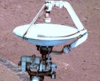
The Zhurong will use the same navigation technology used on Chang'e-4, based on rotating stereo pair of câmeras. May have some changes, but the same methods used on one batch of data will deal with the other.

|
Posted by: Huguet May 13 2021, 11:49 AM
"Communication before (land) would be handled by Zapala ground station in Argentina." Edgar Kaiser
https://twitter.com/df2mz/status/1392764250481991681
After the landing the initial data will be passed to the Jiagmusi antenna, so problaby we will have some images on saturday.
https://twitter.com/df2mz/status/1392787065797062656
NFT on 1o photo by 15 from a Yangzhou company...
https://twitter.com/MarsZhurong/status/1392718169006030848

|
Posted by: Nordren May 13 2021, 01:23 PM
Protected by a cone-shaped heat shield, it will hurtle towards the surface at supersonic speeds before deploying a giant parachute to slow it down.
This GIANT Parachute got me... how giant will it be...
Curious. I don't recall telling ABC anything about altitude of separation, and certainly wouldn't have said that. Oh well!
Posted by: Huguet May 13 2021, 01:31 PM
I Believe the only real citation are beetween quotation marks... The problem with journalism, they insert a lot they get from all over the net beetween this quotes... My bad, i put quotes in all the text from the link. Removed it. Nice to see you here!
Posted by: Nordren May 13 2021, 01:48 PM
No worries and thanks for the greeting! A welcome change from being haunted by my own mistakes! Great community here too.
Posted by: stevesliva May 13 2021, 03:15 PM
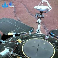
What are the circular patches on the back of the rover? There must be some reason they don't have solar cells on them.
I wonder how much artistic license there is in that image, or will even the camera calibration target look so familiar...
Posted by: Huguet May 13 2021, 03:23 PM
This is the best photo i have seen from the Zhurong. I have been alerted that these are thermal windows,.. so.. i don't know.
|
|
Posted by: ollopa May 13 2021, 11:13 PM
https://twitter.com/MarsZhurong/status/1392718169006030848
English is my first language, but this literally does not make any sense. "Tokenized"? NFT? And who are Fude Sports, apparently "the copyright owner of the photo"? The whole thing sounds ridiculous - unless someone here sees something I don't?
Posted by: Phil Stooke May 13 2021, 11:54 PM
Non-Fungible Token - I can't explain it other than saying look it up as I just had to do (not trying to be rude, I just can't explain it). The post seems to imply that China has sold the rights to the first image to some entity or other. I find it hard to believe. But as we know the whole world has gone crazy.
Phil
Posted by: Hungry4info May 14 2021, 12:50 AM
Think of NFT's like ownership rights of artwork. Someone might privately own a famous painting, giving them the right to say "hey I own that, that's mine," even if that doesn't give them the right or ability to control how the image of that art is used. We can all use, modify and post images of, for example, the Mona Lisa, without fear of copyright infringement. It's "non-fungeable," because of course it can't be thought of as a common medium of exchange (like normal currencies). Generally, therefore, one can usually be safe transferring over what they think of the art market over to NFTs. That being said, the whole concept is an application of blockchain technology to keep a secure record of ownership, so it might be part of an emerging field of secure commodity exchange - imagine every commodity having a "seal of authenticity." It might also be just the latest blockchain-related fad. I don't really know.
Posted by: nprev May 14 2021, 05:07 AM
Based on the Twitter feed linked to by Huguet, it appears that the rover is named Zhurong and that there will be a landing attempt 14 May/2300 UTC, approximately 19 hrs from this post. Accordingly, http://www.unmannedspaceflight.com/index.php?showtopic=8627.
Posted by: Steve5304 May 15 2021, 02:33 AM
Phil
I trade Crypto
Its an image sold off like as a Crypto currency. Its a rare digital asset and yes it is real...the NFT crypto market is over 100 million USD
so in essence, its a blockchain painting
Posted by: marsophile May 15 2021, 02:48 AM
Landed Successfully!
https://spaceflightnow.com/2021/05/15/china-lands-its-first-probe-on-mars/
Posted by: Steve5304 May 15 2021, 04:30 AM
I cant find much information on the instrument loadout of the Zhurong rover but it appears to be packed with instruments. Does anybody have a rundown on what CNSA is trying to study here? Or is it more of a technology demonstrator?
Posted by: marsophile May 15 2021, 06:14 AM
Some information here:
https://spacenews.com/chinas-zhurong-mars-rover-lands-safely-in-utopia-planitia/
It mentions 6 science payloads.
Posted by: nogal May 15 2021, 05:37 PM
Here is a somewhat detailed https://www.must.edu.mo/en/news/33991-article07232155-e from the State Key Laboratory of Lunar and Planetary Sciences, M.U.S.T./ Macau Space Exploration and Science Center of the National Space Administration.
The Wikipedia https://en.wikipedia.org/wiki/Tianwen-1 is also worth reading.
Fernando
Posted by: Hungry4info Jan 1 2022, 01:04 AM
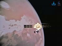
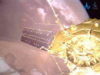
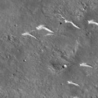
Wow! Tianwen-1 observed from a deployed sub-satellite.
https://mp.weixin.qq.com/s/hUJHZD10VONAulzIXnfFtA
|
|

|
Posted by: Phil Stooke Jan 1 2022, 02:30 AM
Very cool indeed! The website linked to by Andrew Jones here:
https://twitter.com/AJ_FI/status/1477077043435163650
(same one Hungry4info linked to) also has a surface image from Zhurong, and says the rover has driven 1400 m in 225 days (I assume that means sols).
Phil
Posted by: Huguet Jan 1 2022, 01:45 PM
That's the third deployable camera of the mission (2 on orbiter, 1 on rover) I really liked this feature, but i believed the deployable camera on the rover should be reusable..
Posted by: Paolo Mar 12 2022, 09:12 AM
the Chinese journal Scientia Sinica Technologica has a lot of papers on TW-1 and Zhurong in its latest issue (unfortunately, most if not all papers are in Chinese)
https://www.sciengine.com/publisher/scp/journal/SST/52/2?slug=browse
Posted by: vikingmars Mar 13 2022, 06:02 AM
https://www.sciengine.com/publisher/scp/journal/SST/52/2?slug=browse
Thank you very much Paolo : it's very interesting indeed
Posted by: Phil Stooke Mar 18 2022, 10:55 PM
https://twitter.com/AJ_FI/status/1504905964817981440
Andrew Jones tweets news of a HiRISE image only a week old!
Phil
Posted by: Phil Stooke Mar 18 2022, 11:01 PM
Two details, enlarged and contrast-enhanced. I will use this to update my map.
Phil
|
|
Posted by: Bill Harris Mar 20 2022, 06:10 AM
That whole HiRISE section is amazing. I look forward to the on-ground view of that "ejecta scar".
-Bill
Posted by: Huguet Mar 22 2022, 10:38 AM
Andrew Jones tweets news of a HiRISE image only a week old! Phil
Image taken 11/march... freshly...
https://www.uahirise.org/ESP_073225_2055
|
Posted by: Huguet Mar 22 2022, 03:10 PM
Interesting comparation beetween Hirise from June/2021 and March/2022 on the tracks, to see how the dust act on then...
|
|
|
Posted by: vikingmars Mar 23 2022, 12:18 PM
Thank you very much Huguet for those nice processings of yours
Posted by: Phil Stooke Mar 24 2022, 07:16 AM
Check out this article:
https://news.sina.com.cn/c/2022-03-24/doc-imcwipii0221404.shtml
Images of Zhurong from orbit recently, plus orbital views and even an image of Perseverance during its last sampling operation near the landing site.
Phil
Posted by: vikingmars Mar 24 2022, 10:37 AM
Phil
Thank you very much Phil for the link !
This Chinese publication was anticipated since a new HiRISE image was published

Posted by: Huguet Mar 24 2022, 11:15 AM
You are welcome. It is visible the action of the dust in the white jet fuel surrounding the lander. On the tracks we can see little action, most the tracks are still the same 1 year latter.
I was missing new Zhurong pictures.
Here follows a processing of the released one showed on Phil link. The dust appears to be acting more at the transmitter mast.
|
|
|
|
Posted by: Phil Stooke Mar 29 2022, 11:48 PM
This open-access paper:
https://mdpi-res.com/d_attachment/remotesensing/remotesensing-14-00709/article_deploy/remotesensing-14-00709-v2.pdf
describes the descent imaging used by the TW-1 lander for hazard avoidance and localization.
Phil
Posted by: Bill Harris Mar 30 2022, 01:29 AM
Nice images, Huguet. I wonder why the ground along the vented fuel shows as a white color. My initial view of it was in black.and white, so I assumed it was a lighter tone of the Martian ochre. The white surprises me.
And I be interested in seeing the dust accumulation on the solar panels.
--Bill
Posted by: Huguet Mar 31 2022, 04:57 PM
I will do some more comparations. Here follow the parachute beetween almost 1 year of exposure.
|
Posted by: Phil Stooke May 6 2022, 06:56 PM
An update tweeted by Andrew Jones:
https://twitter.com/AJ_FI/status/1522461426010443776
and the link it contains:
https://mp.weixin.qq.com/s/upO6NTh-AZ7oNLjv0BmNdw
Two orbiter images and a new view of a crater with rocks on its rim.
Phil
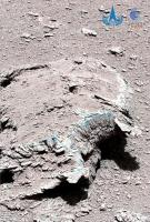
Posted by: Phil Stooke May 6 2022, 07:31 PM
This is the new surface image roughly projected for perspective"
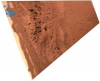
|
And the location in the latest HiRISE image with the surface image field of view approximately mapped. The rover is visible at the upper edge.
|
Phil
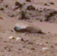
Posted by: Huguet May 10 2022, 01:56 PM
Thanks Phil.
Appears to me that the stones has changed a lot since the first ones...
|
|
|
|
Posted by: Phil Stooke May 10 2022, 05:21 PM
The early rock might have been weathered on the surface for a hundred million years. The later rock looks like it was recently excavated by a small impact, so much less weathered. But we need a better image of the new rock!
Phil
Posted by: Hungry4info Jun 20 2022, 03:21 PM
Sun Zezhou, chief designer of Tianwen-1, delivered https://www.koushare.com/lives/room/812404 about China's Mars exploration goals. In it, it was mentioned that Tianwen-1 will test aerobraking at Mars to lower its orbit to gain some experience for this ahead of the future Tianwen-3 mission. Presumably this means the orbital period and thus the regularity with which it can act as a relay for Zhurong will change, but I haven't seen anything about that so far.
Posted by: Phil Stooke Jun 26 2022, 07:30 AM
Here is a good open access paper on rover mapping:
http://scis.scichina.com/en/2022/172201.pdf
Phil
Posted by: vikingmars Jun 27 2022, 07:11 PM
Phil
Thank you very much Phil for this useful link
Posted by: Hungry4info Jun 29 2022, 12:06 PM
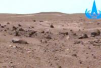
Some new images from Tianwen-1.
|
|
|

|
|
Posted by: Phil Stooke Jun 29 2022, 07:45 PM
This tweet from Andrew Jones shows a surface image from the same original Chinese source as those orbiter views:
https://twitter.com/AJ_FI/status/1542045651101442049
Here is the image in a rough perspective view:
|
I believe it was taken at the last point on this map, approx. sol 300 of the mission:
|
A Tianwen-1 orbiter image of the rover at that location was also released earlier - showing tracks and the rover (also in post #74 above):
https://news.sina.com.cn/c/2022-03-24/doc-imcwipii0221404.shtml
(The orbiter image is one of those on that site)
The map I posted here does not show the more recent drives and the current location at the hibernation point. That will follow.
Phil
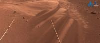
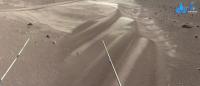
Posted by: Huguet Jul 1 2022, 09:26 AM
Hello Phil, Here follows the original link: http://www.chinanews.com.cn/gn/2022/06-29/9791303.shtml
I Attached the original image and a processed one.
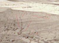
I believe these lines at the dune are new for me. It would be nice if Zhurong get some closes of then, to understand how they are forming.
Apears to be related with these black spots, mabe some light material pushed by wind, creating random patterns.
|
|

|
|
Posted by: Bill Harris Jul 1 2022, 12:02 PM
Interesting! Rather a miniature version of the Walking Rocks at Death Valley. Possibly wind-moved rocks among saltating sand grains?
Maybe we can get Ralph Lorenz on the case?
#ralphlorenz
--Bill
Posted by: serpens Jul 2 2022, 09:43 AM
To me it looks like erosion of an armored dune, or more like a large ripple; effectively a blowout. As erosion progressed, armoring pebbles rolled down the slope
Posted by: rlorenz Jul 2 2022, 01:51 PM
Yes, I'm inclined to agree. Very interesting locale! There are aspects that remind me of the yardangs in the Argentine Puna (where there are also gravel ripples) but I dont think I've seen rock tracks like this on a ripple.
It doesnt look like there is a lot of slope to drive motion, so presumably the rolling pebbles are wind-driven (or just possibly they roll when wind undercuts the sand from underneath). But if the sand can move, how are the trails preserved ? I dont doubt some modeler could come up with a scenario, but it would take a bit of fine-tuning for sand to be scoured in the lee of a pebble but not elsewhere...
It definitely looks like an armored dune overall, maybe an ejecta layer from a nearby impact covered the dune, immobilizing it, and then as you say, once the wind gets in it undercuts and blows out parts
Ralph
Posted by: Bill Harris Jul 8 2022, 06:09 PM
Likely explanation, rlorenz. The Racetrack playa was a humorous stretch prompted by the low slope of this area. Clearly this is a wind-driven process, but how are sub-centimeter, millimeter-sized pebbles leaving such well defined trails?
Mars never ceases to amaze.
--Bill
Posted by: Phil Stooke Jul 8 2022, 07:27 PM
How about an alternative to the wind? A crater forms some distance away, ejecting a block which impacts at low velocity near this location, making a secondary crater. The low velocity of the secondary crater's own ejecta results in a spray of small fragments which fall on the surface, having enough momentum to roll or skid along the surface briefly to create the observed effect. Finer material in that little ejecta cloud is slowed by the atmosphere and falls elsewhere. If this sounds a bit ad hoc, fair enough, but this process must occur frequently all over Mars. Think of just throwing a handful of gravel over the ground and what that would look like.
Phil
Posted by: Huguet Jul 8 2022, 11:01 PM
One thing for shure....
Zhurong Team from casc/csna... where are the close pictures of these moving material? .... we would love to see it...
Posted by: Hungry4info Jul 9 2022, 12:33 AM
This is the thread for the orbiter, isn't it? Perhaps some of these posts should go to http://www.unmannedspaceflight.com/index.php?showtopic=8627.
Posted by: nprev Jul 9 2022, 08:27 AM
ADMIN MODE: Noted. The discussion here evolved a bit from landforms observed from orbit to same observed by the rover, but if the focus remains on the latter & these apparent 'roving pebbles' then it'll be moved over to the Zhurong thread. Fascinating stuff regardless.
Posted by: Hungry4info Jul 23 2022, 05:24 AM
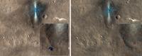
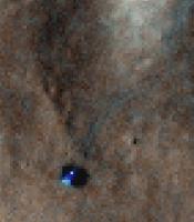
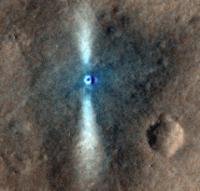
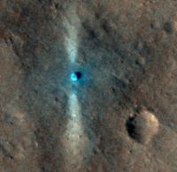
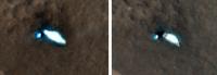
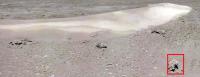
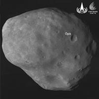
Tianwen-1 has snapped a pic of Phobos.
(source https://mp.weixin.qq.com/s/ziktrq8LcH-g065k3TcYRQ)
|
Posted by: Phil Stooke Mar 5 2023, 08:31 AM
http://jdse.bit.edu.cn/sktcxb/cn/article/doi/10.15982/j.issn.2096-9287.2023.
This is a link to China's Journal of Deep Space Exploration, and a notice of a forthcoming paper on Phobos observations by the TW-1 orbiter. There is an English language summary with interesting details. It will probably be another 3 or 4 months before the actual paper is released. More observations than the one shown above have already been made.
summary:
-----------------------------------
Orbit Design and Analysis of the Phobos Close Approach Exploration Mission for Tianwen-1 Mars Orbiter
ZHENG Huixin1, 2 , , XIE Pan1, 2 , , Li Haiyang1, 2 , ZHU Xinbo1, 2
1. Shanghai Institute of Satellite Engineering, Shanghai 201109, China
2. Shanghai Key Laboratory of Deep Space Exploration Technology, Shanghai 201109, China
Abstract: In this paper, the mission orbit design and analysis of a potential extended mission, Phobos close approach exploration, is carried out. The state at the end of the main mission is used as the input of the extended mission in this paper. Through analysis, it is concluded that Mars perturbation force can be used to adjust the argument of perigee, and the intersection frequency is related to the value of semi-major axis and eccentricity. Orbit descent maneuver should be performed to increase the number of intersections. As a result, the possibility of conducting aerobraking in order to reduce fuel consumption is analyzed. Finally, phase adjustment maneuver is calculated to complete the Phobos Close Approach Exploration Mission. The orbit design results and the velocity increment are given by simulation. The results of this paper can provide reference for the orbit design of Tianwen-1 orbiter extended missions.
Key words: Phobos close approach exploration / Orbit design / Tianwen-1 Mars Orbiter
Highlights
- Under the condition that the remaining fuel of Tianwen-1 Mars Orbiter is considerably limited and the Orbiter cannot be directly transferred to the orbit of Phobos, this paper utilized Mars perturbation force in adjusting the argument of perigee to make the orbit of the orbiter intersect with the orbit of Phobos.
- The intersecting frequency between the orbit of Tianwen-1 Mars Orbiter and Phobos is related to the value of semi-major axis and eccentricity. The intersecting frequency can be maximized by designing appropriate orbital parameters.
- In order to complete the close approach detection of Phobos, the Orbiter has to maneuver from the remote sensing orbit to the extended mission orbit. The Mars aerobraking is adopted as the orbital descent maneuver strategy, which can reduce fuel consumption by 80%.
- By designing an appropriate phase adjustment orbit period, the phase adjustment velocity increment can be controlled within 10m/s under the worst conditions of approach detection phase.
-----------------------------------
Phil
Posted by: Phil Stooke Mar 6 2023, 08:37 AM
Guo, X., Yan, J.G., Yang, X., Liu, L., Chen, Y.H., Ye, M. and Barriot, J.P., 2023. Simulation of Phobos gravity field estimation from Tianwen-1 flybys and implications for the modeling of Phobos internal structure. Monthly Notices of the Royal Astronomical Society.
This citation is to a paper on Phobos flybys. It deals with simulations but again shows considerable interest in the exploration of Phobos.
Phil
Posted by: Phil Stooke Apr 24 2023, 07:21 AM
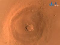
https://twitter.com/CNSAWatcher/status/1650374776534474754
This tweet has links to a nice Tianwen-1 global Mars map in several different projections.
Phil
Posted by: kymani76 Apr 24 2023, 08:28 PM

|
Some synthetic views from low resolution version of TW1 map, with poles visible.
Posted by: Phil Stooke Jul 11 2023, 03:34 AM
Orbiter selfie apparently taken by a deployable camera:
https://twitter.com/AJ_FI/status/1678438370291113986
Phil
Powered by Invision Power Board (http://www.invisionboard.com)
© Invision Power Services (http://www.invisionpower.com)