
New Olympus Mons image, 6 km high scarp |

New Olympus Mons image, 6 km high scarp |
 Mar 3 2006, 03:16 PM Mar 3 2006, 03:16 PM
Post
#1
|
|
 Member  Group: Members Posts: 531 Joined: 24-August 05 Member No.: 471 |
http://www.esa.int/SPECIALS/Mars_Express/SEMIPVMVGJE_0.html - Eastern scarp of Olympus Mons (Press Information)
http://www.esa.int/SPECIALS/Mars_Express/SEMIPVMVGJE_1.html - Eastern scarp of Olympus Mons (Images) Image was taken on Nov. 23, 2004: 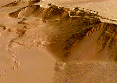 Lava flows are up to 200 million years old and the network-bearing area was geologically active as recent as 30 million years ago. -------------------- - blue_scape / Nico -
|
 |
 
|
 |
|
May 10 2006, 07:05 PM
Post
#2
|
|
|
Solar System Cartographer Group: Members Posts: 10153 Joined: 5-April 05 From: Canada Member No.: 227 |
Nice one, Doug - look at the cloud shadows! If the sun elevation is known the cloud height can be calculated.
Phil -------------------- ... because the Solar System ain't gonna map itself.
Also to be found posting similar content on https://mastodon.social/@PhilStooke Maps for download (free PD: https://upload.wikimedia.org/wikipedia/comm...Cartography.pdf NOTE: everything created by me which I post on UMSF is considered to be in the public domain (NOT CC, public domain) |
|
|
|
|
May 10 2006, 07:53 PM
Post
#3
|
|
 Dublin Correspondent Group: Admin Posts: 1799 Joined: 28-March 05 From: Celbridge, Ireland Member No.: 220 |
QUOTE (Phil Stooke @ May 10 2006, 08:05 PM)  Nice one, Doug - look at the cloud shadows! If the sun elevation is known the cloud height can be calculated. Well from plugging the average time given for the image (2004-11-23 16:11:22) Latitude (20.2913N) and longitude (-230.7915W) into mars 24 I get a Solar Elevation of 53.7deg and Solar Azimuth of 279.9deg if that's any help. |
|
|
|
|
May 10 2006, 08:12 PM
Post
#4
|
|
|
Dublin Correspondent Group: Admin Posts: 1799 Joined: 28-March 05 From: Celbridge, Ireland Member No.: 220 |
QUOTE (helvick @ May 10 2006, 08:53 PM) Well from plugging the average time given for the image (2004-11-23 16:11:22) Latitude (20.2913N) and longitude (-230.7915W) into mars 24 I get a Solar Elevation of 53.7deg and Solar Azimuth of 279.9deg if that's any help. Hmmh - I measure about 62 pixels between the clouds and their shadows in the middle of the picture. According to the metadata the resolution is approx 90.9m/pixel. With the above solar elevation I get an altitude of around 7.67km above the surface (where the shadow is) for those clouds. |
|
|
|
 SigurRosFan New Olympus Mons image Mar 3 2006, 03:16 PM
 Richard Trigaux I alway wondered where this huge scarp is coming f... Mar 3 2006, 03:38 PM
 Richard Trigaux QUOTE (Richard Trigaux @ Mar 3 2006, 04:3... Mar 5 2006, 07:26 AM SigurRosFan QUOTE I alway wondered where this huge scarp is co... Mar 4 2006, 07:01 PM Decepticon I remember reading Olympus Mons is not the tallest... Mar 4 2006, 08:05 PM Jyril No, Olympus Mons is the tallest mountain.
I remem... Mar 4 2006, 08:13 PM Nix Amazing images
Nico Mar 4 2006, 10:51 PM David Olympus Mons is so huge that you could probably la... Mar 5 2006, 03:32 AM edstrick MOLA proved that Arsia or one of the 3 tharsis vol... Mar 5 2006, 07:48 AM Richard Trigaux QUOTE (edstrick @ Mar 5 2006, 08:48 AM) M... Mar 5 2006, 07:54 AM RNeuhaus QUOTE (edstrick @ Mar 5 2006, 02:48 AM) M... May 10 2006, 08:08 PM edstrick There's clear evidence for catastrophic landsl... Mar 5 2006, 09:26 AM Richard Trigaux QUOTE (edstrick @ Mar 5 2006, 10:26 AM) T... Mar 6 2006, 07:11 PM tty Huge peripheral landslides may be a quite normal p... Mar 5 2006, 05:28 PM Richard Trigaux QUOTE (tty @ Mar 5 2006, 06:28 PM) Huge p... Mar 6 2006, 06:47 PM edstrick One of the mid-sized Hawiian islands has coral chu... Mar 6 2006, 08:03 AM Richard Trigaux Googling ""Olympus Mons Aureole" (w... Mar 6 2006, 07:29 PM ljk4-1 This image of an area near Olympus Mons reminds me... May 10 2006, 05:47 PM djellison Just out of pure curiosity, I found the orig. data... May 10 2006, 06:26 PM Bob Shaw QUOTE (Phil Stooke @ May 10 2006, 08:05 P... May 10 2006, 07:27 PM helvick QUOTE (helvick @ May 10 2006, 09:12 PM) H... May 10 2006, 08:40 PM djellison Unfortunately, ESA being ESA - they've not gon... May 10 2006, 07:12 PM jaywee QUOTE (djellison @ May 10 2006, 09:12 PM)... May 11 2006, 04:14 AM djellison Mars 24 - of COURSE.....stupid me, should have tho... May 10 2006, 08:16 PM djellison Well - the Spice data's going to tell you wher... May 11 2006, 07:45 AM edstrick "....I can't remember actually noticing *... May 11 2006, 11:00 AM
Richard Trigaux QUOTE (Richard Trigaux @ Mar 3 2006, 04:3... Mar 5 2006, 07:26 AM SigurRosFan QUOTE I alway wondered where this huge scarp is co... Mar 4 2006, 07:01 PM Decepticon I remember reading Olympus Mons is not the tallest... Mar 4 2006, 08:05 PM Jyril No, Olympus Mons is the tallest mountain.
I remem... Mar 4 2006, 08:13 PM Nix Amazing images
Nico Mar 4 2006, 10:51 PM David Olympus Mons is so huge that you could probably la... Mar 5 2006, 03:32 AM edstrick MOLA proved that Arsia or one of the 3 tharsis vol... Mar 5 2006, 07:48 AM Richard Trigaux QUOTE (edstrick @ Mar 5 2006, 08:48 AM) M... Mar 5 2006, 07:54 AM RNeuhaus QUOTE (edstrick @ Mar 5 2006, 02:48 AM) M... May 10 2006, 08:08 PM edstrick There's clear evidence for catastrophic landsl... Mar 5 2006, 09:26 AM Richard Trigaux QUOTE (edstrick @ Mar 5 2006, 10:26 AM) T... Mar 6 2006, 07:11 PM tty Huge peripheral landslides may be a quite normal p... Mar 5 2006, 05:28 PM Richard Trigaux QUOTE (tty @ Mar 5 2006, 06:28 PM) Huge p... Mar 6 2006, 06:47 PM edstrick One of the mid-sized Hawiian islands has coral chu... Mar 6 2006, 08:03 AM Richard Trigaux Googling ""Olympus Mons Aureole" (w... Mar 6 2006, 07:29 PM ljk4-1 This image of an area near Olympus Mons reminds me... May 10 2006, 05:47 PM djellison Just out of pure curiosity, I found the orig. data... May 10 2006, 06:26 PM Bob Shaw QUOTE (Phil Stooke @ May 10 2006, 08:05 P... May 10 2006, 07:27 PM helvick QUOTE (helvick @ May 10 2006, 09:12 PM) H... May 10 2006, 08:40 PM djellison Unfortunately, ESA being ESA - they've not gon... May 10 2006, 07:12 PM jaywee QUOTE (djellison @ May 10 2006, 09:12 PM)... May 11 2006, 04:14 AM djellison Mars 24 - of COURSE.....stupid me, should have tho... May 10 2006, 08:16 PM djellison Well - the Spice data's going to tell you wher... May 11 2006, 07:45 AM edstrick "....I can't remember actually noticing *... May 11 2006, 11:00 AM |

|
Lo-Fi Version | Time is now: 30th April 2024 - 08:58 PM |
|
RULES AND GUIDELINES Please read the Forum Rules and Guidelines before posting. IMAGE COPYRIGHT |
OPINIONS AND MODERATION Opinions expressed on UnmannedSpaceflight.com are those of the individual posters and do not necessarily reflect the opinions of UnmannedSpaceflight.com or The Planetary Society. The all-volunteer UnmannedSpaceflight.com moderation team is wholly independent of The Planetary Society. The Planetary Society has no influence over decisions made by the UnmannedSpaceflight.com moderators. |
SUPPORT THE FORUM Unmannedspaceflight.com is funded by the Planetary Society. Please consider supporting our work and many other projects by donating to the Society or becoming a member. |
|


