
New Olympus Mons image, 6 km high scarp |

New Olympus Mons image, 6 km high scarp |
 Mar 3 2006, 03:16 PM Mar 3 2006, 03:16 PM
Post
#1
|
|
 Member  Group: Members Posts: 531 Joined: 24-August 05 Member No.: 471 |
http://www.esa.int/SPECIALS/Mars_Express/SEMIPVMVGJE_0.html - Eastern scarp of Olympus Mons (Press Information)
http://www.esa.int/SPECIALS/Mars_Express/SEMIPVMVGJE_1.html - Eastern scarp of Olympus Mons (Images) Image was taken on Nov. 23, 2004: 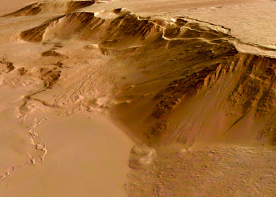 Lava flows are up to 200 million years old and the network-bearing area was geologically active as recent as 30 million years ago. -------------------- - blue_scape / Nico -
|
 |
 
|
 |
|
May 10 2006, 07:05 PM
Post
#2
|
|
|
Solar System Cartographer Group: Members Posts: 10153 Joined: 5-April 05 From: Canada Member No.: 227 |
Nice one, Doug - look at the cloud shadows! If the sun elevation is known the cloud height can be calculated.
Phil -------------------- ... because the Solar System ain't gonna map itself.
Also to be found posting similar content on https://mastodon.social/@PhilStooke Maps for download (free PD: https://upload.wikimedia.org/wikipedia/comm...Cartography.pdf NOTE: everything created by me which I post on UMSF is considered to be in the public domain (NOT CC, public domain) |
|
|
|
|
May 10 2006, 07:53 PM
Post
#3
|
|
 Dublin Correspondent Group: Admin Posts: 1799 Joined: 28-March 05 From: Celbridge, Ireland Member No.: 220 |
QUOTE (Phil Stooke @ May 10 2006, 08:05 PM)  Nice one, Doug - look at the cloud shadows! If the sun elevation is known the cloud height can be calculated. Well from plugging the average time given for the image (2004-11-23 16:11:22) Latitude (20.2913N) and longitude (-230.7915W) into mars 24 I get a Solar Elevation of 53.7deg and Solar Azimuth of 279.9deg if that's any help. |
|
|
|
|
May 10 2006, 08:12 PM
Post
#4
|
|
|
Dublin Correspondent Group: Admin Posts: 1799 Joined: 28-March 05 From: Celbridge, Ireland Member No.: 220 |
QUOTE (helvick @ May 10 2006, 08:53 PM) Well from plugging the average time given for the image (2004-11-23 16:11:22) Latitude (20.2913N) and longitude (-230.7915W) into mars 24 I get a Solar Elevation of 53.7deg and Solar Azimuth of 279.9deg if that's any help. Hmmh - I measure about 62 pixels between the clouds and their shadows in the middle of the picture. According to the metadata the resolution is approx 90.9m/pixel. With the above solar elevation I get an altitude of around 7.67km above the surface (where the shadow is) for those clouds. |
|
|
|
|
May 10 2006, 08:40 PM
Post
#5
|
|
|
Dublin Correspondent Group: Admin Posts: 1799 Joined: 28-March 05 From: Celbridge, Ireland Member No.: 220 |
QUOTE (helvick @ May 10 2006, 09:12 PM) Hmmh - I measure about 62 pixels between the clouds and their shadows in the middle of the picture. According to the metadata the resolution is approx 90.9m/pixel. With the above solar elevation I get an altitude of around 7.67km above the surface (where the shadow is) for those clouds. A quick and dirty look at the MOLA elevation data for this spot on Google Mars puts the area where the shadow is at somewhere around 3km above datum which puts these clouds 10km below the top of Olympus so they are possibly water clouds. |
|
|
|
 SigurRosFan New Olympus Mons image Mar 3 2006, 03:16 PM
 Richard Trigaux I alway wondered where this huge scarp is coming f... Mar 3 2006, 03:38 PM
 Richard Trigaux QUOTE (Richard Trigaux @ Mar 3 2006, 04:3... Mar 5 2006, 07:26 AM SigurRosFan QUOTE I alway wondered where this huge scarp is co... Mar 4 2006, 07:01 PM Decepticon I remember reading Olympus Mons is not the tallest... Mar 4 2006, 08:05 PM Jyril No, Olympus Mons is the tallest mountain.
I remem... Mar 4 2006, 08:13 PM Nix Amazing images
Nico Mar 4 2006, 10:51 PM David Olympus Mons is so huge that you could probably la... Mar 5 2006, 03:32 AM edstrick MOLA proved that Arsia or one of the 3 tharsis vol... Mar 5 2006, 07:48 AM Richard Trigaux QUOTE (edstrick @ Mar 5 2006, 08:48 AM) M... Mar 5 2006, 07:54 AM RNeuhaus QUOTE (edstrick @ Mar 5 2006, 02:48 AM) M... May 10 2006, 08:08 PM edstrick There's clear evidence for catastrophic landsl... Mar 5 2006, 09:26 AM Richard Trigaux QUOTE (edstrick @ Mar 5 2006, 10:26 AM) T... Mar 6 2006, 07:11 PM tty Huge peripheral landslides may be a quite normal p... Mar 5 2006, 05:28 PM Richard Trigaux QUOTE (tty @ Mar 5 2006, 06:28 PM) Huge p... Mar 6 2006, 06:47 PM edstrick One of the mid-sized Hawiian islands has coral chu... Mar 6 2006, 08:03 AM Richard Trigaux Googling ""Olympus Mons Aureole" (w... Mar 6 2006, 07:29 PM ljk4-1 This image of an area near Olympus Mons reminds me... May 10 2006, 05:47 PM djellison Just out of pure curiosity, I found the orig. data... May 10 2006, 06:26 PM Bob Shaw QUOTE (Phil Stooke @ May 10 2006, 08:05 P... May 10 2006, 07:27 PM djellison Unfortunately, ESA being ESA - they've not gon... May 10 2006, 07:12 PM jaywee QUOTE (djellison @ May 10 2006, 09:12 PM)... May 11 2006, 04:14 AM djellison Mars 24 - of COURSE.....stupid me, should have tho... May 10 2006, 08:16 PM djellison Well - the Spice data's going to tell you wher... May 11 2006, 07:45 AM edstrick "....I can't remember actually noticing *... May 11 2006, 11:00 AM
Richard Trigaux QUOTE (Richard Trigaux @ Mar 3 2006, 04:3... Mar 5 2006, 07:26 AM SigurRosFan QUOTE I alway wondered where this huge scarp is co... Mar 4 2006, 07:01 PM Decepticon I remember reading Olympus Mons is not the tallest... Mar 4 2006, 08:05 PM Jyril No, Olympus Mons is the tallest mountain.
I remem... Mar 4 2006, 08:13 PM Nix Amazing images
Nico Mar 4 2006, 10:51 PM David Olympus Mons is so huge that you could probably la... Mar 5 2006, 03:32 AM edstrick MOLA proved that Arsia or one of the 3 tharsis vol... Mar 5 2006, 07:48 AM Richard Trigaux QUOTE (edstrick @ Mar 5 2006, 08:48 AM) M... Mar 5 2006, 07:54 AM RNeuhaus QUOTE (edstrick @ Mar 5 2006, 02:48 AM) M... May 10 2006, 08:08 PM edstrick There's clear evidence for catastrophic landsl... Mar 5 2006, 09:26 AM Richard Trigaux QUOTE (edstrick @ Mar 5 2006, 10:26 AM) T... Mar 6 2006, 07:11 PM tty Huge peripheral landslides may be a quite normal p... Mar 5 2006, 05:28 PM Richard Trigaux QUOTE (tty @ Mar 5 2006, 06:28 PM) Huge p... Mar 6 2006, 06:47 PM edstrick One of the mid-sized Hawiian islands has coral chu... Mar 6 2006, 08:03 AM Richard Trigaux Googling ""Olympus Mons Aureole" (w... Mar 6 2006, 07:29 PM ljk4-1 This image of an area near Olympus Mons reminds me... May 10 2006, 05:47 PM djellison Just out of pure curiosity, I found the orig. data... May 10 2006, 06:26 PM Bob Shaw QUOTE (Phil Stooke @ May 10 2006, 08:05 P... May 10 2006, 07:27 PM djellison Unfortunately, ESA being ESA - they've not gon... May 10 2006, 07:12 PM jaywee QUOTE (djellison @ May 10 2006, 09:12 PM)... May 11 2006, 04:14 AM djellison Mars 24 - of COURSE.....stupid me, should have tho... May 10 2006, 08:16 PM djellison Well - the Spice data's going to tell you wher... May 11 2006, 07:45 AM edstrick "....I can't remember actually noticing *... May 11 2006, 11:00 AM |

|
Lo-Fi Version | Time is now: 30th April 2024 - 12:42 PM |
|
RULES AND GUIDELINES Please read the Forum Rules and Guidelines before posting. IMAGE COPYRIGHT |
OPINIONS AND MODERATION Opinions expressed on UnmannedSpaceflight.com are those of the individual posters and do not necessarily reflect the opinions of UnmannedSpaceflight.com or The Planetary Society. The all-volunteer UnmannedSpaceflight.com moderation team is wholly independent of The Planetary Society. The Planetary Society has no influence over decisions made by the UnmannedSpaceflight.com moderators. |
SUPPORT THE FORUM Unmannedspaceflight.com is funded by the Planetary Society. Please consider supporting our work and many other projects by donating to the Society or becoming a member. |
|


