The Top of Vera Rubin Ridge Part 2, Site 67-73, sol 1944-2297, 24 Jan 2018-22 Jan 2019 |

  |
The Top of Vera Rubin Ridge Part 2, Site 67-73, sol 1944-2297, 24 Jan 2018-22 Jan 2019 |
 Mar 6 2018, 12:36 AM Mar 6 2018, 12:36 AM
Post
#61
|
|
|
Solar System Cartographer  Group: Members Posts: 10154 Joined: 5-April 05 From: Canada Member No.: 227 |
Regarding the Peace Vallis RMI images - we have two nice sequences very recently which I hope somebody will mosaic for us - you may find this new LPSC abstract useful:
https://www.hou.usra.edu/meetings/lpsc2018/pdf/2965.pdf Interesting information on RMI and Mastcam observations including "super-resolution" efforts. Phil -------------------- ... because the Solar System ain't gonna map itself.
Also to be found posting similar content on https://mastodon.social/@PhilStooke Maps for download (free PD: https://upload.wikimedia.org/wikipedia/comm...Cartography.pdf NOTE: everything created by me which I post on UMSF is considered to be in the public domain (NOT CC, public domain) |
 |
 
|
|
Mar 6 2018, 01:46 AM
Post
#62
|
|
 Senior Member Group: Members Posts: 2428 Joined: 30-January 13 From: Penang, Malaysia. Member No.: 6853 |
Nice find Phil, would be nice to see those figures used in that abstract at the full resolution one day, especially the "super-resolution" observations
 |
|
|
|
|
Mar 6 2018, 02:39 AM
Post
#63
|
||
|
Solar System Cartographer Group: Members Posts: 10154 Joined: 5-April 05 From: Canada Member No.: 227 |
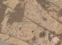
I've updated the annotated image of the workspace to include the new drill attempt.
Phil
-------------------- ... because the Solar System ain't gonna map itself.
Also to be found posting similar content on https://mastodon.social/@PhilStooke Maps for download (free PD: https://upload.wikimedia.org/wikipedia/comm...Cartography.pdf NOTE: everything created by me which I post on UMSF is considered to be in the public domain (NOT CC, public domain) |
|
|
|
|
|
|
Mar 6 2018, 05:22 AM
Post
#64
|
||
|
Senior Member Group: Members Posts: 2428 Joined: 30-January 13 From: Penang, Malaysia. Member No.: 6853 |
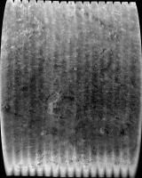
Hope someone with more skills and professional applications can have a go at assembling the Peace Vallis mosaics. ICE running on my old laptop will only join these 17 of the 20 in this set from 1981, and that was after much trial and error in cropping away the bright borders (vignetting?) from the overlapping regions before dropping into ICE. No additional processing was done on the images, just cropping and then into ICE.
|
|
|
|
|
|
|
Mar 6 2018, 07:28 AM
Post
#65
|
||
|
Solar System Cartographer Group: Members Posts: 10154 Joined: 5-April 05 From: Canada Member No.: 227 |
Thanks, Paul. That image might seem hard to interpret or do anything with (not Paul's fault! It's the geometry) but look what happens when you stretch it out vertically to counter the foreshortening:
Imagine doing this with all the mosaics of the fan. Eventually you get good coverage of large areas with lots of scope for analysis of the geomorphology.
Phil -------------------- ... because the Solar System ain't gonna map itself.
Also to be found posting similar content on https://mastodon.social/@PhilStooke Maps for download (free PD: https://upload.wikimedia.org/wikipedia/comm...Cartography.pdf NOTE: everything created by me which I post on UMSF is considered to be in the public domain (NOT CC, public domain) |
|
|
|
|
|
|
Mar 6 2018, 07:48 AM
Post
#66
|
|
|
Senior Member Group: Members Posts: 2428 Joined: 30-January 13 From: Penang, Malaysia. Member No.: 6853 |
QUOTE (Phil Stooke @ Mar 6 2018, 03:28 PM)  Imagine doing this with all the mosaics of the fan. Eventually you get good coverage of large areas with lots of scope for analysis of the geomorphology. That certainly provides a different perspective
|
|
|
|
|
Mar 7 2018, 12:54 AM
Post
#67
|
|||
|
Member Group: Members Posts: 306 Joined: 4-October 14 Member No.: 7273 |
Taking Phil's idea and running with it a bit: a rough foreshortened-corrected 40 image RMI mosaic, and an animated map-projected version overlaid on the USGS orthophoto image of Gale Crater. Will definitely need to check this out with PDS data once it's released.
Attached thumbnail(s)
|
||
|
|
|
||
|
Mar 7 2018, 12:56 AM
Post
#68
|
||
|
Member Group: Members Posts: 306 Joined: 4-October 14 Member No.: 7273 |
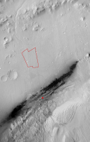
Double-post just to add another attachment, which has Curiosity's current location as a red X and an outline of the RMI mosaic footprint.
Attached thumbnail(s)
|
|
|
|
|
|
|
Mar 7 2018, 01:31 AM
Post
#69
|
||
|
Senior Member Group: Members Posts: 2428 Joined: 30-January 13 From: Penang, Malaysia. Member No.: 6853 |
Fantastic work on the RMI mosaics guys
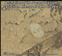
Simple animated GIF of the second sample acquisition attempt at Lake Orcadie 2 (1.5 second blink rate) Source frames (sol 1980 & sol 1983) Margins added to roughly align the frames. Now time to seek 'Softer Pastures'
|
|
|
|
|
|
|
Mar 7 2018, 01:52 AM
Post
#70
|
|
|
Solar System Cartographer Group: Members Posts: 10154 Joined: 5-April 05 From: Canada Member No.: 227 |
Wow, Justin - fantastic results!
Phil -------------------- ... because the Solar System ain't gonna map itself.
Also to be found posting similar content on https://mastodon.social/@PhilStooke Maps for download (free PD: https://upload.wikimedia.org/wikipedia/comm...Cartography.pdf NOTE: everything created by me which I post on UMSF is considered to be in the public domain (NOT CC, public domain) |
|
|
|
|
Mar 7 2018, 11:17 AM
Post
#71
|
||
|
Senior Member Group: Members Posts: 2428 Joined: 30-January 13 From: Penang, Malaysia. Member No.: 6853 |
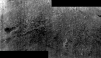
Here is my version of the sol 1984 long-distance RMI mosaic that the sol 1984 mission update refers to as 'a portion of the clay unit that represents part of Curiosity's future agenda'. I have sharpened the images a little before assembling in ICE. There was also another RMI sequence of the PV fan, but I think I best leave that mosaic to Justin and the other experts
|
|
|
|
|
|
|
Mar 8 2018, 10:40 AM
Post
#72
|
||
|
Senior Member Group: Members Posts: 2822 Joined: 22-April 05 From: Ridderkerk, Netherlands Member No.: 353 |
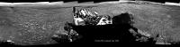
The Navcam L panoramic view on Sol 1985.
Jan van Driel
|
|
|
|
|
|
|
Mar 8 2018, 11:32 AM
Post
#73
|
|
 Senior Member Group: Members Posts: 1619 Joined: 12-February 06 From: Bergerac - FR Member No.: 678 |
Sol 1985 Navcam panoramic
-------------------- |
|
|
|
|
Mar 8 2018, 08:23 PM
Post
#74
|
||
|
Solar System Cartographer Group: Members Posts: 10154 Joined: 5-April 05 From: Canada Member No.: 227 |
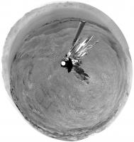
Thanks for that nice panorama! Here is a circular projection of it. You can see the tracks leading up from the previous outcrop site to the current location, almost in a straight line.
Phil
-------------------- ... because the Solar System ain't gonna map itself.
Also to be found posting similar content on https://mastodon.social/@PhilStooke Maps for download (free PD: https://upload.wikimedia.org/wikipedia/comm...Cartography.pdf NOTE: everything created by me which I post on UMSF is considered to be in the public domain (NOT CC, public domain) |
|
|
|
|
|
|
Mar 8 2018, 11:15 PM
Post
#75
|
||
|
Senior Member Group: Members Posts: 2428 Joined: 30-January 13 From: Penang, Malaysia. Member No.: 6853 |
Nice work on the 360's and the circular projection
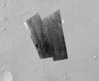
Here's the Sol 1985 L-MastCam Workspace mosaic. Unprocessed, only assembled in MS ICE. No contact science planned on this gravelly patch of ground, so another drive is planned for 1986 heading towards the Northeast
|
|
|
|
|
|
|

|
Lo-Fi Version | Time is now: 1st May 2024 - 05:27 AM |
|
RULES AND GUIDELINES Please read the Forum Rules and Guidelines before posting. IMAGE COPYRIGHT |
OPINIONS AND MODERATION Opinions expressed on UnmannedSpaceflight.com are those of the individual posters and do not necessarily reflect the opinions of UnmannedSpaceflight.com or The Planetary Society. The all-volunteer UnmannedSpaceflight.com moderation team is wholly independent of The Planetary Society. The Planetary Society has no influence over decisions made by the UnmannedSpaceflight.com moderators. |
SUPPORT THE FORUM Unmannedspaceflight.com is funded by the Planetary Society. Please consider supporting our work and many other projects by donating to the Society or becoming a member. |
|