Yutu Route Map |

  |
Yutu Route Map |
 Dec 28 2013, 09:52 PM Dec 28 2013, 09:52 PM
Post
#16
|
||
|
Solar System Cartographer  Group: Members Posts: 10226 Joined: 5-April 05 From: Canada Member No.: 227 |
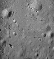
This is a very tentative map update. We have no images to help with the current position, but there is a report that the rover is 40 m south of the lander and 'a little bit left' which I am interpreting to mean left on a north-up map, not left as the rover drove.
So... position is very tentative and the shape of the route unknown, and even the date of the drive is uncertain. So all this may be changed later. But for now it's the best we can do. Phil
-------------------- ... because the Solar System ain't gonna map itself.
Also to be found posting similar content on https://mastodon.social/@PhilStooke Maps for download (free PDF: https://upload.wikimedia.org/wikipedia/comm...Cartography.pdf NOTE: everything created by me which I post on UMSF is considered to be in the public domain (NOT CC, public domain) |
|
 |
 
|
|
|
Dec 30 2013, 11:36 PM
Post
#17
|
||
 Senior Member Group: Members Posts: 1089 Joined: 19-February 05 From: Close to Meudon Observatory in France Member No.: 172 |
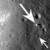
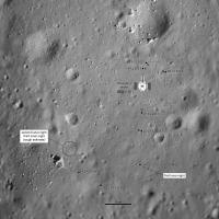
QUOTE (Phil Stooke @ Dec 28 2013, 10:52 PM)  So... position is very tentative and the shape of the route unknown, and even the date of the drive is uncertain. So all this may be changed later. But for now it's the best we can do. Phil Great : you did it quite good Phil ! Here is the LRO image : congratulations to you again for your new Yu-Tu positioning close to the spot on the LRO image (small arrow) with almost no data at all ...and Happy NEW YEAR's Eve ! 
|
|
|
|
|
|
|
Dec 31 2013, 02:44 AM
Post
#18
|
|
|
Founder Group: Chairman Posts: 14434 Joined: 8-February 04 Member No.: 1 |
QUOTE (vikingmars @ Dec 30 2013, 03:36 PM) Here is the LRO image HERE is the LRO Image. http://lroc.sese.asu.edu/news/index.php?/a...From-Above.html |
|
|
|
|
Dec 31 2013, 02:47 AM
Post
#19
|
||
|
Solar System Cartographer Group: Members Posts: 10226 Joined: 5-April 05 From: Canada Member No.: 227 |
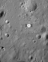
Merci! Here's another update including a sketch of the lander - though I'm not sure of the exact dimensions of the lander... and corrected to use the LRO position for Yutu.
Since we will presumably never have daily status reports, this map will always be a work in progress, updated from every scrap of information we get. Phil
-------------------- ... because the Solar System ain't gonna map itself.
Also to be found posting similar content on https://mastodon.social/@PhilStooke Maps for download (free PDF: https://upload.wikimedia.org/wikipedia/comm...Cartography.pdf NOTE: everything created by me which I post on UMSF is considered to be in the public domain (NOT CC, public domain) |
|
|
|
|
|
|
Dec 31 2013, 03:32 AM
Post
#20
|
|
|
Senior Member Group: Members Posts: 2106 Joined: 13-February 10 From: Ontario Member No.: 5221 |
LRO can make up for the lack of reports quite easily, given the regular flyover schedule. I expect you'll miss learning any creative names they give to sites and targets more Phil (if they even have more than numbers)!
|
|
|
|
|
Dec 31 2013, 04:00 AM
Post
#21
|
|
|
Solar System Cartographer Group: Members Posts: 10226 Joined: 5-April 05 From: Canada Member No.: 227 |
I'm hoping for a few names!
Phil -------------------- ... because the Solar System ain't gonna map itself.
Also to be found posting similar content on https://mastodon.social/@PhilStooke Maps for download (free PDF: https://upload.wikimedia.org/wikipedia/comm...Cartography.pdf NOTE: everything created by me which I post on UMSF is considered to be in the public domain (NOT CC, public domain) |
|
|
|
|
Jan 15 2014, 12:12 AM
Post
#22
|
||
|
Solar System Cartographer Group: Members Posts: 10226 Joined: 5-April 05 From: Canada Member No.: 227 |
Map update to 14 January - I don't know the date of the drive or the path, so this is conjectural, but the position should be OK. Since the last map I have corrected the size of the lander.
(EDIT - replaced with an update with the latest position, but I'm leaving it undated until I know more) Phil
-------------------- ... because the Solar System ain't gonna map itself.
Also to be found posting similar content on https://mastodon.social/@PhilStooke Maps for download (free PDF: https://upload.wikimedia.org/wikipedia/comm...Cartography.pdf NOTE: everything created by me which I post on UMSF is considered to be in the public domain (NOT CC, public domain) |
|
|
|
|
|
|
Jan 19 2014, 08:32 PM
Post
#23
|
||
|
Junior Member Group: Members Posts: 45 Joined: 18-July 05 Member No.: 439 |
In a Chinese news report from Jan 14 current position was pictured as -32.61 meters (south) and -24.63 meters (west). Can't say what frame is in use -- either from lander or from the X point at the end of rails. The third number (27.17) relates to Yutu's attitude. The one to the right (129.23) is the Sun azimuth. There's also the fifth number outside of this frame -- Sun elevation (34.42 or so). Hope this helps to check/correct Phil's map.
Attached thumbnail(s)
|
|
|
|
|
|
|
Jan 19 2014, 10:45 PM
Post
#24
|
|
|
Junior Member Group: Members Posts: 45 Joined: 18-July 05 Member No.: 439 |
Similar data were found for points A (15 Dec 2013) and E (22 Dec 2013). With reservations about guessing blurred figures, here are these:
Point A -- 9.03 N, 1.55 E, Az = -171.08 Point E -- 30.97 S, 0.64 W, Az = 174.80 As LRO found Yutu to rest some 30-31 meters from CE3, we should believe positions are consistently measured from CE3. Jia Yang's 'more than 40 meters' may be from point X -- or even along the track. |
|
|
|
|
Jan 19 2014, 11:42 PM
Post
#25
|
||
|
Solar System Cartographer Group: Members Posts: 10226 Joined: 5-April 05 From: Canada Member No.: 227 |
Interesting! Here is my map with a 10 m grid superimposed and aligned with the lander. The coordinates match the Jan. 14 position well, except 'point E' refers to the point south of my E.
Phil
-------------------- ... because the Solar System ain't gonna map itself.
Also to be found posting similar content on https://mastodon.social/@PhilStooke Maps for download (free PDF: https://upload.wikimedia.org/wikipedia/comm...Cartography.pdf NOTE: everything created by me which I post on UMSF is considered to be in the public domain (NOT CC, public domain) |
|
|
|
|
|
|
Jan 20 2014, 01:13 AM
Post
#26
|
|
|
Junior Member Group: Members Posts: 45 Joined: 18-July 05 Member No.: 439 |
Phil, you are right and I was wrong!
What I referred to as point E was in fact point of night sleep, recorded on December 26 and January 8. |
|
|
|
|
Feb 23 2014, 04:20 PM
Post
#27
|
||
|
Solar System Cartographer Group: Members Posts: 10226 Joined: 5-April 05 From: Canada Member No.: 227 |
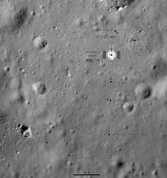
As you know there has been very little information since mid-January. I have updated this map to suggest where we might be based on three very uncertain thoughts.
1. The direction the lander is viewed from in the most recent image. 2. A statement that the distance driven was 'over 100 m' which I interpret as 'only slightly over 100 m'. 3. An earlier statement that the big rock was a target for the rover instruments. Phil
-------------------- ... because the Solar System ain't gonna map itself.
Also to be found posting similar content on https://mastodon.social/@PhilStooke Maps for download (free PDF: https://upload.wikimedia.org/wikipedia/comm...Cartography.pdf NOTE: everything created by me which I post on UMSF is considered to be in the public domain (NOT CC, public domain) |
|
|
|
|
|
|
Feb 23 2014, 04:31 PM
Post
#28
|
|
 Administrator Group: Admin Posts: 5172 Joined: 4-August 05 From: Pasadena, CA, USA, Earth Member No.: 454 |
I'm sort of surprised we haven't seen any further photos from LROC that would help localize the rover.
-------------------- My website - My Patreon - @elakdawalla on Twitter - Please support unmannedspaceflight.com by donating here.
|
|
|
|
|
Feb 23 2014, 05:34 PM
Post
#29
|
|
|
Solar System Cartographer Group: Members Posts: 10226 Joined: 5-April 05 From: Canada Member No.: 227 |
Yes, we are overdue - some were expected during day 2 but have not been released (if taken). I could really use an LROC-NAC about now!
Phil -------------------- ... because the Solar System ain't gonna map itself.
Also to be found posting similar content on https://mastodon.social/@PhilStooke Maps for download (free PDF: https://upload.wikimedia.org/wikipedia/comm...Cartography.pdf NOTE: everything created by me which I post on UMSF is considered to be in the public domain (NOT CC, public domain) |
|
|
|
|
Feb 24 2014, 05:32 PM
Post
#30
|
|
|
Administrator Group: Admin Posts: 5172 Joined: 4-August 05 From: Pasadena, CA, USA, Earth Member No.: 454 |
Since it took me a while to dig it up, I'll post in here a link to Mark Robinson's LPSC abstract on LROC imaging of the Chang'e 3 landing site, and a clip of the table of information on planned images:
CODE Image Sample Line Incidence Emission Phase Scale (m/px) Date
M102285549LE 2645 48154 -81 2 82 1.7 2009-07-15 M181302794LE 2478 39772 -72 2 74 1.6 2012-01-15 M183661683LE 4784 22098 -54 0 54 1.6 2012-02-12 M1116664800RE 3639 6405 -44 2 44 1.5 2013-02-28 M1127248516RE 2283 33974 -76 1 75 1.5 2013-06-30 M1129602407LE 2846 31480 -59 2 60 1.6 2013-07-27 M1142554338LE 4549 15684 -74 33 106 1.8 2013-12-24 M1142568554LE 4184 20330 -75 17 92 1.6 2013-12-24 M1142582775RE 1550 20621 -77 2 75 1.5 2013-12-25 M1142596997RE 845 20800 -78 20 58 1.6 2013-12-25 M1142625444RE 1477 16571 -81 48 36 2.1 2013-12-25 M1142682346RE 1112 10474 -87 72 21 3.8 2013-12-26 Table 1. Summary of LROC NAC images and pixel coordinates of Chang'e 3 lander, entries in italics acquired after landing. Future imaging opportunities occur 2014-01-22, 2014-02-19, 2014-03-19. Negative incidence angle indicates Sun from the west. -------------------- My website - My Patreon - @elakdawalla on Twitter - Please support unmannedspaceflight.com by donating here.
|
|
|
|
|

|
Lo-Fi Version | Time is now: 23rd September 2024 - 07:52 PM |
|
RULES AND GUIDELINES Please read the Forum Rules and Guidelines before posting. IMAGE COPYRIGHT |
OPINIONS AND MODERATION Opinions expressed on UnmannedSpaceflight.com are those of the individual posters and do not necessarily reflect the opinions of UnmannedSpaceflight.com or The Planetary Society. The all-volunteer UnmannedSpaceflight.com moderation team is wholly independent of The Planetary Society. The Planetary Society has no influence over decisions made by the UnmannedSpaceflight.com moderators. |
SUPPORT THE FORUM Unmannedspaceflight.com is funded by the Planetary Society. Please consider supporting our work and many other projects by donating to the Society or becoming a member. |
|