Back At Larry's Lookout |

  |
Back At Larry's Lookout |
| Guest_Sunspot_* |
 May 18 2005, 06:29 PM May 18 2005, 06:29 PM
Post
#1
|
|
Guests |
Some pretty complex driving by the look of it:
http://qt.exploratorium.edu/mars/spirit/fo...E0P1214R0M1.JPG Now this is odd: http://qt.exploratorium.edu/mars/spirit/na...E0P0617R0M1.JPG It looks like some of the rocks have slid down the dune 
|
 |
 
|
|
May 18 2005, 06:37 PM
Post
#2
|
|
|
Senior Member  Group: Members Posts: 2998 Joined: 30-October 04 Member No.: 105 |
Fascinating image. I'm not one of the "water, water everywhere..." crowd, but that odd pattern in the dust immediately below the bluff outcrop looks positively _splat-like_.
What do you make of it? --Bill -------------------- |
|
|
|
| Guest_Sunspot_* |
May 18 2005, 06:40 PM
Post
#3
|
|
Guests |
I thought it looked like a thin/harder crust on top of the dune had slid down slightly.
|
|
|
|
|
May 18 2005, 07:13 PM
Post
#4
|
|
 Senior Member Group: Moderator Posts: 3431 Joined: 11-August 04 From: USA Member No.: 98 |
QUOTE (Sunspot @ May 18 2005, 06:40 PM) I thought it looked like a thin/harder crust on top of the dune had slid down slightly.  Another view: http://nasa.exploratorium.edu/mars/spirit/...E0P0123L0M1.JPG |
|
|
|
|
May 18 2005, 07:22 PM
Post
#5
|
|
 Member Group: Members Posts: 154 Joined: 17-March 05 Member No.: 206 |
That is my take of it too: A hard, plate-like crust slipped down the incline during the recent past. Of course, it begs the question, why is there crust at that spot?

|
|
|
|
|
May 18 2005, 08:25 PM
Post
#6
|
|
 Member Group: Members Posts: 700 Joined: 3-December 04 From: Boulder, Colorado, USA Member No.: 117 |
QUOTE (Chmee @ May 18 2005, 07:22 PM) That is my take of it too: A hard, plate-like crust slipped down the incline during the recent past. Of course, it begs the question, why is there crust at that spot? I wonder if Spirit caused a shifting of the outcrop when it drove up on the other side of Larry's Lookout on Sol 409, and drilled a rat hole on Sol 416? That slip looks extremely fresh. I 'm not sure how close this slip is to where Spirit was before, though. If the rock behind the "soil" was somehow pushed outwards, it could maybe cause the soil to break like that even if there wasn't a discrete crust- I think I've seen similar patterns when playing with damp sand on a beach. Very cool! |
|
|
|
|
May 18 2005, 08:30 PM
Post
#7
|
|
|
Member Group: Members Posts: 700 Joined: 3-December 04 From: Boulder, Colorado, USA Member No.: 117 |
Ignore this one- not sure what happened...
|
|
|
|
|
May 18 2005, 09:34 PM
Post
#8
|
|
 Member Group: Members Posts: 524 Joined: 24-November 04 From: Heraklion, GR. Member No.: 112 |
I have the impression Spirit's previous visit to Larry is rather far on the other side of the outcrop. Look at jvandriel's latest panorama in the Jibsheet thread to get an idea.
The "caking" is funny and cool 
|
|
|
|
|
May 18 2005, 10:59 PM
Post
#9
|
|
|
Senior Member Group: Moderator Posts: 3431 Joined: 11-August 04 From: USA Member No.: 98 |
From Steve Squyres' latest update http://athena.cornell.edu/news/mubss/
"At Gusev, Spirit has arrived at a safe standoff position for observing the eastern side of Larry's Lookout. We're going to sit here and do some serious Pancamming for a sol or two, and then we're going to have to decide what comes next. There are a bunch of possibilities, and we're going to have a very interesting time choosing among them." |
|
|
|
|
May 19 2005, 12:56 AM
Post
#10
|
|
 Senior Member Group: Members Posts: 1887 Joined: 20-November 04 From: Iowa Member No.: 110 |
QUOTE (Sunspot @ May 18 2005, 06:40 PM) I thought it looked like a thin/harder crust on top of the dune had slid down slightly. The first thing I thought was it slid down when Spirit did its turn just below it. But looking back I see it was already there on sol 483 http://marsrovers.jpl.nasa.gov/gallery/all...B2P2418R1M1.JPG |
|
|
|
|
May 19 2005, 07:59 PM
Post
#11
|
|
|
Member Group: Members Posts: 877 Joined: 7-March 05 From: Switzerland Member No.: 186 |
QUOTE (alan @ May 19 2005, 02:56 AM) QUOTE (Sunspot @ May 18 2005, 06:40 PM) I thought it looked like a thin/harder crust on top of the dune had slid down slightly. The first thing I thought was it slid down when Spirit did its turn just below it. But looking back I see it was already there on sol 483 http://marsrovers.jpl.nasa.gov/gallery/all...B2P2418R1M1.JPG Also already on sol 442: http://marsrovers.jpl.nasa.gov/gallery/all...28P2394L5M1.JPG (probably the first shoot of it) Or already here "somewhere" in a Navcam on sol 438: http://marsrovers.jpl.nasa.gov/gallery/all...00P1625R0M1.JPG P.S. Hey forum, nice you are alive again 
This post has been edited by Tman: May 19 2005, 08:14 PM -------------------- |
|
|
|
|
May 19 2005, 08:32 PM
Post
#12
|
|
|
Senior Member Group: Moderator Posts: 3431 Joined: 11-August 04 From: USA Member No.: 98 |
A closeup of the "overhang" as I call it, or the "dragon head" as I think someone else called it:
http://nasa.exploratorium.edu/mars/spirit/...E0P2421L7M1.JPG |
|
|
|
|
May 19 2005, 08:36 PM
Post
#13
|
||
|
Senior Member Group: Members Posts: 2830 Joined: 22-April 05 From: Ridderkerk, Netherlands Member No.: 353 |
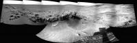
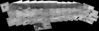
A panoramic view of Larry's Lookout and surrounding seen from Jibsheet.
Pictures taken with the Nav cam on Sol 487. jvandriel
Attached thumbnail(s)
|
|
|
|
|
|
|
May 19 2005, 08:38 PM
Post
#14
|
||
|
Senior Member Group: Members Posts: 2830 Joined: 22-April 05 From: Ridderkerk, Netherlands Member No.: 353 |
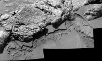
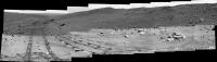
And a view of the other side of Larry's lookout also taken with the Nav cam on sol 488.
jvandriel
Attached thumbnail(s)
|
|
|
|
|
|
| Guest_Edward Schmitz_* |
May 20 2005, 02:53 AM
Post
#15
|
|
Guests |
QUOTE (mhoward @ May 18 2005, 12:13 PM) QUOTE (Sunspot @ May 18 2005, 06:40 PM) I thought it looked like a thin/harder crust on top of the dune had slid down slightly. Another view: http://nasa.exploratorium.edu/mars/spirit/...E0P0123L0M1.JPG I was wondering about weather spirit had been up there previously. But it realy doesn't look like it. I haven't seen anthing to indicate that it was. It doesn't look like it happens alot. I haven't seen anything that looks like old slides. It might be rare and we got lucky. Strange that it seems crusty. That would indicate that the grains were not active. The slope is static since it was cemented. Anybody have any insights... ? |
|
|
|
|
May 20 2005, 03:13 AM
Post
#16
|
|
|
Solar System Cartographer Group: Members Posts: 10163 Joined: 5-April 05 From: Canada Member No.: 227 |
Regarding that weird little slope failure thingy on the south side of Larry's lookout/Watchtower: During the Viking 1 mission there were two events like that, not seen as clearly, but in hindsight very similar indeed to this. Both of them happened during the mission so there were before and after shots. Both on similar steep drift slopes and the best seen one clearly showing a slipped surface layer like this. I don't have my stuff with me as I write this, but it would be easy to track down, it was widely reported.
Phil -------------------- ... because the Solar System ain't gonna map itself.
Also to be found posting similar content on https://mastodon.social/@PhilStooke Maps for download (free PD: https://upload.wikimedia.org/wikipedia/comm...Cartography.pdf NOTE: everything created by me which I post on UMSF is considered to be in the public domain (NOT CC, public domain) |
|
|
|
|
May 20 2005, 04:22 AM
Post
#17
|
|
 Senior Member Group: Members Posts: 1281 Joined: 18-December 04 From: San Diego, CA Member No.: 124 |
Tonight at her talk at JPL (of which I only caught the tail end on NASA TV...curse you inaccurate satellite listings!), Joy Crisp mentioned the slip feature and seemed to imply that the team thinks that ratting earlier caused the disturbance. She even used the word "Duh!" to describe the reaction after they first noticed it.
-------------------- Lyford Rome
"Zis is not nuts, zis is super-nuts!" Mathematician Richard Courant on viewing an Orion test |
|
|
|
|
May 20 2005, 08:03 AM
Post
#18
|
||
 Senior Member Group: Members Posts: 2228 Joined: 1-December 04 From: Marble Falls, Texas, USA Member No.: 116 |
Yeah. I missed her lecture, too. Had to work late. It will be repeated on Friday, but it is not clear whether that will be broadcasted or webcasted again.
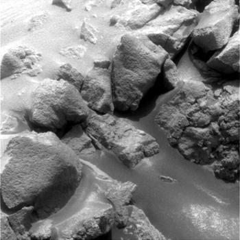
The sediment in this location is piled up quite steeply and is probablly very close to, if not greater than the expected angle of repose, which is about 35 degrees for normal sediments on earth. I'm not certain if that angle would be different on Mars, but this slope is clearly very steep. http://quest.arc.nasa.gov/mars/ask/soil/Di...Mars_soils_.txt If it is an over-steepened slope, somewhat stabilized by weak cementation of the grains by precipitated salts or a slight amount of moisture, the slump was probably just waiting to happen. We may have simply been lucky to have noticed it. But, as Edward has pointed out, we really haven't seen anything that looks like old slumps/slides. As simple as it is, this really is an interesting feature. The fact that it is visible in images taken quite a few sols ago from a distance makes it difficult to imagine it could have been caused by Sprit's activity/ratting. (Tman spotted it as far back as the sol 438 navcams.) I can imagine it could have been caused by a gust of wind, a loud sound, or a slight seismic vibration. On Sol 489 a series of pancams were taken of this area. Here is a portion of it that shows the upper part of the slope failure.
Attached thumbnail(s)
-------------------- ...Tom
I'm not a Space Fan, I'm a Space Exploration Enthusiast. |
|
|
|
|
|
|
May 20 2005, 08:56 AM
Post
#19
|
||
|
Senior Member Group: Members Posts: 2830 Joined: 22-April 05 From: Ridderkerk, Netherlands Member No.: 353 |
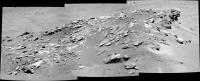
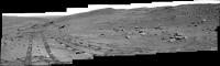
A panoramic view of the top of Larry's Lookout through the eye of the Pancam and L7 filter of Spirit.
Photo's taken on Sol 488. jvandriel
Attached thumbnail(s)
|
|
|
|
|
|
|
May 20 2005, 03:51 PM
Post
#20
|
|
|
Member Group: Members Posts: 700 Joined: 3-December 04 From: Boulder, Colorado, USA Member No.: 117 |
QUOTE (CosmicRocker @ May 20 2005, 08:03 AM) The fact that it is visible in images taken quite a few sols ago from a distance makes it difficult to imagine it could have been caused by Sprit's activity/ratting. (Tman spotted it as far back as the sol 438 navcams.) I can imagine it could have been caused by a gust of wind, a loud sound, or a slight seismic vibration. As I suggested earlier, the slump could have been caused by the ratting on the other side of Larry's Lookout, which was done on sol 416, before there were any images of this slope. |
|
|
|
|
May 20 2005, 05:17 PM
Post
#21
|
|
|
Solar System Cartographer Group: Members Posts: 10163 Joined: 5-April 05 From: Canada Member No.: 227 |
I don't really think the RAT caused the slump feature. The ratting is a fairly gentle process (and was it only brushing anyway?... can't recall now, but they are limiting the RAT use as it wears out) - and it was quite a distance away from this spot, not right on top of it. And the Viking examples which I mentioned above suggest to me that it's not really so unusual. (see page 38, "The Martian Landscape" , NASA SP-425, for the first and best-seen Viking example).
Phil -------------------- ... because the Solar System ain't gonna map itself.
Also to be found posting similar content on https://mastodon.social/@PhilStooke Maps for download (free PD: https://upload.wikimedia.org/wikipedia/comm...Cartography.pdf NOTE: everything created by me which I post on UMSF is considered to be in the public domain (NOT CC, public domain) |
|
|
|
|
May 20 2005, 05:51 PM
Post
#22
|
|
 Newbie Group: Members Posts: 16 Joined: 3-May 05 Member No.: 374 |
QUOTE (CosmicRocker @ May 20 2005, 04:03 AM) ....On Sol 489 a series of pancams were taken of this area. Here is a portion of it that shows the upper part of the slope failure. Can anyone comment on how the surface materials in these drifts are bonded into plates? |
|
|
|
|
May 20 2005, 06:06 PM
Post
#23
|
|
|
Senior Member Group: Members Posts: 2228 Joined: 1-December 04 From: Marble Falls, Texas, USA Member No.: 116 |
Well, this new hazcam shot really turns my "slump was probably just waiting to happen" hypothesis upside down. If the dust on that slope was so sensitive to vibrations, I suspect Spirit wouldn't have gotten this close without disturbing it further.
http://qt.exploratorium.edu/mars/spirit/fo...EEP1214L0M1.JPG -------------------- ...Tom
I'm not a Space Fan, I'm a Space Exploration Enthusiast. |
|
|
|
|
May 20 2005, 07:32 PM
Post
#24
|
|
|
Senior Member Group: Moderator Posts: 3431 Joined: 11-August 04 From: USA Member No.: 98 |
Some color (sorry, I don't have time to stitch them together):
    
|
|
|
|
|
May 20 2005, 08:40 PM
Post
#25
|
|
|
Member Group: Members Posts: 700 Joined: 3-December 04 From: Boulder, Colorado, USA Member No.: 117 |
QUOTE (Phil Stooke @ May 20 2005, 05:17 PM) I don't really think the RAT caused the slump feature. The ratting is a fairly gentle process (and was it only brushing anyway?... can't recall now, but they are limiting the RAT use as it wears out) - and it was quite a distance away from this spot, not right on top of it. And the Viking examples which I mentioned above suggest to me that it's not really so unusual. (see page 38, "The Martian Landscape" , NASA SP-425, for the first and best-seen Viking example). Phil I admit it seems unlikely that ratting the other side of the outcrop would cause this slump (they did grind, not just brush, on Larry's Lookout -see Sol 419 Hazcam image). And I remember the Viking 1 slumps, at least one of which was far enough from the lander that the lander can't reasonably have caused it. I'm just struck by how this looks *so* fresh, and how I can't recall seeing any examples of more degraded slumps previously. It is striking that Spirit's wheels digging into the slope have not precipitated further slumping, though maybe the slope is more susceptible to failure by a push from behind than by digging from below. |
|
|
|
|
May 20 2005, 10:19 PM
Post
#26
|
|
 Chief Assistant Group: Admin Posts: 1409 Joined: 5-January 05 From: Ierapetra, Greece Member No.: 136 |
Here's a pancam mosaic of four of the images posted by Mhoward. I'm waiting for the other frames with missing data to update, hopefully.
 Very intriguing this feature. Cheers Nico awalkonmars new Spirit sol 489 -------------------- photographer, space imagery enthusiast, proud father and partner, and geek.
http://500px.com/sacred-photons & |
|
|
|
|
May 21 2005, 01:27 AM
Post
#27
|
|
|
Senior Member Group: Members Posts: 2998 Joined: 30-October 04 Member No.: 105 |
QUOTE (CosmicRocker @ May 20 2005, 12:06 PM) Well, this new hazcam shot really turns my "slump was probably just waiting to happen" hypothesis upside down. If the dust on that slope was so sensitive to vibrations, I suspect Spirit wouldn't have gotten this close without disturbing it further. http://qt.exploratorium.edu/mars/spirit/fo...EEP1214L0M1.JPG The Crusty unit does appear to be thicker and more coherent than the adjacent areas. After detailed MI, she should give this unit a poke and see what it does. It is clearly aeolian, and my guess is that it contains a hygroscopic salt that is cemented with the humour of atmosphaeric moysture...  --Bill -------------------- |
|
|
|
|
May 21 2005, 01:35 PM
Post
#28
|
|
 Senior Member Group: Members Posts: 2488 Joined: 17-April 05 From: Glasgow, Scotland, UK Member No.: 239 |
I agree regarding the slumped material. The platy layers look like a caliche style of cemented deposit, and perhaps the hygroscopic salt hypothesis is the right one. This sort of deposit has been seen right back to Viking 1, though the salt-rich soil is a new bit of the jigsaw!
-------------------- Remember: Time Flies like the wind - but Fruit Flies like bananas!
|
|
|
|
|
May 21 2005, 02:09 PM
Post
#29
|
|
|
Member Group: Members Posts: 477 Joined: 2-March 05 Member No.: 180 |
QUOTE (Bob Shaw @ May 21 2005, 09:35 AM) I agree regarding the slumped material. The platy layers look like a caliche style of cemented deposit, and perhaps the hygroscopic salt hypothesis is the right one. This sort of deposit has been seen right back to Viking 1, though the salt-rich soil is a new bit of the jigsaw! Well, given that they've gotten right up close to the slump, I imagine that a little brushing with the RAT might be in order. That should be more than adequate to have a look at all the layers, as well as maybe trigger additional landslides. |
|
|
|
|
May 21 2005, 03:33 PM
Post
#30
|
|
|
Member Group: Members Posts: 877 Joined: 7-March 05 From: Switzerland Member No.: 186 |
How about season, alternatively sun dont reached this slope over wintertime?! And now in the actual season the slope get warmness and this has activated "anything" or caused layers in the sandy soil at least?!
-------------------- |
|
|
|
|
May 21 2005, 03:39 PM
Post
#31
|
|
|
Member Group: Members Posts: 320 Joined: 19-June 04 Member No.: 85 |
Yes, I also agree that it's a hardened layer of duricrust that was disturbed in some way by the rover. Duritcrust was previously observed at Opportunity, Pathfinder and Viking landing sites.
http://marsrovers.jpl.nasa.gov/gallery/all...03P2584L7M1.JPG This paper describes the process involved and you can also read a summary on my site under the "Duricrust" heading. http://www.lpi.usra.edu/meetings/lpsc2004/pdf/2188.pdf Cheers, Aldo. -------------------- |
|
|
|
|
May 21 2005, 08:47 PM
Post
#32
|
|
|
Senior Member Group: Members Posts: 2488 Joined: 17-April 05 From: Glasgow, Scotland, UK Member No.: 239 |
The paper on the duricrust posits some very credible processes, and when one considers the Viking 2 images of hoar frost at the landing site then a ready source of water is apparant.
I'm reminded of the 'mineralisation' process which occurs in sandstone used for buildings (a big chunk of Glasgow, where I live, is built of Old Red Sandstone from the north-west of Scotland) and which often preserves 400 MYO bedding planes etc in the facades of houses. I wonder whether the aeon-long formation of duricrust would eventually give us rocks comparable to terrestrial sandstone, or whether it would always remain rather more friable and delicate? The exhumation of buried features we see from orbital imagery suggests that there are episodes of harder/softer rock deposition, which may be linked to relative abundance of water (eg a nice big impact could create a briefly wet Mars with well mineralised rocks, with a gradual return to the fairy-cake stuff as time wears on). Ah, the ghost of Tommy Gold beckons! -------------------- Remember: Time Flies like the wind - but Fruit Flies like bananas!
|
|
|
|
|
May 21 2005, 10:50 PM
Post
#33
|
|
 Senior Member Group: Members Posts: 2492 Joined: 15-January 05 From: center Italy Member No.: 150 |
QUOTE (NIX @ May 20 2005, 10:19 PM) Here's a pancam mosaic of four of the images posted by Mhoward. I'm waiting for the other frames with missing data to update, hopefully. Very intriguing this feature. Cheers Nico awalkonmars new Spirit sol 489 Nico, missing (right) portion in the next Sol:  Regards. -------------------- I always think before posting! - Marco -
|
|
|
|
|
May 22 2005, 06:16 AM
Post
#34
|
|
|
Senior Member Group: Members Posts: 2228 Joined: 1-December 04 From: Marble Falls, Texas, USA Member No.: 116 |
QUOTE (Bob Shaw @ May 21 2005, 02:47 PM) ... Ah, the ghost of Tommy Gold beckons! Shiver me timbers! Are you suggesting we'll eventually be drilling impact sites on Mars to harvest hydrocarbons? -------------------- ...Tom
I'm not a Space Fan, I'm a Space Exploration Enthusiast. |
|
|
|
|
May 22 2005, 07:29 AM
Post
#35
|
|
|
Senior Member Group: Members Posts: 2228 Joined: 1-December 04 From: Marble Falls, Texas, USA Member No.: 116 |
Sorry this is long, but I found myself on a roll...
 It definitely seems to be a "crusty unit," but going so far as to call it a "duricrust" seems unwarranted. I really haven't yet seen anything I'd call a true duricrust on Mars. I really prefer the "weakly cemented by salts" hypothesis. Water ice is a second choice for me. There were a few images from around sol 110 taken near Endurance that keep popping up as examples of duricrust, but taken in the context of the surroundings, they appear to me to be soil/dust covered slabs of fractured bedrock that were disturbed by Oppy's wheels. Purported examples of duricrust: http://marsrovers.jpl.nasa.gov/gallery/all...03P2584L7M1.JPG http://www.lyle.org/~markoff/pds/234567/1P...87L234567C1.JPG Context images showing the dust/soil covered plates of broken-up bedrock surrounding Endurance crater: http://marsrovers.jpl.nasa.gov/gallery/all...3P2366L7M1.HTML http://marsrovers.jpl.nasa.gov/gallery/all...3P2366L7M1.HTML http://www.lyle.org/~markoff/pds/257/1P137...P2361L257C1.JPG These are some that have been partially exhumed: http://www.lyle.org/~markoff/pds/257/1P138...P2295L257C1.JPG http://www.lyle.org/~markoff/pds/257/1P138...P2295L257C1.JPG -------------------- ...Tom
I'm not a Space Fan, I'm a Space Exploration Enthusiast. |
|
|
|
|
May 22 2005, 12:25 PM
Post
#36
|
|
|
Senior Member Group: Members Posts: 2488 Joined: 17-April 05 From: Glasgow, Scotland, UK Member No.: 239 |
The 'Tommy Gold' reference was more in regard to his ability to think out of the box - a bit like Fred Hoyle. A lot of their ideas didn't pan out, but they were always interesting!
And as for the cosmic origins for hydrocarbons hypothesis, well it seems unlikely at first glance but... -------------------- Remember: Time Flies like the wind - but Fruit Flies like bananas!
|
|
|
|
|
May 22 2005, 06:39 PM
Post
#37
|
|
 Senior Member Group: Members Posts: 3419 Joined: 9-February 04 From: Minneapolis, MN, USA Member No.: 15 |
QUOTE (CosmicRocker @ May 22 2005, 02:29 AM) It definitely seems to be a "crusty unit," but going so far as to call it a "duricrust" seems unwarranted. I really haven't yet seen anything I'd call a true duricrust on Mars. I really prefer the "weakly cemented by salts" hypothesis. Water ice is a second choice for me. "Duricrust" is a term that was applied to some Viking soils back in the 1970s, to describe the cohesive properties of the upper few mm of some of the soils. As far as I've ever been able to tell, it's used in a descriptive, not a diagnostic, manner -- it describes the cohesive qualities of some top layers of Martian soils. It doesn't pre-suppose a reason for the cohesiveness, i.e., it doesn't assume that the duricrust is created by a permafrost layer or anything like that. (So the idea of an absolute "true duricrust" doesn't really enter the discussion, I don't think.) In fact, the conclusion of the original Viking team was that the duricrust is likely a weakly cemented unit resulting from evaporation of salts from groundwater. Since no evidence of current groundwater was returned, they didn't state that assumption as certain, but I know it was the preferred theory for the observed phenomenon. -the other Doug -------------------- The trouble ain't that there is too many fools, but that the lightning ain't distributed right. -Mark Twain
|
|
|
|
|
May 22 2005, 06:54 PM
Post
#38
|
|
|
Senior Member Group: Members Posts: 3419 Joined: 9-February 04 From: Minneapolis, MN, USA Member No.: 15 |
QUOTE (Bob Shaw @ May 22 2005, 07:25 AM) The 'Tommy Gold' reference was more in regard to his ability to think out of the box - a bit like Fred Hoyle. A lot of their ideas didn't pan out, but they were always interesting! Tommy Gold's problem wasn't that he thought outside of the box (which claim I question just a bit) -- it was that, in the face of overwhelming evidence that his theory was invalid, he not only stuck to it, he got louder and more shrill about it right up to the point where men actually walked on the Moon. Face it -- after two successful Luna and five successful Surveyor landings proved that the lunar regolith was sturdy enough to support all sorts of weight, the man was still strongly (and publicly) pressuring NASA to include a set of large weights with brightly colored flags attached that were to be shot out in front of the LM as it descended, to make *absolutely sure* that the surrface below wasn't a meters-deep quagmire of lunar quicksand. "Thinking outside the box" is no excuse for vociferously hanging on to theories that have been discredited. -the other Doug -------------------- The trouble ain't that there is too many fools, but that the lightning ain't distributed right. -Mark Twain
|
|
|
|
|
May 22 2005, 07:38 PM
Post
#39
|
|
|
Senior Member Group: Members Posts: 2488 Joined: 17-April 05 From: Glasgow, Scotland, UK Member No.: 239 |
But a flag-draped LM would have been *entertaining* at the very least!
-------------------- Remember: Time Flies like the wind - but Fruit Flies like bananas!
|
|
|
|
|
May 23 2005, 03:36 AM
Post
#40
|
|
|
Senior Member Group: Members Posts: 2228 Joined: 1-December 04 From: Marble Falls, Texas, USA Member No.: 116 |
QUOTE (dvandorn @ May 22 2005, 12:39 PM) "Duricrust" is a term that was applied to some Viking soils back in the 1970s, to describe the cohesive properties of the upper few mm of some of the soils. As far as I've ever been able to tell, it's used in a descriptive, not a diagnostic, manner -- it describes the cohesive qualities of some top layers of Martian soils. It doesn't pre-suppose a reason for the cohesiveness, i.e., it doesn't assume that the duricrust is created by a permafrost layer or anything like that. (So the idea of an absolute "true duricrust" doesn't really enter the discussion, I don't think.) In fact, the conclusion of the original Viking team was that the duricrust is likely a weakly cemented unit resulting from evaporation of salts from groundwater. Since no evidence of current groundwater was returned, they didn't state that assumption as certain, but I know it was the preferred theory for the observed phenomenon. -the other Doug I know that the term had been used for similarly caked soils observed by a Viking misssion, and even by many other scientists studying other parts of Mars over the years. All I am saying is, it that it's a misuse of the term. Duricrust is a useful geologic term which has a much longer history than that of the space program. While the definition is fairly broad and open to some interpretation, it has always implied an indurated, strongly to moderately cemented soil or regolithic material. Ie, it is literally as hard as a rock, and therefore has the ability to control the later geomorphic evolution of the landscape. Laterites, bauxites,ferricretes, silcretes, even caliches are classic duricrusts. Apparently most of us agree that whatever we call it, this looks like some kind of a salt-caked crust. I don't want to debate semantics. It's just that I hate definition-creep, especially when it erodes the value of a time-worn and useful term. -------------------- ...Tom
I'm not a Space Fan, I'm a Space Exploration Enthusiast. |
|
|
|
|
May 23 2005, 04:43 AM
Post
#41
|
|
|
Senior Member Group: Members Posts: 1870 Joined: 20-February 05 Member No.: 174 |
Tommy Gold and Fred Hoyle were similar "theory testing impaired"
They were wrong a lot of the time. They had tremendous abilities to sort through and select and interpret evidence in support of their theories and ignore evidence that blew their theories out of the water entirely. Much of the science they did in their later years bordered on or went over the border into crackpottery. But when they were right, they were spectacularly right. Their theories were always worth listening to, and thinking about, even when you were 99.9% sure they were totally off--the--wall wrong |
|
|
|
|
May 23 2005, 05:29 AM
Post
#42
|
|
|
Senior Member Group: Members Posts: 2228 Joined: 1-December 04 From: Marble Falls, Texas, USA Member No.: 116 |
When I saw this front hazcam today I initially thought we would see MIs of the crust, but it's clear they are looking at the rock above.
http://qt.exploratorium.edu/mars/spirit/fo...EEP1131L0M1.JPG Here is a mosaic of the MIs from today.  The clasts in this rock seem to me to be more angular than some of the other outcrops we've been seeing as we came up the hill. Looking at the pancams from Larry's outcrop I am wondering if I am seeing some evidence of graded bedding. Does anyone else see that? Finally, back to the crust. It appears to me that this image captured evidence of some other, partially eroded, crusty dust in the upper right. http://qt.exploratorium.edu/mars/spirit/pa...EEP2535L7M1.JPG -------------------- ...Tom
I'm not a Space Fan, I'm a Space Exploration Enthusiast. |
|
|
|
|
May 23 2005, 03:29 PM
Post
#43
|
|
 Member Group: Members Posts: 103 Joined: 12-February 05 From: Utah Member No.: 167 |
Seeing some of the microscopic images from Spirit last night reminded me a little bit of the images Oppy took at El Capitan and other outcrops in Eagle Crater. Is this going to turn into press conference material??
-------------------- - My signature idea machine is busted right now.
|
|
|
|
|
May 23 2005, 04:14 PM
Post
#44
|
|
|
Senior Member Group: Moderator Posts: 3431 Joined: 11-August 04 From: USA Member No.: 98 |
QUOTE (Bubbinski @ May 23 2005, 03:29 PM) Seeing some of the microscopic images from Spirit last night reminded me a little bit of the images Oppy took at El Capitan and other outcrops in Eagle Crater. Is this going to turn into press conference material?? I had the same question. And there seem to be lower levels of outcrop available to look at if they're feeling lucky... I can't wait to see what those look like. |
|
|
|
| Guest_Sunspot_* |
May 23 2005, 04:38 PM
Post
#45
|
|
Guests |
I had exactly the same thought when I saw these latest MI pics. One in particular stood out:
http://qt.exploratorium.edu/mars/spirit/mi...EEP2957M2M1.JPG Look towards the right of the image, say about 80% of the way towards the right edge, and just over half way down. It looks like a "blueberry" encased in rock. |
|
|
|
|
May 24 2005, 02:04 AM
Post
#46
|
|
|
Member Group: Members Posts: 233 Joined: 21-April 05 Member No.: 328 |
I'm with you, gentlemen, this stuff DOES look like Meridiani, both up close and from a distance. I started a thread on this topic some weeks ago ("Spirit Hits Blueberries" -- you can find it via the "Search Forum" feature), and there was an initial flurry of interest -- but NASA/JPL/Cornell has not been very definitive about what they are finding. But maybe the stage is being set anew.
On the other hand, I have to keep reminding myself that the exposed surfaces we are seeing are the result of perhaps hundreds of millions of years of weathering via wind driven sand, dust devils, etc., so perhaps this TENDS to create a characteristic-looking surface regardless of the actual composition of the rock. I mean, imagine taking your beloved rock collection, sandblasting it for a couple of hours, and then trying to figure out what's what. But darn, this Larry's Lookout stuff does have the same "ropey" appearance as the stuff Oppy has been seeing thougout! Glenn |
|
|
|
|
May 24 2005, 05:25 AM
Post
#47
|
|
|
Senior Member Group: Members Posts: 2228 Joined: 1-December 04 From: Marble Falls, Texas, USA Member No.: 116 |
OK. I can appreciate that there are certain similarities among MI images taken of rocks by both rovers. But both rovers are commanded by people looking for layered rocks, and all of those rocks are presented to us microscopically as grayscale images.
The devil is in the details of the rock texture; the grain size/shape/orientation distributions. I think the rock compositions from spectral data is quite different also, but I don't have links to that at my fingertips. The MIs of the rocks from Eagle crater look very different to me from the latest MIs of Larry's outcrop. There are so many images from Opportunity that one might compare these rocks to, but I chose a few from some press conferences and put them into a crude montage with the recent mosaic from Spirit. 
-------------------- ...Tom
I'm not a Space Fan, I'm a Space Exploration Enthusiast. |
|
|
|
|
May 24 2005, 05:14 PM
Post
#48
|
|
 Member Group: Members Posts: 270 Joined: 29-December 04 From: NLA0: Member No.: 133 |
The full six frame mosaic sol 489:
http://paranoid.dechengst.nl/mars/Larry%20Lookout.jpg Color needs correction though and Photoshop drives me crazy with all the options  Anyone willing to write a nice tutorial ? Anyone willing to write a nice tutorial ?
-------------------- PDP, VAX and Alpha fanatic ; HP-Compaq is the Satan! ; Let us pray daily while facing Maynard! ; Life starts at 150 km/h ;
|
|
|
|
|
May 24 2005, 06:49 PM
Post
#49
|
|
|
Senior Member Group: Members Posts: 1281 Joined: 18-December 04 From: San Diego, CA Member No.: 124 |
QUOTE (DEChengst @ May 24 2005, 09:14 AM) Color needs correction though and Photoshop drives me crazy with all the options Anyone willing to write a nice tutorial ? I have a better link in my bookmarks at home but this guy seems to have written a decent overview and there is a motherlode of tutorial links here. You can also get stuff on the adobe site, but it requires registration. I'll post more in the imagery forum later, if I remember I have an "on again - off again-love-hate" relationship with photoshop.... -------------------- Lyford Rome
"Zis is not nuts, zis is super-nuts!" Mathematician Richard Courant on viewing an Orion test |
|
|
|
|
May 25 2005, 01:33 AM
Post
#50
|
|
|
Newbie Group: Members Posts: 16 Joined: 3-May 05 Member No.: 374 |
 My first impression here was that I was looking at mud. The surface appears smoother, more reflective, perhaps finer grains collecting in a sheltered location? 
|
|
|
|
|
May 25 2005, 02:05 AM
Post
#51
|
|
|
Senior Member Group: Members Posts: 2998 Joined: 30-October 04 Member No.: 105 |
QUOTE My first impression here was that I was looking at mud. Mars does that to you.  I had a similar first impression with deposits of "hematite silt" from Oppy at Burns Cliff. Sometimes the windblown surfaces look quite water-borne. We live in an aqueous environment and many times, past experience colors our perceptions. Things are not always as they seem. --Bill -------------------- |
|
|
|
|
May 25 2005, 05:08 AM
Post
#52
|
|
|
Senior Member Group: Members Posts: 2228 Joined: 1-December 04 From: Marble Falls, Texas, USA Member No.: 116 |
We received some MIs of the broken crust today. I made a small mosaic from them.
 I have been wondering about these light patches seen in the pancams of the area. The fine grained, light areas in the MIs are certainly consistent with a major concentration of salts. -------------------- ...Tom
I'm not a Space Fan, I'm a Space Exploration Enthusiast. |
|
|
|
|
May 25 2005, 11:04 AM
Post
#53
|
|
|
Senior Member Group: Members Posts: 2998 Joined: 30-October 04 Member No.: 105 |
Good mosaic.
I've see something like this locally. If a mine has pyritic material in the overburden, this material weathers into iron, sulfate (salts) and acid. This mineralized water saturates loose sand or porous sandstone, evaporates and leaves behind what is called a "sulfate bloom" on the surface. Of added interest is the bright, overexposed "CCD bleed" in the top row of MI images used in the mosaic. This suggests to me a fresh, reflective crystal face (well, "object"; crystal has a new-age loaded meaning) on the surface. --Bill -------------------- |
|
|
|
|
May 26 2005, 04:27 AM
Post
#54
|
|
|
Senior Member Group: Members Posts: 2228 Joined: 1-December 04 From: Marble Falls, Texas, USA Member No.: 116 |
Bill:
I have seen similar things as well in sulfide rich sediments that were exposed to oxidation. I see the similarity. I also noticed that CCD bleed, but didn't stop to think about it. You could very well be correct. I found another MI of the same area without the flare, but it was somewhat out of focus. There was still an indistinct bright area at that same location. Scanning other images of this stuff, I can see some grains that suggest a cubic or rhombic outline, and one or two of them that have what might be a crystal face that is saturated in luminosity. It appears as if they have backed away from this site without using any of the other instruments on the arm. I would have liked to have seen more of an investigation, but perhaps they already know what they were looking at. -------------------- ...Tom
I'm not a Space Fan, I'm a Space Exploration Enthusiast. |
|
|
|
|
May 26 2005, 06:04 AM
Post
#55
|
|
|
Senior Member Group: Members Posts: 2492 Joined: 15-January 05 From: center Italy Member No.: 150 |
Here a super resolution outcrop image (sum of 8 PanCam frames from Sol494):

-------------------- I always think before posting! - Marco -
|
|
|
|
|
May 26 2005, 02:09 PM
Post
#56
|
|
|
Senior Member Group: Members Posts: 2998 Joined: 30-October 04 Member No.: 105 |
The specular reflection was so unusual on dusty, wind-eroded Mars that it was _very_ noticable. Hopefully, someone in the back room noticed it too and got more MIs.
--Bill -------------------- |
|
|
|
|
May 28 2005, 06:31 PM
Post
#57
|
|
|
Senior Member Group: Members Posts: 2228 Joined: 1-December 04 From: Marble Falls, Texas, USA Member No.: 116 |
Steve Squyres has a new update today, with a lot of discussion of these rocks.
http://athena1.cornell.edu/news/mubss/ I was actually thinking of posting a message here today arguing for an impact origin of these rocks, but Steve says they favor a volcaniclastic origin. He also has some interesting discussion of the distribution of alteration they have observed. Apparently they have seen some pretty significant alteration, even at the top of the section. -------------------- ...Tom
I'm not a Space Fan, I'm a Space Exploration Enthusiast. |
|
|
|
|
May 29 2005, 06:43 AM
Post
#58
|
|
 Member Group: Members Posts: 118 Joined: 14-March 05 Member No.: 195 |
QUOTE (CosmicRocker @ May 26 2005, 04:27 AM) Bill: I have seen similar things as well in sulfide rich sediments that were exposed to oxidation. I see the similarity. I also noticed that CCD bleed, but didn't stop to think about it. You could very well be correct. I found another MI of the same area without the flare, but it was somewhat out of focus. There was still an indistinct bright area at that same location. Scanning other images of this stuff, I can see some grains that suggest a cubic or rhombic outline, and one or two of them that have what might be a crystal face that is saturated in luminosity. It appears as if they have backed away from this site without using any of the other instruments on the arm. I would have liked to have seen more of an investigation, but perhaps they already know what they were looking at. Oh man, would this be a micromounters wet dream or what..  ...........minerals in crystal form from Mars.....oh yah.... ...........minerals in crystal form from Mars.....oh yah.... so care to guess what mineral it is composed of? Scott |
|
|
|
|
May 31 2005, 01:49 AM
Post
#59
|
|
|
Senior Member Group: Members Posts: 2228 Joined: 1-December 04 From: Marble Falls, Texas, USA Member No.: 116 |
QUOTE (wyogold @ May 29 2005, 12:43 AM) Oh man, would this be a micromounters wet dream or what.. ...........minerals in crystal form from Mars.....oh yah.... so care to guess what mineral it is composed of? Scott Oh, yeah. I wouldn't mind having a few of those micromounts...one for my collection, and the others for sale on Ebay. If that really was a crystal gleaming in the sunlight, I'd hesitate to guess what it was. There are so many possibilities. Small crystals are relatively common in soils and sediments on Earth, and I see no reason the same shouldn't be true on Mars. I'm actually somewhat surprized we haven't seen more examples of this. -------------------- ...Tom
I'm not a Space Fan, I'm a Space Exploration Enthusiast. |
|
|
|
|
May 31 2005, 02:33 AM
Post
#60
|
|
|
Senior Member Group: Members Posts: 2228 Joined: 1-December 04 From: Marble Falls, Texas, USA Member No.: 116 |
I noticed an interesting pancam sequence captured on sols 497-498, and managed to convince Autostitch to combine all 28 images into this panorama.
 It's interesting to see the crisscrossing pattern of tracks here, and further down the hill. It gives one a sense of how carefully they are investigating the rocks in this area. Like a good field geologist, Spirit's been all over these outcrops. I had to shrink the original 33 MB image down to 1 MB to post this, but I don't think it lost too much detail. -------------------- ...Tom
I'm not a Space Fan, I'm a Space Exploration Enthusiast. |
|
|
|
|
Jun 2 2005, 07:25 AM
Post
#61
|
|
|
Senior Member Group: Members Posts: 2492 Joined: 15-January 05 From: center Italy Member No.: 150 |
This is a color stitch from Sol497 (only the left portion of CosmicRocker mosaic...):
 Notes: L257 pseudo colors, 50% of original scale, made with autostich. -------------------- I always think before posting! - Marco -
|
|
|
|
|
Jun 2 2005, 11:49 AM
Post
#62
|
|
|
Member Group: Members Posts: 877 Joined: 7-March 05 From: Switzerland Member No.: 186 |
Thanks, your pans show the first time Spirit's whole path uphill. Sadly we should have a Rover 3D model available on the web in order to fit it into such great pans. That would be concrete.
A 3D model like this would already satisfy: http://www.br-online.de//wissen-bildung/th...lash-rover.html It must be copyable in each position. This post has been edited by Tman: Jun 2 2005, 04:45 PM -------------------- |
|
|
|
|
Jun 2 2005, 07:04 PM
Post
#63
|
||
|
Solar System Cartographer Group: Members Posts: 10163 Joined: 5-April 05 From: Canada Member No.: 227 |
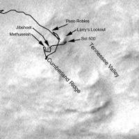
This is a simple sketch map of the recent travels of Spirit, superimposed on the best MOC image of the area.
Phil -------------------- ... because the Solar System ain't gonna map itself.
Also to be found posting similar content on https://mastodon.social/@PhilStooke Maps for download (free PD: https://upload.wikimedia.org/wikipedia/comm...Cartography.pdf NOTE: everything created by me which I post on UMSF is considered to be in the public domain (NOT CC, public domain) |
|
|
|
|
|
|
Jun 2 2005, 08:01 PM
Post
#64
|
|
 Member Group: Members Posts: 578 Joined: 5-November 04 From: Denmark Member No.: 107 |
I took the opportunity (no pun) and put the 3d model in the pan
http://img178.echo.cx/my.php?image=sol497p...4gdcopy15ds.jpg http://img178.echo.cx/my.php?image=sol497p...l4gdcopy3yu.jpg Great idea 
-------------------- "I want to make as many people as possible feel like they are part of this adventure. We are going to give everybody a sense of what exploring the surface of another world is really like"
- Steven Squyres |
|
|
|
|
Jun 2 2005, 08:20 PM
Post
#65
|
|
|
Member Group: Members Posts: 877 Joined: 7-March 05 From: Switzerland Member No.: 186 |
That's exactly what I was hoping for, but never thought that it could... Hey, it seems you have the right tool for the journey If you eventually may to put each view on your image host, little by little, I would not say no But we should consider that this flash has a copyright! How could we manage this? This post has been edited by Tman: Jun 2 2005, 08:35 PM -------------------- |
|
|
|
|
Jun 2 2005, 08:25 PM
Post
#66
|
|
|
Senior Member Group: Members Posts: 2998 Joined: 30-October 04 Member No.: 105 |
QUOTE I took the opportunity (no pun) and put the 3d model in the pan Thanks, that certainly puts things into perspective... --Bill -------------------- |
|
|
|
|
Jun 3 2005, 04:49 AM
Post
#67
|
|
|
Senior Member Group: Members Posts: 2492 Joined: 15-January 05 From: center Italy Member No.: 150 |
Wonderful!
Good idea from Tman and great application from dot.dk! (I love this Forum  ). ).Hey guys, this could be the last view from Larry's lookout! (Autostitch of 2 NavCam from Sol503): 
-------------------- I always think before posting! - Marco -
|
|
|
|
|
Jun 3 2005, 11:33 PM
Post
#68
|
|
|
Senior Member Group: Members Posts: 2492 Joined: 15-January 05 From: center Italy Member No.: 150 |
A larger version:
 Tman/Nirgal, do you think could be a nice starting material for you...?
-------------------- I always think before posting! - Marco -
|
|
|
|
|
Jun 4 2005, 07:31 AM
Post
#69
|
|
|
Member Group: Members Posts: 877 Joined: 7-March 05 From: Switzerland Member No.: 186 |
Could be dilo, could be
But it seems to me there is to much traffic for a neat photography of nature Wow, three different old tracks from Spirit in the sand and we were already there: http://www.greuti.ch/spirit/nav-sol438b.jpg (new version of March 29) It seems Spirit loves this position. -------------------- |
|
|
|
|
Jun 4 2005, 02:35 PM
Post
#70
|
||
|
Senior Member Group: Members Posts: 2830 Joined: 22-April 05 From: Ridderkerk, Netherlands Member No.: 353 |
Spirit again on its way to the summit of Husband Hill.
Looking back to Jibsheet and Larry's Lookout and seeing all the tracks he made. Here is the panorama of that view made on Sol 503 through the R Navcam. jvandriel
Attached thumbnail(s)
|
|
|
|
|
|
|
Jun 5 2005, 08:51 PM
Post
#71
|
|
|
Senior Member Group: Members Posts: 2492 Joined: 15-January 05 From: center Italy Member No.: 150 |
from Sol500 (images available only now...):
 If I'm not wrong, this stitch is an interesting Larry's side view! -------------------- I always think before posting! - Marco -
|
|
|
|
| Guest_Myran_* |
Jun 6 2005, 01:12 AM
Post
#72
|
|
Guests |
Wonderful image composites dilo.
Looking at the last image and especially the end of the tracks made me think that the fine dust there might have similar properties (very fine grinded) as the dust Opportunity digged itself down in in Meridiani. So Spirit was lucky there wasnt more of it in that location. (might be a good idea to avoid places where such dust would accumulate like in downwind location etc) |
|
|
|
|
Jun 6 2005, 03:06 PM
Post
#73
|
|
 Member Group: Members Posts: 656 Joined: 20-April 05 From: League City, Texas Member No.: 285 |
Dilo, I like that one a lot ... it's my new desktop background. Thanks
|
|
|
|
|
Jun 6 2005, 07:37 PM
Post
#74
|
|
|
Senior Member Group: Members Posts: 2492 Joined: 15-January 05 From: center Italy Member No.: 150 |
QUOTE (algorimancer @ Jun 6 2005, 03:06 PM) Dilo, I like that one a lot ... it's my new desktop background. Thanks
-------------------- I always think before posting! - Marco -
|
|
|
|
|
Jun 6 2005, 07:50 PM
Post
#75
|
|
|
Solar System Cartographer Group: Members Posts: 10163 Joined: 5-April 05 From: Canada Member No.: 227 |
Yeah, great work!
Phil -------------------- ... because the Solar System ain't gonna map itself.
Also to be found posting similar content on https://mastodon.social/@PhilStooke Maps for download (free PD: https://upload.wikimedia.org/wikipedia/comm...Cartography.pdf NOTE: everything created by me which I post on UMSF is considered to be in the public domain (NOT CC, public domain) |
|
|
|
|
Jun 7 2005, 01:48 AM
Post
#76
|
|
|
Senior Member Group: Members Posts: 2998 Joined: 30-October 04 Member No.: 105 |
Wonderful-- it's my new Wallpaper, too.
What are the current thoughts on what is happening here? There is a cemented crust on the surface and a mobile subsurface. The slide area was interesting enough but the disturbed areas around the wheels are more so. And, unless I'm mistaken, I see a purple-colored subsoil like we saw on the climb up. --Bill -------------------- |
|
|
|
|
Jun 7 2005, 07:49 AM
Post
#77
|
|
|
Senior Member Group: Members Posts: 1870 Joined: 20-February 05 Member No.: 174 |
On Earth, sediment transport processes tend to separate sand sized (1 to 0.1 mm, roughly) sized particles from smaller silt and clay sized particles. (Geologist's operational test to tell siltstone from claystone: nibble a bit between your front teeth. If it's gritty, it's got silt sized particles, if it's smooth, it's all clay sized!) Thus Earth gets lots of relatively well sorted sandstones, and very different silt dominated sediments on land and in rivers. Clay sized dust tends to stay in suspension in the air or rivers and ends up in the oceans as a component of marine oozes.
On Mars, the globally transported dust storm dusts are mostly clay sized... a few microns sized particles, and the dark dunes in craters and the north polar sand seas do appear both visually and from thermal properties to be reasonably well sorted sand grains, but a lot of the stuff the rovers are encountering seem to be a varied assortment of clay/silt/sand and granule (2 mm or so) sized materials, with all sorts of small scale sorting going on, but not making sediments with really well defined average particle sizes. A big reason is the lack of water and it's roles in separating the different materials mechanically, and the lack of oceans to trap the eolian transported dust. A big question polar lander was to help answer and Phoenix will tackle is the nature of high latitude "dust and ice" deposits. The Polar Lander's targets are true polar deposits, it's unclear what the dirty ice (inferred from Odyssey's data) are that Phoenix is targeted for. |
|
|
|
|
Jun 8 2005, 09:54 PM
Post
#78
|
|
|
Senior Member Group: Members Posts: 2492 Joined: 15-January 05 From: center Italy Member No.: 150 |
I integrated part of previous Larry's mosaic with more recent color images from PanCam and identified their location inside a "colorized" Sol507 NavCam stitch:
 As a bonus, in the top/left insert there is also a portion of relatively rare full NavCam picture of a DD from the same day (as you know, most DD appear in subframes images... ).
-------------------- I always think before posting! - Marco -
|
|
|
|
|
Jun 9 2005, 09:34 AM
Post
#79
|
|
|
Senior Member Group: Moderator Posts: 4279 Joined: 19-April 05 From: .br at .es Member No.: 253 |
Beautiful mosaic Dilo.
Great work! I made a pano of Sol 507 too (using autostitch), but your composition beats it by an order of magnitude. Tesheiner |
|
|
|
|
Jun 9 2005, 10:26 AM
Post
#80
|
|
|
Member Group: Members Posts: 713 Joined: 30-March 05 Member No.: 223 |
great work, dilo !
makes me all the more looking forward to the images/mosaics to come with the new terrain we are about to discover in the next weeks
|
|
|
|
|
Jun 9 2005, 02:22 PM
Post
#81
|
|
|
Member Group: Members Posts: 320 Joined: 19-June 04 Member No.: 85 |
Awesome work Dilo! And a great idea pointing out the locations of the different rock targets.
-------------------- |
|
|
|
|
Jun 10 2005, 12:38 PM
Post
#82
|
||
|
Senior Member Group: Members Posts: 2830 Joined: 22-April 05 From: Ridderkerk, Netherlands Member No.: 353 |
Here is a panoramic view of Jibsheet, Gusev Crater and Larry's Lookout taken with the L7 pancam.
The horizon is not perfect but this is the best result from Autostitch. The original view is 21 MB. made from 48 pictures. jvandriel
Attached thumbnail(s)
|
|
|
|
|
|
|
Jun 10 2005, 02:16 PM
Post
#83
|
||
|
Senior Member Group: Members Posts: 2830 Joined: 22-April 05 From: Ridderkerk, Netherlands Member No.: 353 |
Here is a panoramic view of Gusev Crater with a good and straight horizon.
Panorama taken with the L5 Pancam. jvandriel
Attached thumbnail(s)
|
|
|
|
|
|
|
Jun 11 2005, 04:49 AM
Post
#84
|
|
|
Senior Member Group: Members Posts: 2492 Joined: 15-January 05 From: center Italy Member No.: 150 |
Nice works, jvandriel.
I made similar mosaic from Sol510 pseudo-color images and, even if result is far from perfection, it still impressive:  OT quesstion: Do someone knows how to obtain flat horizon, force stitch of all image and eliminate luminosity differences inside autostitch, without image pre-processing? (if yes, pls, answer in the "Imagery & Tech Issues", where I just posted same question). -------------------- I always think before posting! - Marco -
|
|
|
|
|
Jun 11 2005, 09:21 PM
Post
#85
|
||
|
Senior Member Group: Members Posts: 2830 Joined: 22-April 05 From: Ridderkerk, Netherlands Member No.: 353 |
Dilo,
here is my version of the panoramic view of Tennesee Valley and Larry's Lookout. Taken on sol 510 with the L5 Pancam. It is in black and white. Your colour panorama is more spectacular. jvandriel
Attached thumbnail(s)
|
|
|
|
|
|
|
Jun 11 2005, 10:01 PM
Post
#86
|
||
|
Senior Member Group: Members Posts: 2830 Joined: 22-April 05 From: Ridderkerk, Netherlands Member No.: 353 |
Here is a better panoramic view of Larry's Lookout and tennesee Valley after changing the Gain parameter in Autostitch.
jvandriel
Attached thumbnail(s)
|
|
|
|
|
|
|
Jun 11 2005, 11:52 PM
Post
#87
|
|
|
Senior Member Group: Members Posts: 2492 Joined: 15-January 05 From: center Italy Member No.: 150 |
QUOTE (jvandriel @ Jun 11 2005, 09:21 PM) Dilo, here is my version of the panoramic view of Tennesee Valley and Larry's Lookout. I see, huge stitch but as usual there is bad uniformity issue... now I discovered how to eliminate it and, thanks also to your suggestions... voilà:  Read the other thread to know settings I used!
-------------------- I always think before posting! - Marco -
|
|
|
|
|
Jun 11 2005, 11:56 PM
Post
#88
|
|
|
Senior Member Group: Members Posts: 2488 Joined: 17-April 05 From: Glasgow, Scotland, UK Member No.: 239 |
Dilo:
Excellent work! (and youse other guys, too!) Bob Shaw -------------------- Remember: Time Flies like the wind - but Fruit Flies like bananas!
|
|
|
|
|
Jun 12 2005, 06:15 AM
Post
#89
|
|
|
Senior Member Group: Members Posts: 2492 Joined: 15-January 05 From: center Italy Member No.: 150 |
Thanks, this is a beautiful example of successful world-wide collaboration between individuals which do not know each other, but share the same passion!
-------------------- I always think before posting! - Marco -
|
|
|
|
|
Jun 12 2005, 01:44 PM
Post
#90
|
|
|
Solar System Cartographer Group: Members Posts: 10163 Joined: 5-April 05 From: Canada Member No.: 227 |
Yes, Dilo, we are getting a lot of that here, and it is good to see it.
Phil -------------------- ... because the Solar System ain't gonna map itself.
Also to be found posting similar content on https://mastodon.social/@PhilStooke Maps for download (free PD: https://upload.wikimedia.org/wikipedia/comm...Cartography.pdf NOTE: everything created by me which I post on UMSF is considered to be in the public domain (NOT CC, public domain) |
|
|
|
|
Jun 12 2005, 03:46 PM
Post
#91
|
|
|
Chief Assistant Group: Admin Posts: 1409 Joined: 5-January 05 From: Ierapetra, Greece Member No.: 136 |
Nice one dilo!
Nico -------------------- photographer, space imagery enthusiast, proud father and partner, and geek.
http://500px.com/sacred-photons & |
|
|
|
|
Jun 12 2005, 07:39 PM
Post
#92
|
|
|
Member Group: Members Posts: 877 Joined: 7-March 05 From: Switzerland Member No.: 186 |
QUOTE (jvandriel @ Jun 12 2005, 12:01 AM) Here is a better panoramic view of Larry's Lookout and tennesee Valley after changing the Gain parameter in Autostitch. jvandriel Great jvandriel, this last monochrome pan is nearly perfect too! With it you well deserved a place in the hall of fame too (Your patience with autostitch was worthwhile) -------------------- |
|
|
|
|
Jun 13 2005, 08:38 AM
Post
#93
|
|
|
Member Group: Members Posts: 713 Joined: 30-March 05 Member No.: 223 |
havn't had the time to closely follow the forum recently ...
just saw those wunderful panorama stitches. Especially jvandriel's flat horizon monochrom image in reply #82 and dilo's color stitch in reply #87 (really like those colors... the shades of red just feel "right" for the martian scenery) are spectacular keep up the great work ! |
|
|
|
|
Jun 17 2005, 07:06 PM
Post
#94
|
|
|
Founder Group: Chairman Posts: 14432 Joined: 8-February 04 Member No.: 1 |
QUOTE (dilo @ Jun 11 2005, 04:49 AM) Nice works, jvandriel. I made similar mosaic from Sol510 pseudo-color images and, even if result is far from perfection, it still impressive: OT quesstion: Do someone knows how to obtain flat horizon, force stitch of all image and eliminate luminosity differences inside autostitch, without image pre-processing? (if yes, pls, answer in the "Imagery & Tech Issues", where I just posted same question). I had a hack at this one myself...  http://www.unmannedspaceflight.com/doug_im...ten_val_510.jpg 2meg Doug |
|
|
|
|
Jun 18 2005, 06:52 PM
Post
#95
|
|
|
Senior Member Group: Members Posts: 2492 Joined: 15-January 05 From: center Italy Member No.: 150 |
...and this is the last (sniff) Larry's view from Sol514:

-------------------- I always think before posting! - Marco -
|
|
|
|
|
Jun 22 2005, 05:33 PM
Post
#96
|
|
|
Senior Member Group: Members Posts: 1887 Joined: 20-November 04 From: Iowa Member No.: 110 |
Pan from 497,498,500 50! color images
 Full size is 25 MBytes |
|
|
|
|
Jun 22 2005, 07:00 PM
Post
#97
|
|
|
Junior Member Group: Members Posts: 45 Joined: 25-March 05 Member No.: 216 |
QUOTE (alan @ Jun 22 2005, 10:33 AM) Pan from 497,498,500 50! color images That's a LOT of images!
-------------------- My Open Office Website: http://www.openofficetips.com
|
|
|
|
|
Jun 23 2005, 08:01 PM
Post
#98
|
|
|
Chief Assistant Group: Admin Posts: 1409 Joined: 5-January 05 From: Ierapetra, Greece Member No.: 136 |
Great Alan!
-------------------- photographer, space imagery enthusiast, proud father and partner, and geek.
http://500px.com/sacred-photons & |
|
|
|
|

|
Lo-Fi Version | Time is now: 19th May 2024 - 01:16 AM |
|
RULES AND GUIDELINES Please read the Forum Rules and Guidelines before posting. IMAGE COPYRIGHT |
OPINIONS AND MODERATION Opinions expressed on UnmannedSpaceflight.com are those of the individual posters and do not necessarily reflect the opinions of UnmannedSpaceflight.com or The Planetary Society. The all-volunteer UnmannedSpaceflight.com moderation team is wholly independent of The Planetary Society. The Planetary Society has no influence over decisions made by the UnmannedSpaceflight.com moderators. |
SUPPORT THE FORUM Unmannedspaceflight.com is funded by the Planetary Society. Please consider supporting our work and many other projects by donating to the Society or becoming a member. |
|