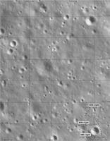
Yutu-2 route map |

  |
Yutu-2 route map |
 Jan 14 2022, 11:51 PM Jan 14 2022, 11:51 PM
Post
#91
|
||
 Member  Group: Members Posts: 349 Joined: 20-June 07 From: Slovenia Member No.: 2461 |
My version in addition to Phil's. |
|
 |
 
|
|
|
Jan 16 2022, 08:38 AM
Post
#92
|
||
|
Solar System Cartographer Group: Members Posts: 10153 Joined: 5-April 05 From: Canada Member No.: 227 |
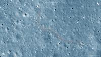
A very small map shown on sohu.com ( https://www.sohu.com/a/516861625_121218495 ) suggests the path during day 38. It is roughly sketched here, and I will update this when we get better data.
EDIT: Better map in a video on this site: http://www.hljtv.com/news/folder9/2022-01-16/848897.shtml I removed the earlier map and replaced it with a better one. Phil
-------------------- ... because the Solar System ain't gonna map itself.
Also to be found posting similar content on https://mastodon.social/@PhilStooke Maps for download (free PD: https://upload.wikimedia.org/wikipedia/comm...Cartography.pdf NOTE: everything created by me which I post on UMSF is considered to be in the public domain (NOT CC, public domain) |
|
|
|
|
|
|
Feb 4 2022, 03:38 AM
Post
#93
|
||
|
Solar System Cartographer Group: Members Posts: 10153 Joined: 5-April 05 From: Canada Member No.: 227 |
We are well into the 39th lunar day today so here is an updated full map.
Phil
-------------------- ... because the Solar System ain't gonna map itself.
Also to be found posting similar content on https://mastodon.social/@PhilStooke Maps for download (free PD: https://upload.wikimedia.org/wikipedia/comm...Cartography.pdf NOTE: everything created by me which I post on UMSF is considered to be in the public domain (NOT CC, public domain) |
|
|
|
|
|
|
Feb 27 2022, 12:06 AM
Post
#94
|
||
|
Solar System Cartographer Group: Members Posts: 10153 Joined: 5-April 05 From: Canada Member No.: 227 |
Using images from the drive diary I have estimated the route for the 39th day. This could be wrong! But it's the best I can do at this stage.
Phil
-------------------- ... because the Solar System ain't gonna map itself.
Also to be found posting similar content on https://mastodon.social/@PhilStooke Maps for download (free PD: https://upload.wikimedia.org/wikipedia/comm...Cartography.pdf NOTE: everything created by me which I post on UMSF is considered to be in the public domain (NOT CC, public domain) |
|
|
|
|
|
|
Feb 27 2022, 12:53 AM
Post
#95
|
||
|
Solar System Cartographer Group: Members Posts: 10153 Joined: 5-April 05 From: Canada Member No.: 227 |
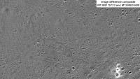
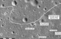
Good news on the map front. The LROC team have updated their featured sites page to include Chang'e 4 and Yutu 2. You can explore their images of the site here"
https://www.lroc.asu.edu/featured_sites/view_site/64 By taking the first (pre-landing) image and one near the end of the period covered with almost identical lighting, it is possible to make a difference image which shows the tracks. The later image was taken during day 35. Phil
-------------------- ... because the Solar System ain't gonna map itself.
Also to be found posting similar content on https://mastodon.social/@PhilStooke Maps for download (free PD: https://upload.wikimedia.org/wikipedia/comm...Cartography.pdf NOTE: everything created by me which I post on UMSF is considered to be in the public domain (NOT CC, public domain) |
|
|
|
|
|
|
Apr 15 2022, 02:54 AM
Post
#96
|
||
|
Solar System Cartographer Group: Members Posts: 10153 Joined: 5-April 05 From: Canada Member No.: 227 |
The latest news discussed in the other thread leads to this updated map. The source is small and unclear so this might need an edit but it is a reasonable estimate at this time. My 40th night location should possibly be at the next stop.
Phil
-------------------- ... because the Solar System ain't gonna map itself.
Also to be found posting similar content on https://mastodon.social/@PhilStooke Maps for download (free PD: https://upload.wikimedia.org/wikipedia/comm...Cartography.pdf NOTE: everything created by me which I post on UMSF is considered to be in the public domain (NOT CC, public domain) |
|
|
|
|
|
|
Apr 15 2022, 03:00 AM
Post
#97
|
||
|
Solar System Cartographer Group: Members Posts: 10153 Joined: 5-April 05 From: Canada Member No.: 227 |
And the full map to go with it.
Phil
-------------------- ... because the Solar System ain't gonna map itself.
Also to be found posting similar content on https://mastodon.social/@PhilStooke Maps for download (free PD: https://upload.wikimedia.org/wikipedia/comm...Cartography.pdf NOTE: everything created by me which I post on UMSF is considered to be in the public domain (NOT CC, public domain) |
|
|
|
|
|
|
Apr 30 2022, 07:03 AM
Post
#98
|
||
|
Solar System Cartographer Group: Members Posts: 10153 Joined: 5-April 05 From: Canada Member No.: 227 |
Here is a corrected map for the end of lunar day 41. The last day of driving comes largely from a map in the latest drive diary and should be reasonably accurate (the Chinese map - good. My speculation about the last bit - probably OK). I am still not certain about the location of the day 40 stop.
The previous map was based on another chinese map, published quite small and not very clear, but it seems to me that it was not showing the end of day 41 location, it only mapped up to lunar noon on day 41. Speaking of which, as i post this it is noon in lunar day 42. Phil
-------------------- ... because the Solar System ain't gonna map itself.
Also to be found posting similar content on https://mastodon.social/@PhilStooke Maps for download (free PD: https://upload.wikimedia.org/wikipedia/comm...Cartography.pdf NOTE: everything created by me which I post on UMSF is considered to be in the public domain (NOT CC, public domain) |
|
|
|
|
|
|
Jun 17 2022, 07:46 PM
Post
#99
|
||
|
Solar System Cartographer Group: Members Posts: 10153 Joined: 5-April 05 From: Canada Member No.: 227 |
This map for the end of lunar day 42 is updated using he latest drive diary, linked to in the other thread.
Phil
-------------------- ... because the Solar System ain't gonna map itself.
Also to be found posting similar content on https://mastodon.social/@PhilStooke Maps for download (free PD: https://upload.wikimedia.org/wikipedia/comm...Cartography.pdf NOTE: everything created by me which I post on UMSF is considered to be in the public domain (NOT CC, public domain) |
|
|
|
|
|
|
Jun 17 2022, 07:58 PM
Post
#100
|
||
|
Solar System Cartographer Group: Members Posts: 10153 Joined: 5-April 05 From: Canada Member No.: 227 |
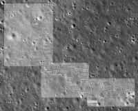
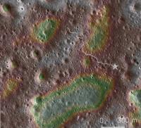
This context map shows the traverse as of day 42 and the broader context. The rover is nearly half way to the basalt region it hopes to reach, but its goals could be met quite well by finding ejecta blocks thrown out of craters in that area.
Phil
-------------------- ... because the Solar System ain't gonna map itself.
Also to be found posting similar content on https://mastodon.social/@PhilStooke Maps for download (free PD: https://upload.wikimedia.org/wikipedia/comm...Cartography.pdf NOTE: everything created by me which I post on UMSF is considered to be in the public domain (NOT CC, public domain) |
|
|
|
|
|
|
Jun 18 2022, 03:11 AM
Post
#101
|
||
|
Solar System Cartographer Group: Members Posts: 10153 Joined: 5-April 05 From: Canada Member No.: 227 |
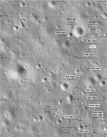
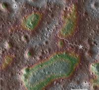
Another context map. A description of how it was made can be found earlier on this thread, but this is updated to lunar day 42.
Green areas are low, red and white areas are high. Phil
-------------------- ... because the Solar System ain't gonna map itself.
Also to be found posting similar content on https://mastodon.social/@PhilStooke Maps for download (free PD: https://upload.wikimedia.org/wikipedia/comm...Cartography.pdf NOTE: everything created by me which I post on UMSF is considered to be in the public domain (NOT CC, public domain) |
|
|
|
|
|
|
Jul 25 2022, 03:25 AM
Post
#102
|
||
|
Solar System Cartographer Group: Members Posts: 10153 Joined: 5-April 05 From: Canada Member No.: 227 |
Here is the full map up to day 44. It leaves me uncertain about day 43 but maybe we will get the details later.
Phil
-------------------- ... because the Solar System ain't gonna map itself.
Also to be found posting similar content on https://mastodon.social/@PhilStooke Maps for download (free PD: https://upload.wikimedia.org/wikipedia/comm...Cartography.pdf NOTE: everything created by me which I post on UMSF is considered to be in the public domain (NOT CC, public domain) |
|
|
|
|
|
|
Jan 3 2023, 10:06 PM
Post
#103
|
||
|
Solar System Cartographer Group: Members Posts: 10153 Joined: 5-April 05 From: Canada Member No.: 227 |
The first part of a map update to the end of lunar day 50. I have to work really hard not to say 'sol 50'.
The major goal at this stage is to reach the bright-rimmed crater at top left, which is on the edge of the basalt region. Anywhere between the current location and that crater a basalt ejecta block might be found, so suitable rocks are inspected carefully as they are encountered. It looks like it would take 3 more years to reach the crater. Either Queqiao must last that long or a replacement will be needed, and one is planned for (approximately) 2024 to support Chang'e 6 and this mission. As I understand it now, the sample return mission Chang'e 6 is aiming for the lava flows and crater ejecta inside Leibnitz crater, slightly north of Von Karman. Phil
-------------------- ... because the Solar System ain't gonna map itself.
Also to be found posting similar content on https://mastodon.social/@PhilStooke Maps for download (free PD: https://upload.wikimedia.org/wikipedia/comm...Cartography.pdf NOTE: everything created by me which I post on UMSF is considered to be in the public domain (NOT CC, public domain) |
|
|
|
|
|
|
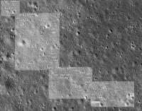
Jan 4 2023, 04:13 AM
Post
#104
|
|||
|
Solar System Cartographer Group: Members Posts: 10153 Joined: 5-April 05 From: Canada Member No.: 227 |
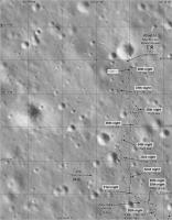
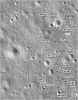
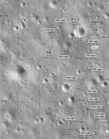
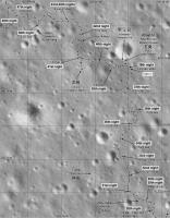
Here are two sections of my Yutu 2 route map at the standard scale I have been using since landing. Later I will make the overview showing the whole path. Some of the recent night locations are only guessed for now until I have more information.
Phil
-------------------- ... because the Solar System ain't gonna map itself.
Also to be found posting similar content on https://mastodon.social/@PhilStooke Maps for download (free PD: https://upload.wikimedia.org/wikipedia/comm...Cartography.pdf NOTE: everything created by me which I post on UMSF is considered to be in the public domain (NOT CC, public domain) |
||
|
|
|
||
|
Jan 4 2023, 05:01 AM
Post
#105
|
||
|
Solar System Cartographer Group: Members Posts: 10153 Joined: 5-April 05 From: Canada Member No.: 227 |
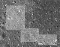
And my update of the full map... which needs an extension now.
Phil
-------------------- ... because the Solar System ain't gonna map itself.
Also to be found posting similar content on https://mastodon.social/@PhilStooke Maps for download (free PD: https://upload.wikimedia.org/wikipedia/comm...Cartography.pdf NOTE: everything created by me which I post on UMSF is considered to be in the public domain (NOT CC, public domain) |
|
|
|
|
|
|

|
Lo-Fi Version | Time is now: 28th April 2024 - 09:35 PM |
|
RULES AND GUIDELINES Please read the Forum Rules and Guidelines before posting. IMAGE COPYRIGHT |
OPINIONS AND MODERATION Opinions expressed on UnmannedSpaceflight.com are those of the individual posters and do not necessarily reflect the opinions of UnmannedSpaceflight.com or The Planetary Society. The all-volunteer UnmannedSpaceflight.com moderation team is wholly independent of The Planetary Society. The Planetary Society has no influence over decisions made by the UnmannedSpaceflight.com moderators. |
SUPPORT THE FORUM Unmannedspaceflight.com is funded by the Planetary Society. Please consider supporting our work and many other projects by donating to the Society or becoming a member. |
|