MSL Route Map |

  |
MSL Route Map |
 Aug 22 2017, 09:42 PM Aug 22 2017, 09:42 PM
Post
#1051
|
||
|
Solar System Cartographer  Group: Members Posts: 10151 Joined: 5-April 05 From: Canada Member No.: 227 |
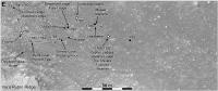
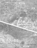
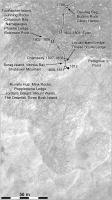
Sol 1793, a drive of about 22 m eastwards, well defined by the Hazcam images.
Phil
-------------------- ... because the Solar System ain't gonna map itself.
Also to be found posting similar content on https://mastodon.social/@PhilStooke Maps for download (free PD: https://upload.wikimedia.org/wikipedia/comm...Cartography.pdf NOTE: everything created by me which I post on UMSF is considered to be in the public domain (NOT CC, public domain) |
|
 |
 
|
|
|
Aug 23 2017, 01:57 PM
Post
#1052
|
|
 Member Group: Members Posts: 888 Joined: 15-June 09 From: Lisbon, Portugal Member No.: 4824 |
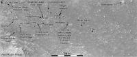
Update to sol 1794. I think Curiosity is close to turn south and take the final climb of VRR. Perhaps next week?
Fernando  The_Martian_Way_MSL_Curiosity_Sol_1794_2017AUG23.kmz ( 594.95K )
Number of downloads: 312
The_Martian_Way_MSL_Curiosity_Sol_1794_2017AUG23.kmz ( 594.95K )
Number of downloads: 312 |
|
|
|
|
Aug 23 2017, 04:16 PM
Post
#1053
|
||
|
Solar System Cartographer Group: Members Posts: 10151 Joined: 5-April 05 From: Canada Member No.: 227 |
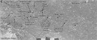
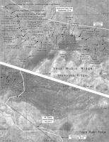
We had another drive on sol 1794, and I think this location should be accurate based on hazcams at the moment.
Phil
-------------------- ... because the Solar System ain't gonna map itself.
Also to be found posting similar content on https://mastodon.social/@PhilStooke Maps for download (free PD: https://upload.wikimedia.org/wikipedia/comm...Cartography.pdf NOTE: everything created by me which I post on UMSF is considered to be in the public domain (NOT CC, public domain) |
|
|
|
|
|
|
Aug 24 2017, 05:08 PM
Post
#1054
|
||
|
Solar System Cartographer Group: Members Posts: 10151 Joined: 5-April 05 From: Canada Member No.: 227 |
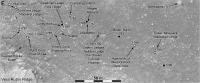
This is a preliminary update to sol 1795, based on a single Hazcam image. If it is seriously wrong I will replace the map later. EDIT: I did make a small change after the second Hazcam came in.
Phil
-------------------- ... because the Solar System ain't gonna map itself.
Also to be found posting similar content on https://mastodon.social/@PhilStooke Maps for download (free PD: https://upload.wikimedia.org/wikipedia/comm...Cartography.pdf NOTE: everything created by me which I post on UMSF is considered to be in the public domain (NOT CC, public domain) |
|
|
|
|
|
|
Aug 25 2017, 05:34 PM
Post
#1055
|
||
|
Solar System Cartographer Group: Members Posts: 10151 Joined: 5-April 05 From: Canada Member No.: 227 |
Sol 1796. I think I have the right place.
Phil
-------------------- ... because the Solar System ain't gonna map itself.
Also to be found posting similar content on https://mastodon.social/@PhilStooke Maps for download (free PD: https://upload.wikimedia.org/wikipedia/comm...Cartography.pdf NOTE: everything created by me which I post on UMSF is considered to be in the public domain (NOT CC, public domain) |
|
|
|
|
|
|
Aug 28 2017, 07:03 PM
Post
#1056
|
||
|
Solar System Cartographer Group: Members Posts: 10151 Joined: 5-April 05 From: Canada Member No.: 227 |
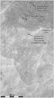
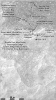
Zooming out for a wider view to place our location in context. For sol 1799, I am not very confident yet of the location.
Phil
-------------------- ... because the Solar System ain't gonna map itself.
Also to be found posting similar content on https://mastodon.social/@PhilStooke Maps for download (free PD: https://upload.wikimedia.org/wikipedia/comm...Cartography.pdf NOTE: everything created by me which I post on UMSF is considered to be in the public domain (NOT CC, public domain) |
|
|
|
|
|
|
Aug 30 2017, 02:41 AM
Post
#1057
|
||
|
Solar System Cartographer Group: Members Posts: 10151 Joined: 5-April 05 From: Canada Member No.: 227 |
Well, I was right to lack confidence in my last position. It is corrected here. But sol 1800 - that's right on target! Even the Hazcams give a good location. So near...
Phil
-------------------- ... because the Solar System ain't gonna map itself.
Also to be found posting similar content on https://mastodon.social/@PhilStooke Maps for download (free PD: https://upload.wikimedia.org/wikipedia/comm...Cartography.pdf NOTE: everything created by me which I post on UMSF is considered to be in the public domain (NOT CC, public domain) |
|
|
|
|
|
|
Sep 1 2017, 12:42 AM
Post
#1058
|
||
|
Solar System Cartographer Group: Members Posts: 10151 Joined: 5-April 05 From: Canada Member No.: 227 |
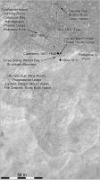
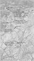
Another close-up map for the ascent. It looks to me like about a 10 to 12 m drive uphill on sol 1802. The names of features on the ridge will be relocated when I figure out where they are.
Phil
-------------------- ... because the Solar System ain't gonna map itself.
Also to be found posting similar content on https://mastodon.social/@PhilStooke Maps for download (free PD: https://upload.wikimedia.org/wikipedia/comm...Cartography.pdf NOTE: everything created by me which I post on UMSF is considered to be in the public domain (NOT CC, public domain) |
|
|
|
|
|
|
Sep 1 2017, 08:49 PM
Post
#1059
|
|
|
Member Group: Members Posts: 888 Joined: 15-June 09 From: Lisbon, Portugal Member No.: 4824 |
Update to 1802. Also corrected a bug in the Mars Clock (sol number display.)
Fernando
The_Martian_Way_MSL_Curiosity_Sol_1802_2017SEP01.kmz ( 597.77K )
Number of downloads: 264 |
|
|
|
|
Sep 6 2017, 03:24 AM
Post
#1060
|
||
|
Solar System Cartographer Group: Members Posts: 10151 Joined: 5-April 05 From: Canada Member No.: 227 |
Sol 1807, almost on the ridge.
Phil
-------------------- ... because the Solar System ain't gonna map itself.
Also to be found posting similar content on https://mastodon.social/@PhilStooke Maps for download (free PD: https://upload.wikimedia.org/wikipedia/comm...Cartography.pdf NOTE: everything created by me which I post on UMSF is considered to be in the public domain (NOT CC, public domain) |
|
|
|
|
|
|
Sep 8 2017, 04:57 PM
Post
#1061
|
|
|
Member Group: Members Posts: 888 Joined: 15-June 09 From: Lisbon, Portugal Member No.: 4824 |
Update to sol 1809. Seems there is still one last bit of climbing to do.
Fernando
The_Martian_Way_MSL_Curiosity_Sol_1809_2017SEP08.kmz ( 599.17K )
Number of downloads: 287 |
|
|
|
|
Sep 8 2017, 05:50 PM
Post
#1062
|
||
|
Solar System Cartographer Group: Members Posts: 10151 Joined: 5-April 05 From: Canada Member No.: 227 |
My sol 1809 map. Not at the highest point yet but well up on the ridge. If we go too much further south, even if higher, we will lose some of the view of the slope behind us. I really hope there will be a big Mastcam mosaic of the northward view while it is fully visible.
Phil
-------------------- ... because the Solar System ain't gonna map itself.
Also to be found posting similar content on https://mastodon.social/@PhilStooke Maps for download (free PD: https://upload.wikimedia.org/wikipedia/comm...Cartography.pdf NOTE: everything created by me which I post on UMSF is considered to be in the public domain (NOT CC, public domain) |
|
|
|
|
|
|
Sep 11 2017, 04:38 PM
Post
#1063
|
||
|
Solar System Cartographer Group: Members Posts: 10151 Joined: 5-April 05 From: Canada Member No.: 227 |
Sol 1812, a small move, probably to get to a good location for analysis before the next climb. This is estimated from Hazcams, where the rear view shows the motion clearly, but it might be an underestimate. As ever, it will be updated later.
Phil
-------------------- ... because the Solar System ain't gonna map itself.
Also to be found posting similar content on https://mastodon.social/@PhilStooke Maps for download (free PD: https://upload.wikimedia.org/wikipedia/comm...Cartography.pdf NOTE: everything created by me which I post on UMSF is considered to be in the public domain (NOT CC, public domain) |
|
|
|
|
|
|
Sep 14 2017, 06:26 AM
Post
#1064
|
||
|
Solar System Cartographer Group: Members Posts: 10151 Joined: 5-April 05 From: Canada Member No.: 227 |
A corrected and updated map for sol 1814. I'm making a new base for a map to fit in all the names.
Phil
-------------------- ... because the Solar System ain't gonna map itself.
Also to be found posting similar content on https://mastodon.social/@PhilStooke Maps for download (free PD: https://upload.wikimedia.org/wikipedia/comm...Cartography.pdf NOTE: everything created by me which I post on UMSF is considered to be in the public domain (NOT CC, public domain) |
|
|
|
|
|
|
Sep 14 2017, 07:18 PM
Post
#1065
|
||
|
Solar System Cartographer Group: Members Posts: 10151 Joined: 5-April 05 From: Canada Member No.: 227 |
Extra-zoomy map of our location on sol 1814. Don't get too hung up on the precision of the image rectification! It's controlled by a HiRISE image but not by a high resolution DEM.
Phil
-------------------- ... because the Solar System ain't gonna map itself.
Also to be found posting similar content on https://mastodon.social/@PhilStooke Maps for download (free PD: https://upload.wikimedia.org/wikipedia/comm...Cartography.pdf NOTE: everything created by me which I post on UMSF is considered to be in the public domain (NOT CC, public domain) |
|
|
|
|
|
|

|
Lo-Fi Version | Time is now: 26th April 2024 - 01:51 PM |
|
RULES AND GUIDELINES Please read the Forum Rules and Guidelines before posting. IMAGE COPYRIGHT |
OPINIONS AND MODERATION Opinions expressed on UnmannedSpaceflight.com are those of the individual posters and do not necessarily reflect the opinions of UnmannedSpaceflight.com or The Planetary Society. The all-volunteer UnmannedSpaceflight.com moderation team is wholly independent of The Planetary Society. The Planetary Society has no influence over decisions made by the UnmannedSpaceflight.com moderators. |
SUPPORT THE FORUM Unmannedspaceflight.com is funded by the Planetary Society. Please consider supporting our work and many other projects by donating to the Society or becoming a member. |
|