Endeavour Crater, And again shall we conquer the Remoteness |

  |
Endeavour Crater, And again shall we conquer the Remoteness |
 Sep 29 2008, 11:14 PM Sep 29 2008, 11:14 PM
Post
#16
|
||
 Senior Member  Group: Admin Posts: 3108 Joined: 21-December 05 From: Canberra, Australia Member No.: 615 |
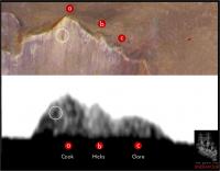
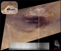
Not sure if this alternate view of Endeavour crater at 8 times vertical exaggeration will assist in this 'endeavour' (pun intended)

Astro0 |
|
 |
 
|
|
|
Sep 30 2008, 12:34 AM
Post
#17
|
|
|
Solar System Cartographer Group: Members Posts: 10146 Joined: 5-April 05 From: Canada Member No.: 227 |
That's really nice. You can see how the Meridiani Planum material drapes over the crater's northern rim and fills much of the depression. Those hills on the rim are part of the cratered terrain unit underlying the Meridiani Planum material. It would be a real coup to get to one of the rim hills.
Phil -------------------- ... because the Solar System ain't gonna map itself.
Also to be found posting similar content on https://mastodon.social/@PhilStooke NOTE: everything created by me which I post on UMSF is considered to be in the public domain (NOT CC, public domain) |
|
|
|
|
Sep 30 2008, 06:38 AM
Post
#18
|
||
 Special Cookie Group: Members Posts: 2168 Joined: 6-April 05 From: Sintra | Portugal Member No.: 228 |
Really, really nice!
Looking at this old image (if only I could remember which was the original I have used and how many times I stretched it...) it looks like that we can identify the contour of Cook and the two following elevations to the south. I won't dare to say that I can see the crater in Cook's slope, that is probably an artifact...  I'll look at this with more attention after having a bath and a coffee... And James...I don't think that climber was being that technical when he made reference to my "Cook"...  EDITED: Had a bath, had a coffee, had the work done... Here's what I was talking about:
Probably wrong (from James image looks like the three elevations fit all in Cook) but the contour seems to coincide... You'll also notest that I've named the three features with names previously used in this thread first post (already edited) but I think that it would make more sense to have the three lieutenants together at the "vessel's bridge". In consequence I had to pick new names for the peaks in the NW, I've took the option of going for the civilians onboard Endeavour, maybe we can follow this line of thought from here on: NW to NE - The Civilians SW to SE - The Marines E - The Crew Full list here. James...are we getting somewhere?
-------------------- "Ride, boldly ride," The shade replied, "If you seek for Eldorado!"
Edgar Alan Poe |
|
|
|
|
|
|
Sep 30 2008, 08:56 AM
Post
#19
|
|
 Senior Member Group: Members Posts: 1619 Joined: 12-February 06 From: Bergerac - FR Member No.: 678 |
Astro0 : I'm curious to know how do you obtain a such precise elevation of Endeavour? I really enjoy to make simulation in Terragen
.
-------------------- |
|
|
|
|
Sep 30 2008, 09:12 AM
Post
#20
|
|
|
Founder Group: Chairman Posts: 14431 Joined: 8-February 04 Member No.: 1 |
It's from the HRSCView website - from MEX HRSC data. Honestly, the data really isn't that good.
DOug |
|
|
|
|
Sep 30 2008, 10:31 AM
Post
#21
|
||
 Senior Member Group: Moderator Posts: 2262 Joined: 9-February 04 From: Melbourne - Oz Member No.: 16 |
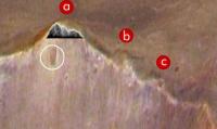
QUOTE (ustrax @ Sep 30 2008, 07:38 AM)  James...are we getting somewhere? This is a guess, I'm at work and don't have the time or the tools to do a proper analysis so the scale could be well off. But I would say it should be more like this...
Attached thumbnail(s)
-------------------- |
|
|
|
|
|
|
Sep 30 2008, 10:45 AM
Post
#22
|
|
|
Senior Member Group: Members Posts: 2918 Joined: 14-February 06 From: Very close to the Pyrénées Mountains (France) Member No.: 682 |
For quite a while, we're going to extract as much informations of Endeavour's rim as possible from a few pixels.
I wonder if pictures (from Spirit) of the rim of Gusev can be used to better help assuming what is real and what it's not. I'm sure we can find, in the data base, pictures of Gusev's rim at approximately the same distance, such pictures from the plain could be compared to pictures from the top of Husband's hill. I'm here assessing that the quality from the top is better than from the plain. Later into the traverse we'll be able to compare some Victoria's features (at least the Beacon I guess) as seen from a distance to what we realy know. Just a thought. -------------------- |
|
|
|
|
Sep 30 2008, 10:49 AM
Post
#23
|
|
|
Senior Member Group: Members Posts: 2918 Joined: 14-February 06 From: Very close to the Pyrénées Mountains (France) Member No.: 682 |
QUOTE (jamescanvin @ Sep 30 2008, 12:31 PM) This is a guess, I'm at work and don't have the time or the tools to do a proper analysis so the scale could be well off. But I would say it should be more like this... It's visualy my feeling too... The left ridge of the summit was not matching at all in Rui's proposition but it does here. -------------------- |
|
|
|
|
Sep 30 2008, 11:14 AM
Post
#24
|
||
|
Special Cookie Group: Members Posts: 2168 Joined: 6-April 05 From: Sintra | Portugal Member No.: 228 |
James is my hero!...
 A perfect match! Guess I'll have to restrain myself before posting this ideas without checking the details carefully... Looks like we've nailed Cook without doubts!:
BTW, new navcams and pancams are in, nothing new in the horizon, at least for my eyes, guess the driving guys will be pleased... -------------------- "Ride, boldly ride," The shade replied, "If you seek for Eldorado!"
Edgar Alan Poe |
|
|
|
|
|
|
Sep 30 2008, 12:11 PM
Post
#25
|
|
|
Senior Member Group: Moderator Posts: 2262 Joined: 9-February 04 From: Melbourne - Oz Member No.: 16 |
QUOTE (ustrax @ Sep 30 2008, 12:14 PM) A perfect match! Guess I'll have to restrain myself before posting this ideas without checking the details carefully... Where would we be without your crazy ideas?  Keep 'em coming - with just a small dose reality we've ended up with your fantastic (and probably accurate ) last diagram.Onwards! J -------------------- |
|
|
|
|
Sep 30 2008, 12:24 PM
Post
#26
|
|
|
Senior Member Group: Admin Posts: 3108 Joined: 21-December 05 From: Canberra, Australia Member No.: 615 |
Ant103 - "I'm curious to know how do you obtain a such precise elevation of Endeavour?"
Doug - "It's from the HRSCView website - from MEX HRSC data." Yep Ant, Doug's right - it's from the HRSCView website. I don't claim to have any magical DEM data at my disposal. As I've said before, I'm about pretty pictures not the hard science. I hope too that we get some DEMs for Endeavour, as I'm sure that Doug and yourself will come up with some dazzling images and animations. Astro0 PS: Glad to see that image might have cleared up the "which peak is that on the horizon?" mystery.
|
|
|
|
|
Sep 30 2008, 12:45 PM
Post
#27
|
|
|
Founder Group: Chairman Posts: 14431 Joined: 8-February 04 Member No.: 1 |
I've tried using that HRSC DEM for animation - and it's...how can I put this politely.
Not very good. I'll leave it there. |
|
|
|
|
Sep 30 2008, 02:19 PM
Post
#28
|
||
|
Special Cookie Group: Members Posts: 2168 Joined: 6-April 05 From: Sintra | Portugal Member No.: 228 |
QUOTE (jamescanvin @ Sep 30 2008, 01:11 PM) Where would we be without your crazy ideas? I have no idea...Nicarágua? Here's the latest development of my work in progress:
I'll have one of this on the wall after I give it some retouches...
-------------------- "Ride, boldly ride," The shade replied, "If you seek for Eldorado!"
Edgar Alan Poe |
|
|
|
|
|
|
Sep 30 2008, 02:43 PM
Post
#29
|
|
|
Junior Member Group: Members Posts: 59 Joined: 25-December 05 From: Stevens Point, Wisconsin, USA Member No.: 619 |
Hypothetical question (and pardon if this is isnt the right thread for it) - Had we known for certain that Opportunity had 5 years and 25 km in her from the start and had we had HiRise pictures of all terrain within 25 km of the landing site, how might the exploration strategy have been different? Would less time have been spent at Victoria, and would she be approaching Endeavour right now? Or perhaps the rover team would have chosen to strike out in an entirely different direction from the landing site/Endurance?
|
|
|
|
|
Sep 30 2008, 03:06 PM
Post
#30
|
|
|
Founder Group: Chairman Posts: 14431 Joined: 8-February 04 Member No.: 1 |
QUOTE (rogelio @ Sep 30 2008, 03:43 PM) Hypothetical question You could get a million different answers for that. You could say that the purgatory style dunes in HiRISE imagery would have scared them off heading south, so they would have gone in another direction completely. You could say anything really. It wouldn't be any less or more right than any other answer. |
|
|
|
|

|
Lo-Fi Version | Time is now: 19th April 2024 - 06:41 PM |
|
RULES AND GUIDELINES Please read the Forum Rules and Guidelines before posting. IMAGE COPYRIGHT |
OPINIONS AND MODERATION Opinions expressed on UnmannedSpaceflight.com are those of the individual posters and do not necessarily reflect the opinions of UnmannedSpaceflight.com or The Planetary Society. The all-volunteer UnmannedSpaceflight.com moderation team is wholly independent of The Planetary Society. The Planetary Society has no influence over decisions made by the UnmannedSpaceflight.com moderators. |
SUPPORT THE FORUM Unmannedspaceflight.com is funded by the Planetary Society. Please consider supporting our work and many other projects by donating to the Society or becoming a member. |
|