T42 Flyby (March 25, 2008) |

  |
T42 Flyby (March 25, 2008) |
 Mar 20 2008, 10:39 PM Mar 20 2008, 10:39 PM
Post
#1
|
|
 Senior Member  Group: Moderator Posts: 2785 Joined: 10-November 06 From: Pasadena, CA Member No.: 1345 |
T42 Mission description now up.
http://saturn.jpl.nasa.gov/multimedia/prod...description.pdf Imaging highlights:
-Mike -------------------- Some higher resolution images available at my photostream: http://www.flickr.com/photos/31678681@N07/
|
 |
 
|
|
Mar 20 2008, 11:00 PM
Post
#2
|
|
 Senior Member Group: Moderator Posts: 3233 Joined: 11-February 04 From: Tucson, AZ Member No.: 23 |
Here is the Looking Ahead article: http://ciclops.org/view.php?id=4882
-------------------- &@^^!% Jim! I'm a geologist, not a physicist!
The Gish Bar Times - A Blog all about Jupiter's Moon Io |
|
|
|
|
Mar 26 2008, 06:00 PM
Post
#3
|
|
 Senior Member Group: Members Posts: 3648 Joined: 1-October 05 From: Croatia Member No.: 523 |
The Cassini-Huygens site just brought a smile to my face with this image:
 QUOTE With apologies to Douglas Adams, author of the classic science fiction novel "The Hitchhiker's Guide to the Galaxy": Earth is an utterly insignificant little blue-green planet far out in the uncharted backwaters of the unfashionable end of the western spiral arm of the galaxy. The sapient life forms on Earth are currently sending primitive technology to study the most spectacular planet in the Sun's system: Saturn. On this day, the primitive technology, will fly by Titan, the most Earth-like moon in that solar system. While Earth has been deemed "mostly harmless," the jury is still out on Titan. A little humor never hurt anyone.  On a side note, the Enceladus press conference on NASA TV (Media channel) is about to start. -------------------- |
|
|
|
|
Mar 27 2008, 10:34 AM
Post
#4
|
|
|
Rover Driver Group: Members Posts: 1015 Joined: 4-March 04 Member No.: 47 |
lovely layers (with detached haze the main one): http://saturn.jpl.nasa.gov/multimedia/imag...iImageID=146915
|
|
|
|
|
Mar 27 2008, 04:52 PM
Post
#5
|
|||
|
Senior Member Group: Moderator Posts: 2785 Joined: 10-November 06 From: Pasadena, CA Member No.: 1345 |
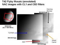
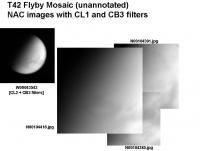
Mosaic of NAC images over Adiri, part of N Belet Cyclops, Sliced carrot of NW Shangri-La and the Dancing Monkey feature:
Boy, was this a challenge... Is there a new seasonal haze layer developing? Most of these features were barely discernible. It took awhile to identify Adiri and the Sliced Carrot. The Dancing Monkey feature is almost obscured. -Mike -------------------- Some higher resolution images available at my photostream: http://www.flickr.com/photos/31678681@N07/
|
||
|
|
|
||
|
Mar 27 2008, 06:21 PM
Post
#6
|
||
|
Senior Member Group: Moderator Posts: 2785 Joined: 10-November 06 From: Pasadena, CA Member No.: 1345 |
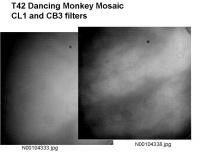
T42 Dancing Monkey mosaic. (I think this is how they go together.)
It is really hard to tell if I got this right...
-Mike -------------------- Some higher resolution images available at my photostream: http://www.flickr.com/photos/31678681@N07/
|
|
|
|
|
|
|
Mar 30 2008, 02:29 AM
Post
#7
|
|||
|
Senior Member Group: Moderator Posts: 2785 Joined: 10-November 06 From: Pasadena, CA Member No.: 1345 |
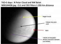
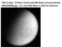
Nice! A long distance shot received yesterday has a view of the rarely imaged part of Titan around 300 W longitude.
http://saturn.jpl.nasa.gov/multimedia/imag...iImageID=147170
In this image you can see NW Belet and a very suspicious looking inky dark stain on the surface just to the N. And you can also see a few N polar clouds, too!! -Mike -------------------- Some higher resolution images available at my photostream: http://www.flickr.com/photos/31678681@N07/
|
||
|
|
|
||
|
Mar 30 2008, 02:53 PM
Post
#8
|
|
|
Newbie Group: Members Posts: 18 Joined: 1-July 05 Member No.: 425 |
idle hands...
http://i225.photobucket.com/albums/dd78/al...ushjobsmall.jpg (flyby42rushjobmedium.jpg for medium) various skews for interest |
|
|
|
|
Mar 30 2008, 03:44 PM
Post
#9
|
|
|
Senior Member Group: Moderator Posts: 2785 Joined: 10-November 06 From: Pasadena, CA Member No.: 1345 |
QUOTE (alexiton @ Mar 30 2008, 09:53 AM)  various skews for interest Nice enhancement of the clouds! Those clouds don't seem very circumpolar. They don't follow the terminator very well and seem pretty straight. It raises the possibility that the clouds may be orographically related. There are ridges up there that run roughly parallel and in the same orientation as the the cloud streaks. These ridges were observed in the T21 RADAR swath. -Mike -------------------- Some higher resolution images available at my photostream: http://www.flickr.com/photos/31678681@N07/
|
|
|
|
|
Mar 30 2008, 06:54 PM
Post
#10
|
|
|
Senior Member Group: Members Posts: 3516 Joined: 4-November 05 From: North Wales Member No.: 542 |
Is that the toe-of-Italy shaped arm of the big northern lake just appearing to the left of the cloud?
|
|
|
|
|
Mar 30 2008, 08:46 PM
Post
#11
|
|
|
Senior Member Group: Moderator Posts: 3233 Joined: 11-February 04 From: Tucson, AZ Member No.: 23 |
QUOTE Is that the toe-of-Italy shaped arm of the big northern lake just appearing to the left of the cloud? Yes QUOTE It raises the possibility that the clouds may be orographically related. There are ridges up there that run roughly parallel and in the same orientation as the the cloud streaks. These ridges were observed in the T21 RADAR swath. Those clouds are too far to the north and west. Besides, these clouds are more than likely similar to the mid-latitude clouds in the south, which are also not orogenic. -------------------- &@^^!% Jim! I'm a geologist, not a physicist!
The Gish Bar Times - A Blog all about Jupiter's Moon Io |
|
|
|
|
Mar 31 2008, 03:19 AM
Post
#12
|
|||||||
|
Senior Member Group: Moderator Posts: 2785 Joined: 10-November 06 From: Pasadena, CA Member No.: 1345 |
Curiosity got the better of me....
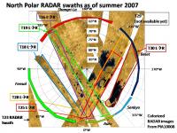
So where are these clouds anyway? And with all that RADAR coverage up north, can we figure what kind of terrain is beneath them?
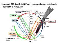
Here is a graphic showing the north polar RADAR swaths overlaid on a grid that shows the RADAR swath names and latitude and longitude. (At the very top right is just barely seen the T19 Swath).
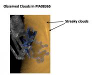
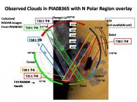
Similar clouds were observed in the same location in PIA08365 as in images taken during T42. PIA08364 shows a ISS and RADAR images with an outline of the big north polar lake. (According to the catalog page, the ISS image was taken on February 25, 2007). That might indicate a long-lived cloud at this location or this may just be great place to make clouds.
Here is a graphic with the north polar RADAR swaths overlaid on PIA08366. The T30 RADAR Swath should have imaged some of the terrain that underlies the clouds.
Here is a graphic with the T30 RADAR Swath and the outline of the cloud. The dark section of lake was used to make the correct line-up.
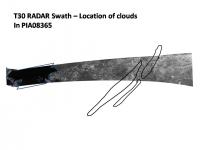
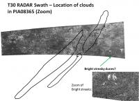
Here is a graphic of the T30 RADAR swath showing the location of the clouds. Also a zoom region. The terrain type is pretty non-descript, many blobby features, possibly some type of dried lakebed type terrain or it could be canyon or it could be plains as well. Who knows? There are some channel-like features barely discernable which seem to flow from left to right across the zoomed image. If there was any type of topographic rise parallel to the clouds, the channel-like features would need to cut through them. At the lower left in the zoomed image (zoomed further in the inset) there are bright streaks that may be aeolian deposits. There are no obvious tectonic ridges in this area. -Mike -------------------- Some higher resolution images available at my photostream: http://www.flickr.com/photos/31678681@N07/
|
||||||
|
|
|
||||||
|
Mar 31 2008, 09:25 AM
Post
#13
|
|
|
Senior Member Group: Members Posts: 3516 Joined: 4-November 05 From: North Wales Member No.: 542 |
The southern margins of the great lake could be an area where there is higher than average evaporation of methane from the surface, leading to cloud formation down-wind (???)
|
|
|
|
|
Apr 2 2008, 07:44 AM
Post
#14
|
|
|
Member Group: Members Posts: 699 Joined: 1-April 08 From: Minnesota ! Member No.: 4081 |
I believe the clouds coincide with the margin of the huge polar ethane/methane cloud beautifully imaged (PIA09171) by VIMS on 2/1/07. This polar cloud seems to be a persistent feature (although may change as Titan's north pole passes from winter to springtime) and was observed to reach to 62 degrees N latitude at all observed longitudes. Polar atmospheric weather/temperature conditions must be more important than surface topography in producing the clouds.
Speaking of topography, Planetary Photojournal has just put up a nice topographic map of a strip of the N polar region (PIA10353) covering that fascinating region with seas, islands and great rivers! |
|
|
|
|
Apr 2 2008, 05:30 PM
Post
#15
|
|
|
Senior Member Group: Moderator Posts: 2785 Joined: 10-November 06 From: Pasadena, CA Member No.: 1345 |
Welcome to UMSF, titanicrivers!
There were also clouds imaged in the southern hemisphere of Titan as well. An image of these can be found on the VIMS website: http://wwwvims.lpl.arizona.edu/whatsnew.html There is also a cool movie as well from the T17 flyby. A few frames show apparent movement of the cloud features. According to the captions the blue/white VIMS color in these images corresponds to liquid methane clouds at 10-30 km altitude. I would suspect that the clouds in the VIMS north polar image would be at the same altitude. (Anyone know?) 10-30 km altitude is pretty high up there. This is about the same level as polar stratospheric clouds (nacreous clouds) in Earth's atmosphere. From Wikipedia \Polar stratospheric cloud : "In the Northern hemisphere, the generation of lee waves by mountains may locally cool the lower stratosphere and lead to the formation of PSCs." So even clouds at that altitude could feel the effects of topography. I would add that a converging surface windfield on Titan possibly indicated by mid-latitude dune orientations might also cause enough of a "bump" in the atmosphere that it could trigger polar cloud formation. (See this post for possible evidence of converging surface winds in higher latitudes). {BTW, does anyone know the location of the thicker knot of clouds in the PIA09171 image? When I tried to guesstimate using the terminator and the mission description I came up with a rough guess of [65N, 100W]} -Mike -------------------- Some higher resolution images available at my photostream: http://www.flickr.com/photos/31678681@N07/
|
|
|
|
|

|
Lo-Fi Version | Time is now: 25th April 2024 - 09:14 AM |
|
RULES AND GUIDELINES Please read the Forum Rules and Guidelines before posting. IMAGE COPYRIGHT |
OPINIONS AND MODERATION Opinions expressed on UnmannedSpaceflight.com are those of the individual posters and do not necessarily reflect the opinions of UnmannedSpaceflight.com or The Planetary Society. The all-volunteer UnmannedSpaceflight.com moderation team is wholly independent of The Planetary Society. The Planetary Society has no influence over decisions made by the UnmannedSpaceflight.com moderators. |
SUPPORT THE FORUM Unmannedspaceflight.com is funded by the Planetary Society. Please consider supporting our work and many other projects by donating to the Society or becoming a member. |
|