Chang'e 3: Lunar Day 3 and onwards, Ongoing discussion of the Rover/Lander mission |

  |
Chang'e 3: Lunar Day 3 and onwards, Ongoing discussion of the Rover/Lander mission |
 Feb 19 2016, 08:44 PM Feb 19 2016, 08:44 PM
Post
#136
|
|
|
Solar System Cartographer  Group: Members Posts: 10151 Joined: 5-April 05 From: Canada Member No.: 227 |
Update on February 18th:
https://twitter.com/uhf_satcom ------------------------------------- UHF Satcom @uhf_satcom Nothing again tonite on X-Band from either the Yutu lunar rover or the Chang'e'3 lander - will check again tomorrow! ------------------------------------- The same (very useful) source detected nothing last month as well. Note that the negative result only applies to the specific times of monitoring, and there may have been activity when uhf_satcom was not facing (or listening to) the Moon but China was in contact. Phil -------------------- ... because the Solar System ain't gonna map itself.
Also to be found posting similar content on https://mastodon.social/@PhilStooke Maps for download (free PD: https://upload.wikimedia.org/wikipedia/comm...Cartography.pdf NOTE: everything created by me which I post on UMSF is considered to be in the public domain (NOT CC, public domain) |
 |
 
|
|
Feb 20 2016, 03:06 AM
Post
#137
|
|
|
Junior Member Group: Members Posts: 31 Joined: 10-January 14 Member No.: 7094 |
QUOTE (Phil Stooke @ Feb 20 2016, 04:44 AM)  Update on February 18th: https://twitter.com/uhf_satcom ------------------------------------- UHF Satcom @uhf_satcom Nothing again tonite on X-Band from either the Yutu lunar rover or the Chang'e'3 lander - will check again tomorrow! ------------------------------------- The same (very useful) source detected nothing last month as well. Note that the negative result only applies to the specific times of monitoring, and there may have been activity when uhf_satcom was not facing (or listening to) the Moon but China was in contact. Phil http://energy.chinanews.com/sh/2016/02-19/7765315.shtml "嫦娥三号"超期服役14个月 "嫦娥五号"转入正样研制 记者19日从中国国家国防科技工业局获悉,嫦娥三号着陆器于2月18日成功自主唤醒,进入第28个月昼,工作正常。 SASTIND told reporter, Chang'e-3 lander has been wake up on februrary 18, |
|
|
|
|
Feb 20 2016, 07:19 AM
Post
#138
|
|
|
Solar System Cartographer Group: Members Posts: 10151 Joined: 5-April 05 From: Canada Member No.: 227 |
Thanks! That is very useful.
If you check out the link in the post above, there is a new image of the lander from the rover. It seems to have been taken in March 2014 from Yutu in its final resting place, and this is the first time I have seen it. Phil -------------------- ... because the Solar System ain't gonna map itself.
Also to be found posting similar content on https://mastodon.social/@PhilStooke Maps for download (free PD: https://upload.wikimedia.org/wikipedia/comm...Cartography.pdf NOTE: everything created by me which I post on UMSF is considered to be in the public domain (NOT CC, public domain) |
|
|
|
|
Feb 25 2016, 01:52 PM
Post
#139
|
|
|
Junior Member Group: Members Posts: 31 Joined: 10-January 14 Member No.: 7094 |
UHF Satcom @uhf_satcom 2月22日
Another quick FFT of Yutu Rover X-Band downlink - nothing detected from Chang'e'3 lander or 7GHz uplinks. UHF Satcom @uhf_satcom 2月22日 Yutu Lunar Rover is back in town! A massive signal on 8462.053MHz complete with sidebands, maybe low-rate data. |
|
|
|
|
May 18 2016, 06:00 AM
Post
#140
|
|
|
Solar System Cartographer Group: Members Posts: 10151 Joined: 5-April 05 From: Canada Member No.: 227 |
UHF Satcom @uhf_satcom · 10 hours ago [ = the night of the 17th/18th of May ]
No signals from Chang'e'3 lander or Yutu Lunar Rover tonite - caught a glimpse of 8496MHz lander downlink last night but it was short lived. ---------------- Phil (PS: UHF Satcom is in the UK, so transmissions when Chang'E 3 and Yutu are visible in China but not in the UK will not be detected) -------------------- ... because the Solar System ain't gonna map itself.
Also to be found posting similar content on https://mastodon.social/@PhilStooke Maps for download (free PD: https://upload.wikimedia.org/wikipedia/comm...Cartography.pdf NOTE: everything created by me which I post on UMSF is considered to be in the public domain (NOT CC, public domain) |
|
|
|
|
Jun 20 2016, 07:05 PM
Post
#141
|
|
|
Solar System Cartographer Group: Members Posts: 10151 Joined: 5-April 05 From: Canada Member No.: 227 |
UHF Satcom reports no contact with Chang'E 3 or Yutu in June.
Phil -------------------- ... because the Solar System ain't gonna map itself.
Also to be found posting similar content on https://mastodon.social/@PhilStooke Maps for download (free PD: https://upload.wikimedia.org/wikipedia/comm...Cartography.pdf NOTE: everything created by me which I post on UMSF is considered to be in the public domain (NOT CC, public domain) |
|
|
|
|
Jul 29 2016, 08:03 AM
Post
#142
|
|
|
Junior Member Group: Members Posts: 31 Joined: 10-January 14 Member No.: 7094 |
http://www.sastind.gov.cn/n112/n117/c6636073/content.html
State Administration for Science, Technology and Industry for National Defense(SASTIND) reports latest news of Chang'e3 嫦娥三号着陆器于7月28日按时进入第33月夜休眠期 Chang'e-3 lander sleep on july 28 |
|
|
|
|
Sep 8 2016, 08:09 AM
Post
#143
|
|
 Member Group: Members Posts: 122 Joined: 3-September 12 From: Almeria, SE Spain Member No.: 6632 |
Great 360deg panoramas from Cháng'é-3 and Yùtù!
Put them full-screen, and you really think you're there! Thorsten |
|
|
|
|
Sep 8 2016, 09:29 PM
Post
#144
|
|
|
Senior Member Group: Members Posts: 1582 Joined: 14-October 05 From: Vermont Member No.: 530 |
An image of earth is just plopped in there? Or there was a massive hurricane over Texas?
|
|
|
|
|
Sep 8 2016, 09:37 PM
Post
#145
|
|
|
Member Group: Members Posts: 122 Joined: 3-September 12 From: Almeria, SE Spain Member No.: 6632 |
QUOTE (stevesliva @ Sep 8 2016, 11:29 PM) An image of earth is just plopped in there? Or there was a massive hurricane over Texas? Earth and Sun are faked obviously... |
|
|
|
|
Sep 28 2016, 10:40 PM
Post
#146
|
|
|
Solar System Cartographer Group: Members Posts: 10151 Joined: 5-April 05 From: Canada Member No.: 227 |
http://www.chinaspaceflight.com/satellite/.../CE-3/CE-3.html
According to this, Chang'E 3 has survived its 35th lunar day (September) and operated through the lunar eclipse on September 16, apparently using its telescope for astronomical observations during the eclipse. Phil -------------------- ... because the Solar System ain't gonna map itself.
Also to be found posting similar content on https://mastodon.social/@PhilStooke Maps for download (free PD: https://upload.wikimedia.org/wikipedia/comm...Cartography.pdf NOTE: everything created by me which I post on UMSF is considered to be in the public domain (NOT CC, public domain) |
|
|
|
|
May 6 2017, 03:33 PM
Post
#147
|
|
|
Solar System Cartographer Group: Members Posts: 10151 Joined: 5-April 05 From: Canada Member No.: 227 |
Today, May 6th, Chang'e 3 is expected to wake up for its 43rd lunar day. There is a schedule of day-night cycles here:
http://iloa.org/media/Chang'e3_Lunar_Day_Night_Cycle.pdf That is from the International Lunar Observatory Association which has a data-sharing agreement with China to use its UV telescope data. The list was issued in February so presumably the lander was active at that time. Phil -------------------- ... because the Solar System ain't gonna map itself.
Also to be found posting similar content on https://mastodon.social/@PhilStooke Maps for download (free PD: https://upload.wikimedia.org/wikipedia/comm...Cartography.pdf NOTE: everything created by me which I post on UMSF is considered to be in the public domain (NOT CC, public domain) |
|
|
|
|
Jun 13 2017, 03:42 AM
Post
#148
|
||
|
Solar System Cartographer Group: Members Posts: 10151 Joined: 5-April 05 From: Canada Member No.: 227 |
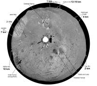
Looking back at the lander panoramas, this is a circular version of a panorama to show the distance to some horizon features. The western horizon was only a few hundred metres away, but several distant hills showed above it (see post on the page before this on the forum). The eastern horizon was between 2 and 4 km away with some crater rims visible, and to the north some distant topography showed above a nearby crater rim. The next image tries to identify the more distant features.
Phil
-------------------- ... because the Solar System ain't gonna map itself.
Also to be found posting similar content on https://mastodon.social/@PhilStooke Maps for download (free PD: https://upload.wikimedia.org/wikipedia/comm...Cartography.pdf NOTE: everything created by me which I post on UMSF is considered to be in the public domain (NOT CC, public domain) |
|
|
|
|
|
|
Jun 13 2017, 03:45 AM
Post
#149
|
||
|
Solar System Cartographer Group: Members Posts: 10151 Joined: 5-April 05 From: Canada Member No.: 227 |
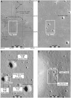
These maps zoom in to the lander location. In the first image some distant craters are indicated which appear to be the distant hills in the circular panorama. The northern hills might be crater rim or the ridge north of the crater.
Phil
-------------------- ... because the Solar System ain't gonna map itself.
Also to be found posting similar content on https://mastodon.social/@PhilStooke Maps for download (free PD: https://upload.wikimedia.org/wikipedia/comm...Cartography.pdf NOTE: everything created by me which I post on UMSF is considered to be in the public domain (NOT CC, public domain) |
|
|
|
|
|
|
Sep 8 2020, 08:24 PM
Post
#150
|
|
|
Solar System Cartographer Group: Members Posts: 10151 Joined: 5-April 05 From: Canada Member No.: 227 |
CE3's lander is still active! (as of June and July 2020 anyway):
https://twitter.com/df2mz/status/1282242945291374592 and https://twitter.com/uhf_satcom/status/1267556732080971776 There's also this article in Chinese: https://news.cctv.com/2020/09/02/ARTIqB5tNF...khi200902.shtml It refers to a recently published study using Yutu's radar data for subsurface structure and geological history. The original is here: https://agupubs.onlinelibrary.wiley.com/doi...29/2020GL088938 (it's not open access). But the Chinese article also mentions "As of September 1, 2020, Chang'e-3 has been in the moon for 2453 days, and it is now in a "retired" state, that is, in the long-term management stage, and part of the lander's scientific payload is still working." |(Google translation). That part of the payload might only be the communication system, for all this tells us, but it might also suggest the UV camera is still functioning. I have no confirmation of that, but I understand some papers from the UV data are in preparation. PS - for a recent paper on the UV data, see https://iopscience.iop.org/article/10.1088/...27/19/7/94/meta Phil -------------------- ... because the Solar System ain't gonna map itself.
Also to be found posting similar content on https://mastodon.social/@PhilStooke Maps for download (free PD: https://upload.wikimedia.org/wikipedia/comm...Cartography.pdf NOTE: everything created by me which I post on UMSF is considered to be in the public domain (NOT CC, public domain) |
|
|
|
|

|
Lo-Fi Version | Time is now: 25th April 2024 - 11:58 AM |
|
RULES AND GUIDELINES Please read the Forum Rules and Guidelines before posting. IMAGE COPYRIGHT |
OPINIONS AND MODERATION Opinions expressed on UnmannedSpaceflight.com are those of the individual posters and do not necessarily reflect the opinions of UnmannedSpaceflight.com or The Planetary Society. The all-volunteer UnmannedSpaceflight.com moderation team is wholly independent of The Planetary Society. The Planetary Society has no influence over decisions made by the UnmannedSpaceflight.com moderators. |
SUPPORT THE FORUM Unmannedspaceflight.com is funded by the Planetary Society. Please consider supporting our work and many other projects by donating to the Society or becoming a member. |
|