Exploring Mt Sharp north of the dunes - Part 2: Beyond Big Sky, Site 50-51, sol 1148-1171, October 29, 2015-November 23, 2015 |

  |
Exploring Mt Sharp north of the dunes - Part 2: Beyond Big Sky, Site 50-51, sol 1148-1171, October 29, 2015-November 23, 2015 |
 Oct 30 2015, 12:46 AM Oct 30 2015, 12:46 AM
Post
#1
|
||
|
Solar System Cartographer  Group: Members Posts: 10162 Joined: 5-April 05 From: Canada Member No.: 227 |
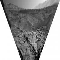
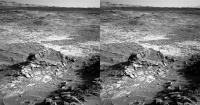
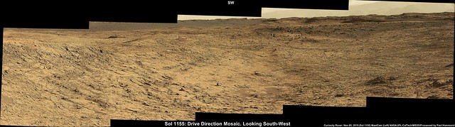
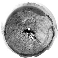
A drive on sol 1148 - looks like we are near the southern bend of Cut Bank Valley. This perspective view of a hazcam image is the only visual cue I have so far of its location. It looks along the west-running branch of the valley and its southern side.
Phil
-------------------- ... because the Solar System ain't gonna map itself.
Also to be found posting similar content on https://mastodon.social/@PhilStooke Maps for download (free PD: https://upload.wikimedia.org/wikipedia/comm...Cartography.pdf NOTE: everything created by me which I post on UMSF is considered to be in the public domain (NOT CC, public domain) |
|
 |
 
|
|
|
Oct 30 2015, 08:04 AM
Post
#2
|
|
 Senior Member Group: Members Posts: 2428 Joined: 30-January 13 From: Penang, Malaysia. Member No.: 6853 |
There will be a one-week suspension of MROs communication relay duty. Curiosity will use a different orbiter for relaying its data to Earth while MRO is out of service. Full details: Rewrite of Onboard Memory Planned for NASA Mars Orbiter
|
|
|
|
|
Oct 30 2015, 10:22 AM
Post
#3
|
||
|
Senior Member Group: Members Posts: 2830 Joined: 22-April 05 From: Ridderkerk, Netherlands Member No.: 353 |
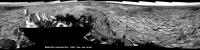
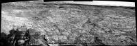
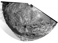
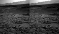
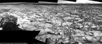
The Navcam L panoramic view on Sol 1148.
Jan van Driel
|
|
|
|
|
|
|
Oct 30 2015, 01:22 PM
Post
#4
|
||
|
Solar System Cartographer Group: Members Posts: 10162 Joined: 5-April 05 From: Canada Member No.: 227 |
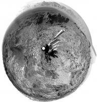
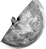
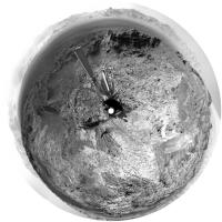
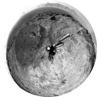
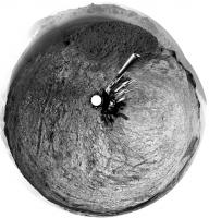
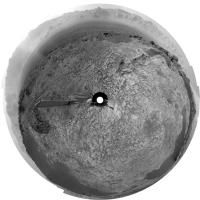
Great pan, thanks! Here is a circular reprojection of it - you can see how we are looking along the valley now. The path ahead looks a bit smoother.
Phil
-------------------- ... because the Solar System ain't gonna map itself.
Also to be found posting similar content on https://mastodon.social/@PhilStooke Maps for download (free PD: https://upload.wikimedia.org/wikipedia/comm...Cartography.pdf NOTE: everything created by me which I post on UMSF is considered to be in the public domain (NOT CC, public domain) |
|
|
|
|
|
|
Oct 30 2015, 04:18 PM
Post
#5
|
||
 Member Group: Members Posts: 902 Joined: 15-June 09 From: Lisbon, Portugal Member No.: 4824 |
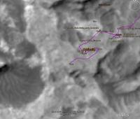
This is such a dificult terrain to be driving on (just see the 3D route map in Emily's blog) I can't resist adding a short map here.
Using Jan's excelent pan, Phil's reprojection, and after a lot of visual comparisons, here is where I think MSL is. A bit SSE of the location indicated by Phil. Fernando
|
|
|
|
|
|
|
Oct 30 2015, 08:33 PM
Post
#6
|
|
 Member Group: Members Posts: 244 Joined: 2-March 15 Member No.: 7408 |
|
|
|
|
|
Oct 31 2015, 01:30 AM
Post
#7
|
|
|
Senior Member Group: Members Posts: 2428 Joined: 30-January 13 From: Penang, Malaysia. Member No.: 6853 |
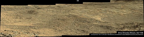
Mission Update from Ryan Anderson: Sols 1148-1152: Driving and Contact Science. LINK
QUOTE Apologies for the lack of an update on Wednesday this week! Lauren and I were both in a training class, and Ken was traveling so none of us were able to post here. That means that todays post covers five sols of planning!
The sol 1148 plan started off with a Mastcam observation of the target McLeod and a 10x1 mosaic to patch a gap in the mosaic from sol 1144. After that, we drove for 32 meters, followed by standard post-drive imaging. On Sol 1149, ChemCam did a bunch of calibration observations and Navcam and Mastcam did some standard atmospheric observations. The drive on Sol 1148 put us in range of some interesting rocks, and the Sol 1150-1152 plan is focusing on analyzing our new surroundings. On Sol 1150, Mastcam has an 8x4 mosaic of some interesting layered rocks, followed by ChemCam and Mastcam observations of the targets Dunkirk and Duperow. After the remote sensing is done, there are three APXS observations of the targets Exshaw, Ellis Canyon, and Ennis. On Sol 1151, Mastcam has an 18x2 mosaic of the Carlile area and a 9x2 mosaic of the East Glacier target. This is followed by ChemCam observations of Ennis and Exshaw and the accompanying Mastcam documentation images. In the afternoon on Sol 1151, there will be a short drive to the southeast which should provide data to allow a longer drive in the next plan. Finally, on Sol 1152, the plan is to do Navcam, Mastcam, and ChemCam atmospheric observations, plus some ChemCam focus tests. |
|
|
|
|
Oct 31 2015, 12:48 PM
Post
#8
|
|
|
Senior Member Group: Members Posts: 2428 Joined: 30-January 13 From: Penang, Malaysia. Member No.: 6853 |
|
|
|
|
|
Oct 31 2015, 07:04 PM
Post
#9
|
|
|
Member Group: Members Posts: 306 Joined: 4-October 14 Member No.: 7273 |
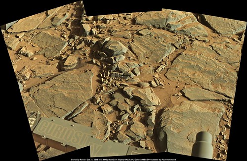
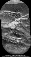
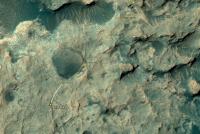
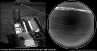
I stitched together the mosaic of McLeod from Sol 1148. One interesting feature in this outcrop are small white clasts. They almost look like rounded versions of the feldspar lathes that Curiosity has seen in other rocks.
 I had to downsize my version to keep it at a manageable size (the original stitch was something like 60mb), so a lot of smaller detail got lost. Here's a link to one of the full-res subframes that illustrates those "pebbles" nicely. And a couple of NavCam postcards. Been a while since I've found a good set of NavCam images that I thought would make good postcards. Sol 1144 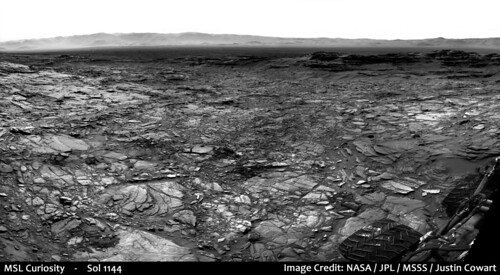 Sol 1148 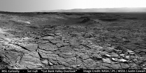
|
|
|
|
|
Nov 1 2015, 08:42 AM
Post
#10
|
|
|
Senior Member Group: Members Posts: 2428 Joined: 30-January 13 From: Penang, Malaysia. Member No.: 6853 |
|
|
|
|
|
Nov 1 2015, 09:40 PM
Post
#11
|
|
 Administrator Group: Admin Posts: 5172 Joined: 4-August 05 From: Pasadena, CA, USA, Earth Member No.: 454 |
QUOTE (jccwrt @ Oct 31 2015, 11:04 AM)  I stitched together the mosaic of McLeod from Sol 1148. One interesting feature in this outcrop are small white clasts. They almost look like rounded versions of the feldspar lathes that Curiosity has seen in other rocks. Those white things are interesting. They're just at the limit of what you can see in the JPEG compression so I'm not sure about a "rounded" shape (though I guess at least I agree with you that they're not lath-shaped, more equant). They are very white! Well spotted.-------------------- My website - My Patreon - @elakdawalla on Twitter - Please support unmannedspaceflight.com by donating here.
|
|
|
|
|
Nov 1 2015, 11:06 PM
Post
#12
|
||
|
Member Group: Members Posts: 306 Joined: 4-October 14 Member No.: 7273 |
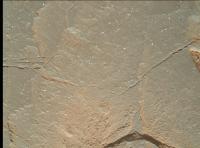
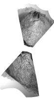
I think this MAHLI shot from Sol 1150 was taken of the same unit, although not in the same location. Some of those clasts even look like they've got an oolitc texture!
|
|
|
|
|
|
|
Nov 1 2015, 11:09 PM
Post
#13
|
|
|
Administrator Group: Admin Posts: 5172 Joined: 4-August 05 From: Pasadena, CA, USA, Earth Member No.: 454 |
Some of them seem to have darker colored centers?
-------------------- My website - My Patreon - @elakdawalla on Twitter - Please support unmannedspaceflight.com by donating here.
|
|
|
|
|
Nov 1 2015, 11:28 PM
Post
#14
|
|
|
Member Group: Members Posts: 306 Joined: 4-October 14 Member No.: 7273 |
Yeah. At first glance they look a lot like ooids to me (and you probably know this Emily, but for the non-geologists out there) it's where a clast rolls around on the seafloor or lakebed and collects a nice smooth mineral coating, sort of like a jawbreaker. On Earth that mineral is almost always calcium carbonate, which seems a bit weird for Gale Crater and is making me feel like I'm shooting from the hip with this interpretation.
Oolitic limestones are pretty common where I live, so I'm inclined to see them everywhere.  Most of the time they're packed together, but sometimes in lime mudstones (which these obviously aren't) you'll occasionally see a stray ooid or two. In this case I think reworking would be more likely for them to end up in this kind of rock. So if they are ooids, that kind of begs the question about the environment they formed in. Most of the time they're packed together, but sometimes in lime mudstones (which these obviously aren't) you'll occasionally see a stray ooid or two. In this case I think reworking would be more likely for them to end up in this kind of rock. So if they are ooids, that kind of begs the question about the environment they formed in.
|
|
|
|
|
Nov 2 2015, 05:20 AM
Post
#15
|
|||
 Senior Member Group: Members Posts: 4247 Joined: 17-January 05 Member No.: 152 |
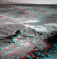
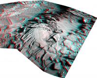
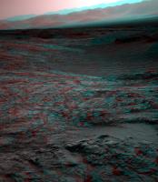
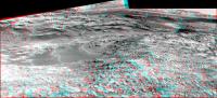
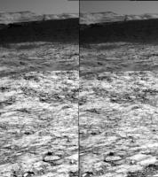
Lovely view on 1151. Anaglyph:
And cross-eyed:
|
||
|
|
|
||
|
Nov 2 2015, 07:35 PM
Post
#16
|
|
 Senior Member Group: Members Posts: 3419 Joined: 9-February 04 From: Minneapolis, MN, USA Member No.: 15 |
QUOTE (elakdawalla @ Nov 1 2015, 03:40 PM) Those white things are interesting. They're just at the limit of what you can see in the JPEG compression so I'm not sure about a "rounded" shape (though I guess at least I agree with you that they're not lath-shaped, more equant). They are very white! Well spotted. In the sub-frame, the white "clasts" look almost sparkly -- like a granite. Are we seeing any granitic signatures from this bed, I wonder? -the other Doug -------------------- The trouble ain't that there is too many fools, but that the lightning ain't distributed right. -Mark Twain
|
|
|
|
|
Nov 2 2015, 10:53 PM
Post
#17
|
|
|
Member Group: Members Posts: 306 Joined: 4-October 14 Member No.: 7273 |
The sparkliness of granite mostly comes from light catching flat surfaces on mineral grains. Here the sparkle effect seems to be just because the white clasts are so much brighter than the surrounding rock. Other than these clasts, McLeod looks almost identical to other Washboard rocks that Curiosity has been seeing over the last few months.
I'm almost certain that the MAHLI frame I posted is shows these white clasts in more detail. They're more or less round, which is a characteristic of sediment grains. If they were directly from a coarse-grained igneous rock (on Mars we're more likely to see the basaltic equivalent of granite -- gabbro), the clasts would have a more angular shape. But without more chemical information, I think you'd have a hard time distinguishing them between say, a feldspar grain eroded from gabbro and rounded off by sedimentary transport and a directly-precipitated sedimentary clast like an ooid. |
|
|
|
|
Nov 3 2015, 08:51 AM
Post
#18
|
|
|
Senior Member Group: Members Posts: 2428 Joined: 30-January 13 From: Penang, Malaysia. Member No.: 6853 |
Mission Update from Ryan Anderson: Sol 1153-1154: Driving Around LINK
QUOTE The short drive over the weekend went well, putting us in a good position for a longer drive in todays plan. Before we drive, ChemCam will analyze the targets Tampico, LaValle, and Muddy to determine if their apparent variations in brightness in the Navcam images correspond to a variation in chemistry. Mastcam will take documentation images of the ChemCam targets, plus a 13x3 mosaic of the resistant outcrop East Glacier and its surroundings. After the drive, which will take us past and around East Glacier and the dark material behind it, we will do our standard post-drive imaging. This week is a bit tricky because Mars Reconnaissance Orbiter (MRO) is in (intentional) Safe Mode for most of the week, meaning Curiosity cant send as much data back to Earth. So, its possible that the post-drive imaging that we usually use to target ChemCam wont come down in time to choose targets on Wednesday. If that happens, well have to make do with the Hazcam images. On Sol 1154, we are planning a ChemCam passive sky observation, plus Navcam movies to watch for clouds and dust devils. Mastcam will do a routine clast survey observation, plus a 27x2 mosaic to document the geology from our new location, and a MAHLI image of the ground underneath the rover.
|
|
|
|
|
Nov 3 2015, 02:17 PM
Post
#19
|
||
|
Senior Member Group: Members Posts: 2830 Joined: 22-April 05 From: Ridderkerk, Netherlands Member No.: 353 |
Looking in the drive direction.
Navcam L view on Sol 1151. Jan van Driel
|
|
|
|
|
|
|
Nov 3 2015, 02:46 PM
Post
#20
|
||
|
Solar System Cartographer Group: Members Posts: 10162 Joined: 5-April 05 From: Canada Member No.: 227 |
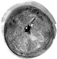
Nice view, thanks, Jan. Here is a rough reprojection of it, only approximately oriented north-up, to show the area in roughly map-like form. The valley with big drifts on the right is the area marked on my map as Meeteetse, not Cut Bank Valley. I still don't know for sure that I have the name in the right place for that.
Phil
-------------------- ... because the Solar System ain't gonna map itself.
Also to be found posting similar content on https://mastodon.social/@PhilStooke Maps for download (free PD: https://upload.wikimedia.org/wikipedia/comm...Cartography.pdf NOTE: everything created by me which I post on UMSF is considered to be in the public domain (NOT CC, public domain) |
|
|
|
|
|
|
Nov 3 2015, 05:55 PM
Post
#21
|
||
 Member Group: Members Posts: 334 Joined: 11-December 12 From: The home of Corby Crater (Corby-England) Member No.: 6783 |
From Sol1151, a bit too close to the edge for me !
Edit: Just looked at Jans' pan above, seems I might be a bit of a Wuss (http://www.thefreedictionary.com/wuss)_ |
|
|
|
|
|
|
Nov 4 2015, 08:34 AM
Post
#22
|
||
|
Senior Member Group: Members Posts: 2830 Joined: 22-April 05 From: Ridderkerk, Netherlands Member No.: 353 |
The Navcam L view on Sol 1153.
Jan van Driel
|
|
|
|
|
|
|
Nov 4 2015, 11:48 AM
Post
#23
|
||
|
Senior Member Group: Members Posts: 2428 Joined: 30-January 13 From: Penang, Malaysia. Member No.: 6853 |
Sol 1151: RMI-ChemCam target 'Ennis'? 4 overlapping frames roughly stitched using MS ICE. No additional processing
Flickr Original Size 1095 x 2024 pixels LINK Imgur mirror LINK Edit: Another take on the 1153 L-NavCam (full size with added compass points) 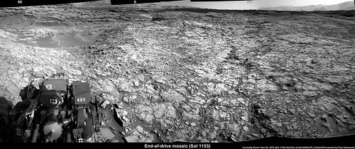 Flickr Original (3243 x 1361) LINK Imgur mirror LINK |
|
|
|
|
|
|
Nov 4 2015, 01:27 PM
Post
#24
|
||
|
Solar System Cartographer Group: Members Posts: 10162 Joined: 5-April 05 From: Canada Member No.: 227 |
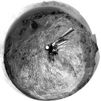
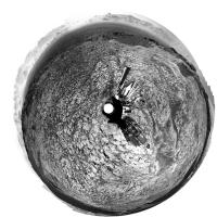
Nce views - here is Jan's image in circular form. (should be rotated a bit counter-clockwise)
Phil
-------------------- ... because the Solar System ain't gonna map itself.
Also to be found posting similar content on https://mastodon.social/@PhilStooke Maps for download (free PD: https://upload.wikimedia.org/wikipedia/comm...Cartography.pdf NOTE: everything created by me which I post on UMSF is considered to be in the public domain (NOT CC, public domain) |
|
|
|
|
|
|
Nov 4 2015, 03:14 PM
Post
#25
|
||
|
Solar System Cartographer Group: Members Posts: 10162 Joined: 5-April 05 From: Canada Member No.: 227 |
This is what the Hazcams show for location-finding purposes.
Phil
-------------------- ... because the Solar System ain't gonna map itself.
Also to be found posting similar content on https://mastodon.social/@PhilStooke Maps for download (free PD: https://upload.wikimedia.org/wikipedia/comm...Cartography.pdf NOTE: everything created by me which I post on UMSF is considered to be in the public domain (NOT CC, public domain) |
|
|
|
|
|
|
Nov 5 2015, 07:41 AM
Post
#26
|
|
|
Senior Member Group: Members Posts: 2428 Joined: 30-January 13 From: Penang, Malaysia. Member No.: 6853 |
Curiosity Mission Update from Ryan Anderson - Sol 1155-1156: Limited Downlink LINK
QUOTE Todays planning was a bit challenging because we only got a few Navcam images down to show us possible science targets, which limited our choices for ChemCam observations. We are all looking forward to Mars Reconnaissance Orbiter (MRO) waking up from the intentional safe mode status that it has been in this week! Still, even with limited data we were able to put together a good plan.
On Sol 1155, ChemCam will observe the targets Thermopolis and Pinckney to get measurements of the typical bedrock and typical soil or sand in the area, plus a long-distance image of one of the sand dunes that we are approaching. ChemCam will also do a focus test observation that was originally planned for last weekend, but which did not get uplinked because of a problem with the Deep Space Network. Mastcam will take documentation images of the two ChemCam targets and the distant sand dune, plus a 13x3 mosaic of a nearby outcrop. After that, the rover will drive and take standard post-drive images. On Sol 1156, we have a pretty light day. There are no geology observations, but several environmental and atmospheric measurements, including a couple Mastcam taus to measure the amount of dust in the atmosphere, some DAN observations, and a Navcam movie to look for clouds. MARDI also has a post-drive image of the ground under the rover... |
|
|
|
|
Nov 6 2015, 02:04 AM
Post
#27
|
|
|
Member Group: Members Posts: 866 Joined: 15-March 05 From: Santa Cruz, CA Member No.: 196 |
|
|
|
|
|
Nov 6 2015, 03:21 AM
Post
#28
|
|
|
Member Group: Members Posts: 148 Joined: 9-August 11 From: Mason, TX Member No.: 6108 |
QUOTE (atomoid @ Nov 5 2015, 08:04 PM) some stereo takes on sections of the sol1153 navcam The cross-eyed image seems to present a ring like a small exhumed crater just past the pit. Outstanding change of elevations here! -------------------- --
Don |
|
|
|
|
Nov 6 2015, 01:50 PM
Post
#29
|
||
|
Solar System Cartographer Group: Members Posts: 10162 Joined: 5-April 05 From: Canada Member No.: 227 |
A drive on sol 1155 - this reprojected Hazcam view suggests to me a drive of about 20 m to the west. (EDIT - no, nearly 40 m SW)
Phil
-------------------- ... because the Solar System ain't gonna map itself.
Also to be found posting similar content on https://mastodon.social/@PhilStooke Maps for download (free PD: https://upload.wikimedia.org/wikipedia/comm...Cartography.pdf NOTE: everything created by me which I post on UMSF is considered to be in the public domain (NOT CC, public domain) |
|
|
|
|
|
|
Nov 6 2015, 07:01 PM
Post
#30
|
|
|
Member Group: Members Posts: 244 Joined: 2-March 15 Member No.: 7408 |
Sols 1150 - 1155 travels
 135 right NAVCAM thumbnails |
|
|
|
|
Nov 7 2015, 08:11 AM
Post
#31
|
|
|
Senior Member Group: Members Posts: 2428 Joined: 30-January 13 From: Penang, Malaysia. Member No.: 6853 |
Mission Update from Ryan Anderson - Sol 1157-1159: A Busy Weekend on Mars: LINK
QUOTE Whew! Its going to be a busy weekend on Mars! The Sol 1157 plan starts off with an activity to test out AEGIS, a software tool that will help with choosing targets for ChemCam and Mastcam. The AEGIS activity will take ChemCam images of two targets: Ashley Lakes and Amsden. That is followed by a ChemCam observation of the target Augusta. Mastcam will take supporting images of Ashley Lakes and Amsden, plus an image of Dodd Ranch and two mosaics: a 3x2 and a 9x2. Once the remote sensing is done, the arm will get a workout. MAHLI and Mastcam have some images of the sky to help with calibration, and then MAHLI will take some images of its own calibration target and the APXS calibration target. After that, MAHLI will take some images of the wheels, and then APXS will measure its calibration target. Once that is finished, we will brush the dust off of the target Augusta, take some Mastcam and MAHLI images of it, and then place APXS on it to make some measurements on and off the brushed spot. On Sol 1158 the rover will drive to a location that looks to be a nice viewpoint, and that will be followed by standard post-drive images, including a 27x2 360 degree panorama with Mastcam. On Sol 1159, Mastcam has a tau observation to measure the amount of dust in the atmosphere, and Navcam has a couple of movies to watch for clouds and dust devils. Later in the day, Mastcam will do another tau, and ChemCam will make a measurement of its titanium calibration target. |
|
|
|
|
Nov 7 2015, 08:46 PM
Post
#32
|
||
|
Senior Member Group: Members Posts: 2830 Joined: 22-April 05 From: Ridderkerk, Netherlands Member No.: 353 |
The complete Navcam L panoramic view on Sol 1151.
Jan van Driel
|
|
|
|
|
|
|
Nov 7 2015, 09:57 PM
Post
#33
|
||
|
Senior Member Group: Members Posts: 2830 Joined: 22-April 05 From: Ridderkerk, Netherlands Member No.: 353 |
and the complete Navcam L view on Sol 1153-1154.
Jan van Driel
|
|
|
|
|
|
|
Nov 8 2015, 05:19 AM
Post
#34
|
|
|
Senior Member Group: Members Posts: 2428 Joined: 30-January 13 From: Penang, Malaysia. Member No.: 6853 |
|
|
|
|
|
Nov 8 2015, 12:52 PM
Post
#35
|
||
|
Senior Member Group: Members Posts: 2830 Joined: 22-April 05 From: Ridderkerk, Netherlands Member No.: 353 |
The Navcam L Panoramic view on Sol 1155.
Jan van Driel
|
|
|
|
|
|
|
Nov 8 2015, 03:31 PM
Post
#36
|
||||
|
Solar System Cartographer Group: Members Posts: 10162 Joined: 5-April 05 From: Canada Member No.: 227 |
Here are circular projections of Jan's latest three panoramas:
sol 1151:
sol 1153-54:
sol 1155:
Phil -------------------- ... because the Solar System ain't gonna map itself.
Also to be found posting similar content on https://mastodon.social/@PhilStooke Maps for download (free PD: https://upload.wikimedia.org/wikipedia/comm...Cartography.pdf NOTE: everything created by me which I post on UMSF is considered to be in the public domain (NOT CC, public domain) |
|||
|
|
|
|||
|
Nov 9 2015, 08:17 AM
Post
#37
|
|
|
Senior Member Group: Members Posts: 2428 Joined: 30-January 13 From: Penang, Malaysia. Member No.: 6853 |
|
|
|
|
|
Nov 9 2015, 09:35 AM
Post
#38
|
|
|
Senior Member Group: Members Posts: 2428 Joined: 30-January 13 From: Penang, Malaysia. Member No.: 6853 |
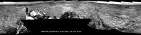
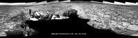
Sol 1158: Curiosity completes a 64 meter drive (Midnight Planets) Navcam Mosaic using the available images. Should be close to 'Brandberg', but we need the remaining NavCam's to check location. Roughly stitched in MS ICE
 Flickr Original Size 3695 x 1677 pixels LINK Imgur mirror TBA |
|
|
|
|
Nov 9 2015, 10:29 AM
Post
#39
|
||
|
Senior Member Group: Members Posts: 2428 Joined: 30-January 13 From: Penang, Malaysia. Member No.: 6853 |
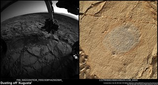
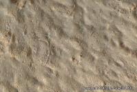
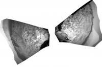
Some very interesting long/thin structures in this close-up MAHLI of Augusta. Anyone here got any suggestions as to what these structures could be? Image is unprocessed.
Link to raw http://mars.jpl.nasa.gov/msl-raw-images/ms...460R00_DXXX.jpg |
|
|
|
|
|
|
Nov 9 2015, 11:54 AM
Post
#40
|
|
|
Senior Member Group: Members Posts: 2920 Joined: 14-February 06 From: Very close to the Pyrénées Mountains (France) Member No.: 682 |
QUOTE (PaulH51 @ Nov 9 2015, 10:35 AM) Sol 1158: Curiosity completes a 64 meter drive (Midnight Planets) Navcam Mosaic using the available images. Should be close to 'Brandberg', but we need the remaining NavCam's to check location. Roughly stitched in MS ICE Imgur mirror TBA Do We have a meteorite (black rock) at 10h30 approx ? -------------------- |
|
|
|
| Guest_Actionman_* |
Nov 9 2015, 01:17 PM
Post
#41
|
|
|
Guests |
(1157 GIF) Looks like this is Augusta
Attached thumbnail(s)
|
|
|
|
|
|
|
Nov 9 2015, 02:11 PM
Post
#42
|
||
|
Solar System Cartographer Group: Members Posts: 10162 Joined: 5-April 05 From: Canada Member No.: 227 |
This is Paul's half panorama in circular form, showing where we are, adjacent to the rubble-covered Brandberg (right edge of his image).
Phil
-------------------- ... because the Solar System ain't gonna map itself.
Also to be found posting similar content on https://mastodon.social/@PhilStooke Maps for download (free PD: https://upload.wikimedia.org/wikipedia/comm...Cartography.pdf NOTE: everything created by me which I post on UMSF is considered to be in the public domain (NOT CC, public domain) |
|
|
|
|
|
|
Nov 9 2015, 10:15 PM
Post
#43
|
||
|
Senior Member Group: Members Posts: 2830 Joined: 22-April 05 From: Ridderkerk, Netherlands Member No.: 353 |
Here is the complete 360 degree Navcam L Panoramic view on Sol 1158.
Jan van Driel
|
|
|
|
|
|
|
Nov 10 2015, 01:57 AM
Post
#44
|
||
|
Solar System Cartographer Group: Members Posts: 10162 Joined: 5-April 05 From: Canada Member No.: 227 |
Thanks, Jan - and when it is reprojected you can see very clearly where we are relative to the rocky deposit (Brandberg).
Phil
-------------------- ... because the Solar System ain't gonna map itself.
Also to be found posting similar content on https://mastodon.social/@PhilStooke Maps for download (free PD: https://upload.wikimedia.org/wikipedia/comm...Cartography.pdf NOTE: everything created by me which I post on UMSF is considered to be in the public domain (NOT CC, public domain) |
|
|
|
|
|
|
Nov 10 2015, 07:27 AM
Post
#45
|
|
|
Senior Member Group: Members Posts: 2428 Joined: 30-January 13 From: Penang, Malaysia. Member No.: 6853 |
Mission Update: Sol 1160-1161: Brandberg by Ken Herkenhoff : LINK
QUOTE The 68-meter drive planned for Sol 1158 completed as planned, placing the rover near a dark, circular feature named "Brandberg." The tactical operations team studied the images of Brandberg and discussed the value of contact science observations in this area, ultimately deciding to drive on toward the Bagnold Dunes. But before leaving, ChemCam and Mastcam will observe targets "Hoba" and "Gibeon" on the Brandberg feature, which appears to be a remnant of a deposit that has been mostly eroded away. Observations of targets "Bogenfels"
and "Roter Kamm" are also planned, to better understand the rocks upon which the Brandberg material was deposited, as well as another test of the AEGIS software. Mastcam will also acquire mosaics of other interesting features before the Sol 1160 drive, including a sandy ripple named "Elim." The Sol 1161 plan is relatively simple, with the usual DAN, REMS, and RAD background observations along with a ChemCam measurement of the atmosphere over the rover. |
|
|
|
|
Nov 10 2015, 01:08 PM
Post
#46
|
||
|
Senior Member Group: Members Posts: 2346 Joined: 7-December 12 Member No.: 6780 |
QUOTE (PaulH51 @ Nov 9 2015, 12:29 PM) Some very interesting long/thin structures in this close-up MAHLI of Augusta. Anyone here got any suggestions as to what these structures could be? Scratches caused by the DRT. Here a crop of a 90° rotated version, to reduce optical illusion of raised features:
It's pointing towards the rock being soft. Maybe they've changed the method of brushing to avoid "micro-drillholes" and twisting of the bristles, meaning they may move the DRT during brushing. |
|
|
|
|
|
|
Nov 10 2015, 10:54 PM
Post
#47
|
|
|
Senior Member Group: Members Posts: 2428 Joined: 30-January 13 From: Penang, Malaysia. Member No.: 6853 |
QUOTE (Gerald @ Nov 10 2015, 09:08 PM) Scratches caused by the DRT. Here a crop of a 90° rotated version, to reduce optical illusion of raised features: It's pointing towards the rock being soft. Maybe they've changed the method of brushing to avoid "micro-drillholes" and twisting of the bristles, meaning they may move the DRT during brushing. Thanks Gerald, your rotated image allowed me to see they are grooves and not raised, which was my first impression. |
|
|
|
|
Nov 12 2015, 07:16 AM
Post
#48
|
|
|
Senior Member Group: Members Posts: 2428 Joined: 30-January 13 From: Penang, Malaysia. Member No.: 6853 |
Something unusual with the supply of engineering raw images for the drive on sol 1160? There are some images the were acquired before the drive started, and we even have a new JPL location map showing the path and post drive location,
 Not sure when we will be able to see those Buttes in the rovers images, but they sure will be a welcome sight... Not sure when we will be able to see those Buttes in the rovers images, but they sure will be a welcome sight... EDIT: JSON now reflects the status of all the available images. |
|
|
|
|
Nov 13 2015, 04:29 AM
Post
#49
|
|
|
Senior Member Group: Members Posts: 2428 Joined: 30-January 13 From: Penang, Malaysia. Member No.: 6853 |
Another Drive Planned : Mission Update: Sols 1162-1163: Approaching Bagnold Dunes by Ken Herkenhoff LINK
QUOTE Today is a holiday for some of us, but not the MSL tactical operations team! The 55-meter drive planned for Sol 1160 completed as planned, and another 41-meter drive is planned for Sol 1162. Before the next drive, Mastcam and ChemCam will observe a small, sandy drift named "Arris" and a bedrock target dubbed "Tsumeb." Mastcam will also acquire two mosaics, one of nearby outcrops and one of more distant rocks. The drive should place the rover between two of the Bagnold Dunes, so the vehicle will turn to a heading that will maximize the chances of acquiring good REMS measurements of wind speed and direction. This observation is part of the dune study campaign that has been developed over the past year, with an overall goal of better understanding how winds on Mars form and modify dunes. Observations of the dunes from orbit show that they are active, so many members of the MSL science team are looking forward to detailed measurements of the winds and their effects on the sand dunes and nearby terrain, as winds are currently the most significant agent of erosion on Mars. On Sol 1163, Mastcam will take pictures of the rover deck to allow tracking of changes in the distribution of dust and sand on the top of the vehicle, and image the sun to measure the amount of dust in the atmosphere. Navcam will also observe the sky and search for dust devils.
|
|
|
|
|
Nov 13 2015, 06:15 AM
Post
#50
|
|
|
Senior Member Group: Members Posts: 2428 Joined: 30-January 13 From: Penang, Malaysia. Member No.: 6853 |
|
|
|
|
|
Nov 13 2015, 01:14 PM
Post
#51
|
||
|
Senior Member Group: Members Posts: 2428 Joined: 30-January 13 From: Penang, Malaysia. Member No.: 6853 |
Joe Knapp's MSL drive page is showing the planned drive today (sol 1162) was completed, his location map needs adjusting, but we can use the path on his page to provide a rough estimate the new location after the drive which I have transposed onto JPL's sol 1160 location map. Posted here to reduce the signal to noise ratio on the MSL location thread. I'd rather have the engineering images, but once again we have another day without any...

|
|
|
|
|
|
|
Nov 14 2015, 03:14 AM
Post
#52
|
|
|
Senior Member Group: Members Posts: 2428 Joined: 30-January 13 From: Penang, Malaysia. Member No.: 6853 |
Mission Update from Ken Herkenhoff - Sols 1164-1165: Brushing "Swartkloofberg" LINK
QUOTE The rover drove over 38 meters on Sol 1162, as expected. We are transitioning out of restricted planning, so only 2 sols are being planned for this weekend. There were so many good ideas for activities this morning that the team had to decide which to remove from the plan to leave enough charge in the rover's batteries to enable nominal planning on Monday. Still, the plan is a very full one: On Sol 1164, ChemCam and Mastcam will observe one of the Bagnold Dunes that is a near-term goal for detailed investigation, plus other more nearby targets called "Swakop" and "Zaris." After another AEGIS checkout activity, the arm will be deployed to take a MAHLI image of the REMS UV sensor and of a rock dubbed "Swartkloofberg." Then the DRT will brush the dust off Swartkloofberg and MAHLI will acquire mosaics of the brushed spot and of Swakop before the APXS is placed on the brushed spot for an overnight integration. On Sol 1165, the arm will be stowed and the rover will drive farther south, again orienting the vehicle for REMS wind measurements. After sunset, SAM will clean its scrubbers, an engineering activity that has been performed twice before. Finally, the rover will go to sleep and recharge in preparation for the next sol's activities.
|
|
|
|
|
Nov 14 2015, 09:21 AM
Post
#53
|
|
|
Senior Member Group: Members Posts: 2428 Joined: 30-January 13 From: Penang, Malaysia. Member No.: 6853 |
|
|
|
|
|
Nov 14 2015, 10:15 AM
Post
#54
|
|
|
Senior Member Group: Members Posts: 2428 Joined: 30-January 13 From: Penang, Malaysia. Member No.: 6853 |
|
|
|
|
|
Nov 14 2015, 11:14 PM
Post
#55
|
|
|
Senior Member Group: Members Posts: 2428 Joined: 30-January 13 From: Penang, Malaysia. Member No.: 6853 |
Interesting jump / spike in the reported air pressure (Pa) from REMS
1161 = 1200 1160 = 1177 1159 = 898 1158 = 898 1157 = 900 1156 = 900 1155 = 900 1154 = 900 1153 = 900 1152 = 901 1151 = 901 We saw a single spike of 1150 Pa in Joe's REMS pressure chart that covered the first 740 sols... Probably just another spike, but will check the new data when its available
|
|
|
|
|
Nov 15 2015, 07:11 PM
Post
#56
|
|
|
Senior Member Group: Members Posts: 2346 Joined: 7-December 12 Member No.: 6780 |
The pressure jump doesn't look physical.
Calibrating and interpreting REMS data is far from trivial. Exposure to sun, or shadowing, a moving mast, warm-up, etc. may modify the raw data. For calibration, e.g. splines are used; switch from one polynomial to another may modify the interpretation. It's not quite clear, which effects have been considered for the implementation of the REMS website, and what's the default strategy in case of invalid data. Careful interpretation of the REMS PDS releases will eventually resolve the effect. |
|
|
|
|
Nov 16 2015, 01:38 AM
Post
#57
|
|
|
Senior Member Group: Members Posts: 2428 Joined: 30-January 13 From: Penang, Malaysia. Member No.: 6853 |
QUOTE (Gerald @ Nov 16 2015, 03:11 AM) The pressure jump doesn't look physical. I have to agree, it looked too high a jump to be 'real'. I only reported it here as it was elevated over two consecutive sols. And it will be many months before we have access to the PDS data. The REMS page has yet to update (after their usual weekend break), I will check later to see if the raw data trend continues, or if it returns back to the seasonal norms. |
|
|
|
|
Nov 16 2015, 08:07 AM
Post
#58
|
|
|
Senior Member Group: Members Posts: 2428 Joined: 30-January 13 From: Penang, Malaysia. Member No.: 6853 |
|
|
|
|
|
Nov 16 2015, 01:15 PM
Post
#59
|
|
|
Senior Member Group: Members Posts: 2428 Joined: 30-January 13 From: Penang, Malaysia. Member No.: 6853 |
Does anyone here know why the public release of Curiosity's engineering images as dried up?
As if that was not something to cause withdrawal symptoms, the sol 1151 mast cam images that have just been released are Bayer Encoded |
|
|
|
|
Nov 16 2015, 03:35 PM
Post
#60
|
|
|
Solar System Cartographer Group: Members Posts: 10162 Joined: 5-April 05 From: Canada Member No.: 227 |
Yes... I hope it will be fixed soon. At least we are not losing everything.
Phil -------------------- ... because the Solar System ain't gonna map itself.
Also to be found posting similar content on https://mastodon.social/@PhilStooke Maps for download (free PD: https://upload.wikimedia.org/wikipedia/comm...Cartography.pdf NOTE: everything created by me which I post on UMSF is considered to be in the public domain (NOT CC, public domain) |
|
|
|
|
Nov 16 2015, 07:33 PM
Post
#61
|
|||
|
Solar System Cartographer Group: Members Posts: 10162 Joined: 5-April 05 From: Canada Member No.: 227 |
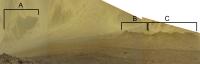
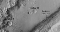
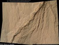
Meanwhile, here's a look at some distant features. We have started the climb up the lower slopes of the mountain, and the view to the north and west is improving. In this image I have made a mosaic of several Mastcam frames from sol 1144, with some contrast enhancement and a 6x vertical stretch:
A, B and C identify three crater rims, and this image locates them:
Phil -------------------- ... because the Solar System ain't gonna map itself.
Also to be found posting similar content on https://mastodon.social/@PhilStooke Maps for download (free PD: https://upload.wikimedia.org/wikipedia/comm...Cartography.pdf NOTE: everything created by me which I post on UMSF is considered to be in the public domain (NOT CC, public domain) |
||
|
|
|
||
|
Nov 17 2015, 02:59 AM
Post
#62
|
||
|
Senior Member Group: Members Posts: 2428 Joined: 30-January 13 From: Penang, Malaysia. Member No.: 6853 |
QUOTE (Phil Stooke @ Nov 16 2015, 11:35 PM) Yes... I hope it will be fixed soon.... We got a whole bunch of Engineering images today Thanks to JPL for fixing the issue....Too many errors likely caused by the heavy exposure variations, when I tried to stitch the end-of drive NavCam images together, probably better wait for Jan to perform his usual magic for those. Meanwhile here is a lightly cropped preview of the erosion resistant 'East Glacier', images acquired on sol 1153. Assembled using MS ICE into this 11x2 R-MastCam mosaic. I waited a while for the remaining frames, but looks like we may have a slightly longer wait for those. I can imagine a few of the geologists on this forum would like to have seen some contact science there, but I guess they have to take the keys off the scientists every now and again, else we would still be in Yellowknife Bay
Full size only loaded to Imgur 11811 x 2183 pixels LINK |
|
|
|
|
|
|
Nov 17 2015, 04:32 AM
Post
#63
|
|
|
Senior Member Group: Members Posts: 2428 Joined: 30-January 13 From: Penang, Malaysia. Member No.: 6853 |
Mission Update from Ryan Anderson - Sol 1165: Uplink Problems LINK
QUOTE Unfortunately, our plans for the weekend were thwarted by a problem with the Deep Space Network that prevented the plans from being sent to the rover. As someone on the team pointed out in response to the issue, this just goes to show how many steps in the process have to go just right for us to be able to operate a rover on Mars, and its pretty impressive that these sorts of issues are as rare as they are. Given its lack of instructions, Curiosity spent the weekend in runout mode. Runout mode mostly consists of environmental monitoring. Since the weekend plan was not uplinked, much of todays plan contains repeats of what we tried to do over the weekend. In the sol 1166 plan, ChemCam has observations of the targets Zaris and Swakop, and Mastcam has a 5x4 mosaic of Swakop and its surroundings. Then we have a block of arm activities to allow MAHLI to take some images of the targets Swartkloofberg and Swakop. This will be followed by brushing the dust off of Swartkloofberg, taking some more MAHLI images, and then placing APXS on Swartkloofberg to analyze it overnight. Meanwhile, this week is the ChemCam team meeting here at USGS in Flagstaff! Since much of the team will be busy with the meeting, ChemCam activities this week will be kept to just two or three per day. The meeting also means that Ken, Lauren, and I will be extra busy this week so we wont be blogging every day even though operations will be happening daily.
|
|
|
|
|
Nov 17 2015, 07:52 AM
Post
#64
|
|
|
Member Group: Members Posts: 306 Joined: 4-October 14 Member No.: 7273 |
A couple postcard views now that we've got a big NavCam dump.
 Curiosity - Sol 1160 by Justin Cowart, on Flickr  Curiosity - Sol 1162 by Justin Cowart, on Flickr Kind of working my way backwards through the NavCam images. Sol 1158 looks like it will make a great postcard since it's got a spectacular view of Cut Bank Valley. |
|
|
|
|
Nov 17 2015, 03:08 PM
Post
#65
|
|
|
Senior Member Group: Members Posts: 2428 Joined: 30-January 13 From: Penang, Malaysia. Member No.: 6853 |
|
|
|
|
|
Nov 17 2015, 09:10 PM
Post
#66
|
||
|
Senior Member Group: Members Posts: 2830 Joined: 22-April 05 From: Ridderkerk, Netherlands Member No.: 353 |
The Navcam L Panoramic view on Sol 1160.
Jan van Driel
|
|
|
|
|
|
|
Nov 18 2015, 12:37 AM
Post
#67
|
|
|
Member Group: Members Posts: 306 Joined: 4-October 14 Member No.: 7273 |
Curiosity took a 360 degree MastCam panorama on Sol 1154. I've stitched it together and done a little bit of warping to flatten the horizon out a bit. The mosaic just missed getting the top of Mt. Sharp, so I added three frames from the Sol 1144 MastCam mosaic to make sure the entire massif was in the panorama. The sky was pretty mangled from the compression artifacts, so I just removed it entirely and made a new one working off the original data.
 The full size version can be found here. (Warning: it's 69mb!) |
|
|
|
|
Nov 18 2015, 12:44 AM
Post
#68
|
|
|
Member Group: Members Posts: 866 Joined: 15-March 05 From: Santa Cruz, CA Member No.: 196 |
|
|
|
|
|
Nov 18 2015, 01:07 AM
Post
#69
|
||
|
Solar System Cartographer Group: Members Posts: 10162 Joined: 5-April 05 From: Canada Member No.: 227 |
Here is Jan's panorama from sol 1160 in circular form. A nice view of the outcrop.
Phil
-------------------- ... because the Solar System ain't gonna map itself.
Also to be found posting similar content on https://mastodon.social/@PhilStooke Maps for download (free PD: https://upload.wikimedia.org/wikipedia/comm...Cartography.pdf NOTE: everything created by me which I post on UMSF is considered to be in the public domain (NOT CC, public domain) |
|
|
|
|
|
|
Nov 18 2015, 10:37 AM
Post
#70
|
||
|
Senior Member Group: Members Posts: 2428 Joined: 30-January 13 From: Penang, Malaysia. Member No.: 6853 |
Midnight Planets is reporting : Curiosity moved approximately 34.1 meters (112 feet) south-south-west during Sol 1167 (November 18, 2015) Drive duration was ~55 minutes.
quickly assembled 'look ahead' mosaic using a selection of the available L-NavCams, assembled in MS ICE/ Clicking the image preview should open the file loaded on Imgur (Flickr was down)
|
|
|
|
|
|
|
Nov 18 2015, 10:41 AM
Post
#71
|
|
|
Senior Member Group: Members Posts: 2346 Joined: 7-December 12 Member No.: 6780 |
QUOTE (PaulH51 @ Nov 16 2015, 03:38 AM) The REMS page has yet to update (after their usual weekend break), I will check later to see if the raw data trend continues, or if it returns back to the seasonal norms. REMS mean pressure looks reasonable again with 897 Pa. |
|
|
|
|
Nov 18 2015, 12:57 PM
Post
#72
|
||
|
Senior Member Group: Members Posts: 2830 Joined: 22-April 05 From: Ridderkerk, Netherlands Member No.: 353 |
The Navcam L panorama on Sol 1162.
Jan van Driel
|
|
|
|
|
|
|
Nov 18 2015, 03:18 PM
Post
#73
|
|
|
Senior Member Group: Members Posts: 2428 Joined: 30-January 13 From: Penang, Malaysia. Member No.: 6853 |
QUOTE (Gerald @ Nov 18 2015, 06:41 PM) REMS mean pressure looks reasonable again with 897 Pa. Thanks Gerald, you beat me to it Meanwhile, staying on the topic of REMS, the UV detector was imaged on 1166 and we see an hefty increase in dust levels compared with the last image. Here is a montage showing the steady increase over 10 measurements.  Flickr Original Size 8320 x 2829 pixels LINK Imgur mirror LINK |
|
|
|
|
Nov 18 2015, 03:46 PM
Post
#74
|
||
|
Solar System Cartographer Group: Members Posts: 10162 Joined: 5-April 05 From: Canada Member No.: 227 |
Jan's 1162 panorama in circular format.
Phil
-------------------- ... because the Solar System ain't gonna map itself.
Also to be found posting similar content on https://mastodon.social/@PhilStooke Maps for download (free PD: https://upload.wikimedia.org/wikipedia/comm...Cartography.pdf NOTE: everything created by me which I post on UMSF is considered to be in the public domain (NOT CC, public domain) |
|
|
|
|
|
|
Nov 18 2015, 05:37 PM
Post
#75
|
|
|
Member Group: Members Posts: 244 Joined: 2-March 15 Member No.: 7408 |
NAVCAM travel animation for Sol 1160 is 47 frames.
Here's a small preview of the left NAVCAM's view.  And here is the full-size stereo pair animation for Parallel and Cross-Eye viewing. File sizes are 7 MiB each. NAVCAM travel animation for Sol 1162 is 51 frames. Here's a small preview of the left NAVCAM's view.  And here is the full-size stereo pair animation for Parallel and Cross-Eye viewing. File sizes are 8 MiB each. |
|
|
|
|
Nov 18 2015, 07:55 PM
Post
#76
|
|
|
Member Group: Members Posts: 306 Joined: 4-October 14 Member No.: 7273 |
Sol 1158 postcard, looking out over Brandenburg
 Curiosity - Sol 1158 by Justin Cowart, on Flickr Sol 1155 postcard, looking at Cut Bank Valley.  Sol 1155 Postcard by Justin Cowart, on Flickr |
|
|
|
|
Nov 19 2015, 10:13 AM
Post
#77
|
||
|
Senior Member Group: Members Posts: 2428 Joined: 30-January 13 From: Penang, Malaysia. Member No.: 6853 |
Before its drive on 1167, curiosity used its RMI to target Bagnald Dune #1, using the pointing data I think I may have located the target area on a 1162 NavCam frame.
Raw NavCam LINK Raw RMI LINK Another planned drive completed on Sol 1168 closer to the dunes, images still coming in.... Mission Update from Lauren Edgar - Sols 1167-1168: Onward to the Bagnold Dunes LINK QUOTE The Bagnold Dunes are tantalizingly close, and this week is mostly focused on driving to the dunes. On Sol 1167 Curiosity drove 39 m, and the dunes are starting to look pretty big, as seen in the above Navcam image. For more on our plans when we get to the dunes, check out this recent press release.
The plan today looks very similar to yesterday, with a pre-drive science block, a drive, and post-drive imaging. Science activities include Mastcam and ChemCam observations of the local bedrock at a target named Etosha, as well as Mastcam deck monitoring to look for fine sand that might accumulate as we approach the active dunes. After the drive well acquire standard imaging to prepare for future targeting and terrain assessment. Were also planning a SAM atmospheric observation to look for methane, exactly one Mars year after the previous high detections.... |
|
|
|
|
|
|
Nov 19 2015, 04:40 PM
Post
#78
|
||
|
Solar System Cartographer Group: Members Posts: 10162 Joined: 5-April 05 From: Canada Member No.: 227 |
Reprojecting the sol 1168 Hazcams helps to locate us:
Phil -------------------- ... because the Solar System ain't gonna map itself.
Also to be found posting similar content on https://mastodon.social/@PhilStooke Maps for download (free PD: https://upload.wikimedia.org/wikipedia/comm...Cartography.pdf NOTE: everything created by me which I post on UMSF is considered to be in the public domain (NOT CC, public domain) |
|
|
|
|
|
|
Nov 19 2015, 09:34 PM
Post
#79
|
|||
|
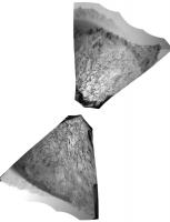
Member Group: Members Posts: 866 Joined: 15-March 05 From: Santa Cruz, CA Member No.: 196 |
a couple of stereograms (parellel) from sol1168 to try to get a sense of topography of Dune 1 leading edge at Curiosity left and the 'other dune trailing edge (on right)
|
||
|
|
|
||
|
Nov 20 2015, 06:47 AM
Post
#80
|
|
|
Senior Member Group: Members Posts: 2428 Joined: 30-January 13 From: Penang, Malaysia. Member No.: 6853 |
|
|
|
|
|
Nov 20 2015, 09:39 AM
Post
#81
|
||
|
Senior Member Group: Members Posts: 2830 Joined: 22-April 05 From: Ridderkerk, Netherlands Member No.: 353 |
The Navcam L panoramic view on Sol 1167.
Jan van Driel
|
|
|
|
|
|
|
Nov 20 2015, 09:55 AM
Post
#82
|
|
|
Senior Member Group: Members Posts: 2428 Joined: 30-January 13 From: Penang, Malaysia. Member No.: 6853 |
|
|
|
|
|
Nov 20 2015, 12:35 PM
Post
#83
|
||
|
Senior Member Group: Members Posts: 2830 Joined: 22-April 05 From: Ridderkerk, Netherlands Member No.: 353 |
and the Panoramic view on Sol 1168.
Jan van Driel
|
|
|
|
|
|
|
Nov 20 2015, 04:51 PM
Post
#84
|
||
|
Solar System Cartographer Group: Members Posts: 10162 Joined: 5-April 05 From: Canada Member No.: 227 |
And this is the sol 1168 panorama in circular form. But for a change, it is not from Jan's panorama. Emily had tweeted a link to Damia Bouic's higher resolution version of the panorama:
http://www.db-prods.net/marsroversimages/c...y-2014.html#107 ... so I used that. The higher resolution really helps the distant part of the scene remain sharp during reprojection. Dear Damia, if you read this, I hope we will see you here again, especially as the scenery is getting better all the time. And we need a beam of light to help overcome the dark clouds which too often hide the sun!
-------------------- ... because the Solar System ain't gonna map itself.
Also to be found posting similar content on https://mastodon.social/@PhilStooke Maps for download (free PD: https://upload.wikimedia.org/wikipedia/comm...Cartography.pdf NOTE: everything created by me which I post on UMSF is considered to be in the public domain (NOT CC, public domain) |
|
|
|
|
|
|
Nov 20 2015, 05:02 PM
Post
#85
|
||
|
Solar System Cartographer Group: Members Posts: 10162 Joined: 5-April 05 From: Canada Member No.: 227 |
And Jan's pan for sol 1167 gets the same treatment.
Phil
-------------------- ... because the Solar System ain't gonna map itself.
Also to be found posting similar content on https://mastodon.social/@PhilStooke Maps for download (free PD: https://upload.wikimedia.org/wikipedia/comm...Cartography.pdf NOTE: everything created by me which I post on UMSF is considered to be in the public domain (NOT CC, public domain) |
|
|
|
|
|
|
Nov 20 2015, 07:53 PM
Post
#86
|
|
|
Member Group: Members Posts: 334 Joined: 11-December 12 From: The home of Corby Crater (Corby-England) Member No.: 6783 |
Well said.
|
|
|
|
|
Nov 20 2015, 09:12 PM
Post
#87
|
|
|
Member Group: Members Posts: 866 Joined: 15-March 05 From: Santa Cruz, CA Member No.: 196 |
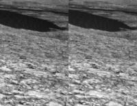
exceptionally bright vein segment sol1168 navcam and mastcam.
just a chance specular angle or did we break that rock? i dont see the usual track scrapes but some smooshed sand bulges at the foot of rocks and a couple bits and pieces are lying about also, nice little windtails on the pebbles to the right.. |
|
|
|
|
Nov 21 2015, 01:36 AM
Post
#88
|
|
|
Senior Member Group: Members Posts: 2428 Joined: 30-January 13 From: Penang, Malaysia. Member No.: 6853 |
Mission Update from Lauren Edgar - Sols 1170-1172: Studying bedrock, sand, and sky. LINK
QUOTE This week Curiosity has been driving towards the Bagnold Dunes and characterizing the bedrock and sand along the way. After a successful SAM methane experiment and 36.5 m drive on Sol 1168, Curiosity spent Sol 1169 recharging and assessing some of the local bedrock and dunes.
The weekend 3-sol plan starts with a number of environmental monitoring activities to assess atmospheric opacity and composition. The second sol includes several ChemCam and Mastcam activities to study the local bedrock and prepare for the upcoming dune investigation. Well also use Navcam to search for dust devils and monitor clouds and wind, and to monitor the deck of the rover to look for dust and sand accumulation. On the third sol well drive and take our standard post-drive imaging. The plan also includes SAM and CheMin activities for prepare for future sampling. Ill be on duty next week, so Ive been monitoring the weekend activities and getting ready for some exciting observations next week. |
|
|
|
|
Nov 21 2015, 08:14 AM
Post
#89
|
|
|
Senior Member Group: Members Posts: 2428 Joined: 30-January 13 From: Penang, Malaysia. Member No.: 6853 |
|
|
|
|
|
Nov 21 2015, 01:06 PM
Post
#90
|
||
|
Senior Member Group: Members Posts: 2830 Joined: 22-April 05 From: Ridderkerk, Netherlands Member No.: 353 |
Nice Navcam L view on Sol 1169.
Jan van Driel
|
|
|
|
|
|
|
Nov 21 2015, 05:25 PM
Post
#91
|
|
|
Senior Member Group: Members Posts: 2086 Joined: 13-February 10 From: Ontario Member No.: 5221 |
Memories of El Dorado at Gusev... Will Curiosity be actually able to measure their movement on the ground, some sort of time-lapse measurements at the edges, maybe?
|
|
|
|
|
Nov 21 2015, 05:42 PM
Post
#92
|
|
|
Solar System Cartographer Group: Members Posts: 10162 Joined: 5-April 05 From: Canada Member No.: 227 |
Almost certainly the rover would not be in one place long enough to see any movement of the dune. But it might be feasible to take high resolution MAHLI images showing individual grains several times over a few sols and get an estimate of the number of moving grains per square meter per sol, and relate it to wind speed.
Phil -------------------- ... because the Solar System ain't gonna map itself.
Also to be found posting similar content on https://mastodon.social/@PhilStooke Maps for download (free PD: https://upload.wikimedia.org/wikipedia/comm...Cartography.pdf NOTE: everything created by me which I post on UMSF is considered to be in the public domain (NOT CC, public domain) |
|
|
|
|
Nov 21 2015, 06:30 PM
Post
#93
|
|
|
Senior Member Group: Members Posts: 4247 Joined: 17-January 05 Member No.: 152 |
The movement is on the order of 1 m/yr, or 1 cm per few days, so conceivably we might see some changes at the edges. Of course that will depend on how well-defined (ie how sharp) those edges are. More importantly, it'll depend on how uniform that movement is over the Martian year. Most of the movement might happen in a relatively short interval, such as during the summer dust storm season, in which case we might be out of luck.
|
|
|
|
|
Nov 21 2015, 10:19 PM
Post
#94
|
|
|
Senior Member Group: Members Posts: 1044 Joined: 17-February 09 Member No.: 4605 |
Well Curiosity's ability to determine wind direction may be constrained, but in this area at least they will be able to correlate wind direction and velocity.
|
|
|
|
|
Nov 22 2015, 01:52 PM
Post
#95
|
||
|
Senior Member Group: Members Posts: 2830 Joined: 22-April 05 From: Ridderkerk, Netherlands Member No.: 353 |
The Navcam L images taken on Sol 1168 and Sol 1169 stitched together.
Jan van Driel
|
|
|
|
|
|
|
Nov 23 2015, 03:32 AM
Post
#96
|
|
|
Senior Member Group: Members Posts: 2428 Joined: 30-January 13 From: Penang, Malaysia. Member No.: 6853 |
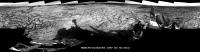
1158 L-MastCam, 27x1 preview of the 360 degree panorama (MS ICE and processed) Some exposure issues at the overlaps on the RH side
 Flickr Original Size 29184 x 1374 pixels LINK No Imgur mirror link (failed to UL properly) |
|
|
|
|
Nov 23 2015, 10:28 AM
Post
#97
|
|
|
Member Group: Members Posts: 362 Joined: 13-April 06 From: Malta Member No.: 741 |
I note that it was mentioned that the study of the upcoming Bagnold dune field is the first attempt of its sort with regards to Mars exploration. I recall the El Dorado dune at the Spirit landing sight in Colombia Hills . Is that a completely different structure or something similar?
|
|
|
|
|
Nov 23 2015, 11:53 AM
Post
#98
|
|
|
Senior Member Group: Members Posts: 2428 Joined: 30-January 13 From: Penang, Malaysia. Member No.: 6853 |
Just for fun.... The Bagnold Dunes: EDL to Sol 1171, Using browse MARDI images from the Analyst's Notebook and a revised JPL location map. I have annotated the approximate location of Bradbury Landing and sol 1172 onto the lower middle MARDI Frame.
 Flickr Original Size 6324 x 3066 pixels LINK Imgur mirror LINK |
|
|
|
|
Nov 23 2015, 03:55 PM
Post
#99
|
|
|
Member Group: Members Posts: 244 Joined: 2-March 15 Member No.: 7408 |
|
|
|
|
|
Nov 23 2015, 07:36 PM
Post
#100
|
|
|
Junior Member Group: Members Posts: 41 Joined: 27-May 09 From: Burgundy Member No.: 4798 |
QUOTE (climber @ Nov 9 2015, 12:54 PM) Do We have a meteorite (black rock) at 10h30 approx ? Effectively, it looks like an iron meteorite (sol1158). Sadly far away now. |
|
|
|
|

|
Lo-Fi Version | Time is now: 17th May 2024 - 09:20 AM |
|
RULES AND GUIDELINES Please read the Forum Rules and Guidelines before posting. IMAGE COPYRIGHT |
OPINIONS AND MODERATION Opinions expressed on UnmannedSpaceflight.com are those of the individual posters and do not necessarily reflect the opinions of UnmannedSpaceflight.com or The Planetary Society. The all-volunteer UnmannedSpaceflight.com moderation team is wholly independent of The Planetary Society. The Planetary Society has no influence over decisions made by the UnmannedSpaceflight.com moderators. |
SUPPORT THE FORUM Unmannedspaceflight.com is funded by the Planetary Society. Please consider supporting our work and many other projects by donating to the Society or becoming a member. |
|