Journey to Mt Sharp - Part 1: Site 7 to Waypoint 1, Sol324 [Jul4,'13] to Sol391 [Sep12,'13] |

  |
Journey to Mt Sharp - Part 1: Site 7 to Waypoint 1, Sol324 [Jul4,'13] to Sol391 [Sep12,'13] |
 Sep 12 2013, 08:25 PM Sep 12 2013, 08:25 PM
Post
#541
|
|
|
Senior Member  Group: Members Posts: 2346 Joined: 7-December 12 Member No.: 6780 |
After quite a while, here two enhanced (in a non-uniform way) MARDIs, Sol 388 and Sol 390:
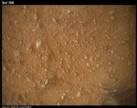 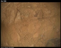 The Sol 390 image shows a broken thin layer or crust. |
 |
 
|
|
Sep 13 2013, 06:18 AM
Post
#542
|
|
 Member Group: Members Posts: 404 Joined: 5-January 10 Member No.: 5161 |
A bumpy ride on Sol 390:
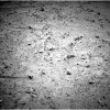 Is the NAVCAM held in a fixed position on these rides? |
|
|
|
|
Sep 14 2013, 06:29 AM
Post
#543
|
|
 Senior Member Group: Members Posts: 2428 Joined: 30-January 13 From: Penang, Malaysia. Member No.: 6853 |
|
|
|
|
|
Sep 15 2013, 07:22 AM
Post
#544
|
||
 Senior Member Group: Admin Posts: 3108 Joined: 21-December 05 From: Canberra, Australia Member No.: 615 |
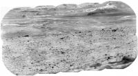
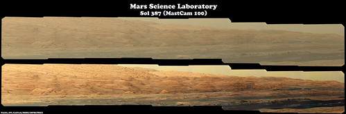
Sol387 Mastcam (right) image. Stunning detail

Note: Very compressed JPG to get it under the forum limits. Done with good 'ol Autostitch since I'm not at home much these days. |
|
|
|
|
|
|
Sep 15 2013, 09:01 AM
Post
#545
|
|||
 Senior Member Group: Members Posts: 2492 Joined: 15-January 05 From: center Italy Member No.: 150 |
QUOTE (Astro0 @ Sep 15 2013, 08:22 AM)  Stunning detail Indeed! I extracted and sharpened / contrast enhanced the rightmost portion showing the "Entry Point":
Edit1: I re-made the stitch starting from the 3 original frames, due to strong jpeg compression of Astro0 mosaic... Edit2: Added also a context map with angle covered by this mosaic (based on Joe's CuriosityRover Mapit!) -------------------- I always think before posting! - Marco -
|
||
|
|
|
||
|
Sep 15 2013, 09:34 AM
Post
#546
|
||
|
Senior Member Group: Admin Posts: 3108 Joined: 21-December 05 From: Canberra, Australia Member No.: 615 |
I really like the crater (crater-like?) formation here - cropped from a wider panorama.
Hope that Curiosity pops over for a closer look.
Again autostitched and compressed. |
|
|
|
|
|
|
Sep 15 2013, 11:26 AM
Post
#547
|
|
 Member Group: Members Posts: 161 Joined: 12-August 12 From: Hillsborough, NJ Member No.: 6546 |
387:
 http://www.flickr.com/photos/84750994@N05/...in/photostream/ 388 with anaglyph: 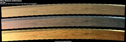 GigaPan: http://www.gigapan.com/gigapans/140196 http://www.flickr.com/photos/84750994@N05/...in/photostream/ -------------------- |
|
|
|
|
Sep 17 2013, 03:43 AM
Post
#548
|
|
 Member Group: Members Posts: 222 Joined: 7-August 12 From: Garberville, CA Member No.: 6500 |
Gave it my best shot but... looks like a no go on the The Long Baseline Sol 388 / 389 MC 100 combo...
Seems a 25 meter baseline for something as as close as the basin makes a full width panoramic anaglyph darn near impossible. Too dang close. Placing the channel focal point on any particular feature does allow for a reasonably good view of the feature itself and it's immediate surroundings, but the channel separation to almost anything increasingly farther or nearer spreads the channels so radically (within a relatively short distance) that holding focus becomes all but impossible. And forget about zooming in. I thought about skewing the channels laterally to try and narrow the separation but perspective goes wonky and the baseline-to-target angles vary so widely across the field that any consistency is out of the question. C'est la vie. That said - having both channels as layers in Photoshop and moving them around to center the focus on various parts of the panorama results in some shockingly deep perspectives but one must remained pretty well zoomed out so as not to lose focus. Here are two examples - (view them well zoomed out) -: Example 1 - Focus is on a rock pile at lower center of frame:  Example 2 - Focus is on another rock pile at lower center of frame:  Radical ay? The panos were stunningly captured... Here are the Full Resolution 2-D Versions (similarly projected, but not anaglyph aligned): Sol 388 (Full Resolution - 25,356 x 2183 pixels):  Sol 389 (Full Resolution - 25,400 x 2274 pixels):  Now if we could just get a stereo match for this here puppy, we'd be stylin'... ...first climb out of Darwin perhaps, at an 80 meter baseline and I'd buy the first round for everyone... Sol 387 - MC 100 - 9 Frame Pano -(Full Resolution - 9,772 x 1431): 
-------------------- "We shall not cease from exploration, and the end of all our exploring will be to arrive where we started and know the place for the first time." -T.S. Eliot
|
|
|
|
|
Sep 17 2013, 03:01 PM
Post
#549
|
||
|
Junior Member Group: Members Posts: 31 Joined: 1-July 13 From: Ithaca, NY Member No.: 6966 |
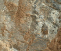
I think some glinting can be seen off of this rock at different angles (particularly the upper left corner of the image). Sol 387 MAHLI, cropped, and downsized to fit upload limits.
|
|
|
|
|
|
|
Oct 31 2014, 04:22 PM
Post
#550
|
||
|
Solar System Cartographer Group: Members Posts: 10150 Joined: 5-April 05 From: Canada Member No.: 227 |
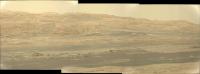
Belated post - I returned to these sols to make a ChemCam RMI mosaic of Ameto, a long-range target imaged on sol 327. This is the area at the foot of the steep slope up into Mt. Sharp, still about 7 or 8 km from where we are now (sol 794 as I do this). We will be in the upper right corner of this area about 2 years from now after crossing the 'foothills' region.
Phil
-------------------- ... because the Solar System ain't gonna map itself.
Also to be found posting similar content on https://mastodon.social/@PhilStooke NOTE: everything created by me which I post on UMSF is considered to be in the public domain (NOT CC, public domain) |
|
|
|
|
|
|

|
Lo-Fi Version | Time is now: 24th April 2024 - 06:11 PM |
|
RULES AND GUIDELINES Please read the Forum Rules and Guidelines before posting. IMAGE COPYRIGHT |
OPINIONS AND MODERATION Opinions expressed on UnmannedSpaceflight.com are those of the individual posters and do not necessarily reflect the opinions of UnmannedSpaceflight.com or The Planetary Society. The all-volunteer UnmannedSpaceflight.com moderation team is wholly independent of The Planetary Society. The Planetary Society has no influence over decisions made by the UnmannedSpaceflight.com moderators. |
SUPPORT THE FORUM Unmannedspaceflight.com is funded by the Planetary Society. Please consider supporting our work and many other projects by donating to the Society or becoming a member. |
|