A glimpse into the topography of the farside of Pluto, Can we use Pluto crescent images to see farside topography details? |

A glimpse into the topography of the farside of Pluto, Can we use Pluto crescent images to see farside topography details? |
 Oct 29 2021, 10:33 PM Oct 29 2021, 10:33 PM
Post
#1
|
||
 Member  Group: Members Posts: 127 Joined: 15-April 21 Member No.: 9009 |
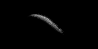
i did some heavy detail enhancement/extraction to this image below
 i figured out timing (around midnight EDT on July 15) of the image (after doing some research) and figured out the location of the south pole (with the help of Celesta), than i did additional modifications and aliments to get the below
also blended it with a already existing map (i also added in the charonshine stuff too (see https://arxiv.org/abs/2110.11976 ) chopped outoversaturated areas)   i am also wondering if anyone else has detail extracted crescent images i can cooperate into the maps above, plus i also could use feedback/consent on the above from the scientists/experts here |
|
 |
 
|
|
 TrappistPlanets A glimpse into the topography of the farside of Pluto Oct 29 2021, 10:33 PM
 Floyd There were some fine image results from the New Ho... Oct 29 2021, 11:28 PM
 TrappistPlanets QUOTE (Floyd @ Oct 30 2021, 12:28 AM) The... Oct 29 2021, 11:36 PM djellison QUOTE (TrappistPlanets @ Oct 29 2021, 04... Oct 30 2021, 02:58 AM TrappistPlanets QUOTE (djellison @ Oct 30 2021, 03:58 AM)... Oct 30 2021, 11:33 AM TrappistPlanets i'll try blurring, and noise reducing the heck... Oct 30 2021, 02:00 PM PDP8E Trappist! I admire your ideas and persistence... Oct 30 2021, 04:13 PM Antdoghalo There's barely anything but I can discern a pa... Oct 30 2021, 04:19 PM TrappistPlanets QUOTE (Antdoghalo @ Oct 30 2021, 05:19 PM... Oct 30 2021, 05:14 PM
  |

|
Lo-Fi Version | Time is now: 20th September 2024 - 09:12 AM |
|
RULES AND GUIDELINES Please read the Forum Rules and Guidelines before posting. IMAGE COPYRIGHT |
OPINIONS AND MODERATION Opinions expressed on UnmannedSpaceflight.com are those of the individual posters and do not necessarily reflect the opinions of UnmannedSpaceflight.com or The Planetary Society. The all-volunteer UnmannedSpaceflight.com moderation team is wholly independent of The Planetary Society. The Planetary Society has no influence over decisions made by the UnmannedSpaceflight.com moderators. |
SUPPORT THE FORUM Unmannedspaceflight.com is funded by the Planetary Society. Please consider supporting our work and many other projects by donating to the Society or becoming a member. |
|