Cape Tribulation, Sol 3744 (6Aug'14) - Sol 4077 (15Jul'15) |

  |
Cape Tribulation, Sol 3744 (6Aug'14) - Sol 4077 (15Jul'15) |
 Aug 6 2014, 09:30 PM Aug 6 2014, 09:30 PM
Post
#1
|
||||
 Senior Member  Group: Moderator Posts: 2262 Joined: 9-February 04 From: Melbourne - Oz Member No.: 16 |
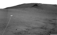
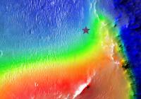
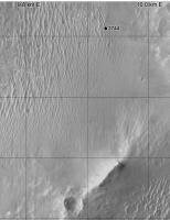
The ~85m drive on sol 3744 was uphill, starting the long climb of Cape Tribulation.
 The sol 3744 Drive:
Puts Opportunity about here on a plot with colour for elevation:
The view ahead:

-------------------- |
|||
 |
 
|
|||
|
Aug 6 2014, 10:29 PM
Post
#2
|
|||
|
Solar System Cartographer Group: Members Posts: 10192 Joined: 5-April 05 From: Canada Member No.: 227 |
Right! This is where I have it. (proper map update later)
Phil
-------------------- ... because the Solar System ain't gonna map itself.
Also to be found posting similar content on https://mastodon.social/@PhilStooke Maps for download (free PD: https://upload.wikimedia.org/wikipedia/comm...Cartography.pdf NOTE: everything created by me which I post on UMSF is considered to be in the public domain (NOT CC, public domain) |
||
|
|
|
||
|
Aug 9 2014, 03:29 PM
Post
#3
|
||
|
Solar System Cartographer Group: Members Posts: 10192 Joined: 5-April 05 From: Canada Member No.: 227 |
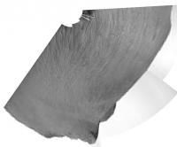
A circular view of a partial panorama from sol 3746.
Phil
-------------------- ... because the Solar System ain't gonna map itself.
Also to be found posting similar content on https://mastodon.social/@PhilStooke Maps for download (free PD: https://upload.wikimedia.org/wikipedia/comm...Cartography.pdf NOTE: everything created by me which I post on UMSF is considered to be in the public domain (NOT CC, public domain) |
|
|
|
|
|
|
Aug 9 2014, 11:18 PM
Post
#4
|
|
|
Member Group: Members Posts: 914 Joined: 4-September 06 From: Boston Member No.: 1102 |
Do we know if Opportunity will be traveling east or west around Wdowiak Ridge [name corrected]?
-------------------- |
|
|
|
|
Aug 9 2014, 11:32 PM
Post
#5
|
|
|
Senior Member Group: Members Posts: 3516 Joined: 4-November 05 From: North Wales Member No.: 542 |
It won't be east. The slopes on the inside of the crater are too steep. I don't know if they want to visit that outcrop but if they do I'd expect they'd sneak up on it from the right (west) where the gradients are less severe
|
|
|
|
|
Aug 10 2014, 12:03 AM
Post
#6
|
|
|
Member Group: Members Posts: 914 Joined: 4-September 06 From: Boston Member No.: 1102 |
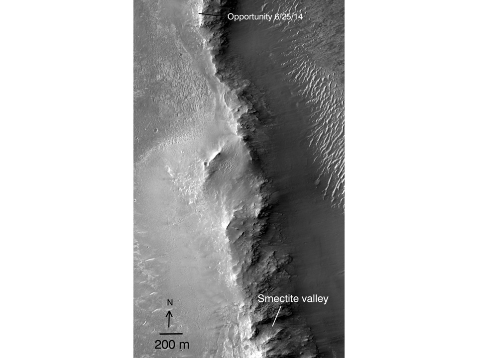
I'm not sure as the Eastern side is actually 200 m from the drop into the crater.
 -------------------- |
|
|
|
|
Aug 10 2014, 01:13 AM
Post
#7
|
|
 Senior Member Group: Members Posts: 4252 Joined: 17-January 05 Member No.: 152 |
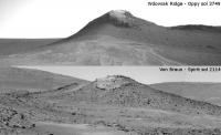
I'd say the east side is doable. Remember this image in a recent Crumpler blog that has a dashed green line following the eastern ridgeline up and then turning west to get behind Cape Stevens. There was no description of that dashed line, but we've also heard that several options were being considered.
|
|
|
|
|
Aug 10 2014, 01:45 PM
Post
#8
|
||
|
Senior Member Group: Members Posts: 2841 Joined: 22-April 05 From: Ridderkerk, Netherlands Member No.: 353 |
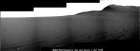
The Pancam L7 view on Sol 3746.
Jan van Driel
|
|
|
|
|
|
|
Aug 10 2014, 03:21 PM
Post
#9
|
|
|
Solar System Cartographer Group: Members Posts: 10192 Joined: 5-April 05 From: Canada Member No.: 227 |
OK... I was wrong. I saw the observation name cape Stevens and assumed it might be the rocky ridge south of us. Not so - it was a bit of outcrop near the rover. The big ridge is called Wdowiak Ridge. I will correct the map soon.
Phil -------------------- ... because the Solar System ain't gonna map itself.
Also to be found posting similar content on https://mastodon.social/@PhilStooke Maps for download (free PD: https://upload.wikimedia.org/wikipedia/comm...Cartography.pdf NOTE: everything created by me which I post on UMSF is considered to be in the public domain (NOT CC, public domain) |
|
|
|
|
Aug 11 2014, 03:10 PM
Post
#10
|
|
|
Senior Member Group: Members Posts: 3516 Joined: 4-November 05 From: North Wales Member No.: 542 |
What a picture!
http://qt.exploratorium.edu/mars/opportuni...__P1955L0M1.JPG |
|
|
|
|
Aug 11 2014, 03:35 PM
Post
#11
|
||
|
Senior Member Group: Members Posts: 4252 Joined: 17-January 05 Member No.: 152 |
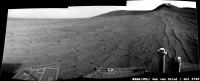
Yeah!
And with this last drive we've really climbed - we're getting back up towards the elevation of Broken Hills, as you can see from these hazcam views:
|
|
|
|
|
|
|
Aug 11 2014, 04:41 PM
Post
#12
|
||
|
Solar System Cartographer Group: Members Posts: 10192 Joined: 5-April 05 From: Canada Member No.: 227 |
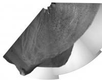
A quick circular view of sol 3749. The foreground features give a pretty good location.
Phil
-------------------- ... because the Solar System ain't gonna map itself.
Also to be found posting similar content on https://mastodon.social/@PhilStooke Maps for download (free PD: https://upload.wikimedia.org/wikipedia/comm...Cartography.pdf NOTE: everything created by me which I post on UMSF is considered to be in the public domain (NOT CC, public domain) |
|
|
|
|
|
|
Aug 11 2014, 06:10 PM
Post
#13
|
||
|
Senior Member Group: Members Posts: 2841 Joined: 22-April 05 From: Ridderkerk, Netherlands Member No.: 353 |
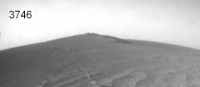
The Sol 3749 L0 Navcam view.
Jan van Driel
|
|
|
|
|
|
|
Aug 12 2014, 07:53 AM
Post
#14
|
||
|
Senior Member Group: Moderator Posts: 2262 Joined: 9-February 04 From: Melbourne - Oz Member No.: 16 |
Did anyone else get a feeling of deja-vu when seeing the navcams yesterday?

-------------------- |
|
|
|
|
|
|
Aug 12 2014, 12:59 PM
Post
#15
|
||
|
Senior Member Group: Moderator Posts: 2262 Joined: 9-February 04 From: Melbourne - Oz Member No.: 16 |
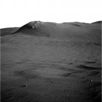
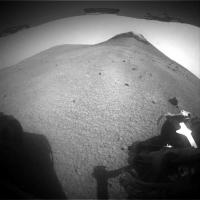
Closing in on Wdowiak Ridge!
Attached thumbnail(s)
-------------------- |
|
|
|
|
|
|

|
Lo-Fi Version | Time is now: 14th June 2024 - 12:19 AM |
|
RULES AND GUIDELINES Please read the Forum Rules and Guidelines before posting. IMAGE COPYRIGHT |
OPINIONS AND MODERATION Opinions expressed on UnmannedSpaceflight.com are those of the individual posters and do not necessarily reflect the opinions of UnmannedSpaceflight.com or The Planetary Society. The all-volunteer UnmannedSpaceflight.com moderation team is wholly independent of The Planetary Society. The Planetary Society has no influence over decisions made by the UnmannedSpaceflight.com moderators. |
SUPPORT THE FORUM Unmannedspaceflight.com is funded by the Planetary Society. Please consider supporting our work and many other projects by donating to the Society or becoming a member. |
|