Unmanned Spaceflight.com > All posts by a member
| Posted on: Mar 25 2006, 07:09 PM | |
|
Newbie  Group: Members Posts: 4 Joined: 2-November 05 Member No.: 540 |
|
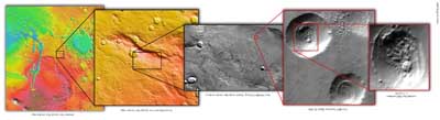
| Forum: MRO 2005 · Post Preview: #47583 · Replies: 224 · Views: 140198 |
| Posted on: Nov 2 2005, 11:51 PM | ||
|
Newbie Group: Members Posts: 4 Joined: 2-November 05 Member No.: 540 |
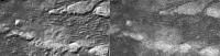
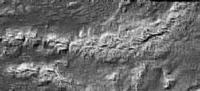
QUOTE (volcanopele @ Nov 2 2005, 12:41 PM) okay, if it helps you visualize the data, that's fine. But quanitatively, it isn't as useful because there is definitely not a one-for-one correlation between SAR brightness and altitude. I just wanted to make the point that one has to be careful when looking at that image you produced,  Actually this is an interesting discussion. Gonna push back a little - not to be antagonistic - but to present a point-of-view and gain some insight. I think I could argue that we should be just as careful looking at the "raw" SAR image. The problem is that the process actually creates false "shadow" artifacts that cause us to see the image in 3D relief - with an assumed light-source from the "up" direction. Our brains perceive the "dunes" as sticking up because they have a radar shadow on their "down" side. I think that by presenting an alternate ("enhanced" is the wrong word I suppose) version of the image we may gain something. My point in the previous post was that by processing the image the "dunes" begin to look more like "rifts". By presenting the alternative look, everyone has a chance to realize that they might have percieved the "raw" SAR image incorrectly - something they may not have realized otherwise. I think your point would be that perhaps by presenting those images as "enhanced" people might have assumed they were more accurate than the "raw" images. I would concur (even as I hold to the possibility that they indeed might be more accurate.) Thanks for your comments and the chance to chat about it. Honestly not trying to stir anything up. I am open to the fact that I might not have an accurate understanding of the SAR image data.
|
|
| Forum: Titan · Post Preview: #25316 · Replies: 101 · Views: 86269 |
| Posted on: Nov 2 2005, 08:19 PM | |
|
Newbie Group: Members Posts: 4 Joined: 2-November 05 Member No.: 540 |
QUOTE (volcanopele @ Nov 2 2005, 09:22 AM) wohba: remember, brightness in SAR images is based on many different factors, not so much altitude. These factors include the roughness of terrain, the dielectic constant (and thus composition), volume scattering, and slope. So making it a DEM isn't telling us much. Good point. I understand. I do think there is value in looking at the raw data in alternate forms. After doing the enhancements, the "dunes' begin to look more run-off related which seems to make more sense. And it is easier to see the landmasses between the dunes as "landmasses". The enhancements help me see alternate interpretations from the data that I had problems visualizing otherwise. |
| Forum: Titan · Post Preview: #25299 · Replies: 101 · Views: 86269 |
| Posted on: Nov 2 2005, 05:32 AM | ||
|
Newbie Group: Members Posts: 4 Joined: 2-November 05 Member No.: 540 |
Enhanced the radar images a bit to bring out height of features based on grayscale. http://wohba.com/2005/11/another-titan-pass.html
|
|
| Forum: Titan · Post Preview: #25239 · Replies: 101 · Views: 86269 |
 New Replies New Replies No New Replies No New Replies Hot Topic (New) Hot Topic (New) Hot Topic (No New) Hot Topic (No New) |
 Poll (New) Poll (New) Poll (No New) Poll (No New) Locked Topic Locked Topic Moved Topic Moved Topic |

|
Lo-Fi Version | Time is now: 29th April 2024 - 04:33 PM |
|
RULES AND GUIDELINES Please read the Forum Rules and Guidelines before posting. IMAGE COPYRIGHT |
OPINIONS AND MODERATION Opinions expressed on UnmannedSpaceflight.com are those of the individual posters and do not necessarily reflect the opinions of UnmannedSpaceflight.com or The Planetary Society. The all-volunteer UnmannedSpaceflight.com moderation team is wholly independent of The Planetary Society. The Planetary Society has no influence over decisions made by the UnmannedSpaceflight.com moderators. |
SUPPORT THE FORUM Unmannedspaceflight.com is funded by the Planetary Society. Please consider supporting our work and many other projects by donating to the Society or becoming a member. |
|