Iapetus Far-Encounter between March 25 and April 18 2006 |

 Unmanned Spaceflight.com > Outer Solar System > Saturn > Cassini Huygens > Cassini's ongoing mission and raw images
  |
Iapetus Far-Encounter between March 25 and April 18 2006 |
 Mar 30 2006, 06:15 PM Mar 30 2006, 06:15 PM
Post
#31
|
|
 Member  Group: Members Posts: 288 Joined: 28-September 05 From: Orion arm Member No.: 516 |
Hello,
another 9 images arrived from CASSINI. Here one takeout: 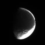 Date: 2006/03/28 Distance: 2.188.203 km Filters: CL1 and CL2 Bye. |
 |
 
|
|
Apr 1 2006, 10:02 AM
Post
#32
|
|
|
Member Group: Members Posts: 288 Joined: 28-September 05 From: Orion arm Member No.: 516 |
Hi,
another 10 far-distance images were taken from Iapetus. Here one takeout: 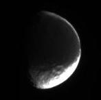 Date: 2006/03/29 Distance: 2.103.960 km Filters: CL1 and CL2 Bye. |
|
|
|
|
Apr 1 2006, 04:20 PM
Post
#33
|
|
|
Member Group: Members Posts: 509 Joined: 2-July 05 From: Calgary, Alberta Member No.: 426 |
This distant flyby could turn out to be pretty interesting. There look to be some interesting gradations in the colour of Cassini Regio in Iapetus south-leading quarter-sphere (demihemisphere?).
In a few of those distant shots TritonAntares has posted, you can see some of the bellyband mountains on the limb. Amazing how tall those things are. |
|
|
|
|
Apr 1 2006, 05:41 PM
Post
#34
|
|
 Member Group: Members Posts: 114 Joined: 6-November 05 From: So. Maryland, USA Member No.: 544 |
QUOTE (Rob Pinnegar @ Apr 1 2006, 11:20 AM)  In a few of those distant shots TritonAntares has posted, you can see some of the bellyband mountains on the limb. Amazing how tall those things are. I can't see the bellyband, but a few of these shots do show the Moat's central peak very clearly on the limb. Michael |
|
|
|
|
Apr 1 2006, 06:07 PM
Post
#35
|
|
|
Member Group: Members Posts: 509 Joined: 2-July 05 From: Calgary, Alberta Member No.: 426 |
QUOTE (Michael Capobianco @ Apr 1 2006, 10:41 AM) I can't see the bellyband, but a few of these shots do show the Moat's central peak very clearly on the limb. Hmmm. You might be right about that one, Michael. I just sort of assumed that the peak on the limb was one of the bellyband peaks. It could very well be the Moat's central peak instead. |
|
|
|
|
Apr 1 2006, 08:26 PM
Post
#36
|
||||
|
Member Group: Members Posts: 288 Joined: 28-September 05 From: Orion arm Member No.: 516 |
QUOTE (Rob Pinnegar @ Apr 1 2006, 06:20 PM) In a few of those distant shots TritonAntares has posted, you can see some of the bellyband mountains on the limb. Amazing how tall those things are. QUOTE (Michael Capobianco @ Apr 1 2006, 07:41 PM) I can't see the bellyband, but a few of these shots do show the Moat's central peak very clearly on the limb. QUOTE (Rob Pinnegar @ Apr 1 2006, 08:07 PM) Hmmm. You might be right about that one, Michael. I just sort of assumed that the peak on the limb was one of the bellyband peaks. It could very well be the Moat's central peak instead. I always wondered about the trace of the bellyband in Iapetus eastern hemisphere. It's so obvious in Steve Albers map:
I marked the supposed course of the bellyband in the above mentioned region south of the 'Snowman' of an enlarged map. The central peak of 'Snowman A' is also encircled.
Compare with this image taken on Jan. 22, 2006, at a distance of approximately 1.3 million km:
You can easily see the enormous height of the Moat's central mountain. But there is no hint due shadow casting for large mountains at the marked line of the supposed bellyband path, but south of it seems to be a huge ridge (ellipse) casting a shadow to NNW like the inner crater rim of 'Snowman A'. Therefore the bellyband in Iapetus eastern hemisphere must be quite low, if it exists at all and this line in Steve Albers map is artifical there. 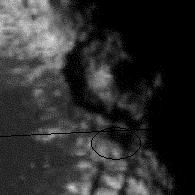 Bye. |
|||
|
|
|
|||
|
Apr 1 2006, 08:50 PM
Post
#37
|
|
|
Member Group: Members Posts: 114 Joined: 6-November 05 From: So. Maryland, USA Member No.: 544 |
[quote name='TritonAntares' date='Apr 1 2006, 03:26 PM' post='48836']
But there is no hint due shadow casting for large mountains at the marked line of the supposed bellyband path, but south of it seems to be a huge ridge (ellipse) casting a shadow to NNW like the inner crater rim of 'Snowman A'. Therefore the bellyband in Iapetus eastern hemisphere must be quite low, if it exists at all and this line in Steve Albers map is artifical there. Yes. Although there is a suggestive bright line there, it seems to be just a coincidence. The ridge you highlight appears to be part of an interesting crosshatching of ridges to the south, although it's very hard to make out what's going on at these low resolutions. Michael |
|
|
|
|
Apr 1 2006, 10:48 PM
Post
#38
|
||
|
Member Group: Members Posts: 288 Joined: 28-September 05 From: Orion arm Member No.: 516 |
Hello!
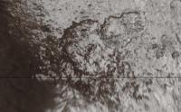
QUOTE The ridge you highlight appears to be part of an interesting crosshatching of ridges to the south, although it's very hard to make out what's going on at these low resolutions. You mean this mysterious doublecross structure:
What is this? Tectonic rifts and ridges caused by the 'Snowman'? Something connected with the equatorial ridge? Or...?  Bye. |
|
|
|
|
|
|
Apr 2 2006, 12:51 AM
Post
#39
|
|
 Senior Member Group: Members Posts: 1628 Joined: 5-March 05 From: Boulder, CO Member No.: 184 |
Yes I agree the white line on the E edge of CR is a real albedo feature, though maybe a fortituous coincidence. The stereo imagery I had once shown didn't show any conclusive ridge there, though it might not completely be ruled out either. I am starting to reprocess some of the Saturnshine images in the hope of improving the noise reduction and resolution so that might help slightly. If I can add do this and find additional Saturnshine images from that encounter it could help both in the map and the stereo imaging.
The snowcapped peaks on the W side of CR do look more realistic as part of the bellyband. All this to preface what are an interesting set of images coming in as we speak. -------------------- Steve [ my home page and planetary maps page ]
|
|
|
|
|
Apr 2 2006, 03:18 AM
Post
#40
|
||
|
Member Group: Members Posts: 114 Joined: 6-November 05 From: So. Maryland, USA Member No.: 544 |
QUOTE (TritonAntares @ Apr 1 2006, 05:48 PM) Hello! You mean this mysterious doublecross structure:
What is this? Tectonic rifts and ridges caused by the 'Snowman'? Something connected with the equatorial ridge? Or...? Tic Tac Toe board?  Michael |
|
|
|
|
|
|
Apr 2 2006, 10:34 AM
Post
#41
|
||
 Senior Member Group: Members Posts: 3648 Joined: 1-October 05 From: Croatia Member No.: 523 |
QUOTE (TritonAntares @ Apr 1 2006, 11:48 PM) You mean this mysterious doublecross structure:
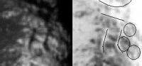
What is this? Tectonic rifts and ridges caused by the 'Snowman'? Something connected with the equatorial ridge? Or...? This reminds me of the discussion on You-Know-What looking hill on Mars that was identified in Viking imagery years ago. Seems that you're really trying to pull out too much information out of such a low-res view. For all we know, higher resolution might make this nothing like a double-cross. Even now, that lower horizontal line you marked seems to end in a small crater on the right (you did extend it into the crater itself) , while the upper line follows its outer rim. The right vertical line thus outlines the interior wall of the crater. Human eye often likes to see patterns when there aren't any. -------------------- |
|
|
|
|
|
|
Apr 2 2006, 01:15 PM
Post
#42
|
||
|
Member Group: Members Posts: 288 Joined: 28-September 05 From: Orion arm Member No.: 516 |
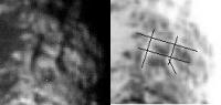
QUOTE (ugordan @ Apr 2 2006, 12:34 PM) This reminds me of the discussion on You-Know-What looking hill on Mars that was identified in Viking imagery years ago. Seems that you're really trying to pull out too much information out of such a low-res view. For all we know, higher resolution might make this nothing like a double-cross. Even now, that lower horizontal line you marked seems to end in a small crater on the right (you did extend it into the crater itself) , while the upper line follows its outer rim. The right vertical line thus outlines the interior wall of the crater. Human eye often likes to see patterns when there aren't any. You're definitely right, these low resolution images lead to misinterpretations. The double-cross is for sure some artifical structure, pretenced by the human eye. After a 'second look' at the region I could recognize 3 craters (one of them you mentioned), the southern rim of 'Snowman A', the horizontal structure south of it and two vertical structures (parts of the double-cross):
Due to dark shadow casting the three structures should be ridges... Bye. |
|
|
|
|
|
|
Apr 2 2006, 02:07 PM
Post
#43
|
|
|
Senior Member Group: Members Posts: 1276 Joined: 25-November 04 Member No.: 114 |
Raws are up for April 1,2006
|
|
|
|
|
Apr 2 2006, 06:56 PM
Post
#44
|
|
|
Member Group: Members Posts: 288 Joined: 28-September 05 From: Orion arm Member No.: 516 |
Hi,
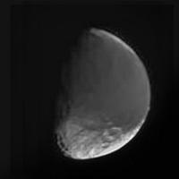
yes, the next 18 images arrived. Here two takeouts: 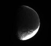 Date: 2006/03/30 Distance: 2.000.937 km Filters: CL1 and CL2 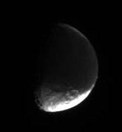 Date: 2006/04/01 Distance: 1.867.635 km Filters: CL1 and CL2 Probably a large mountain visible at the right rim... CASSINI is slowly getting closer... Bye. |
|
|
|
|
Apr 3 2006, 02:08 AM
Post
#45
|
||
|
Solar System Cartographer Group: Members Posts: 10153 Joined: 5-April 05 From: Canada Member No.: 227 |
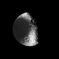
This is the latest view of Iapetus. It's a composite of six images from the latest batch, combined to reduce the JPEG artifacts and with a bit of selective contrast fiddling as well.
Phil
-------------------- ... because the Solar System ain't gonna map itself.
Also to be found posting similar content on https://mastodon.social/@PhilStooke Maps for download (free PD: https://upload.wikimedia.org/wikipedia/comm...Cartography.pdf NOTE: everything created by me which I post on UMSF is considered to be in the public domain (NOT CC, public domain) |
|
|
|
|
|
|

|
Lo-Fi Version | Time is now: 27th April 2024 - 01:18 AM |
|
RULES AND GUIDELINES Please read the Forum Rules and Guidelines before posting. IMAGE COPYRIGHT |
OPINIONS AND MODERATION Opinions expressed on UnmannedSpaceflight.com are those of the individual posters and do not necessarily reflect the opinions of UnmannedSpaceflight.com or The Planetary Society. The all-volunteer UnmannedSpaceflight.com moderation team is wholly independent of The Planetary Society. The Planetary Society has no influence over decisions made by the UnmannedSpaceflight.com moderators. |
SUPPORT THE FORUM Unmannedspaceflight.com is funded by the Planetary Society. Please consider supporting our work and many other projects by donating to the Society or becoming a member. |
|