T39 (December 20th 2007 / Rev 54) |

  |
T39 (December 20th 2007 / Rev 54) |
 Dec 26 2007, 01:57 PM Dec 26 2007, 01:57 PM
Post
#16
|
|
|
Member  Group: Members Posts: 813 Joined: 29-December 05 From: NE Oh, USA Member No.: 627 |
QUOTE (rlorenz @ Dec 22 2007, 09:06 AM)  Caitlin Griffith made first spectroscopic detection of clouds on Titan with the 1995 outburst. But an HST observation very close to that time (just a couple of weeks different, so maybethe same outburst) shows cloud system at 40 degrees NORTH - nowhere near the south pole(there is a map showing this cloud in Lifting Titan's Veil..) rlorenz.. Thanks so much for the response.. I'll have to go back through the literature..... I had the impression the larger outbursts had been determined to be similar to the south pole clouds seen by CASSINI in 2004. If the south pole clouds were methane cumulus clouds, wonder if the downpours made it to the surface? I believe you have written on the physics of this, and that the air would become saturated enough to allow the drops to hit the surface. If that is the case, and these storms were a common summer time feature over the pole, what sort of erosion will we see at the surface? Really wanna see this SAR!!!! Craig |
 |
 
|
|
Jan 4 2008, 08:44 AM
Post
#17
|
|
 Member Group: Members Posts: 714 Joined: 3-January 08 Member No.: 3995 |
.
|
|
|
|
|
Jan 4 2008, 06:10 PM
Post
#18
|
|
 Senior Member Group: Moderator Posts: 3233 Joined: 11-February 04 From: Tucson, AZ Member No.: 23 |
I don't think you are imagining ALL of those apparent rivers. The thicker one flow south looks plenty real.
-------------------- &@^^!% Jim! I'm a geologist, not a physicist!
The Gish Bar Times - A Blog all about Jupiter's Moon Io |
|
|
|
|
Jan 4 2008, 06:28 PM
Post
#19
|
|
|
Merciless Robot Group: Admin Posts: 8783 Joined: 8-December 05 From: Los Angeles Member No.: 602 |
Agreed...if I didn't know better, it almost looks like an estuary! Welcome, Gladstoner.

-------------------- A few will take this knowledge and use this power of a dream realized as a force for change, an impetus for further discovery to make less ancient dreams real.
|
|
|
|
|
Jan 4 2008, 07:05 PM
Post
#20
|
|
 Senior Member Group: Moderator Posts: 2785 Joined: 10-November 06 From: Pasadena, CA Member No.: 1345 |
Nice.
And if we got lucky, the swath hit the transition between the fractal lake morphology and the smooth shoreline morphology. I can't wait 'till it gets released! -Mike -------------------- Some higher resolution images available at my photostream: http://www.flickr.com/photos/31678681@N07/
|
|
|
|
|
Jan 4 2008, 10:07 PM
Post
#21
|
|
|
Junior Member Group: Members Posts: 40 Joined: 11-November 05 Member No.: 550 |
I share your eager anticipation, looks like the radar traversed a very interesting region.
Is that part of Mezzoramia at the far end of the swathe? |
|
|
|
|
Jan 8 2008, 09:15 PM
Post
#22
|
|
|
Senior Member Group: Moderator Posts: 3233 Joined: 11-February 04 From: Tucson, AZ Member No.: 23 |
QUOTE (volcanopele @ Jan 4 2008, 11:10 AM) I don't think you are imagining ALL of those apparent rivers. The thicker one flow south looks plenty real. Well, what do you know  http://photojournal.jpl.nasa.gov/jpeg/PIA10219.jpg -------------------- &@^^!% Jim! I'm a geologist, not a physicist!
The Gish Bar Times - A Blog all about Jupiter's Moon Io |
|
|
|
|
Jan 8 2008, 09:24 PM
Post
#23
|
|
|
Senior Member Group: Moderator Posts: 3233 Joined: 11-February 04 From: Tucson, AZ Member No.: 23 |
QUOTE (volcanopele @ Dec 21 2007, 04:16 PM) har har, if that is a dune field, I owe you a beer. Well, it's not a dune field, isn't an liquid-filled lake either... http://photojournal.jpl.nasa.gov/catalog/PIA10218 -------------------- &@^^!% Jim! I'm a geologist, not a physicist!
The Gish Bar Times - A Blog all about Jupiter's Moon Io |
|
|
|
|
Jan 8 2008, 10:23 PM
Post
#24
|
|
|
Member Group: Members Posts: 813 Joined: 29-December 05 From: NE Oh, USA Member No.: 627 |
What Tha !!!!!!
Titan trumps us again....... but as I noted in post #16, the methane rain on these plains certainly tore up the terrain (erosion from the summer cloud bursts). Craig |
|
|
|
|
Jan 8 2008, 10:33 PM
Post
#25
|
|
|
Founder Group: Chairman Posts: 14432 Joined: 8-February 04 Member No.: 1 |
Totally uninformed observers comment...
It looks just like the Severn Estuary - complete with the bow south of Gloucester. http://maps.google.co.uk/?ie=UTF8&ll=5...p;z=11&om=1 |
|
|
|
| Guest_Sunspot_* |
Jan 8 2008, 11:08 PM
Post
#26
|
|
Guests |
Some parts of the image look like the formations seen in some of the Salt Marshes in East Anglia.
|
|
|
|
|
Jan 8 2008, 11:10 PM
Post
#27
|
|
 Member Group: Members Posts: 610 Joined: 23-February 07 From: Occasionally in Columbia, MD Member No.: 1764 |
QUOTE (volcanopele @ Jan 8 2008, 04:24 PM) Well, it's not a dune field, isn't an liquid-filled lake either... http://photojournal.jpl.nasa.gov/catalog/PIA10218 Sufficiently nondunelike to keep you out of owing me a beer, I guess. The relative lack of lakes is intriguing, and rather contrary to the CICLOPS propaganda put out before the encounter... |
|
|
|
|
Jan 8 2008, 11:20 PM
Post
#28
|
|
|
Senior Member Group: Moderator Posts: 2785 Joined: 10-November 06 From: Pasadena, CA Member No.: 1345 |
And check this out!
http://photojournal.jpl.nasa.gov/catalog/PIA10219 Look how the (wet muds?) display channels that look like sapping. And as you go further south in the image, the sapped channels get wider and wider, until they turn into narrowing ridges (wider valleys thus narrower ridges). Until only the thin ridges are left. Just like a really cool Escher drawing. Wow! -Mike -------------------- Some higher resolution images available at my photostream: http://www.flickr.com/photos/31678681@N07/
|
|
|
|
|
Jan 8 2008, 11:36 PM
Post
#29
|
||
|
Junior Member Group: Members Posts: 64 Joined: 11-October 05 Member No.: 525 |
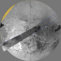
Approximate location:
Attached thumbnail(s)
|
|
|
|
|
|
|
Jan 8 2008, 11:39 PM
Post
#30
|
|
|
Senior Member Group: Moderator Posts: 3233 Joined: 11-February 04 From: Tucson, AZ Member No.: 23 |
QUOTE (rlorenz @ Jan 8 2008, 04:10 PM) Sufficiently nondunelike to keep you out of owing me a beer, I guess. The relative lack of lakes is intriguing, and rather contrary to the CICLOPS propaganda put out before the encounter... But you still missed the two coolest lakes of all down there But you did catch a few of our lakes. -------------------- &@^^!% Jim! I'm a geologist, not a physicist!
The Gish Bar Times - A Blog all about Jupiter's Moon Io |
|
|
|
|

|
Lo-Fi Version | Time is now: 26th April 2024 - 05:32 PM |
|
RULES AND GUIDELINES Please read the Forum Rules and Guidelines before posting. IMAGE COPYRIGHT |
OPINIONS AND MODERATION Opinions expressed on UnmannedSpaceflight.com are those of the individual posters and do not necessarily reflect the opinions of UnmannedSpaceflight.com or The Planetary Society. The all-volunteer UnmannedSpaceflight.com moderation team is wholly independent of The Planetary Society. The Planetary Society has no influence over decisions made by the UnmannedSpaceflight.com moderators. |
SUPPORT THE FORUM Unmannedspaceflight.com is funded by the Planetary Society. Please consider supporting our work and many other projects by donating to the Society or becoming a member. |
|