Printable Version of Topic
Click here to view this topic in its original format
Unmanned Spaceflight.com _ Jupiter _ Jovian Maps
Posted by: Jeffrey Mar 3 2009, 02:15 PM
As you may have guessed, my interest in planetary maps has peaked again, and I think it's time to update all my Voyager-sourced maps. The question is, should I buy the latest USGS maps of Io, Callisto, Ganymede, Europa etc. or are new maps coming anytime soon?
Jeffrey
Posted by: CAP-Team Mar 4 2009, 02:42 PM
Why buy maps while they are all public available for personal use?
For example: http://laps.fsl.noaa.gov/albers/sos/sos.html
Posted by: Jeffrey Mar 4 2009, 03:33 PM
full inline quote removed - ADMIN
Because buying maps is cheaper than printing them out.
Posted by: DrShank Apr 23 2009, 02:34 AM

Because buying maps is cheaper than printing them out.
If you wait till december, the Atlas of the Galilean Satellites will be available from Cambridge Press. The manuscript was sent out today!
paul
Posted by: Phil Stooke Apr 23 2009, 03:38 AM
Excellent news!
And another reply to the first in this thread:
-----
"Why buy maps while they are all public available for personal use?
For example: http://laps.fsl.noaa.gov/albers/sos/sos.html"
-----
The printed maps are a lot more than the plain images Steve Albers has produced. No offence, Steve, they are excellent image maps and they appear in a very timely fashion, and the projection is ideal for the computer rendering business. But the printed map from USGS contains more information, including feature names, a labelled grid, and a considerable amount of information about how it was made, the data sources, the map projection, and so on. Many users will prefer the map projection used for the printed map, which doesn't distort the poles as a Simple Cylindrical projection does. Besides which, as any cartophile will tell you, a hard copy map is a beautiful artifact which you just gotta have! A digital map is a tool, you can do things with it. But a paper map is a work of art. (drool!)
Phil
Posted by: PhilCo126 Apr 23 2009, 07:04 AM
Paul, was that the book supposed to be available March 2008 ?
ISBN-13: 978-0521868358
Posted by: DrShank May 2 2009, 04:56 AM
ISBN-13: 978-0521868358
woooah! Sold out! excellent. (actually first ive seen that they made this public but yeah the manuscript went in last week
and now has to go through production. I will send out some details when I know more about page counts, etc.
but several hundred figures will be in it.
p
Posted by: scalbers Feb 27 2012, 08:34 PM
Greetings,
Here's an update on the feature map of Io I posted in another thread. Among other things more features are now being shown:
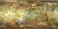
|
Full Resolution: http://laps.noaa.gov/albers/sos/features/combined_io_lon_180_center.png
Steve
Posted by: TheAnt Feb 27 2012, 10:18 PM
Thank you very much for posting these maps. I am especially happy for this one of Io, also the one of Mercury you posted in another thread..
Posted by: scalbers Mar 11 2012, 02:46 PM
TheAnt you're most welcome. Here's what I have at this point for Europa, with features larger than 40km. This is improved over the one I posted in the Image Processing thread. The feature labels are now rotated and offset for the Linea and such. Europa needed this more than any other planet/satellite as you might imagine.
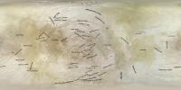
|
Full resolution here: http://laps.noaa.gov/albers/sos/features/combined_europa_lon_zero_center.png
Steve
Posted by: MarcF Aug 6 2013, 11:01 AM
New Names for three Sulci and one Regio on Ganymede :
Melotte Regio: 201.1° W to 290.5 W and 22.06 N to 42.8 S.
Babylon Sulci: 61° W to 130 W and 12 N to 55 S.
Borsippa Sulcus: 304° W to 73 W and 18 S to 77 S.
Mummu Sulci: 160° W to 222 W and 13 S to 65 S.
http://astrogeology.usgs.gov/HotTopics/index.php?/archives/495-New-Names-for-Three-Sulci-and-One-Regio-on-Ganymede.html
Pleased to see that things are going on, even if there is no current mission in the Jovian system.
Regards,
Marc.
Posted by: MarcF Feb 12 2014, 10:41 PM
Largest Solar System Moon Detailed in Geologic Map :
http://www.nasa.gov/jpl/news/ganymede20140212/index.html#.Uvv4QkpvASw
"A group of scientists led by Geoffrey Collins of Wheaton College has produced the first global geologic map of Ganymede, Jupiters seventh moon. The map combines the best images obtained during flybys conducted by NASA's Voyager 1 and 2 spacecraft (1979) and Galileo orbiter (1995 to 2003) and is now published by the U. S. Geological Survey as a global map. It technically illustrates the varied geologic character of Ganymedes surface and is the first global, geologic map of this icy, outer-planet moon."
Best regards,
Marc.
Posted by: TheAnt Feb 15 2014, 08:33 AM
http://www.jhuapl.edu/newscenter/pressreleases/2014/140212.asp presentation on the same subject, the link added since it were that institution that did the work.
Powered by Invision Power Board (http://www.invisionboard.com)
© Invision Power Services (http://www.invisionpower.com)