Spirit Route Map, Small and Large Scales |

  |
Spirit Route Map, Small and Large Scales |
 Mar 14 2006, 03:12 PM Mar 14 2006, 03:12 PM
Post
#376
|
|
 Member  Group: Members Posts: 267 Joined: 5-February 06 Member No.: 675 |
QUOTE (Shaka @ Mar 10 2006, 03:43 PM)  Yes, Bill, that's a start. Probably JPL hasn't got much more than this, since they are in the midst of a long-baseline 3D shoot of the hill now. If Korolev gets us into the "Safe Zone" then things are looking good, I would say. The next question is: where is the bottom of the safe zone?... I imagine the long baseline 3D shoot will generate a good enough Digital Elevation Model to compute slope and insolation parameters at the visible face of McCool Hill. Probably the planners have something like that in mind, which will be very useful assuming the wheel problems work out.If such a DEM were made generally available, I'm sure interested parties (Helvick, are you interested?  ) could map the expected power input at various points on the hill at various times of year and get not just the safe zone, but also maps of surplus power for mobility and research. ) could map the expected power input at various points on the hill at various times of year and get not just the safe zone, but also maps of surplus power for mobility and research.
|
 |
 
|
|
Mar 14 2006, 03:28 PM
Post
#377
|
|
|
Founder Group: Chairman Posts: 14432 Joined: 8-February 04 Member No.: 1 |
I inquired about getting the DEM of the MOC stereo pairs to do some nice flyarounds etc, but didn't get a response sadly.
Doug |
|
|
|
|
Mar 14 2006, 05:26 PM
Post
#378
|
|
 Dublin Correspondent Group: Admin Posts: 1799 Joined: 28-March 05 From: Celbridge, Ireland Member No.: 220 |
QUOTE (Steve @ Mar 14 2006, 03:12 PM) If such a DEM were made generally available, I'm sure interested parties (Helvick, are you interested? ) could map the expected power input at various points on the hill at various times of year and get not just the safe zone, but also maps of surplus power for mobility and research.That has always been the plan. 
|
|
|
|
|
Mar 16 2006, 10:29 AM
Post
#379
|
|
|
Senior Member Group: Moderator Posts: 4279 Joined: 19-April 05 From: .br at .es Member No.: 253 |
|
|
|
|
|
Mar 16 2006, 12:56 PM
Post
#380
|
|
 Member Group: Members Posts: 136 Joined: 13-October 05 From: Malibu, CA Member No.: 527 |
|
|
|
|
|
Mar 17 2006, 09:49 AM
Post
#381
|
||
|
Senior Member Group: Moderator Posts: 4279 Joined: 19-April 05 From: .br at .es Member No.: 253 |
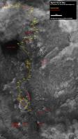
Route map, updated to sol 782.
|
|
|
|
|
|
|
Mar 21 2006, 06:34 AM
Post
#382
|
|
|
Member Group: Members Posts: 136 Joined: 13-October 05 From: Malibu, CA Member No.: 527 |
This is no 'route map' - but it is a map, such as it is... the Google Mars Map.
It doesn't work too well, doesn't go back to prior images well, and fails other desired features too - but, it is better than nothing, and better than others in some ways. |
|
|
|
|
Mar 22 2006, 02:26 PM
Post
#383
|
||
|
Senior Member Group: Moderator Posts: 4279 Joined: 19-April 05 From: .br at .es Member No.: 253 |
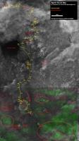
Route map, updated to sol 787.
That makes for aprox. 3m NE since my last update (sol 782). 
|
|
|
|
|
|
|
Mar 28 2006, 05:42 PM
Post
#384
|
||
|
XYL Code Genius Group: Members Posts: 138 Joined: 23-November 05 Member No.: 566 |
Slow days... so here is anaglyph map, for a change.
Attached thumbnail(s)
|
|
|
|
|
|
|
Apr 3 2006, 04:23 AM
Post
#385
|
|
 Senior Member Group: Members Posts: 1229 Joined: 24-December 05 From: The blue one in between the yellow and red ones. Member No.: 618 |
QUOTE (MaxSt @ Mar 28 2006, 07:42 AM) Slow days... so here is anaglyph map, for a change. Slow days could now be a substantial understatement. I would be interested to see a highly detailed Spirit Route Map for the last two weeks. I think it would be pretty worrying. It's not that we have so far to go, it's that our rate of progress is frighteningly slow. I guess it does show how the sand can sneak up on you. Maybe MSL should have deployable sandshoes.
-------------------- My Grandpa goes to Mars every day and all I get are these lousy T-shirts!
|
|
|
|
|
Apr 3 2006, 08:50 AM
Post
#386
|
||
|
Senior Member Group: Moderator Posts: 4279 Joined: 19-April 05 From: .br at .es Member No.: 253 |
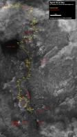
QUOTE (Shaka @ Apr 3 2006, 06:23 AM) I would be interested to see a highly detailed Spirit Route Map for the last two weeks. No, this isn't a "highly detailed" route map but just the usual one. Actually I haven't updated it since sol 787 simply because Spirit has been moving around the same point (for the resolution of this map). Sol 799 drive can be clearly seen on hazcam and navcam pics, but here on the map it's difficult to isolate from 782 and 787. Anyway, I thought it was just time to update it.
Edited: Wrong map! See post #389 right below. |
|
|
|
|
|
|
Apr 3 2006, 06:22 PM
Post
#387
|
|
|
Senior Member Group: Members Posts: 1229 Joined: 24-December 05 From: The blue one in between the yellow and red ones. Member No.: 618 |
Thanks, Tesh. Of course as soon as I express worry about Spirit's immobility, the next pictures show it successfully backed out of the quagmire, Deo gratias. I should do it sooner. Now we will see the new travel direction and strategy. Hopefully time remains for a successful escape.
-------------------- My Grandpa goes to Mars every day and all I get are these lousy T-shirts!
|
|
|
|
|
Apr 4 2006, 04:42 AM
Post
#388
|
|
|
Member Group: Members Posts: 530 Joined: 21-March 06 From: Canada Member No.: 721 |
QUOTE (Shaka @ Apr 3 2006, 12:22 PM) Thanks, Tesh. Of course as soon as I express worry about Spirit's immobility, the next pictures show it successfully backed out of the quagmire Sure, like you suggested, they put it in reverse and gunned it.  Brian |
|
|
|
|
Apr 5 2006, 09:19 AM
Post
#389
|
||
|
Senior Member Group: Moderator Posts: 4279 Joined: 19-April 05 From: .br at .es Member No.: 253 |
This is a correction to the sol 799 route map posted three entries above.
The current site isn't between sols 782 and 787 positions but between 781 and 782.
|
|
|
|
|
|
|
Apr 6 2006, 01:14 AM
Post
#390
|
||
|
Solar System Cartographer Group: Members Posts: 10157 Joined: 5-April 05 From: Canada Member No.: 227 |
Spirit route map. greatly reduced. I don't have good control for the last few positions yet. Because this is a composite of separate maps there are places where the join is bad. I'll fix it later. The relief distortions are worse here than for Opportunity. Don't take it as gospel.
Phil
-------------------- ... because the Solar System ain't gonna map itself.
Also to be found posting similar content on https://mastodon.social/@PhilStooke Maps for download (free PD: https://upload.wikimedia.org/wikipedia/comm...Cartography.pdf NOTE: everything created by me which I post on UMSF is considered to be in the public domain (NOT CC, public domain) |
|
|
|
|
|
|

|
Lo-Fi Version | Time is now: 4th May 2024 - 02:00 AM |
|
RULES AND GUIDELINES Please read the Forum Rules and Guidelines before posting. IMAGE COPYRIGHT |
OPINIONS AND MODERATION Opinions expressed on UnmannedSpaceflight.com are those of the individual posters and do not necessarily reflect the opinions of UnmannedSpaceflight.com or The Planetary Society. The all-volunteer UnmannedSpaceflight.com moderation team is wholly independent of The Planetary Society. The Planetary Society has no influence over decisions made by the UnmannedSpaceflight.com moderators. |
SUPPORT THE FORUM Unmannedspaceflight.com is funded by the Planetary Society. Please consider supporting our work and many other projects by donating to the Society or becoming a member. |
|