Geomorphology of Cape York and Solander Point, Examining Opportunity's destination at Endeavour Crater |

  |
Geomorphology of Cape York and Solander Point, Examining Opportunity's destination at Endeavour Crater |
 Jul 9 2010, 02:24 AM Jul 9 2010, 02:24 AM
Post
#31
|
|
|
Senior Member  Group: Members Posts: 1043 Joined: 17-February 09 Member No.: 4605 |
Trying to confirm a shoreline after a few billion years of erosion is a bit of an ask. What I do find interesting is that Cape York and immediate surrounds have phyllosilicates which would seem to indicate a long lasting, non acidic water influence. in the deeper areas around Cape York are the typical Meridiani sulphates indicating a second sedimentary deposition. In this scenario equating phyllosolicates to permanent surface standing water is really seductive.
|
 |
 
|
|
Jul 9 2010, 06:03 AM
Post
#32
|
|
|
Member Group: Members Posts: 184 Joined: 2-March 06 Member No.: 692 |
Just to toss in my 2 cents worth, when I look at cape york from above, I see the black hills of south dakota. They're a bit of old eroded mountain range complete with a "race track" of the spearfish formation forming a perifery around it. It's what a billion years of differential erosion will do. I know this is a crater rim but the same processes would apply. Any assymetries could be due to wind differences or the way the original crater rim was blasted out.
That cleft at the top is really interesting though!! |
|
|
|
|
Jul 9 2010, 08:45 AM
Post
#33
|
|
|
Senior Member Group: Members Posts: 3516 Joined: 4-November 05 From: North Wales Member No.: 542 |
QUOTE (algorimancer @ Jul 8 2010, 06:26 PM)  beach geology I was using the word 'beach' in a very lazy way as shorthand for 'shoreline feature'. I realise that in a geomorphology thread that's inappropriate and I apologise for the sloppiness. What we may call the Cape York terrace (though it can actually be traced around much of the Endeavour rim) has to be a hard formation to have resisted erosion in the way it apparently has. The result of some sort of concretion process happening at the lake margin maybe, rather than loose material emplaced by wave action. Another possibility is that it marks the stable stand of an old water table from a time when the whole of Endeavour was filled with porous sediments. I also have been looking for signs of an outflow, but maybe in the wrong place. I thought the lowest gaps in the rim lay in the general direction of Iazu. There are some channel-like features there that appear to begin a short distance outside the crater and flow away from it. |
|
|
|
|
Jul 9 2010, 09:35 AM
Post
#34
|
|
|
Newbie Group: Members Posts: 15 Joined: 28-November 08 From: Germany Member No.: 4498 |
Judging from the DTM I used in post #30, the lake would start to spill through Torres Strait if the lake level were only about 10 - 15 m higher. But the valley winding around Cape Tribulation appears to be lower.
Regarding the billions of years of erosion, I remember that the erosion rates for the last 2.5 billion years are thought to be extremely low (can´t find that paper right now). Let me throw in two observations from my area: First, the South German Molasse Basin has a c. 15 million years old shoreline that is still, in places, a quite well-preserved terrace-like feature. And erosion rates are definitly higher than on Mars! I will look for numbers if you are interested. Second, since this is a crater rim, I´m not convinced that the rocks of Cape York formed at its present place. The Ries crater in Bavaria (24 km) is known to have ejected relatively intact blocks up to 1.5 km in size. If Cape York were such a block, its rocks could have formed at a much deeper topographic level, and before the Endeavour cratering event. So, the phyllosilicates may have formed much earlier, and could be totally unrelated to the hypothetical younger shoreline. |
|
|
|
|
Jul 9 2010, 11:00 AM
Post
#35
|
|
|
Senior Member Group: Members Posts: 3516 Joined: 4-November 05 From: North Wales Member No.: 542 |
Time for me to take another look at the Tribulation channel, viewing it as a possible exit. (In my mind's eye I had it flowing the other way.) Follow this link for Nirgal's 3D views of that location:
http://www.unmannedspaceflight.com/index.p...st&p=156417 |
|
|
|
|
Jul 13 2010, 07:01 AM
Post
#36
|
|
|
Member Group: Members Posts: 146 Joined: 31-October 08 Member No.: 4473 |
I have my doubts about wave erosion and shores, at least of a free liquid water surface during the briny times Endeavour was formed. I think Mars was too cold by then, any body of water would be mostly ice-covered. I do think that an ice-layer (maybe thin) over brine is worth considering. There could be a situation with the Martian atmosphere below the water triple point, but wet brine would exist under ice bound to the soil. If the brine started to pool, it would then evaporate, but the soil would stay wet, but no (or few) actual liquid pools. This wetness could mobilize the overlying ice layer if on or near a slope, and a little erosion could occur (remember the ramps and headlands of Victoria?). The rim of Endeavour has a different composition and is above the local water table, so it would have a different history. And any soil water would not have the same brine content. It would erode/be-overlain differently.
Remember also that Meridiani is not like many other areas of Mars, no other area of extensive Hematite anywhere near its size exists on Mars (there are a smattering of smaller areas). So its history is not the same as the ancient northern ocean. |
|
|
|
|
Feb 9 2011, 10:59 AM
Post
#37
|
|||
 Senior Member Group: Members Posts: 1079 Joined: 19-February 05 From: Close to Meudon Observatory in France Member No.: 172 |
Stu, your mosaic is great !
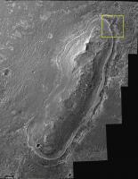
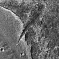
Thanks to it, I realized that one of the most interesting geological features to be seen on Cape York is "Dagger Valley" (outlined in yellow, a name I'm humbly suggesting) : a big incision with many layers surely to be sampled, like inside a small canyon. It exploration would complement our understanding of the history of past climate on Mars, as well as of Cape York itself... 
|
||
|
|
|
||
|
Feb 9 2011, 11:46 AM
Post
#38
|
|
|
Senior Member Group: Members Posts: 3516 Joined: 4-November 05 From: North Wales Member No.: 542 |
Just a reminder - link back to Nirgal's 3D featuring Dagger Valley: http://www.thethirdplanet.de/mars_gallery/...5/page-0004.htm
|
|
|
|
|
Feb 9 2011, 01:16 PM
Post
#39
|
|
 Senior Member Group: Members Posts: 2173 Joined: 28-December 04 From: Florida, USA Member No.: 132 |
QUOTE (vikingmars @ Feb 9 2011, 05:59 AM) ..."Dagger Valley" ...a big incision with many layers surely to be sampled, like inside a small canyon.... That certainly is an interesting feature. How it might have been formed, I have no clue. I'm not sure about the "layers" part though. If Cape York is part of Endeavour's rim, whatever layers may have existed before the impact are probably quite jumbled. I'm no crater rim morphology expert though.Then there's that "freshish" crater on the South end, with plenty of large ejecta blocks scattered about. Those are not likely to be blocks of the same Meridiani pavement that Opportunity has been traversing for years, but blocks of whatever yet unexamined material the ancient rim of Endeavour is made of. I'd like to see those up close! What a conundrum! The two most interesting features of Cape York are on the two extreme ends. I wonder if in the final approach, Opportunity will be directed to either end of Cape York or if the "landing" will take place near the center as previously indicated. |
|
|
|
|
Feb 9 2011, 04:08 PM
Post
#40
|
|
|
Senior Member Group: Members Posts: 1580 Joined: 14-October 05 From: Vermont Member No.: 530 |
QUOTE (centsworth_II @ Feb 9 2011, 09:16 AM) Then there's that "freshish" crater on the South end, with plenty of large ejecta blocks scattered about. Caught my eye, too. If there's no accessible emplaced outcrop not buried in dust and rubble, that will be a likely place to look for some good rocks. |
|
|
|
|
Feb 9 2011, 04:56 PM
Post
#41
|
|
|
Member Group: Members Posts: 146 Joined: 31-October 08 Member No.: 4473 |
The "shore-like" features around Cape York are most likely the result of a combination of evaporite deposit-cementation and ice erosion. [IMHO].
It seems likely to me that any Martian body of water would be ice-covered nearly all the time, so any "shoreline" erosion features would be dominated by this layer of ice. Indeed, glacial patterns may dominate. Probably some sort of snow/brine freeze-thaw/dust cycle. Terrestrial analogs? |
|
|
|
|
Feb 9 2011, 09:08 PM
Post
#42
|
|
|
Member Group: Members Posts: 194 Joined: 3-January 10 Member No.: 5156 |
Just an intermediate hint (from Emily): There is a new paper, which covers all discoveries by Opportunity between sols 511 and 2300
http://www.agu.org/pubs/crossref/2011/2010JE003746.shtml Abstract: "Key new results include (1) atmospheric argon measurements that demonstrate the importance of atmospheric transport to and from the winter carbon dioxide polar ice caps; (2) observations showing that aeolian ripples covering the plains were generated by easterly winds during an epoch with enhanced Hadley cell circulation; (3) the discovery and characterization of cobbles and boulders that include iron and stony-iron meteorites and Martian impact ejecta; (4) measurements of wall rock strata within Erebus and Victoria craters that provide compelling evidence of formation by aeolian sand deposition, with local reworking within ephemeral lakes; (5) determination that the stratigraphy exposed in the walls of Victoria and Endurance craters show an enrichment of chlorine and depletion of magnesium and sulfur with increasing depth. This result implies that regional-scale aqueous alteration took place before formation of these craters" I am very interested in this paper, but it isn't public  Has somebody read it? -------------------- Need more input ...
|
|
|
|
|
Feb 10 2011, 04:21 AM
Post
#43
|
|
|
Senior Member Group: Members Posts: 1043 Joined: 17-February 09 Member No.: 4605 |
Try this link
http://www.gps.caltech.edu/~grotz/Publicat...e_Purgatory.pdf Edit: Sorry, wrong side of the ripple but may still be of interest. |
|
|
|
|
Feb 10 2011, 09:50 AM
Post
#44
|
|
|
Senior Member Group: Members Posts: 1079 Joined: 19-February 05 From: Close to Meudon Observatory in France Member No.: 172 |
QUOTE (centsworth_II @ Feb 9 2011, 02:16 PM) What a conundrum! The two most interesting features of Cape York are on the two extreme ends. I wonder if in the final approach, Opportunity will be directed to either end of Cape York or if the "landing" will take place near the center as previously indicated. Totally agree ! If they choose the southern feature, it will be more easy then to rove south and explore the other capes... So, with a geological point of view I would go north and explore Dagger Valley  With a Navigator's operational point of view, I would go south... 
|
|
|
|
|
Feb 10 2011, 04:31 PM
Post
#45
|
||
|
Junior Member Group: Members Posts: 59 Joined: 18-July 07 From: London, UK Member No.: 2873 |
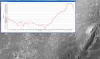
I've had a look at Cape York in my HiRISE DEM and I'm struggling to get much out of it topography-wise.
It looks like it's pretty low, ~6 m high (is that right?!), with something (albeit subtle) going on with those features around the edge. But to be honest, this area is really pushing the quality of my DEM: it's on a slope to the East, the MOLA shot points are scarce around here, and the surface texture is a bit dusty for pixel matching. So, combined with the vertical precision of my DEM being about 30 cm (I haven't checked), I'd only take this profile as a general guide. But it's still fun nonetheless! 3D views (with same health-warning) to follow. Pete |
|
|
|
|
|
|

|
Lo-Fi Version | Time is now: 16th April 2024 - 05:03 PM |
|
RULES AND GUIDELINES Please read the Forum Rules and Guidelines before posting. IMAGE COPYRIGHT |
OPINIONS AND MODERATION Opinions expressed on UnmannedSpaceflight.com are those of the individual posters and do not necessarily reflect the opinions of UnmannedSpaceflight.com or The Planetary Society. The all-volunteer UnmannedSpaceflight.com moderation team is wholly independent of The Planetary Society. The Planetary Society has no influence over decisions made by the UnmannedSpaceflight.com moderators. |
SUPPORT THE FORUM Unmannedspaceflight.com is funded by the Planetary Society. Please consider supporting our work and many other projects by donating to the Society or becoming a member. |
|