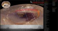
Endeavour Crater, And again shall we conquer the Remoteness |

  |
Endeavour Crater, And again shall we conquer the Remoteness |
 Jun 8 2009, 09:18 PM Jun 8 2009, 09:18 PM
Post
#286
|
|
|
Junior Member  Group: Members Posts: 87 Joined: 17-May 08 Member No.: 4114 |
Regarding DTMs, don't forget there's Mars HRSC coverage of this area too.
http://hrscview.fu-berlin.de/cgi-bin/ion-p...p;code=52692150 |
 |
 
|
|
Jun 22 2009, 08:54 PM
Post
#287
|
|
 Member Group: Members Posts: 813 Joined: 8-February 04 From: Arabia Terra Member No.: 12 |
This may have been asked before, but does anyone know whether MARSIS or SHARAD might be capable of mapping the contact between the Meridiani sandstones and the underlying basement rock?
|
|
|
|
|
Jun 23 2009, 02:32 AM
Post
#288
|
|
|
Member Group: Members Posts: 233 Joined: 21-April 05 Member No.: 328 |
Speaking of shorelines, I'm sure most of you know that there is yet another recent paper indicating the presence of lakes on Mars. Here's the link:
http://www.colorado.edu/news/r/7e9c22ec0cd...4ed2e29f16.html |
|
|
|
|
Jun 23 2009, 10:10 PM
Post
#289
|
|
|
Member Group: Senior Member Posts: 136 Joined: 8-August 06 Member No.: 1022 |
QUOTE (glennwsmith @ Jun 22 2009, 06:32 PM)  Speaking of shorelines, I'm sure most of you know that there is yet another recent paper indicating the presence of lakes on Mars. Here's the link: http://www.colorado.edu/news/r/7e9c22ec0cd...4ed2e29f16.html It's a fault scarp. (see my post in "Earthlike Mars") -Tim. |
|
|
|
|
Jun 27 2009, 09:27 PM
Post
#290
|
|
|
Member Group: Members Posts: 813 Joined: 8-February 04 From: Arabia Terra Member No.: 12 |
For fans of Iazu crater here's a Google Earth overlay of moc frame m1001349.
 Iazu_Crater__MOC_Image_m1001349_.kml ( 646bytes )
Number of downloads: 523
Iazu_Crater__MOC_Image_m1001349_.kml ( 646bytes )
Number of downloads: 523It's not sourced from a map projected version of the image so the registration isn't as great as it could be but when crudely draped over topography data it does give an OK overview of the differences between the older, shallower Endeavour and the younger pedestal crater to the south. Check out that deep stack of sediments at Iazu's north rim! Why not use a proper map projected version of the image? Because then I'd either have to put up with a conspicuous frame or set the frame to be transparent. Doing the latter would require altering the image file, so I would no longer be able to link to an image already available online! |
|
|
|
|
Jun 28 2009, 08:19 AM
Post
#291
|
|
|
Junior Member Group: Members Posts: 41 Joined: 27-May 09 From: Burgundy Member No.: 4798 |
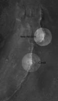
I think we can barely see a new part of Endeavour in these navcams just on the left of "Cook":
http://qt.exploratorium.edu/mars/opportuni...G6P1994L0M1.JPG http://qt.exploratorium.edu/mars/opportuni...NVP1994L0M1.JPG Waiting for pancams. I think a peak north of "Cook" could match (far rim  or east rim) . Any idea Rui or James ? or east rim) . Any idea Rui or James ?
|
|
|
|
|
Jun 28 2009, 01:39 PM
Post
#292
|
|
|
Member Group: Admin Posts: 976 Joined: 29-September 06 From: Pasadena, CA - USA Member No.: 1200 |
QUOTE (Bill @ Jun 28 2009, 12:19 AM) I think we can barely see a new part of Endeavour in these navcams just on the left of "Cook": ... P1994 is a single frame, single eye navcam frame I asked to take at the end of each drive since we left Duck Bay. Every drive sol in the same direction, roughly pointed at Endeavour. Paolo -------------------- Disclaimer: all opinions, ideas and information included here are my own,and should not be intended to represent opinion or policy of my employer.
|
|
|
|
|
Jun 28 2009, 02:53 PM
Post
#293
|
||
 Senior Member Group: Moderator Posts: 2262 Joined: 9-February 04 From: Melbourne - Oz Member No.: 16 |
QUOTE (Bill @ Jun 28 2009, 09:19 AM) I think a peak north of "Cook" could match (far rim or east rim) . Any idea Rui or James ?I think you are right, there does appear to be a faint hint of a feature 6 - 8 degrees from the north end of Cook. Measuring the angles I think it correlates to this on the HRSC image:
In Google Earth this does look to be the next highest feature on the east rim after Cook. James -------------------- |
|
|
|
|
|
|
Jun 28 2009, 09:21 PM
Post
#294
|
|
|
Senior Member Group: Moderator Posts: 4279 Joined: 19-April 05 From: .br at .es Member No.: 253 |
QUOTE (RoverDriver @ Jun 28 2009, 03:39 PM) P1994 is a single frame, single eye navcam frame I asked to take at the end of each drive since we left Duck Bay. Every drive sol in the same direction, roughly pointed at Endeavour. Paolo Got it! Now I understand the "MovieFrame" in the sequence name.  Anyone wants to have a try building the movie up to date? |
|
|
|
|
Jun 29 2009, 02:33 AM
Post
#295
|
|
 Senior Member Group: Members Posts: 4246 Joined: 17-January 05 Member No.: 152 |
I've been collecting these L0 navcam frames and was meaning to ask about them. Do they serve a purpose such as photometry/sky imaging/characterizing the terrain under uniform lighting/etc, or are they just providing a regular view of the approaching rim of endeavour?
Btw, the R0 navcam jpeg frames from the jpl site are always cleaner than the L0 frames. This R0 frame shows a similar view to those two L0 frames: http://marsrovers.jpl.nasa.gov/gallery/all...EZP0705R0M1.JPG I think there is a very subtle feature there. |
|
|
|
|
Jun 29 2009, 03:03 AM
Post
#296
|
|
|
Member Group: Admin Posts: 976 Joined: 29-September 06 From: Pasadena, CA - USA Member No.: 1200 |
QUOTE (fredk @ Jun 28 2009, 06:33 PM) ... Do they serve a purpose such as photometry/sky imaging/characterizing the terrain under uniform lighting/etc, or are they just providing a regular view of the approaching rim of endeavour? ... Nope, their sole goal is to document the approach to Endeavour. I'm sure someone can make scientific use of it, but the idea was just that, documentation of the approach. Paolo -------------------- Disclaimer: all opinions, ideas and information included here are my own,and should not be intended to represent opinion or policy of my employer.
|
|
|
|
|
Jun 29 2009, 02:06 PM
Post
#297
|
|
|
Forum Contributor Group: Members Posts: 1372 Joined: 8-February 04 From: North East Florida, USA. Member No.: 11 |
A very good idea Paolo. At what horizontal distance from the highest rim will the frame be filled from top to bottem on the Navcams ?
|
|
|
|
|
Jun 30 2009, 11:21 AM
Post
#298
|
||
 Special Cookie Group: Members Posts: 2168 Joined: 6-April 05 From: Sintra | Portugal Member No.: 228 |
QUOTE (jamescanvin @ Jun 28 2009, 03:53 PM) In Google Earth this does look to be the next highest feature on the east rim after Cook. James...everyone knows that's Molyneaux...
-------------------- "Ride, boldly ride," The shade replied, "If you seek for Eldorado!"
Edgar Alan Poe |
|
|
|
|
|
|
Jun 30 2009, 12:17 PM
Post
#299
|
|
|
Senior Member Group: Moderator Posts: 2262 Joined: 9-February 04 From: Melbourne - Oz Member No.: 16 |
QUOTE (ustrax @ Jun 30 2009, 12:21 PM) James...everyone knows that's Molyneaux... Heck, I can't keep up - here was me thinking it was Hicks... http://www.unmannedspaceflight.com/index.p...st&p=137625 James -------------------- |
|
|
|
|
Jun 30 2009, 01:04 PM
Post
#300
|
|
|
Special Cookie Group: Members Posts: 2168 Joined: 6-April 05 From: Sintra | Portugal Member No.: 228 |
QUOTE (jamescanvin @ Jun 30 2009, 01:17 PM) Heck, I can't keep up - here was me thinking it was Hicks... Hicks is where Cook tells him to be... -------------------- "Ride, boldly ride," The shade replied, "If you seek for Eldorado!"
Edgar Alan Poe |
|
|
|
|

|
Lo-Fi Version | Time is now: 16th April 2024 - 08:29 AM |
|
RULES AND GUIDELINES Please read the Forum Rules and Guidelines before posting. IMAGE COPYRIGHT |
OPINIONS AND MODERATION Opinions expressed on UnmannedSpaceflight.com are those of the individual posters and do not necessarily reflect the opinions of UnmannedSpaceflight.com or The Planetary Society. The all-volunteer UnmannedSpaceflight.com moderation team is wholly independent of The Planetary Society. The Planetary Society has no influence over decisions made by the UnmannedSpaceflight.com moderators. |
SUPPORT THE FORUM Unmannedspaceflight.com is funded by the Planetary Society. Please consider supporting our work and many other projects by donating to the Society or becoming a member. |
|