Printable Version of Topic
Click here to view this topic in its original format
Unmanned Spaceflight.com _ Jupiter _ Shifted maps of Io
Posted by: Antdoghalo Jun 2 2015, 08:58 AM
Hello I have recently been doing a project where I find high resolution maps of a planet and put it into Google Earth. Then along with kml files found here http://planetarynames.wr.usgs.gov/GIS_Downloads I make a big overlay with it and upload it into Google Earth Community. Along the way I give credit to the makers of the images and map overlays.
The problem is I have ran into issues with Jupiter's moon Io. I cannot find high resolution maps without labels of Io that are centered on 0E (Pele on the right). While searching for maps I remembered that some on UMSF are planetary map enthusiasts and I was wondering if you please could help me find one or make one. I have tried the maps from astropedia but the ones for Io are too big in order for Google Earth to cooperate. The reason I want them to be centered on 0E with Pele on the right is because the nomenclature kml from USGS has the places located to fit into this configuration and it would take a really long time to do it otherwise.
I am looking for a map in the vicinity of between 8192 x 4096 and 4000 x 2000
Along with that a way to properly credit the author.
I don't know if this is exactly place in the forum to put this post, it's been a while 5 year since I was last here when I was a lot younger.
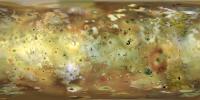
Posted by: Phil Stooke Jun 2 2015, 02:16 PM
So, is this map:
http://laps.noaa.gov/albers/sos/jupiter/io/io_rgb_cyl.jpg
OK except that you want a different central meridian?
(also, do you use Photoshop?)
Phil
Posted by: Antdoghalo Jun 2 2015, 10:19 PM
Yes please, I want a version that is rotated 180 degrees so that Pele and Loki are to the right of the meridian.
I don't use photoshop and I have nonexistant knowledge of how to use illustrator.
Posted by: Phil Stooke Jun 2 2015, 10:57 PM
Ok, on the assumptions that Steve won't object since his map is public anyway, and also that others might find it useful as well, here is Steve Albers' map of Io shifted 180 degrees.
Phil
|
Posted by: Antdoghalo Jun 2 2015, 11:45 PM
Thank you so much! It goes perfectly with the kml file on the USGS site!
By the way is there a way to properly credit Albers? I plan to share the overlay on Google Earth Community (a site for Google Earth hobbyists).
Posted by: scalbers Jun 3 2015, 06:22 PM
Greetings - glad you all have come across my Io map. I have a description of how this was constructed on my web site here:
http://laps.noaa.gov/albers/sos/sos.html#IO
Perhaps you can credit it to me (Steve Albers) and include this link. If you want to add some of that information, it's fine. It's funny that I never had figured out the identity of "Laika".
Posted by: JohnVV Jun 3 2015, 09:00 PM
i have a 8192x4096 map
----- 90n
-180 to 0 to +180
----- 90S
that is in my Celestia VT add on
a copy of it is also on my G-drive
https://drive.google.com/file/d/0B6ZYAd08tZL-RUptRFBGNGd3bW8/view?usp=sharing
a 1/4 2048x1024 preview
http://imgbox.com/Al78UnHf
this map is heavily cleaned up to remove seams and inpainted a few bad areas in the poles
Posted by: Antdoghalo Jun 4 2015, 12:56 AM
When I was finding maps for Venus on Astropedia I had a 50% success rate of the 6 jpeg maps they had of that size to work with GE. 3 worked and 3 didn't. I am not sure if png will work, I don't think it will.
Posted by: JohnVV Jun 5 2015, 06:59 AM
you can always use the terminal version of Gmic or imagemagick to convert it into any of the hundreds of formats they support
do you need a isis cub with latitude and longitude information ?
or
a GEO-Tiff with latitude and longitude information in a xml file ?
Posted by: Antdoghalo Jun 5 2015, 12:27 PM
Thanks however I was looking for a file online, then I would link it as an overlay to GE. If it was linked to a file on my computer it wouldn't show when I upload it Google Earth Community. I know very little of advanced image processing programs.
There is also a geological map of Io that I would like to have rotated as well as the white area on the outside removed (or it would not show properly).
http://upload.wikimedia.org/wikipedia/commons/a/a5/First_Geologic_Map_of_Jupiter%E2%80%99s_Moon_Io.jpg
Posted by: scalbers Jun 5 2015, 06:35 PM
Greetings - some of these aspects of using ImageMagick (that I like to use) and related tools might be discussed in this sub-forum:
http://www.unmannedspaceflight.com/index.php?showforum=57
We might also talk there about simple ways to post image files online?
Posted by: Antdoghalo Jun 6 2015, 01:05 AM
Thanks! I forgot there was a section dedicated to those and image conversion programs.
I will be able to post it on Photobucket.
Posted by: scalbers Jun 6 2015, 07:51 PM
For completeness I can mention this USGS map that was made after mine was. It is 11400 pixels wide:
http://astrogeology.usgs.gov/search/details/Io/Voyager-Galileo/Io_GalileoSSI-Voyager_Global_Mosaic_ClrMerge_1km/cub
It's been a while since I've worked with this large version, but it is a good map.
Posted by: Antdoghalo Jun 7 2015, 04:23 AM
That was the one I tried to use but I encountered problems with in Google Earth. It was able to load some of it but 3/4s of the image won't load because of GE's limitations at around 8192 pixels.
Posted by: Antdoghalo Jun 16 2015, 07:54 PM
I have completed the Jovian system overlay in Google Earth I was working on, you can find images of it here.
http://googleearthcommunity.proboards.com/thread/1260/jupiter-moons-megaoverlay
Unfortunately you currently need an account there to download it.
Again thanks for all the help, I couldn't have done it without you all.
Powered by Invision Power Board (http://www.invisionboard.com)
© Invision Power Services (http://www.invisionpower.com)