The Top of Vera Rubin Ridge Part 1, Site 66-67, sol 1812-1943, 11 Sep 2017-23 Jan 2018 |

  |
The Top of Vera Rubin Ridge Part 1, Site 66-67, sol 1812-1943, 11 Sep 2017-23 Jan 2018 |
 Jan 16 2018, 10:16 AM Jan 16 2018, 10:16 AM
Post
#316
|
||
 Member  Group: Members Posts: 112 Joined: 20-August 12 From: Spain Member No.: 6597 |
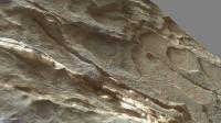
Hope this angle clarifies better than it is a groove, and not a ridge

|
|
 |
 
|
|
|
Jan 16 2018, 06:53 PM
Post
#317
|
|
|
Member Group: Members Posts: 866 Joined: 15-March 05 From: Santa Cruz, CA Member No.: 196 |
one optical illusion down, and the tricks continue on sol1934: now you see it and now you dont, time for a treasure hunt!
|
|
|
|
|
Jan 16 2018, 07:09 PM
Post
#318
|
||
 Member Group: Members Posts: 334 Joined: 11-December 12 From: The home of Corby Crater (Corby-England) Member No.: 6783 |
I found Wally!!!!
See bottom of this image.
|
|
|
|
|
|
|
Jan 16 2018, 08:51 PM
Post
#319
|
|
|
Solar System Cartographer Group: Members Posts: 10146 Joined: 5-April 05 From: Canada Member No.: 227 |
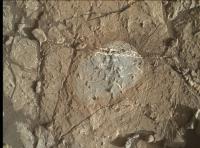
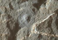
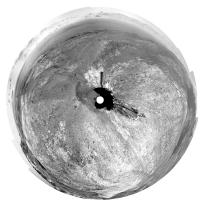
In this image:
http://www.midnightplanets.com/web/MSL/ima...53C00_DXXX.html there is a central pit surrounded by a circular groove. The cast shadows show light is coming from the right side. The pit is made by that central pin, which this time pressed down hard enough to make a mark in soft rock. The circular groove is made by a small off-centre clump of protruding bristles, like last time. A mark made by the central pin has been seen before, and sometimes people have misinterpreted it as made by the clump of bristles, but they are off-centre and will not make such a small mark. Phil -------------------- ... because the Solar System ain't gonna map itself.
Also to be found posting similar content on https://mastodon.social/@PhilStooke NOTE: everything created by me which I post on UMSF is considered to be in the public domain (NOT CC, public domain) |
|
|
|
|
Jan 16 2018, 09:46 PM
Post
#320
|
|
|
Member Group: Members Posts: 866 Joined: 15-March 05 From: Santa Cruz, CA Member No.: 196 |
small off-center clump of twisted-up bristles sol1931 and the side view, so wow that circular groove sol1933 really is correspondingly tiny, i'm always overestimating the size of these images, the circle is not several cm, but mm across. i was interpreting the twisted clump to be caused by the brush hitting up against the lip next to the circle but it seems to have been there sols earlier.
|
|
|
|
|
Jan 17 2018, 07:49 AM
Post
#321
|
|
 Senior Member Group: Members Posts: 2425 Joined: 30-January 13 From: Penang, Malaysia. Member No.: 6853 |
QUOTE (atomoid @ Jan 17 2018, 05:46 AM)  ...i'm always overestimating the size of these images, the circle is not several cm, but mm across. Good call... Using Gerald's MAHLI ruler on the pre-merged image from sol 1931 with a focus count of 13979 shows the groove diameter to be just 3mm. If I had checked that first I would probably have not called it a sandy deposit from the APXS
|
|
|
|
|
Jan 17 2018, 09:07 AM
Post
#322
|
|
|
Senior Member Group: Members Posts: 1043 Joined: 17-February 09 Member No.: 4605 |
The dust removal tool brushes are articulated in the vertical axis to maintain constant contact with the surface, rotating at high speed and covering a circular area of 45mm diameter. I guess that age has indeed wearied me and the years condemned because I cannot understand how this operating profile can produce such a small, 3mm circular groove. Obviously it did but how, given that the offset clump of bristles cannot rotate independently?
|
|
|
|
|
Jan 17 2018, 01:34 PM
Post
#323
|
|
|
Senior Member Group: Members Posts: 2346 Joined: 7-December 12 Member No.: 6780 |
Consider the bristles as compasses. They'll create approximately concentrical circles on the target. Non-concentrical circles are obtained easiest by displacing the DRT perpendicular to its spin axis.
|
|
|
|
|
Jan 17 2018, 10:52 PM
Post
#324
|
|
|
Senior Member Group: Members Posts: 1043 Joined: 17-February 09 Member No.: 4605 |
Indeed, 45mm diameter concentric circles. But the brushes do not rotate independently so the question as to how the 3mm diameter circular groove formed stands. We have not seen this phenomena before and although I anticipate that when explained it will be a doh moment, at present it is an itch that I cannot seem to scratch.
|
|
|
|
|
Jan 17 2018, 11:45 PM
Post
#325
|
|
|
Solar System Cartographer Group: Members Posts: 10146 Joined: 5-April 05 From: Canada Member No.: 227 |
Here's one, not so well developed, from sol 1744:
http://www.midnightplanets.com/web/MSL/ima...66C00_DXXX.html The bunch of bristles changes shape over time - someone might like to make a comparison, I don't have time right now. So the resulting mark will change as well - and will also depend on the hardness of the rock. Early in the mission there was no bunch of protruding bristles, and for a long time the rocks were harder. This must be fairly soft, maybe the clay they expect south of the ridge - and here we are right on the south edge of the ridge. -------------------- ... because the Solar System ain't gonna map itself.
Also to be found posting similar content on https://mastodon.social/@PhilStooke NOTE: everything created by me which I post on UMSF is considered to be in the public domain (NOT CC, public domain) |
|
|
|
|
Jan 18 2018, 02:18 AM
Post
#326
|
||
|
Senior Member Group: Members Posts: 1043 Joined: 17-February 09 Member No.: 4605 |
Actually Phil's identification of the central pin indentation may hold the answer as the bristles seem to scribe a groove around the pin on occasion.
As Phil and also MrNatural identify, this is comparatively soft rock compared to the hematite ridge which could reflect lack of consolidation as well as cementing agent. If it is clay then would this tend to imply that it was formed after the Mount Sharp overburden had eroded away?
Attached thumbnail(s)
|
|
|
|
|
|
|
Jan 18 2018, 02:59 AM
Post
#327
|
|
|
Junior Member Group: Members Posts: 42 Joined: 19-October 12 Member No.: 6719 |
QUOTE (serpens @ Jan 18 2018, 02:18 AM) Actually Phil's identification of the central pin indentation may hold the answer as the bristles seem to scribe a groove around the pin on occasion. As Phil and also MrNatural identify, this is comparatively soft rock compared to the hematite ridge which could reflect lack of consolidation as well as cementing agent. If it is clay then would this tend to imply that it was formed after the Mount Sharp overburden had eroded away? Not sure if MSL has reached the Clay Unit, but given the softness of this rock and its visual appearance, I would think that this would be a good place to try the new drilling strategy. I suspect that ever since MSL landed, the team has wanted to analyze the Clay Unit with SAM, even if MSL has run into clay at many other drill sites (but these clay's were not visible with CRISM). |
|
|
|
|
Jan 19 2018, 01:17 PM
Post
#328
|
||
|
Senior Member Group: Members Posts: 2425 Joined: 30-January 13 From: Penang, Malaysia. Member No.: 6853 |
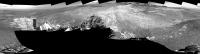
Quick and dirty, 1939 bump using MS-ICE with the R-NavCam's (Mods can delete post after a better version is posted) Hopefully it will assist in firming up the location
|
|
|
|
|
|
|
Jan 19 2018, 11:32 PM
Post
#329
|
||
|
Solar System Cartographer Group: Members Posts: 10146 Joined: 5-April 05 From: Canada Member No.: 227 |
Paul's panorama in circular form.
Phil
-------------------- ... because the Solar System ain't gonna map itself.
Also to be found posting similar content on https://mastodon.social/@PhilStooke NOTE: everything created by me which I post on UMSF is considered to be in the public domain (NOT CC, public domain) |
|
|
|
|
|
|
Jan 19 2018, 11:56 PM
Post
#330
|
|
 Senior Member Group: Members Posts: 1619 Joined: 12-February 06 From: Bergerac - FR Member No.: 678 |
So ! I've been working since weeks on a project of my own : a full color panoramic mixing Mastcam and Navcam imagery from Sol 1903. It was harsh, made on a 10 year old computer, but I had to do it.
Check it out : 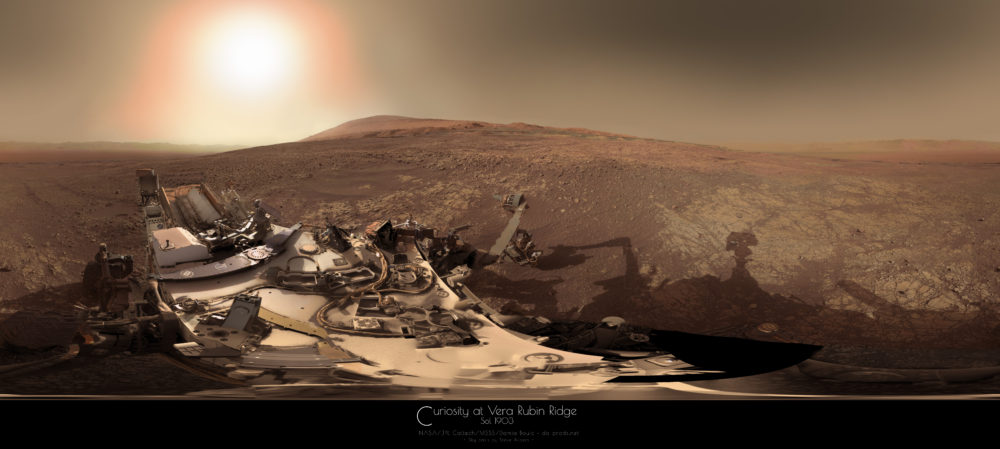 And thank you for one of your martian sky modelisation scalbers (but I had to modify it in order to have good merges)
-------------------- |
|
|
|
|

|
Lo-Fi Version | Time is now: 19th April 2024 - 01:11 AM |
|
RULES AND GUIDELINES Please read the Forum Rules and Guidelines before posting. IMAGE COPYRIGHT |
OPINIONS AND MODERATION Opinions expressed on UnmannedSpaceflight.com are those of the individual posters and do not necessarily reflect the opinions of UnmannedSpaceflight.com or The Planetary Society. The all-volunteer UnmannedSpaceflight.com moderation team is wholly independent of The Planetary Society. The Planetary Society has no influence over decisions made by the UnmannedSpaceflight.com moderators. |
SUPPORT THE FORUM Unmannedspaceflight.com is funded by the Planetary Society. Please consider supporting our work and many other projects by donating to the Society or becoming a member. |
|