Whole Earth images, Does any satellite provide regularly updated ones? |

  |
Whole Earth images, Does any satellite provide regularly updated ones? |
 Jul 6 2008, 08:51 PM Jul 6 2008, 08:51 PM
Post
#91
|
||
 Senior Member  Group: Moderator Posts: 2785 Joined: 10-November 06 From: Pasadena, CA Member No.: 1345 |
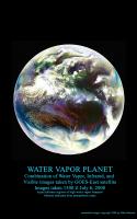
Combination of Water Vapor (primarily), Infrared, and Visible images from the GOES-East geostationary satellite. These images were downloaded from the Dundee Receiving Station website today (images for July 6, 20081500 UTC)
Aqua and blue tones indicates higher levels of water vapor, while maroon tones indicate drier air. In the central Atlantic, Tropical Storm Bertha can be seen leaving a trail of clouds to the east as it pumps water vapor into the atmosphere. -Mike -------------------- Some higher resolution images available at my photostream: http://www.flickr.com/photos/31678681@N07/
|
|
 |
 
|
|
|
Jul 6 2008, 08:58 PM
Post
#92
|
|
 Senior Member Group: Members Posts: 3648 Joined: 1-October 05 From: Croatia Member No.: 523 |
Ooh... funky stuff!
-------------------- |
|
|
|
|
Aug 3 2008, 01:02 AM
Post
#93
|
|
|
Member Group: Members Posts: 194 Joined: 8-February 04 Member No.: 10 |
Thanks to Robert Beal of the John Hopkins Applied Physics Lab, I now have on my site a copy of the first color image of the Earth as a disk. It was made September 20, 1967 by the Department Of Defense Gravity Experiment satellite (DODGE). He worked on the mission, painting the spherical color target at the end of the boom and photographically assembling the color image. Beal sent me a file based on a print he made, which he had color balanced to resemble the ATS Earth image on my site. Upon my request he reconstructed the color scheme of the poorly imaged target from memory. I was told the colors used, similar in philosophy to Surveyor, were radiation resistant paints which happened to be of low saturation. The idea of a spherical color target is interesting, and strikes me as ingenious. If both target and background are sunlit the target can supply useful information at a wide range of lighting angles. Has this method been used in other camera carrying spacecraft?
In a separate version I have repainted the color target, fixing the motion blur in the boom in the blue channel, and tried to 'fine tune' the Autochrome like image into a kind of 'reconstruction' of how it might have appeared if all imaging steps worked ideally. http://www.donaldedavis.com/2003NEW/NEWSTUFF/DDEARTH.html Don |
|
|
|
|
Aug 3 2008, 07:13 AM
Post
#94
|
|
 The Poet Dude Group: Moderator Posts: 5551 Joined: 15-March 04 From: Kendal, Cumbria, UK Member No.: 60 |
That's quite a coup you have there, well done. I had no idea images like that were being taken so early on. Thanks for sharing it with us here.

-------------------- |
|
|
|
|
Aug 4 2008, 03:50 PM
Post
#95
|
|
 Member Group: Members Posts: 198 Joined: 2-March 05 From: Richmond, VA USA Member No.: 181 |
QUOTE (ugordan @ Feb 5 2008, 12:19 PM)  Rogelio, I can't tell if those are forest fires or not. The official image advisory doesn't mention them, but I've found a site concerned with forest fires which claims the 2005 year was particularly bad in terms of fires in the Amazon (something about reduced rainfall that season). It does look like smoke, but then again, it could be low haze due to air humidity in the region. It's widespread all the way to the Andes so I'm inclined to say that's indeed smoke. I can't find any GOES-East satellite archive going back to August 2005 to better see what that was. A bit late but hopefully still helpful.... http://www.ncdc.noaa.gov/gibbs/image/GOE-12/VS/2005-08-02-15 |
|
|
|
|
Aug 21 2008, 02:51 AM
Post
#96
|
||
|
Senior Member Group: Moderator Posts: 2785 Joined: 10-November 06 From: Pasadena, CA Member No.: 1345 |
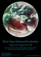
Animated loop of the Atlantic Basin of the Earth from August 10-20, 2008 in Amazing AquaVision (click to launch 1 Mb animated GIF):
Tropical Storm Fay (AKA "The Joker") can be seen pulsing her way into the Florida peninsula. -Mike (I gotta figure how to host the big version somewhere...) -------------------- Some higher resolution images available at my photostream: http://www.flickr.com/photos/31678681@N07/
|
|
|
|
|
|
| Guest_PhilCo126_* |
Aug 21 2008, 06:19 PM
Post
#97
|
|
Guests |
Nice picture, ugordan, Moon orientation a bit too close to Earth... otherwise no remarks

|
|
|
|
|
Aug 21 2008, 07:28 PM
Post
#98
|
|
 Director of Galilean Photography Group: Members Posts: 896 Joined: 15-July 04 From: Austin, TX Member No.: 93 |
Juramike,
The best places for weather discussion I've found is Weather Underground, www.weatherunderground.com. Check out their blogs. -------------------- Space Enthusiast Richard Hendricks
-- "The engineers, as usual, made a tremendous fuss. Again as usual, they did the job in half the time they had dismissed as being absolutely impossible." --Rescue Party, Arthur C Clarke Mother Nature is the final inspector of all quality. |
|
|
|
|
Aug 21 2008, 10:24 PM
Post
#99
|
|
|
Senior Member Group: Moderator Posts: 2785 Joined: 10-November 06 From: Pasadena, CA Member No.: 1345 |
Weather Underground is a great site. I'm a huge fan of the Tropical blog.
The water vapor images of the Earth make our own planet seem so...alien. The overall beltlike appearance in the Water Vapor images of moist zones and dry zones make Earth look much more like Venus (with Earth just having a few more nodes). The things that really piqued my interest in the (tiny) loop above are the clear zones that seems to be forming around and beyond developing warm core tropical systems like Tropical Storm Fay and Invest 94. These dark, dryish surrounding zones seem to actually "push and clear" into the ITCZ. I've just spent a few hours prowling on the web trying to figure what makes these clear zones in the Water Vapor loop (without much luck). The smaller swirls at the edge of Saturn's South Polar Vortex (multispectral imaging in PIA08333) look kinda similar, as if the isolated eddies are "pushing and clearing" into surrounding belts. Are they formed by the same mechanism or totally different? Who knows? It's fascinating how overall similar the structures are. Even the swirling loops around Antarctica look like Earth has it's own South Polar Vortex - just with a more fluid and changing boundary. -Mike -------------------- Some higher resolution images available at my photostream: http://www.flickr.com/photos/31678681@N07/
|
|
|
|
|
Sep 15 2008, 07:33 AM
Post
#100
|
|
 Senior Member Group: Moderator Posts: 2262 Joined: 9-February 04 From: Melbourne - Oz Member No.: 16 |
Images of storms are rather off topic for this thread, i've moved them to a new one:
Storms from Orbit -------------------- |
|
|
|
|
Jul 23 2009, 03:16 PM
Post
#101
|
||||
|
Senior Member Group: Moderator Posts: 2785 Joined: 10-November 06 From: Pasadena, CA Member No.: 1345 |
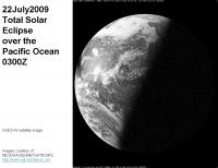
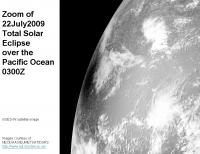
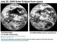
Geostationary satellites caught the 22July2009 Eclipse!
Here's a striking shot over the Pacific Ocean from the GOES-W satellite at 0300 UTC:
Hi-res zoom of same region:
And here is an image from MTSAT over Asia, comparison with the day before image shows where the shadow is:
NASA's Earth Observatory has color images taken at 8:30 AM and 9:30 AM Tiawan local time. (0300 Z = 11 AM Tiawan time?): http://earthobservatory.nasa.gov/IOTD/view.php?id=39520 -Mike -------------------- Some higher resolution images available at my photostream: http://www.flickr.com/photos/31678681@N07/
|
|||
|
|
|
|||
|
Jul 24 2009, 01:56 PM
Post
#102
|
|
 Senior Member Group: Members Posts: 1465 Joined: 9-February 04 From: Columbus OH USA Member No.: 13 |
This may be 180° off-topic, but are any photographic (or pseudo-photographic) "whole sky" images available? Showing, say, the visible night sky from Earth on a cylindrical projection?
-------------------- |
|
|
|
|
Jul 24 2009, 02:59 PM
Post
#103
|
|
 Senior Member Group: Members Posts: 1421 Joined: 26-July 08 Member No.: 4270 |
QUOTE (Juramike @ Jul 23 2009, 09:16 AM) Geostationary satellites caught the 22July2009 Eclipse! I don't know much about this... but shouldn't the geostationary satellites catch a solar eclipse every time? -------------------- -- Hungry4info (Sirius_Alpha)
|
|
|
|
|
Jul 24 2009, 03:04 PM
Post
#104
|
|
|
Founder Group: Chairman Posts: 14432 Joined: 8-February 04 Member No.: 1 |
They do.
|
|
|
|
|
Jul 24 2009, 05:15 PM
Post
#105
|
|
 Senior Member Group: Members Posts: 1281 Joined: 18-December 04 From: San Diego, CA Member No.: 124 |
I am confused - a geostationary orbit is fixed over a point of the earth - wouldn't that mean that they would only see an eclipse in the hemisphere they can see?
Would this little guy (which appears to have a new chance at launching) have a better view of the only sunlit side and thus all eclipses? Or would a satellite at the Earth-Sun L1 just see the transit of the moon across the earth's sunlit face rather than it's shadow? -------------------- Lyford Rome
"Zis is not nuts, zis is super-nuts!" Mathematician Richard Courant on viewing an Orion test |
|
|
|
|

|
Lo-Fi Version | Time is now: 27th April 2024 - 03:10 PM |
|
RULES AND GUIDELINES Please read the Forum Rules and Guidelines before posting. IMAGE COPYRIGHT |
OPINIONS AND MODERATION Opinions expressed on UnmannedSpaceflight.com are those of the individual posters and do not necessarily reflect the opinions of UnmannedSpaceflight.com or The Planetary Society. The all-volunteer UnmannedSpaceflight.com moderation team is wholly independent of The Planetary Society. The Planetary Society has no influence over decisions made by the UnmannedSpaceflight.com moderators. |
SUPPORT THE FORUM Unmannedspaceflight.com is funded by the Planetary Society. Please consider supporting our work and many other projects by donating to the Society or becoming a member. |
|