Journey to Mt Sharp - Part 3A: In-situ science at the Kimberley, Sol 596 [Apr 10,'14] to 633 [May 18, '14] |

  |
Journey to Mt Sharp - Part 3A: In-situ science at the Kimberley, Sol 596 [Apr 10,'14] to 633 [May 18, '14] |
 Apr 16 2014, 01:28 PM Apr 16 2014, 01:28 PM
Post
#16
|
||
|
Senior Member  Group: Members Posts: 2346 Joined: 7-December 12 Member No.: 6780 |
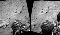
QUOTE (cswift @ Apr 16 2014, 10:48 AM)  ... I'd be interested to hear if others had more information or plausible ideas about this. That's a focus-stacked image, composed of portions of several images. The focus stacking algorithm probably didn't find a sharp version of the blurry region. The algorithm needs a subframe of some size to determine the best focus distance. The jump of the radial distance of the imaged rock within a small region, together with bright feature-rich foreground and dark feature-poor background, may have tricked the algorithm. The single images usually are only available as thumbnails, e.g. this and this image. Edit: This image combines the distance map (green channel) and the brightness of the original image (as red and blue channel) :
The small mismatch gets visible. (I don't think, that there is a way to fix this with a reasonable effort.) |
|
 |
 
|
|
|
Apr 16 2014, 08:10 PM
Post
#17
|
|
 Member Group: Members Posts: 809 Joined: 3-June 04 From: Brittany, France Member No.: 79 |
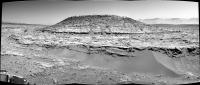
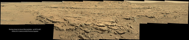
Panorama of Mount Remarkable and surroundings taken on sols 597 & 601 with MC34:
-------------------- |
|
|
|
|
Apr 16 2014, 08:47 PM
Post
#18
|
|
|
Member Group: Members Posts: 809 Joined: 3-June 04 From: Brittany, France Member No.: 79 |
-------------------- |
|
|
|
|
Apr 17 2014, 05:59 PM
Post
#19
|
|
|
Member Group: Members Posts: 809 Joined: 3-June 04 From: Brittany, France Member No.: 79 |
Mount Remarkable from the surface and from space!
 North is right on HiRISE picture. North is right on HiRISE picture.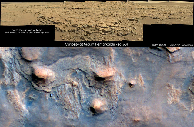
-------------------- |
|
|
|
|
Apr 17 2014, 09:08 PM
Post
#20
|
|
 Member Group: Members Posts: 334 Joined: 11-December 12 From: The home of Corby Crater (Corby-England) Member No.: 6783 |
Nice one Neo56,
The ultimate context camera! This really helps to visualise the rover position in my head, thanks. Why does the mound in the HiRISE image appear to be overhanging (dark shadows), yet appears to be a smoothish slope in the MC image, I know there are probably different lighting scenarios but .... Does the shape of the shadow reflect the profile of the mound? |
|
|
|
|
Apr 17 2014, 09:27 PM
Post
#21
|
|
|
Member Group: Members Posts: 334 Joined: 11-December 12 From: The home of Corby Crater (Corby-England) Member No.: 6783 |
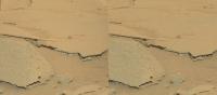
I was reading something today regarding fossilised raindrops and this part of a sol601 image seemed to fit the bill.
From what I read the theory seemed a bit 'iffy' (technical term!) What do the auspiscious members think? |
|
|
|
|
Apr 17 2014, 10:58 PM
Post
#22
|
|
|
Senior Member Group: Members Posts: 1043 Joined: 17-February 09 Member No.: 4605 |
I'm not sure that auspicious is the word you were looking for? Most probably gas escape as we have seen before but it would be helpful if you could identify the context image to confirm the scale.
|
|
|
|
|
Apr 17 2014, 11:08 PM
Post
#23
|
|||
|
Member Group: Members Posts: 866 Joined: 15-March 05 From: Santa Cruz, CA Member No.: 196 |
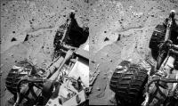
sol603 experimental crosseye (at left) using adjacent target as stand-in for the R image since the normal pair R image underexposure had to be contrast-matched (xeye at right). The swap-out on the left xeye below actually produced a better result imho.. but since this matches R to L as the panhead pivots L>R instead of L to R with static panhead, im not sure if the resultant interpupillary distance in this scenario is wider or tighter..
|
||
|
|
|
||
|
Apr 17 2014, 11:32 PM
Post
#24
|
|
|
Senior Member Group: Members Posts: 2346 Joined: 7-December 12 Member No.: 6780 |
QUOTE (algorithm @ Apr 17 2014, 10:27 PM) I was reading something today regarding fossilised raindrops and this part of a sol601 image seemed to fit the bill. ... Here are similar features visible. Since the features aren't exclusively parallel to the the suspected sedimentary layers, I'd think fossilized traces of raindrops are very unlikely. Interesting features, nevertheless! Edit: Panholes show some remote similarity. But the surface is probably too inclined for some of the features to allow them being panholes. Edit: Tafoni, and salt weathering can occur on inclined surfaces. That's one of the options I couldn't rule out easily. |
|
|
|
|
Apr 18 2014, 01:31 AM
Post
#25
|
|
|
Member Group: Members Posts: 866 Joined: 15-March 05 From: Santa Cruz, CA Member No.: 196 |
|
|
|
|
|
Apr 18 2014, 02:29 AM
Post
#26
|
|||
 Senior Member Group: Members Posts: 1465 Joined: 9-February 04 From: Columbus OH USA Member No.: 13 |
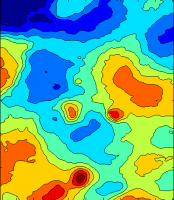
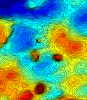
I was looking at the HiRISE DTM for the area & it looks like the peak of Mt. Remarkable is about 6 meters above the current rover position--is that right? Here's a map with 1m contours:
0.25m contours:
-------------------- |
||
|
|
|
||
|
Apr 18 2014, 02:43 AM
Post
#27
|
||
|
Solar System Cartographer Group: Members Posts: 10150 Joined: 5-April 05 From: Canada Member No.: 227 |
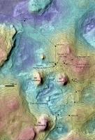
Wow, that's really nice - I just had to overlay it on my route map:
(and just in time! - jmknapp changed the map while I was busy overlaying it...) (oops - then he added it again - I can hardly keep up!) Phil -------------------- ... because the Solar System ain't gonna map itself.
Also to be found posting similar content on https://mastodon.social/@PhilStooke NOTE: everything created by me which I post on UMSF is considered to be in the public domain (NOT CC, public domain) |
|
|
|
|
|
|
Apr 18 2014, 08:46 AM
Post
#28
|
||
|
Senior Member Group: Members Posts: 2819 Joined: 22-April 05 From: Ridderkerk, Netherlands Member No.: 353 |
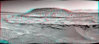
The Navcam NL B view on Sol 603.
Jan van Driel
|
|
|
|
|
|
|
Apr 18 2014, 09:12 AM
Post
#29
|
||
|
Senior Member Group: Members Posts: 2819 Joined: 22-April 05 From: Ridderkerk, Netherlands Member No.: 353 |
and the Stereo one from Sol 603.
Jan van Driel
|
|
|
|
|
|
|
Apr 18 2014, 10:03 AM
Post
#30
|
|
|
Senior Member Group: Members Posts: 1465 Joined: 9-February 04 From: Columbus OH USA Member No.: 13 |
QUOTE (Phil Stooke @ Apr 17 2014, 09:43 PM) (and just in time! - jmknapp changed the map while I was busy overlaying it...) (oops - then he added it again - I can hardly keep up!) Sorry--messing with the software & realized the contour spacing wasn't right at first. Nice overlay! -------------------- |
|
|
|
|

|
Lo-Fi Version | Time is now: 24th April 2024 - 12:42 PM |
|
RULES AND GUIDELINES Please read the Forum Rules and Guidelines before posting. IMAGE COPYRIGHT |
OPINIONS AND MODERATION Opinions expressed on UnmannedSpaceflight.com are those of the individual posters and do not necessarily reflect the opinions of UnmannedSpaceflight.com or The Planetary Society. The all-volunteer UnmannedSpaceflight.com moderation team is wholly independent of The Planetary Society. The Planetary Society has no influence over decisions made by the UnmannedSpaceflight.com moderators. |
SUPPORT THE FORUM Unmannedspaceflight.com is funded by the Planetary Society. Please consider supporting our work and many other projects by donating to the Society or becoming a member. |
|